Como WA 6152
10,192 addresses · 77 streets
Swan Electorate › South Perth LGA › Como · 5 km from Perth
📦 Thinking of moving here? Read the Como moving guide

Living Here
A riverside suburb just south of Perth's CBD, Como mixes established homes with apartments along the Swan. Households average 2.1 people and the median age is 38. Median household income is $1,780 a week, with rent around $350.
Como is a suburb of Western Australia, home to about 14,786 people, with a median age of 38. The typical household earns around $1,780 a week, with median rent near $350 a week. Most homes are townhouses. About 56% of households own their home and 41% rent. Most workers drive to work. Common community backgrounds include English, Australian, Irish. On the ABS socio-economic scale it sits in decile 10 of 10 nationally — a relatively advantaged area.
Over time — Census 2001 → 2021
Dashed line: district figures for the Como statistical area (SA2), the smallest area the ABS published before 2011. Solid line: Como itself.
Getting Around & Local Services
1 beach
3 physiotherapists
4 beauty salons
3 mechanics
1 electrician
Getting around. Train station: Canning Bridge, 1.4 km south-west · Metro station: Perth Underground, 5.2 km north · Railway halt: Canning Junction, 5.7 km south-east · Bus interchange: Curtin Central, 2.5 km east · Ferry wharf: Mends Street Jetty, 3.3 km north · Airport: Jandakot Airport, 10.6 km south.
Socio-economic Standing
Deciles from 1 (lowest) to 10 (highest), against all Australian suburbs. The overall figure weighs advantage and disadvantage together; economic resources counts income and housing, and education & jobs counts qualifications and occupation. They often differ. Source: ABS SEIFA 2021.
Tree cover
🌳 Tree canopy: 12% share of land under canopy · satellite map, 2020
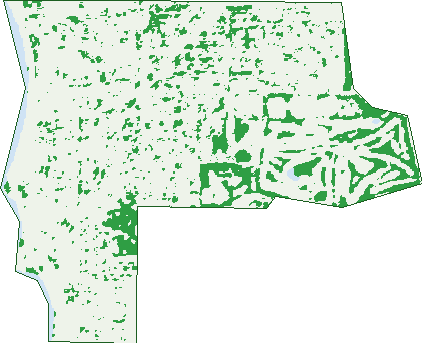
Green: 10 m cells where trees dominate, satellite 2021. Blue: water. The line is the suburb boundary.
| Canopy share, 1 m canopy height map, 2020 | 12.0% |
|---|---|
| Land with trees, 10 m satellite map, 2021 | 11.5% |
Demographics
Unemployment 4.6% · Labour-force participation 65.6%
Population by age in Como
| 0-4 | 716 |
|---|---|
| 5-14 | 1,221 |
| 15-19 | 643 |
| 20-24 | 1,229 |
| 25-34 | 2,757 |
| 35-44 | 2,117 |
| 45-54 | 1,549 |
| 55-64 | 1,519 |
| 65-74 | 1,513 |
| 75-84 | 901 |
| 85+ | 628 |
Dwelling types in Como
| House | 2,147 |
|---|---|
| Townhouse | 3,434 |
| Apartment | 948 |
| Other | 0 |
Households by weekly income in Como
| <$650 | 1,130 |
|---|---|
| $650-1,499 | 1,517 |
| $1,500-2,999 | 1,815 |
| $3,000+ | 1,652 |
Top ancestries in Como
| English | 5,311 |
|---|---|
| Australian | 4,178 |
| Other | 2,316 |
| Irish | 1,427 |
| Scottish | 1,414 |
| Chinese | 1,231 |
Housing tenure in Como
| Owned | 1,804 |
|---|---|
| Mortgage | 1,821 |
| Rented | 2,638 |
| Other | 224 |
Cars per household in Como
| 0 | 403 |
|---|---|
| 1 | 3,015 |
| 2 | 2,339 |
| 3 | 529 |
| 4+ | 185 |
Commute to work in Como
| Car | 4,992 |
|---|---|
| Train | 173 |
| Bus | 628 |
| Tram/ferry | 3 |
| Walked | 115 |
| Bicycle | 92 |
| Home | 716 |
Top countries of birth in Como
| England | 856 |
|---|---|
| Malaysia | 334 |
| India | 293 |
| China | 263 |
| New Zealand | 253 |
| South Africa | 248 |
Languages used at home in Como
| Mandarin | 490 |
|---|---|
| Cantonese | 190 |
| Italian | 159 |
| Indonesian | 150 |
| Persian | 145 |
| Spanish | 133 |
Birds & Wildlife Nearby
143,219 bird observations recorded near Como — most often seen:
- Willie Wagtail (7,011)
- Pacific Black Duck (6,665)
- Laughing Turtle-dove (6,611)
- Red Wattlebird (6,611)
- Rainbow Lorikeet (6,608)
- Australian Raven (6,321)
- Australian Magpie (5,734)
- South-western Australian Magpie (5,610)
- Australian White Ibis (5,158)
- Western Red Wattlebird (5,147)
- South-western Singing Honeyeater (5,027)
- Singing Honeyeater (4,891)
- Eastern Rainbow Lorikeet (4,879)
Show all 30 birds recorded near Como
- Little Pied Cormorant (4,794)
- Black Swan (4,722)
- Magpie-lark (4,702)
- Western Australian Raven (4,537)
- Little Black Cormorant (4,180)
- Silver Gull (4,135)
- Australasian Darter (4,096)
- Southern Willie Wagtail (3,989)
- Southern Magpie-lark (3,839)
- Eurasian Coot (3,737)
- Australian Wood Duck (3,633)
- Dusky Moorhen (3,594)
- Brown Honeyeater (3,529)
- Western Brown Honeyeater (3,428)
- Australian Pelican (3,408)
- Eastern Asian Spotted Dove (3,405)
- Twenty-eight Parrot (3,218)
Sightings reported by observers, not a survey, so the counts show what people record rather than what lives here. Source: Atlas of Living Australia.
Nearby Suburbs
The closest suburbs to Como:
- Manning (1.7 km)
- Karawara (2.1 km)
- South Perth (2.4 km)
- Kensington (2.5 km)
- Salter Point (2.6 km)
- Applecross (2.8 km)
- Waterford (3 km)
- Mount Pleasant (3.3 km)
Embed this suburb
Add this free Como stat card to your own site — just copy the code:
Preview:
Cite this page
Quoting these figures? Copy the credit line:
Keep an eye on Como
One email when this data meaningfully changes — new census figures, prices, rankings. No spam, unsubscribe anytime.
Streets
- Alston Avenue (147)
- Amery Street (57)
- Axford Street (233)
- Azalea Lane (1)
- Baldwin Street (114)
- Barker Avenue (71)
- Bessell Avenue (215)
- Bickley Crescent (2)
- Birdwood Avenue (157)
- Blamey Place (16)
- Bland Street (26)
- Brittain Street (75)
- Bruce Street (110)
- Cale Street (169)
- Canning Highway (529)
- Canning Parade (19)
- Cassey Street (12)
- Cloister Avenue (9)
- Clydesdale Street (253)
- Comer Street (375)
- Coode Street (256)
- Coolidge Street (67)
- Crawshaw Crescent (2)
- Daisy Lane (11)
- Dalmatia Place (5)
- Davilak Crescent (2)
- Davilak Street (26)
- Downey Drive (17)
- Edgecumbe Street (262)
- Ednah Street (130)
- Eleanor Street (35)
- Eric Street (233)
- Gardner Street (460)
- Gentilli Way (13)
- Gerald Street (49)
- Greenock Avenue (64)
- Hamlin Rise (8)
- Hazel Street (68)
- Henley Street (284)
- Hobbs Avenue (165)
- Hugh Court (9)
- Iris Lane (1)
- Jackson Road (34)
- Labouchere Road (481)
- Lawrence Street (45)
- Leonora Street (194)
- Ley Street (163)
- Lockhart Street (427)
- Manning Road (107)
- Mary Street (432)
- Max Forman Court (18)
- Mcdonald Street (198)
- Mcdougall Street (31)
- Mcnabb Loop (108)
- Melville Parade (325)
- Monash Avenue (188)
- Morrish Place (5)
- Morrison Street (76)
- Mount Henry Road (38)
- Murray Street (32)
- Park Street (249)
- Paterson Street (61)
- Philp Avenue (20)
- Poppy Lane (11)
- Preston Street (323)
- Robert Street (487)
- Ruth Street (27)
- Ryrie Avenue (209)
- Saunders Street (138)
- South Terrace (324)
- Stiles Court (7)
- Talbot Avenue (132)
- The Pines (6)
- Thelma Street (270)
- Throssell Street (12)
- Todd Avenue (213)
- Wooltana Street (44)