Clarkson WA 6030
7,015 addresses · 291 streets
Pearce Electorate › Wanneroo LGA › Clarkson · 32 km from Perth
📦 Thinking of moving here? Read the Clarkson moving guide

Living Here
Clarkson is a suburb of Western Australia, home to about 13,904 people, with a median age of 34. The typical household earns around $1,761 a week, with median rent near $350 a week. Most homes are houses. About 68% of households own their home and 31% rent. Most workers drive to work. Common community backgrounds include English, Australian, Irish. On the ABS socio-economic scale it sits in decile 4 of 10 nationally — a mid-range area.
Over time — Census 2001 → 2021
Dashed line: district figures for the Clarkson statistical area (SA2), the smallest area the ABS published before 2011. Solid line: Clarkson itself.
Getting Around & Local Services
4 supermarkets
1 beach
1 Catholic church
1 medical clinic
2 dentists
1 optometrist
1 hospital
3 childcare & kindergartens
1 library
1 post office
10 service stations
3 gyms & sports centres
1 hardware store
2 hairdressers
2 beauty salons
1 electrician
1 plumber
2 places to stay
Getting around. Train station: Clarkson, 1.2 km east · Airport: Perth Airport, 36.3 km south-east.
Socio-economic Standing
Deciles from 1 (lowest) to 10 (highest), against all Australian suburbs. The overall figure weighs advantage and disadvantage together; economic resources counts income and housing, and education & jobs counts qualifications and occupation. They often differ. Source: ABS SEIFA 2021.
Tree cover
🌳 Tree canopy: 6.8% share of land under canopy · satellite map, 2020
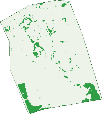
Green: 10 m cells where trees dominate, satellite 2021. Blue: water. The line is the suburb boundary.
| Canopy share, 1 m canopy height map, 2020 | 6.8% |
|---|---|
| Land with trees, 10 m satellite map, 2021 | 6.8% |
Demographics
Unemployment 6.5% · Labour-force participation 69.9%
Population by age in Clarkson
| 0-4 | 1,068 |
|---|---|
| 5-14 | 1,913 |
| 15-19 | 795 |
| 20-24 | 974 |
| 25-34 | 2,462 |
| 35-44 | 2,172 |
| 45-54 | 1,774 |
| 55-64 | 1,468 |
| 65-74 | 841 |
| 75-84 | 360 |
| 85+ | 71 |
Dwelling types in Clarkson
| House | 4,500 |
|---|---|
| Townhouse | 494 |
| Apartment | 44 |
| Other | 0 |
Households by weekly income in Clarkson
| <$650 | 608 |
|---|---|
| $650-1,499 | 1,299 |
| $1,500-2,999 | 1,788 |
| $3,000+ | 873 |
Top ancestries in Clarkson
| English | 5,539 |
|---|---|
| Australian | 3,576 |
| Other | 2,257 |
| Irish | 1,279 |
| Scottish | 1,279 |
| Ancestry NS | 823 |
Housing tenure in Clarkson
| Owned | 789 |
|---|---|
| Mortgage | 2,608 |
| Rented | 1,542 |
| Other | 42 |
Cars per household in Clarkson
| 0 | 208 |
|---|---|
| 1 | 1,898 |
| 2 | 2,025 |
| 3 | 625 |
| 4+ | 230 |
Commute to work in Clarkson
| Car | 4,658 |
|---|---|
| Train | 381 |
| Bus | 81 |
| Tram/ferry | 0 |
| Walked | 67 |
| Bicycle | 15 |
| Home | 430 |
Top countries of birth in Clarkson
| England | 1,660 |
|---|---|
| New Zealand | 598 |
| South Africa | 507 |
| India | 272 |
| Scotland | 264 |
| Philippines | 257 |
Languages used at home in Clarkson
| Afrikaans | 222 |
|---|---|
| Punjabi | 195 |
| Mandarin | 181 |
| Tagalog | 116 |
| Arabic | 115 |
| Filipino | 108 |
Birds & Wildlife Nearby
18,334 bird observations recorded near Clarkson — most often seen:
- Western Australian Raven (1,566)
- Laughing Turtle-dove (1,528)
- South-western New Holland Honeyeater (1,462)
- Western Red Wattlebird (1,400)
- Southern Willie Wagtail (1,341)
- South-western Singing Honeyeater (1,319)
- Eastern Rainbow Lorikeet (901)
- Western Galah (802)
- Northern Little Corella (780)
- Western Welcome Swallow (759)
- Western Silvereye (673)
- Eastern Asian Spotted Dove (540)
- Western Brown Honeyeater (506)
Show all 30 birds recorded near Clarkson
- Southern Magpie-lark (449)
- Rock Dove (375)
- Australian Raven (354)
- Western White-cheeked Honeyeater (344)
- Willie Wagtail (336)
- Mainland Black-faced Cuckoo-shrike (306)
- Singing Honeyeater (306)
- Silver Gull (264)
- South-western Australian Magpie (262)
- Twenty-eight Parrot (246)
- Galah (244)
- Red Wattlebird (227)
- White-cheeked Honeyeater (224)
- Welcome Swallow (217)
- Rainbow Lorikeet (208)
- Silvereye (202)
- Australian Magpie (193)
Sightings reported by observers, not a survey, so the counts show what people record rather than what lives here. Source: Atlas of Living Australia.
Nearby Suburbs
The closest suburbs to Clarkson:
- Mindarie (1.7 km)
- Tamala Park (2 km)
- Merriwa (2.8 km)
- Ridgewood (2.9 km)
- Kinross (3.6 km)
- Quinns Rocks (3.7 km)
- Burns Beach (4.2 km)
- Neerabup (5 km)
Embed this suburb
Add this free Clarkson stat card to your own site — just copy the code:
Preview:
Cite this page
Quoting these figures? Copy the credit line:
Keep an eye on Clarkson
One email when this data meaningfully changes — new census figures, prices, rankings. No spam, unsubscribe anytime.
Streets
- Abercrombie Street (29)
- Aerial Way (28)
- Ainsbury Parade (47)
- Airlie Chase (19)
- Aldersea Circle (100)
- Aldridge Rise (14)
- Amazon Lane (1)
- Ambesia Road (11)
- Antares Street (55)
- Arvada Street (53)
- Aslings Court (10)
- Astor Link (1)
- Attwood Place (38)
- Auburn Street (18)
- Aviator Boulevard (114)
- Badcoe Alley (19)
- Bago Way (8)
- Balin Lane (5)
- Banfield Grove (26)
- Bateson Heights (44)
- Beachport Retreat (31)
- Beachtown Vista (16)
- Beilken Way (7)
- Belford Way (7)
- Belleville Gardens (36)
- Biamanga Loop (36)
- Bindarri Road (6)
- Bliss Way (16)
- Bolitho Way (20)
- Bondi Link (5)
- Boranup Avenue (79)
- Border Way (9)
- Bouvard Walk (24)
- Bulburin Street (41)
- Burnett Drive (54)
- Burra Court (10)
- Cactus Link (13)
- Caldwell Turn (30)
- Caloundra Road (65)
- Cansos Street (29)
- Capitol Turn (44)
- Carberry Square (41)
- Caribbean Circuit (10)
- Cassano Boulevard (8)
- Celebration Boulevard (145)
- Chattanooga Vista (62)
- Cheney Vale (11)
- Cherokee Green (46)
- Chesterton Street (6)
- Cleland Close (10)
- Coaldale Link (20)
- Cocoparra Loop (15)
- Cody Way (4)
- Commodore Avenue (55)
- Conimbla Road (14)
- Connolly Drive (6)
- Connors Retreat (22)
- Cordova Turn (10)
- Cronulla Road (4)
- Crouch Vista (6)
- Cylinders Loop (17)
- Danaher Mews (30)
- Dandenong Parade (30)
- Debelle Way (21)
- Dekalb Link (9)
- Delany Mews (15)
- Dewar Mews (44)
- Downes Lane (6)
- Drimmie Road (21)
- Dulles Way (19)
- Durrington Glade (35)
- Durs Place (3)
- Ebb Way (4)
- Edenbrooke Terrace (19)
- Elkington Mews (29)
- Elmhurst Drive (36)
- Elsbury Approach (58)
- Else Way (2)
- Elvina Rise (5)
- Ely Place (15)
- Emerson Turn (24)
- Eveleigh Boulevard (17)
- Everingham Street (42)
- Expedition Drive (12)
- Farren Heights (10)
- Felix Lane (7)
- Fleming Parkway (19)
- Fordham Avenue (15)
- Fortis Road (17)
- Frawley Ramble (25)
- Gaffney Ridge (18)
- Galvin Heights (15)
- Garrett Way (9)
- Garrigan Place (24)
- Gaudi Way (52)
- Glennon View (12)
- Grampians Drive (45)
- Grandoak Drive (45)
- Gunnamatta Loop (24)
- Hacienda Drive (31)
- Hannaford Avenue (39)
- Harmony Avenue (27)
- Haskell Gardens (33)
- Haymount Way (7)
- Hemmings Close (13)
- Henson Way (12)
- Heppell Gardens (19)
- Hester Avenue (3)
- Hidden Valley Retreat (29)
- Hilliger Way (23)
- Hollywood Heights (15)
- Holwell Gardens (28)
- Homestead Drive (39)
- Homevale Way (15)
- Hopman Rise (13)
- Hubble Parkway (8)
- Hurst Trail (28)
- Hyland Crescent (43)
- Injidup Loop (38)
- Jamaica Lane (19)
- Jervis Close (4)
- Kaburua Road (30)
- Kalbarri Road (12)
- Karijini Loop (25)
- Kawana Place (8)
- Keady Rise (33)
- Kempton Grove (25)
- Kendari Road (14)
- Key Largo Drive (55)
- Kidston Court (5)
- Kirra Lane (6)
- Kitson Turn (17)
- Koenig Way (19)
- Kuranda Road (19)
- Kyara Court (16)
- La Mirada Avenue (28)
- La Paz Link (6)
- Labuan Way (28)
- Laddon Road (6)
- Ladera Drive (30)
- Lakewood Terrace (26)
- Landa Court (6)
- Lantern Way (29)
- Larsson Walk (22)
- Las Ramblas Circle (14)
- Lawrie Court (11)
- Lenswood Retreat (18)
- Liberty Drive (151)
- Lilydale Court (6)
- Linlee Lane (6)
- Lithgow Drive (57)
- Littabella Road (14)
- Loftia View (28)
- Lomita Link (31)
- Longleaf Drive (16)
- Lorimer Street (12)
- Lower Keys Drive (31)
- Macdonnell Avenue (29)
- Magenta Rise (16)
- Makassar Way (65)
- Malone Mews (22)
- Manila Road (13)
- Mapleton Avenue (27)
- Marino Road (11)
- Marmion Avenue (20)
- Maroochydore Way (15)
- Maroubra Way (12)
- Mcallister Boulevard (46)
- Mcpherson Avenue (23)
- Meech Way (5)
- Meere Lane (7)
- Melbourne Loop (48)
- Metro Boulevard (22)
- Miami Lane (3)
- Morton Grove (12)
- Mowbray Square (66)
- Musa Way (6)
- Myall Fairway (17)
- Nalder Way (11)
- Neerabup Road (20)
- Newlin Mews (15)
- Nilsen Ridge (11)
- Ningaloo Bend (28)
- Nomad Drive (31)
- Northcliffe Avenue (13)
- Oakpark Green (38)
- Observatory Drive (50)
- Ocean Keys Boulevard (369)
- Orange Grove Boulevard (14)
- Orchid Court (16)
- Orenco Bend (60)
- Ormiston Gardens (23)
- Oxley Court (4)
- Palladio Pass (12)
- Pare Lane (8)
- Pavonia Link (41)
- Pebbly Way (8)
- Pengilly Way (16)
- Penola Court (9)
- Pensacola Terrace (45)
- Perkins Drive (32)
- Perrin Crest (13)
- Petersen Close (14)
- Petre Grove (17)
- Pike Lane (2)
- Pirianda Close (19)
- Pitchford Glade (47)
- Polglase Fairway (38)
- Pollock Way (35)
- Pomelaa Way (50)
- Pomona Way (4)
- Porongurup Drive (43)
- Pratt Lane (12)
- Preserve Link (10)
- Pridmore Glen (46)
- Prior Pass (6)
- Rathmines Street (40)
- Redbank Rise (30)
- Redfern Bend (17)
- Renshaw Boulevard (58)
- Ridglea Link (17)
- Rigel Way (2)
- Riverlinks Drive (25)
- Rooke Way (6)
- Rooney Street (26)
- Rossiters Cove (8)
- Roulettes Parade (47)
- Rudall Court (19)
- Salamanca Turn (41)
- Salishan Street (29)
- San Remo Bend (9)
- Sandow Green (25)
- Santa Clara Crescent (27)
- Sarasota Pass (20)
- Seabrook Grove (24)
- Seeadler Street (19)
- Serpentine Gardens (35)
- Shinners Green (22)
- Silveroaks Way (4)
- Sloman Lane (5)
- Somerly Drive (41)
- Sprigg Pass (5)
- Springthorpe Terrace (27)
- St Kilda Turn (16)
- Stain Way (3)
- Stanmore Place (12)
- Steen Court (10)
- Stokes Retreat (16)
- Sykes Cove (8)
- Tamarama Crescent (18)
- Tambelyn Street (11)
- Tamborine Road (27)
- Tarlo Grange (1)
- Tarong Way (16)
- Tarra Close (12)
- Tathra Way (10)
- Tebb Mews (11)
- The Straits (23)
- Throssell Place (16)
- Tindal Way (5)
- Tobin Hill (8)
- Tomas View (10)
- Trask Dale (8)
- Trephina Mews (32)
- Trinity Way (12)
- Tufnell Lane (4)
- Tupelo Fairway (18)
- Turon Way (4)
- Tuxedo Link (19)
- Utica Terrace (8)
- Verrado Way (9)
- Vetter Road (35)
- Vickery Loop (21)
- Victorsen Parade (21)
- Wales Court (18)
- Wallis Avenue (7)
- Walpole Place (14)
- Walyunga Boulevard (76)
- Warby Lane (3)
- Waring Green (55)
- Waters Street (9)
- Webster Brace (5)
- Werri Place (5)
- Wheeler Link (5)
- Whiston Crescent (37)
- Willoughby Retreat (51)
- Winmore Way (3)
- Woodmont Way (7)
- Worth Street (8)
- Wowomi Street (15)
- Yaroomba Place (21)