Broome WA 6725
3,754 addresses · 79 streets
Durack Electorate › Broome LGA › Broome · 1682 km from Perth
📦 Thinking of moving here? Read the Broome moving guide

Living Here
Broome is a suburb of Western Australia, home to about 3,797 people, with a median age of 36. The typical household earns around $1,802 a week, with median rent near $300 a week. Most homes are houses. About 39% of households own their home and 59% rent. Most workers drive to work. Common community backgrounds include Aboriginal, English, Australian. On the ABS socio-economic scale it sits in decile 3 of 10 nationally — a more disadvantaged area.
Over time — Census 2001 → 2021
Dashed line: district figures for the Broome statistical area (SA2), the smallest area the ABS published before 2011. Solid line: Broome itself.
Getting Around & Local Services
4 supermarkets
2 parks
2 beaches
1 pharmacy
1 medical clinic
2 dentists
1 hospital
1 childcare centre
1 library
1 post office
4 service stations
4 gyms & sports centres
1 golf club
2 hardware stores
3 hairdressers
1 mechanic
Getting around. Airport: Broome International Airport, 1.5 km north.
Socio-economic Standing
Deciles from 1 (lowest) to 10 (highest), against all Australian suburbs. The overall figure weighs advantage and disadvantage together; economic resources counts income and housing, and education & jobs counts qualifications and occupation. They often differ. Source: ABS SEIFA 2021.
Tree cover
🌳 Tree canopy: 20.3% share of land under canopy · satellite map, 2020
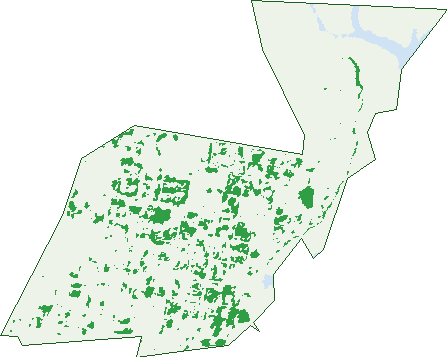
Green: 10 m cells where trees dominate, satellite 2021. Blue: water. The line is the suburb boundary.
| Canopy share, 1 m canopy height map, 2020 | 20.3% |
|---|---|
| Land with trees, 10 m satellite map, 2021 | 8.4% |
Demographics
Unemployment 6.6% · Labour-force participation 57.3%
Population by age in Broome
| 0-4 | 211 |
|---|---|
| 5-14 | 534 |
| 15-19 | 237 |
| 20-24 | 208 |
| 25-34 | 638 |
| 35-44 | 555 |
| 45-54 | 554 |
| 55-64 | 472 |
| 65-74 | 260 |
| 75-84 | 90 |
| 85+ | 30 |
Dwelling types in Broome
| House | 769 |
|---|---|
| Townhouse | 270 |
| Apartment | 60 |
| Other | 45 |
Households by weekly income in Broome
| <$650 | 191 |
|---|---|
| $650-1,499 | 229 |
| $1,500-2,999 | 339 |
| $3,000+ | 224 |
Top ancestries in Broome
| Aboriginal | 1,089 |
|---|---|
| English | 928 |
| Australian | 893 |
| Ancestry NS | 669 |
| Other | 394 |
| Irish | 269 |
Housing tenure in Broome
| Owned | 168 |
|---|---|
| Mortgage | 265 |
| Rented | 656 |
| Other | 19 |
Cars per household in Broome
| 0 | 167 |
|---|---|
| 1 | 392 |
| 2 | 332 |
| 3 | 132 |
| 4+ | 83 |
Commute to work in Broome
| Car | 1,036 |
|---|---|
| Train | 5 |
| Bus | 22 |
| Tram/ferry | 0 |
| Walked | 155 |
| Bicycle | 88 |
| Home | 84 |
Top countries of birth in Broome
| England | 76 |
|---|---|
| Philippines | 69 |
| New Zealand | 62 |
| South Africa | 28 |
| China | 26 |
| India | 25 |
Languages used at home in Broome
| Australian Indigenous | 114 |
|---|---|
| Spanish | 45 |
| Filipino | 33 |
| Thai | 29 |
| Mandarin | 28 |
| Tagalog | 24 |
Birds & Wildlife Nearby
87,906 bird observations recorded near Broome — most often seen:
- Black Kite (5,225)
- Australian White Ibis (4,822)
- Silver Gull (4,753)
- Masked Lapwing (4,395)
- Little Friarbird (4,251)
- Torresian Crow (3,765)
- Magpie-lark (3,684)
- Straw-necked Ibis (3,431)
- Red-collared Lorikeet (3,262)
- Australian Pelican (3,192)
- Plumed Whistling-duck (3,064)
- Singing Honeyeater (3,043)
- Rainbow Bee-eater (2,949)
Show all 30 birds recorded near Broome
- Whistling Kite (2,835)
- Peaceful Dove (2,617)
- Whiskered Tern (2,578)
- Pacific Black Duck (2,476)
- Pied Butcherbird (2,426)
- Brown Honeyeater (2,389)
- Royal Spoonbill (2,240)
- Black-faced Cuckoo-shrike (2,199)
- Great Bowerbird (2,183)
- Crested Pigeon (2,180)
- Bar-shouldered Dove (2,117)
- Eurasian Coot (2,092)
- Grey Teal (2,031)
- Red-winged Parrot (1,978)
- Little Corella (1,921)
- Hardhead (1,914)
- Australasian Grebe (1,894)
Sightings reported by observers, not a survey, so the counts show what people record rather than what lives here. Source: Atlas of Living Australia.
Nearby Suburbs
The closest suburbs to Broome:
Embed this suburb
Add this free Broome stat card to your own site — just copy the code:
Preview:
Cite this page
Quoting these figures? Copy the credit line:
Keep an eye on Broome
One email when this data meaningfully changes — new census figures, prices, rankings. No spam, unsubscribe anytime.
Streets
- Anne Street (181)
- Bardwell Street (13)
- Barker Street (47)
- Blackman Street (71)
- Blick Drive (14)
- Boab Court (33)
- Bray Place (6)
- Broome Road (9)
- Carmody Court (17)
- Carnarvon Street (107)
- Chapple Street (20)
- Clementson Street (55)
- Coverley Corner (9)
- Cox Place (20)
- D'antoine Street (18)
- Dampier Terrace (81)
- Demco Drive (77)
- Dickson Drive (9)
- Dora Street (177)
- Durack Crescent (71)
- Ellies Court (37)
- Farrell Street (28)
- Forrest Street (212)
- Frederick Street (71)
- Frewer Avenue (27)
- Gray Street (4)
- Gregory Street (18)
- Guy Street (212)
- Haas Street (20)
- Hamersley Street (105)
- Haynes Street (23)
- Herbert Street (169)
- Hopton Street (65)
- Hunter Street (62)
- Jones Place (2)
- Kennedy Court (8)
- Kerr Street (26)
- Leichhardt Place (19)
- Livingstone Street (16)
- Louis Street (57)
- Lucas Street (20)
- Lullfitz Drive (2)
- Male Court (15)
- Martin Court (18)
- Mary Street (28)
- Matsumoto Street (1)
- Miller Way (48)
- Milner Street (48)
- Mirda Road (2)
- Mostyn Place (18)
- Napier Terrace (31)
- Norman Street (12)
- Ord Way (33)
- Orr Street (45)
- Owens Street (11)
- Paddy Court (24)
- Pelcan Gardens (15)
- Pembroke Road (75)
- Piggott Way (51)
- Placanica Place (25)
- Port Drive (30)
- Pryor Drive (27)
- Puertollano Place (28)
- Raible Road (30)
- Rivergum Avenue (18)
- Robert Street (46)
- Robinson Street (298)
- Saville Street (118)
- Scott Street (4)
- Short Street (48)
- Stewart Street (40)
- Stracke Cove (21)
- Streeter Avenue (35)
- Talboys Place (14)
- Tang Street (35)
- Tolentino Street (10)
- Walcott Street (127)
- Weld Street (62)
- Wing Place (25)