Bridgetown WA 6255
2,607 addresses · 163 streets
O'Connor Electorate › Bridgetown-Greenbushes LGA › Bridgetown · 224 km from Perth
📦 Thinking of moving here? Read the Bridgetown moving guide

Living Here
Bridgetown is a suburb of Western Australia, home to about 3,168 people, with a median age of 52. The typical household earns around $1,082 a week, with median rent near $300 a week. Most homes are houses. About 78% of households own their home and 19% rent. Most workers drive to work. Common community backgrounds include English, Australian, Scottish. On the ABS socio-economic scale it sits in decile 4 of 10 nationally — a mid-range area.
Over time — Census 2001 → 2021
Dashed line: district figures for the Bridgetown - Boyup Brook statistical area (SA2), the smallest area the ABS published before 2011. Solid line: Bridgetown itself.
Getting Around & Local Services
3 supermarkets
1 park
1 medical clinic
1 hospital
1 library
1 post office
2 service stations
2 gyms & sports centres
1 bakery
2 butchers
2 hardware stores
1 beauty salon
3 mechanics
1 plumber
1 carpenter
Getting around. Airport: Manjimup Airport, 34 km south.
Socio-economic Standing
Deciles from 1 (lowest) to 10 (highest), against all Australian suburbs. The overall figure weighs advantage and disadvantage together; economic resources counts income and housing, and education & jobs counts qualifications and occupation. They often differ. Source: ABS SEIFA 2021.
Tree cover
🌳 Tree canopy: 33.1% share of land under canopy · satellite map, 2020
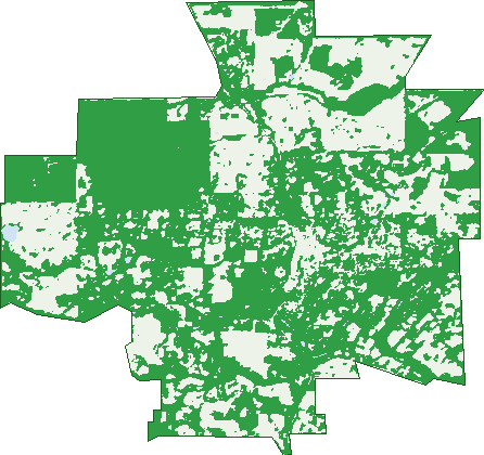
Green: 10 m cells where trees dominate, satellite 2021. Blue: water. The line is the suburb boundary.
| Canopy share, 1 m canopy height map, 2020 | 33.1% |
|---|---|
| Land with trees, 10 m satellite map, 2021 | 62.4% |
Demographics
Unemployment 4.4% · Labour-force participation 50.5%
Population by age in Bridgetown
| 0-4 | 139 |
|---|---|
| 5-14 | 356 |
| 15-19 | 160 |
| 20-24 | 99 |
| 25-34 | 233 |
| 35-44 | 296 |
| 45-54 | 428 |
| 55-64 | 507 |
| 65-74 | 607 |
| 75-84 | 276 |
| 85+ | 76 |
Dwelling types in Bridgetown
| House | 1,194 |
|---|---|
| Townhouse | 56 |
| Apartment | 7 |
| Other | 10 |
Households by weekly income in Bridgetown
| <$650 | 304 |
|---|---|
| $650-1,499 | 405 |
| $1,500-2,999 | 287 |
| $3,000+ | 139 |
Top ancestries in Bridgetown
| English | 1,679 |
|---|---|
| Australian | 1,138 |
| Scottish | 376 |
| Irish | 368 |
| Ancestry NS | 221 |
| Other | 141 |
Housing tenure in Bridgetown
| Owned | 541 |
|---|---|
| Mortgage | 440 |
| Rented | 237 |
| Other | 42 |
Cars per household in Bridgetown
| 0 | 41 |
|---|---|
| 1 | 456 |
| 2 | 481 |
| 3 | 175 |
| 4+ | 100 |
Commute to work in Bridgetown
| Car | 869 |
|---|---|
| Train | 0 |
| Bus | 14 |
| Tram/ferry | 0 |
| Walked | 53 |
| Bicycle | 0 |
| Home | 110 |
Top countries of birth in Bridgetown
| England | 373 |
|---|---|
| New Zealand | 92 |
| Scotland | 28 |
| South Africa | 21 |
| Germany | 19 |
| Netherlands | 18 |
Languages used at home in Bridgetown
| German | 21 |
|---|---|
| Tagalog | 13 |
| Thai | 8 |
| Vietnamese | 8 |
| Japanese | 7 |
| French | 6 |
Birds & Wildlife Nearby
7,991 bird observations recorded near Bridgetown — most often seen:
- New Holland Honeyeater (593)
- Australian Ringneck (497)
- Common Bronzewing (443)
- Silvereye (370)
- Red-capped Parrot (344)
- Willie Wagtail (332)
- Splendid Fairy-wren (320)
- Red Wattlebird (319)
- Western Rosella (313)
- Gilbert's Honeyeater (293)
- Yellow-rumped Thornbill (279)
- Australian Magpie (277)
- Tree Martin (272)
Show all 30 birds recorded near Bridgetown
- Elegant Parrot (269)
- Pacific Black Duck (261)
- Magpie-lark (245)
- Australian Raven (236)
- South-western Australian Magpie (233)
- Australian Wood Duck (232)
- Brown Honeyeater (213)
- Eurasian Coot (194)
- Galah (186)
- Red-eared Firetail (182)
- Twenty-eight Parrot (182)
- Grey Fantail (173)
- Red-tailed Black Cockatoo (153)
- Welcome Swallow (153)
- Rufous Whistler (148)
- South-western Scarlet Robin (140)
- Scarlet Robin (139)
Sightings reported by observers, not a survey, so the counts show what people record rather than what lives here. Source: Atlas of Living Australia.
Nearby Suburbs
The closest suburbs to Bridgetown:
- Kangaroo Gully (4.4 km)
- Hester Brook (4.7 km)
- Glenlynn (5.2 km)
- Hester (6.1 km)
- Wandillup (8.6 km)
- Maranup (9.4 km)
- Sunnyside (11.9 km)
- Catterick (12.2 km)
Embed this suburb
Add this free Bridgetown stat card to your own site — just copy the code:
Preview:
Cite this page
Quoting these figures? Copy the credit line:
Keep an eye on Bridgetown
One email when this data meaningfully changes — new census figures, prices, rankings. No spam, unsubscribe anytime.
Streets
- Abbotts Street (2)
- Aberdeen Avenue (30)
- Adams Road (3)
- Allnutt Street (63)
- Apex Grove (15)
- Archer Street (1)
- Argyll Avenue (13)
- Arkle Road (4)
- Austin Dale (2)
- Bain View (2)
- Balmoral Drive (54)
- Barlee Street (42)
- Bartlett Place (2)
- Bevan Street (2)
- Blechynden Street (75)
- Bovell Street (8)
- Brand Street (18)
- Bridgetown-boyup Brook Road (7)
- Brockman Highway (6)
- Brockman Street (17)
- Bunbury Street (12)
- Bussell Street (4)
- Campbell Street (31)
- Carey Street (21)
- Carnegie Close (13)
- Charolais Close (9)
- Chevis Court (14)
- Civic Lane (3)
- Condil Place (1)
- Coronation Street (26)
- Corriedale Court (5)
- Corymbia Close (1)
- Coverley Road (7)
- Crawford Street (2)
- Cullen Street (3)
- Cutmore Crescent (15)
- Dairy Lane (1)
- Davies Street (12)
- Dean Street (31)
- Devon Place (9)
- Dexter Rise (10)
- Dickenson Street (1)
- Doust Street (13)
- Dreyfus Street (25)
- Dusting Drive (2)
- East Blackwood Terrace (10)
- Eastcott Avenue (3)
- Ecclesiastic Close (15)
- Edward Road (6)
- Eedle Terrace (32)
- Emerson Avenue (9)
- Ethel Street (14)
- Everingham Road (6)
- Ewing Place (11)
- Farmers Lane (1)
- Farrell Street (9)
- Flintoff Road (7)
- Ford Road (11)
- Forrest Street (71)
- Galloway Drive (24)
- Geegelup View (8)
- George Street (8)
- Giblett Road (17)
- Gifford Road (59)
- Gleneagles Drive (49)
- Greys Hill Road (13)
- Greystones Road (2)
- Hackett Street (21)
- Haig Street (5)
- Hampton Street (164)
- Hassell Street (7)
- Henry Street (20)
- Hereford Heights (4)
- Hester Road (5)
- Hester Street (24)
- Highland Avenue (11)
- Hillcrest Rise (6)
- Hornby Street (1)
- Hovea Close (4)
- Huggett Place (4)
- Hughes Place (4)
- Inglis Street (5)
- Karrak Rise (2)
- Kincaid Close (18)
- Kularda Place (3)
- Lakeview Crescent (32)
- Lansdowne View (13)
- Lavender Lane (1)
- Laverty Street (5)
- Layman Street (7)
- Lefroy Road (8)
- Les Woodhead Avenue (4)
- Limousin View (6)
- Lockley Avenue (9)
- Loftie Street (16)
- Lorikeet Ridge (16)
- Manor Ridge (31)
- Maslin Street (20)
- Mattamattup Street (23)
- May Street (3)
- Mcalinden Street (16)
- Mclarty Street (11)
- Mirimiri Street (14)
- Molyneux Way (8)
- Moore Place (7)
- Moriarty Street (2)
- Mottram Street (6)
- Moulton Street (5)
- Mount Street (4)
- Murray Grey Court (10)
- Nelson Street (73)
- Orchard Close (9)
- Padbury Road (49)
- Palmers Road (12)
- Park Avenue (6)
- Peninsula Road (41)
- Phillips Street (25)
- Pioneer Street (3)
- Polly Dakin Drive (2)
- Possum Close (2)
- Pratt Road (4)
- Railway Terrace (15)
- Reverends Ramble (13)
- River Road (24)
- Riverview Close (16)
- Roe Street (76)
- Rose Street (30)
- Rosella Rise (11)
- Rowan Close (9)
- Rowley Street (14)
- Scott Street (26)
- Scriven Road (5)
- Shephard Street (11)
- Simmental Way (9)
- Sittella Lane (2)
- Skye Lane (18)
- Smith Street (8)
- Somme Street (23)
- Son Place (2)
- South Western Highway (32)
- Spencer Street (66)
- Steere Street (92)
- Stephens Street (12)
- Stewart Street (6)
- Stirling Street (10)
- Stonehaven Grove (5)
- Sunridge Drive (51)
- Sutton Close (3)
- Taylors Road (2)
- Thompson Street (18)
- Toyer Street (11)
- Turner Road (56)
- Tweed Road (20)
- Vialls Grove (2)
- Walter Road (21)
- Walter Street (3)
- West Blackwood Terrace (13)
- Wheatley Street (7)
- Whittells Road (12)
- Wilkins Road (8)
- Williams Street (3)
- Willmott Road (1)
- Woodlands View (8)