Bennett Springs WA 6063
2,535 addresses · 113 streets
Hasluck Electorate › Swan LGA › Bennett Springs · 13 km from Perth
📦 Thinking of moving here? Read the Bennett Springs moving guide

Living Here
Bennett Springs is a suburb of Western Australia, home to about 5,929 people, with a median age of 32. The typical household earns around $2,077 a week, with median rent near $418 a week. Most homes are houses. About 83% of households own their home and 16% rent. Most workers drive to work. Common community backgrounds include Australian, English, Indian. On the ABS socio-economic scale it sits in decile 5 of 10 nationally — a mid-range area.
Over time — Census 2001 → 2021
Dashed line: district figures for the Beechboro statistical area (SA2), the smallest area the ABS published before 2011. Solid line: Bennett Springs itself.
Getting Around & Local Services
3 cafés & restaurants
6 supermarkets
3 doctors & medical clinics
2 dentists
1 optometrist
1 vet
2 childcare & kindergartens
5 gyms & sports centres
2 playgrounds
2 hairdressers
1 beauty salon
1 mechanic
2 electricians
Getting around. Train station: Ballajura, 2.2 km north-west · Tram stop: Mussel Pool, 1.5 km north · Bus interchange: Galleria Bus Station, 6.1 km south-west · Ferry wharf: Mandoon Jetty, 5.1 km east · Airport: Perth Airport, 9.7 km south.
Socio-economic Standing
Deciles from 1 (lowest) to 10 (highest), against all Australian suburbs. The overall figure weighs advantage and disadvantage together; economic resources counts income and housing, and education & jobs counts qualifications and occupation. They often differ. Source: ABS SEIFA 2021.
Tree cover
🌳 Tree canopy: 6.7% share of land under canopy · satellite map, 2020
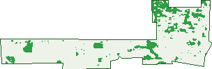
Green: 10 m cells where trees dominate, satellite 2021. Blue: water. The line is the suburb boundary.
| Canopy share, 1 m canopy height map, 2020 | 6.7% |
|---|---|
| Land with trees, 10 m satellite map, 2021 | 15.5% |
Demographics
Unemployment 5.7% · Labour-force participation 69.8%
Population by age in Bennett Springs
| 0-4 | 423 |
|---|---|
| 5-14 | 1,004 |
| 15-19 | 475 |
| 20-24 | 421 |
| 25-34 | 870 |
| 35-44 | 978 |
| 45-54 | 779 |
| 55-64 | 576 |
| 65-74 | 282 |
| 75-84 | 105 |
| 85+ | 20 |
Dwelling types in Bennett Springs
| House | 1,651 |
|---|---|
| Townhouse | 25 |
| Apartment | 30 |
| Other | 0 |
Households by weekly income in Bennett Springs
| <$650 | 117 |
|---|---|
| $650-1,499 | 395 |
| $1,500-2,999 | 634 |
| $3,000+ | 379 |
Top ancestries in Bennett Springs
| Other | 2,042 |
|---|---|
| Australian | 1,153 |
| English | 1,106 |
| Indian | 606 |
| Vietnamese | 433 |
| Ancestry NS | 302 |
Housing tenure in Bennett Springs
| Owned | 313 |
|---|---|
| Mortgage | 1,089 |
| Rented | 270 |
| Other | 9 |
Cars per household in Bennett Springs
| 0 | 34 |
|---|---|
| 1 | 352 |
| 2 | 736 |
| 3 | 338 |
| 4+ | 222 |
Commute to work in Bennett Springs
| Car | 2,267 |
|---|---|
| Train | 35 |
| Bus | 53 |
| Tram/ferry | 0 |
| Walked | 23 |
| Bicycle | 4 |
| Home | 147 |
Top countries of birth in Bennett Springs
| India | 455 |
|---|---|
| Vietnam | 325 |
| Afghanistan | 198 |
| New Zealand | 156 |
| Myanmar | 154 |
| England | 142 |
Languages used at home in Bennett Springs
| Vietnamese | 480 |
|---|---|
| Arabic | 333 |
| Gujarati | 228 |
| Punjabi | 138 |
| Persian | 94 |
| Tagalog | 83 |
Birds & Wildlife Nearby
26,469 bird observations recorded near Bennett Springs — most often seen:
- Pacific Black Duck (1,461)
- Australian Raven (1,363)
- Australian White Ibis (1,322)
- Australian Wood Duck (1,214)
- Galah (1,147)
- South-western Australian Magpie (1,130)
- Twenty-eight Parrot (1,102)
- Australian Magpie (1,089)
- Willie Wagtail (1,049)
- Red Wattlebird (1,007)
- Splendid Fairy-wren (901)
- White-faced Heron (893)
- Australian Ringneck (853)
Show all 30 birds recorded near Bennett Springs
- Silvereye (799)
- Australian Shelduck (789)
- Western Australian Raven (777)
- Straw-necked Ibis (775)
- Magpie-lark (760)
- Grey Teal (751)
- Brown Honeyeater (723)
- Black-faced Cuckoo-shrike (701)
- Grey Fantail (693)
- Eurasian Coot (677)
- Western Gerygone (675)
- Weebill (672)
- Laughing Turtle-dove (662)
- Australasian Grebe (644)
- Singing Honeyeater (627)
- Rainbow Lorikeet (618)
- Grey Butcherbird (595)
Sightings reported by observers, not a survey, so the counts show what people record rather than what lives here. Source: Atlas of Living Australia.
Nearby Suburbs
The closest suburbs to Bennett Springs:
Embed this suburb
Add this free Bennett Springs stat card to your own site — just copy the code:
Preview:
Cite this page
Quoting these figures? Copy the credit line:
Keep an eye on Bennett Springs
One email when this data meaningfully changes — new census figures, prices, rankings. No spam, unsubscribe anytime.
Streets
- Adenium Pass (8)
- Albatross Loop (45)
- Alstonia Way (9)
- Antares Lane (14)
- Antila Street (13)
- Aquarius Loop (44)
- Aquila Crescent (41)
- Aries Vista (9)
- Auriga Court (10)
- Babbler Turn (30)
- Beechboro Road N (2)
- Bennett Springs Drive (222)
- Bittern Way (19)
- Bridgeman Drive (116)
- Bulbine Vista (10)
- Calla Street (15)
- Camellia Way (17)
- Capricorn Crescent (35)
- Caracara Way (10)
- Cascarilla Road (13)
- Centaurus Road (32)
- Cetus Loop (21)
- Chamaeleon Road (23)
- Cheltenham Street (13)
- Coast Road (2)
- Cockatoo Chase (16)
- Constellation Drive (45)
- Cottontree Lane (12)
- Cotula Avenue (19)
- Crystal Turn (41)
- Currawong Court (14)
- Cyanis Green (4)
- Dazzle Approach (10)
- Denia Rise (15)
- Domatia Boulevard (9)
- Dorado Drive (53)
- Draco Street (17)
- Driftwood Way (33)
- Dulwich Street (17)
- Dunlin Gardens (30)
- Eider Lane (16)
- Fairywren Drive (38)
- Fin Place (4)
- Fountain Terrace (5)
- Freshwater Promenade (19)
- Garganey Pass (8)
- Glimmer Loop (40)
- Glisten Street (16)
- Goa Vista (12)
- Grace Pass (18)
- Hercules Road (21)
- Hillwater Promenade (66)
- Hydra Way (12)
- Illume Way (10)
- Illustrious Court (2)
- Koomal Street (8)
- Kulbardi Way (38)
- Laelia Street (6)
- Lockier Crossing (6)
- Luminous Boulevard (39)
- Lustre Road (15)
- Lyra Lane (8)
- Marshall Road (10)
- Micro Gardens (11)
- Mitra Loop (45)
- Nettia Place (6)
- Niltonia Lane (3)
- Octans Way (10)
- Orchid Avenue (98)
- Oriole Gardens (6)
- Orion Way (7)
- Osten Lane (12)
- Parella Court (46)
- Pegasus Road (54)
- Peran Street (23)
- Pisces Street (19)
- Plume Gardens (7)
- Portland Mews (36)
- Privet Pass (21)
- Rainbow Crescent (36)
- Ranthus Avenue (15)
- Riana Place (7)
- Roedean Street (15)
- Rugby Street (11)
- Scorpius Loop (1)
- Scorpius Way (13)
- Serpens Street (25)
- Shelduck Crescent (33)
- Silver Swan Road (5)
- Spica Way (5)
- Spoonbill Pass (10)
- Springview Circle (22)
- Stapella Lane (10)
- Stylis Place (15)
- Sun Place (13)
- Tallow Way (22)
- Tattler Way (8)
- Taurus Avenue (24)
- Thera Street (3)
- Toona Way (3)
- Triller Road (5)
- Tucana Street (14)
- Turnstone Glade (38)
- Turtledove Way (20)
- Vanda Retreat (20)
- Vela Lane (5)
- Virgo Street (14)
- Wardang Way (15)
- Waterway Pass (17)
- Whimbrel Parade (35)
- Wintergreene Drive (83)
- Yakkan Street (11)
- Yarrow Drive (33)