Atwell WA 6164
3,452 addresses · 144 streets
Fremantle Electorate › Cockburn LGA › Atwell · 21 km from Perth
📦 Thinking of moving here? Read the Atwell moving guide

Living Here
Atwell is a suburb of Western Australia, home to about 9,287 people, with a median age of 35. The typical household earns around $2,404 a week, with median rent near $400 a week. Most homes are houses. About 76% of households own their home and 23% rent. Most workers drive to work. Common community backgrounds include English, Australian, Scottish. On the ABS socio-economic scale it sits in decile 8 of 10 nationally — a relatively advantaged area.
Over time — Census 2001 → 2021
Dashed line: district figures for the Banjup statistical area (SA2), the smallest area the ABS published before 2011. Solid line: Atwell itself.
Getting Around & Local Services
5 doctors & medical clinics
2 dentists
1 physiotherapist
1 optometrist
2 vets
2 libraries
3 service stations
2 dog parks
2 bakeries
1 butcher
2 hardware stores
3 hairdressers
3 beauty salons
1 mechanic
1 plumber
Getting around. Train station: Aubin Grove, 1.4 km south-west · Bus interchange: Murdoch Station, 8.8 km north · Airport: Jandakot Airport, 5.8 km north.
Socio-economic Standing
Deciles from 1 (lowest) to 10 (highest), against all Australian suburbs. The overall figure weighs advantage and disadvantage together; economic resources counts income and housing, and education & jobs counts qualifications and occupation. They often differ. Source: ABS SEIFA 2021.
Tree cover
🌳 Tree canopy: 6.2% share of land under canopy · satellite map, 2020
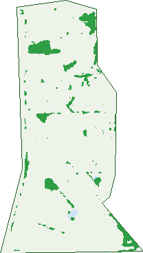
Green: 10 m cells where trees dominate, satellite 2021. Blue: water. The line is the suburb boundary.
| Canopy share, 1 m canopy height map, 2020 | 6.2% |
|---|---|
| Land with trees, 10 m satellite map, 2021 | 5.7% |
Demographics
Unemployment 5% · Labour-force participation 76.7%
Population by age in Atwell
| 0-4 | 540 |
|---|---|
| 5-14 | 1,502 |
| 15-19 | 808 |
| 20-24 | 653 |
| 25-34 | 1,056 |
| 35-44 | 1,471 |
| 45-54 | 1,630 |
| 55-64 | 904 |
| 65-74 | 474 |
| 75-84 | 207 |
| 85+ | 42 |
Dwelling types in Atwell
| House | 2,846 |
|---|---|
| Townhouse | 43 |
| Apartment | 124 |
| Other | 0 |
Households by weekly income in Atwell
| <$650 | 198 |
|---|---|
| $650-1,499 | 566 |
| $1,500-2,999 | 940 |
| $3,000+ | 1,012 |
Top ancestries in Atwell
| English | 3,585 |
|---|---|
| Australian | 3,147 |
| Other | 1,149 |
| Scottish | 907 |
| Chinese | 800 |
| Irish | 707 |
Housing tenure in Atwell
| Owned | 660 |
|---|---|
| Mortgage | 1,630 |
| Rented | 690 |
| Other | 19 |
Cars per household in Atwell
| 0 | 61 |
|---|---|
| 1 | 805 |
| 2 | 1,324 |
| 3 | 516 |
| 4+ | 286 |
Commute to work in Atwell
| Car | 3,617 |
|---|---|
| Train | 225 |
| Bus | 50 |
| Tram/ferry | 0 |
| Walked | 35 |
| Bicycle | 9 |
| Home | 355 |
Top countries of birth in Atwell
| England | 629 |
|---|---|
| New Zealand | 263 |
| China | 242 |
| Malaysia | 179 |
| South Africa | 175 |
| India | 164 |
Languages used at home in Atwell
| Mandarin | 458 |
|---|---|
| Cantonese | 106 |
| Korean | 106 |
| Indonesian | 69 |
| Persian | 68 |
| Spanish | 58 |
Birds & Wildlife Nearby
26,210 bird observations recorded near Atwell — most often seen:
- Pacific Black Duck (1,403)
- Australian White Ibis (1,381)
- Black Swan (1,335)
- White-faced Heron (1,171)
- Australian Shelduck (1,163)
- Australian Raven (1,090)
- Grey Teal (1,008)
- South-western Australian Magpie (974)
- Willie Wagtail (940)
- Whistling Kite (934)
- Rainbow Lorikeet (913)
- Splendid Fairy-wren (896)
- Australian Pelican (836)
Show all 30 birds recorded near Atwell
- Little Pied Cormorant (821)
- Western Australian Raven (809)
- Red Wattlebird (801)
- Eurasian Coot (763)
- Swamp Harrier (759)
- Red-capped Parrot (736)
- Great Egret (721)
- Straw-necked Ibis (721)
- Musk Duck (715)
- Silvereye (690)
- Welcome Swallow (679)
- South-western Grey Fantail (669)
- Western Splendid Fairy-wren (667)
- Southern Willie Wagtail (662)
- Australasian Purple Swamphen (657)
- New Holland Honeyeater (651)
- Australian Magpie (645)
Sightings reported by observers, not a survey, so the counts show what people record rather than what lives here. Source: Atlas of Living Australia.
Nearby Suburbs
The closest suburbs to Atwell:
- Success (1.4 km)
- Banjup (2.3 km)
- Aubin Grove (2.7 km)
- Treeby (2.7 km)
- Cockburn Central (2.8 km)
- Hammond Park (3.4 km)
- Jandakot (4.1 km)
- South Lake (4.7 km)
Embed this suburb
Add this free Atwell stat card to your own site — just copy the code:
Preview:
Cite this page
Quoting these figures? Copy the credit line:
Keep an eye on Atwell
One email when this data meaningfully changes — new census figures, prices, rankings. No spam, unsubscribe anytime.
Streets
- Affable Way (27)
- Affinity Way (4)
- Alliance Entrance (13)
- Angelica Way (20)
- Aromatic Crescent (18)
- Aurora Drive (91)
- Avon Crescent (37)
- Barcroft Court (13)
- Bartram Road (67)
- Beenyup Road (67)
- Bendee Drive (14)
- Beswick Gardens (14)
- Bodella Gardens (25)
- Bosci Court (13)
- Bree Close (14)
- Brenchley Drive (113)
- Buss Way (5)
- Calder Way (20)
- Calero Court (6)
- Callistemon Approach (14)
- Carlhausen Close (26)
- Charm Way (23)
- Chase Mews (5)
- Cherub Terrace (14)
- Chimera Terrace (13)
- Chivalry Way (49)
- Chorus Circle (16)
- Clarity Elbow (18)
- Concord Terrace (43)
- Congenial Loop (65)
- Connolly Mews (16)
- Cranshaw Mews (15)
- Cukela Loop (21)
- Daley Close (15)
- Delton Way (58)
- Dionysus Terrace (14)
- Dreier Court (25)
- Dryandra Elbow (19)
- Dulcet Link (24)
- Dunnage Court (18)
- Dusenberg Mews (19)
- Elemi Bend (22)
- Empress Crescent (19)
- Entente Terrace (16)
- Essence Bend (16)
- Esteem Lane (3)
- Euphony Way (8)
- Falke Court (5)
- Fellowship Link (17)
- Flourish Loop (134)
- Folland Parade (91)
- Freshwater Drive (34)
- Gibbs Road (6)
- Gilbride Cove (20)
- Goodwill Avenue (16)
- Halcyon Way (34)
- Haring Green (21)
- Harmony Avenue (60)
- Harvest Lakes Boulevard (29)
- Haven Way (10)
- Hawkesbury Retreat (31)
- Hayton Mews (11)
- Heath Close (1)
- Hedges Retreat (36)
- Hoult Mews (10)
- Hygeia Bend (6)
- Jakovich Circuit (32)
- Jenkin Mews (17)
- Jenniphur Court (17)
- Jerrat Mews (24)
- Jouissance Bend (30)
- Justice Link (28)
- Kanji Loop (25)
- Kennack Vista (44)
- Kinship Way (8)
- Kurrajong Approach (13)
- Lakehurst Way (30)
- Lanao Way (17)
- Ledgard Cross (4)
- Ling Court (7)
- Lipton Mews (27)
- Lombe Gardens (34)
- Lory Mews (3)
- Lydon Boulevard (120)
- Lyon Road (73)
- Mahogany Loop (33)
- Marich Cove (19)
- Marie Court (11)
- Mayhew Cross (24)
- Mcguckin Close (2)
- Minyon Circuit (18)
- Molloy Circuit (70)
- Mosedale Retreat (26)
- Mystic Elbow (14)
- Naylor Close (9)
- Neroli Link (12)
- O'farrell Close (14)
- Oaten Retreat (11)
- Optima Bend (4)
- Pacific Avenue (14)
- Paperbark Lane (22)
- Paradise Grove (9)
- Patchouli Circle (33)
- Pindan Elbow (25)
- Poso Place (27)
- Providence Link (13)
- Quong Place (14)
- Radiance Link (10)
- Ranson Lane (7)
- Rendell Avenue (10)
- Repose Terrace (9)
- Reynardson Avenue (6)
- Rosehill Court (14)
- Rossell Place (15)
- Sanguine Way (34)
- Sedge Link (12)
- Serene Bend (16)
- Shadwell Retreat (29)
- Solace Gardens (28)
- Sorell Way (9)
- St Claire Gardens (36)
- Strand Close (25)
- Tapper Road (68)
- Tiberias Rise (13)
- Tinsley Close (2)
- Torr Court (2)
- Touchell Retreat (13)
- Tourner Retreat (18)
- Tozer Loop (18)
- Tranquil Gardens (20)
- Turnbull Close (23)
- Tylee Cove (13)
- Unity Way (51)
- Veneta Circuit (38)
- Vetiver Link (17)
- Wah Court (15)
- Walters Retreat (14)
- Waters Avenue (12)
- Wilmot Close (3)
- Windchime Terrace (34)
- Wisdom Lane (22)
- Woodhead Way (4)
- Woolmore Cross (33)
- Zodiac Loop (15)