Warragul VIC 3820
13,355 addresses · 538 streets
Monash Electorate › Baw Baw LGA › Warragul · 93 km from Melbourne
📦 Thinking of moving here? Read the Warragul moving guide

Living Here
A growing regional town in Victoria's West Gippsland, Warragul serves a rich dairy district within commuting reach of Melbourne. Households average 2.5 people and the median age is 40. Median household income is $1,563 a week, with rent around $321.
Warragul is a suburb of Victoria, home to about 19,856 people, with a median age of 40. The typical household earns around $1,563 a week, with median rent near $321 a week. Most homes are houses. About 76% of households own their home and 23% rent. Most workers drive to work. Common community backgrounds include English, Australian, Scottish. On the ABS socio-economic scale it sits in decile 5 of 10 nationally — a mid-range area. The median house sells for about $640,000.
Over time — Census 2001 → 2021
Dashed line: district figures for the Warragul statistical area (SA2), the smallest area the ABS published before 2011. Solid line: Warragul itself.
Getting Around & Local Services
3 supermarkets
2 Catholic churches
2 pharmacies
4 doctors & medical clinics
2 physiotherapists
1 optometrist
3 childcare & kindergartens
1 library
1 post office
1 golf club
1 playground
2 plumbers
Getting around. Train station: Warragul, 1.1 km south · Airport: Latrobe Valley Airport, 47.2 km east.
Sport & Recreation
21 facilities recorded in Warragul, the first 10 below.
- Baxter Reserve Soccer
- Braha Martial Arts & Fitness Centre Fitness / Gymnasium Workouts, Martial Arts
- Brooker Park Australian Rules Football, Soccer
- Burke St Criterium Circuit Cycling
- Eastern Park Australian Rules Football, Cricket
- EC Leeson Pavillion Badminton
- Feel Good Fitness Fitness / Gymnasium Workouts
- Fitness 101 Fitness / Gymnasium Workouts
- Geoff Watt Track Athletics, Soccer
- Logan Park Australian Rules Football, Badminton, Cricket, Equestrian
Socio-economic Standing
Deciles from 1 (lowest) to 10 (highest), against all Australian suburbs. The overall figure weighs advantage and disadvantage together; economic resources counts income and housing, and education & jobs counts qualifications and occupation. They often differ. Source: ABS SEIFA 2021.
Median Sale Prices
Median of recorded sales in the period, not a valuation. Source: Victorian Property Sales Report, Land Use Victoria.
Tree cover
🌳 Tree canopy: 9.3% share of land under canopy · satellite map, 2020
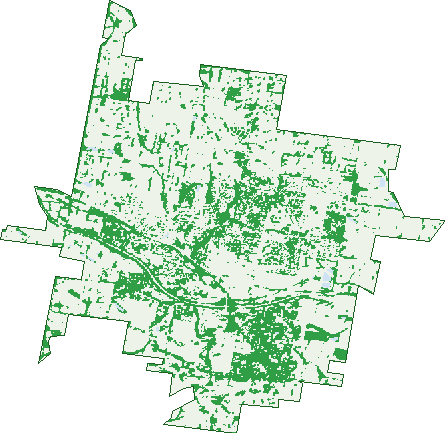
Green: 10 m cells where trees dominate, satellite 2021. Blue: water. The line is the suburb boundary.
| Canopy share, 1 m canopy height map, 2020 | 9.3% |
|---|---|
| Land with trees, 10 m satellite map, 2021 | 27.7% |
Demographics
Unemployment 4% · Labour-force participation 59.3%
Population by age in Warragul
| 0-4 | 1,229 |
|---|---|
| 5-14 | 2,410 |
| 15-19 | 1,117 |
| 20-24 | 1,080 |
| 25-34 | 2,685 |
| 35-44 | 2,299 |
| 45-54 | 2,376 |
| 55-64 | 2,379 |
| 65-74 | 2,263 |
| 75-84 | 1,444 |
| 85+ | 573 |
Dwelling types in Warragul
| House | 6,591 |
|---|---|
| Townhouse | 389 |
| Apartment | 318 |
| Other | 189 |
Households by weekly income in Warragul
| <$650 | 1,258 |
|---|---|
| $650-1,499 | 2,144 |
| $1,500-2,999 | 2,281 |
| $3,000+ | 1,337 |
Top ancestries in Warragul
| English | 8,523 |
|---|---|
| Australian | 7,868 |
| Scottish | 2,405 |
| Irish | 2,398 |
| Other | 1,414 |
| Ancestry NS | 1,037 |
Housing tenure in Warragul
| Owned | 2,794 |
|---|---|
| Mortgage | 2,805 |
| Rented | 1,685 |
| Other | 126 |
Cars per household in Warragul
| 0 | 361 |
|---|---|
| 1 | 2,545 |
| 2 | 2,978 |
| 3 | 968 |
| 4+ | 574 |
Commute to work in Warragul
| Car | 6,326 |
|---|---|
| Train | 38 |
| Bus | 21 |
| Tram/ferry | 0 |
| Walked | 176 |
| Bicycle | 22 |
| Home | 1,324 |
Top countries of birth in Warragul
| England | 678 |
|---|---|
| New Zealand | 218 |
| India | 194 |
| Netherlands | 131 |
| Scotland | 91 |
| Germany | 90 |
Languages used at home in Warragul
| Mandarin | 168 |
|---|---|
| Punjabi | 86 |
| Italian | 67 |
| Sinhalese | 58 |
| Vietnamese | 57 |
| Hindi | 50 |
Birds & Wildlife Nearby
4,912 bird observations recorded near Warragul — most often seen:
- Common Starling (284)
- Eurasian Blackbird (283)
- Australian Magpie (273)
- Australian Wood Duck (265)
- Pacific Black Duck (254)
- Australian White Ibis (252)
- Common Myna (247)
- Magpie-lark (225)
- Spotted Turtle-dove (216)
- Little Raven (177)
- House Sparrow (168)
- Little Corella (154)
- Red Wattlebird (154)
Show all 30 birds recorded near Warragul
- Australasian Purple Swamphen (146)
- Chestnut Teal (145)
- Rainbow Lorikeet (142)
- Superb Fairy-wren (140)
- Eurasian Coot (139)
- Masked Lapwing (128)
- Grey Fantail (125)
- Galah (112)
- Welcome Swallow (111)
- Eastern Rosella (106)
- Little Wattlebird (105)
- Laughing Kookaburra (103)
- Pied Currawong (102)
- New Holland Honeyeater (91)
- White-faced Heron (90)
- Southern Victoria Australian Magpie (88)
- Brown Thornbill (87)
Sightings reported by observers, not a survey, so the counts show what people record rather than what lives here. Source: Atlas of Living Australia.
Nearby Suburbs
The closest suburbs to Warragul:
- Nilma (3.6 km)
- Drouin East (4.3 km)
- Lillico (4.3 km)
- Warragul West (4.5 km)
- Bona Vista (6 km)
- Brandy Creek (6.3 km)
- Nilma North (6.4 km)
- Buln Buln (6.4 km)
Embed this suburb
Add this free Warragul stat card to your own site — just copy the code:
Preview:
Cite this page
Quoting these figures? Copy the credit line:
Keep an eye on Warragul
One email when this data meaningfully changes — new census figures, prices, rankings. No spam, unsubscribe anytime.
Streets
- Abbey Court (9)
- Aberdeen Street (6)
- Acacia Court (11)
- Affleck Street (31)
- Alaska Court (13)
- Albert Road (143)
- Albert Street (109)
- Albion Court (10)
- Alday Place (3)
- Alder Place (7)
- Alexander Street (37)
- Alford Street (37)
- Alfred Street (73)
- Alida Court (7)
- Alluvial Lane (4)
- Amber Place (7)
- Ambrose Court (6)
- Anderson Street (7)
- Angus Court (10)
- Archee Road (22)
- Archibald Crescent (46)
- Armadale Drive (31)
- Armours Road (64)
- Arthurs Drive (13)
- Ascott Street (11)
- Asha Court (21)
- Ashdown Drive (33)
- Aspect Way (13)
- Atkinson Court (11)
- Audra Place (10)
- Avon Street (20)
- Bagot Street (18)
- Bailey Road (35)
- Balharrie Court (11)
- Ballast Drive (25)
- Balmoral Street (7)
- Banksia Street (51)
- Barkly Street (16)
- Barton Court (11)
- Baw Baw Drive (20)
- Beckham Court (8)
- Bell Heather Boulevard (13)
- Bell Park Close (22)
- Bella Vista Drive (31)
- Bellamy Close (10)
- Bentley Street (23)
- Berkeley Court (5)
- Betula Court (6)
- Biram Drive (58)
- Birch Court (11)
- Blackman Drive (11)
- Bladen Street (25)
- Blaxland Crescent (8)
- Bloomfield Road (1)
- Blue Gum Drive (6)
- Blue Jacket Drive (8)
- Bluebell Street (1)
- Bluegum Drive (6)
- Bluestone Court (6)
- Boab Street (5)
- Bona Vista Road (36)
- Boronia Street (28)
- Botanica Drive (40)
- Bowen Street (207)
- Boxcar Street (17)
- Boyd Avenue (30)
- Bradley Place (9)
- Brandy Creek Road (198)
- Brentwood Court (16)
- Bronte Avenue (2)
- Brooks Court (10)
- Brunton Retreat (24)
- Buckland Drive (26)
- Buln Buln Road (1)
- Buntine Drive (18)
- Bunya Street (12)
- Burke Street (144)
- Burnett Close (5)
- Burton Street (66)
- Burvill Court (6)
- Butlers Track (7)
- Cadby Court (19)
- Cambridge Drive (27)
- Camelot Court (34)
- Canawindi Drive (22)
- Cantona Court (7)
- Carisbrooke Drive (34)
- Carriage Drive (67)
- Casmil Court (9)
- Cason Crescent (50)
- Castlefield Court (20)
- Cataraqui Court (21)
- Caton Street (32)
- Cattlemans Drive (6)
- Cazalys Road (2)
- Cedar Place (5)
- Cedarwood Drive (15)
- Celtic Avenue (2)
- Centre Avenue (27)
- Centrepoint Arcade (6)
- Champion Road (21)
- Charles Street (76)
- Chelsea Court (13)
- Cheltenham Drive (13)
- Cherrywood Place (12)
- Chesterfield Avenue (25)
- Christies Road (4)
- Church Street (24)
- Churchill Street (18)
- Civic Place (1)
- Claremont Drive (28)
- Clifford Street (133)
- Clover Court (4)
- Club Lane (3)
- Colin Street (12)
- Colman Street (32)
- Colquhoun Boulevard (29)
- Connor Street (16)
- Cook Street (9)
- Coolabah Court (3)
- Copelands Road (81)
- Coral Court (5)
- Cornish Street (12)
- Correa Court (9)
- Coventry Drive (18)
- Craig Street (20)
- Crole Drive (80)
- Cromie Drive (31)
- Cromwell Road (10)
- Cullen Street (17)
- Cumberland Avenue (14)
- Cunningham Court (9)
- Cyclops Street (9)
- Dallas Court (17)
- Dalmuir Court (27)
- Dalton Court (11)
- Danes Road (7)
- Darling Street (20)
- Davey Street (6)
- Davies Street (5)
- Davine Street (14)
- Dawson Drive (75)
- Deakin Court (11)
- Denbeigh Court (6)
- Denton Drive (18)
- Derwent Drive (5)
- Derwent Street (22)
- Dollarburn Road (25)
- Domain Court (7)
- Downton Street (18)
- Drift Road (12)
- Duncan Close (2)
- Dundee Street (11)
- Dunn Street (28)
- Durack Court (23)
- Eade Avenue (28)
- Earl Court (9)
- East West Road (86)
- Ebony Court (8)
- Edgerton Street (17)
- Edinburgh Street (15)
- Eisenhower Street (19)
- Elizabeth Street (20)
- Ellen Close (21)
- Elm Court (10)
- Elmside Avenue (11)
- Elska Court (11)
- Emberwood Road (111)
- Emerald Drive (13)
- Endeavour Street (21)
- English Drive (39)
- Eve Road (13)
- Excelsior Road (6)
- Eyre Place (3)
- Farrington Close (7)
- Fenton Street (25)
- Fernery Boulevard (24)
- Fieldstone Avenue (18)
- Fir Place (8)
- Francis Way (4)
- Frangipani Court (16)
- Franklin Avenue (40)
- Friend Street (17)
- Galloway Street (4)
- Garabaldi Street (42)
- Gardiner Court (10)
- Garrett Street (11)
- Gay Court (6)
- Gemstone Court (12)
- George Street (31)
- Gibbo Road (2)
- Gibson Road (34)
- Gladstone Street (34)
- Glendalough Close (5)
- Glendon Drive (32)
- Glenhuntly Court (13)
- Glory Avenue (23)
- Gloucester Place (38)
- Golden Avenue (21)
- Grange Crescent (70)
- Greendale Court (3)
- Grevillea Court (12)
- Grosvenor Court (9)
- Gwinear Court (9)
- Hadlow Street (13)
- Hallyburton Grove (26)
- Hamilton Drive (22)
- Hampton Drive (23)
- Harbinger Street (3)
- Hart Drive (36)
- Hartford Avenue (17)
- Hastings Square (32)
- Hawkesburn Court (13)
- Haworth Road (3)
- Hayes Drive (32)
- Hazel Drive (55)
- Heartwell Street (17)
- Heathland Avenue (16)
- Henderlyn Retreat (5)
- Henley Avenue (18)
- Henrietta Street (25)
- Henry Court (10)
- Henshall Street (40)
- Herbert Street (12)
- Heysen Rise (14)
- Hibiscus Court (11)
- Hickory Street (5)
- Highclere Street (12)
- Highland Way (15)
- Highvale Rise (39)
- Hillandale Road (18)
- Hillgrove Close (22)
- Holly Street (7)
- Holmfield Court (5)
- Hooleys Road (2)
- Hope Street (8)
- Howard Street (38)
- Howitt Street (12)
- Hume Court (8)
- Hunter Crescent (13)
- Huntingfield Court (18)
- Hyde Court (13)
- Ida Court (7)
- Inverness Street (7)
- Ironbark Street (6)
- Islington Court (5)
- Ista Street (26)
- Jacaranda Court (12)
- Jacob Court (16)
- James Court (7)
- Jamieson Street (43)
- Janette Close (33)
- Jarrah Crescent (45)
- Jasmine Court (22)
- Jerdan Place (9)
- June Court (30)
- Karen Court (4)
- Kauri Street (4)
- Kendal Avenue (27)
- Kensington Drive (29)
- Kent Street (67)
- Kewell Court (5)
- Kilfera Court (10)
- Killarney Lane (51)
- Kimberley Court (7)
- King Street (76)
- Kingsley Rise (3)
- Kingston Street (10)
- Kokoda Street (15)
- Kookaburra Court (13)
- Koonung Drive (8)
- Koroit Street (32)
- Korumburra-warragul Road (56)
- Kurrajong Road (61)
- Lancashire Road (17)
- Landsborough Street (25)
- Lantana Avenue (16)
- Lardners Track (36)
- Larkones Court (12)
- Latrobe Street (118)
- Lawson Crescent (36)
- Leichardt Court (11)
- Lewisham Court (9)
- Ley Street (2)
- Ligar Street (18)
- Lilleys Road (61)
- Lillico Road (37)
- Lillypilly Avenue (28)
- Lillypilly Street (31)
- Limestone Court (32)
- Lincoln Street (7)
- Lindy Court (12)
- Lochfyne Close (8)
- Loddon Court (8)
- Logan Street (15)
- Longmuir Road (5)
- Longview Road (33)
- Lonsdale Court (6)
- Lovell Drive (37)
- Lowe Place (7)