Upwey VIC 3158
2,958 addresses · 101 streets
Casey Electorate › Yarra Ranges LGA › Upwey · 34 km from Melbourne
📦 Thinking of moving here? Read the Upwey moving guide

Living Here
Upwey is a suburb of Victoria, home to about 6,818 people, with a median age of 41. The typical household earns around $2,171 a week, with median rent near $390 a week. Most homes are houses. About 90% of households own their home and 10% rent. Most workers drive to work. Common community backgrounds include English, Australian, Irish. On the ABS socio-economic scale it sits in decile 9 of 10 nationally — a relatively advantaged area. The median house sells for about $861,000.
Over time — Census 2001 → 2021
Dashed line: district figures for the Upwey - Tecoma statistical area (SA2), the smallest area the ABS published before 2011. Solid line: Upwey itself.
Getting Around & Local Services
3 supermarkets
1 Catholic church
1 pharmacy
1 physiotherapist
2 optometrists
2 libraries
2 post offices
2 golf clubs
2 playgrounds
4 beauty salons
Getting around. Train station: Upwey, 350 m north · Railway halt: Selby, 3.7 km east · Bus interchange: Boronia Station, 6.6 km north-west · Airport: Moorabbin Airport, 21.8 km west.
Sport & Recreation
2 facilities recorded in Upwey.
- Upwey Reserve Australian Rules Football, Cricket, Lawn Bowls, Tennis (Outdoor)
- Upwey South Reserve Netball, Tennis (Outdoor)
Socio-economic Standing
Deciles from 1 (lowest) to 10 (highest), against all Australian suburbs. The overall figure weighs advantage and disadvantage together; economic resources counts income and housing, and education & jobs counts qualifications and occupation. They often differ. Source: ABS SEIFA 2021.
Median Sale Prices
Median of recorded sales in the period, not a valuation. Source: Victorian Property Sales Report, Land Use Victoria.
Tree cover
🌳 Tree canopy: 59.4% share of land under canopy · satellite map, 2020
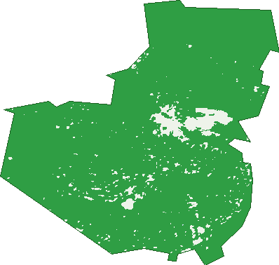
Green: 10 m cells where trees dominate, satellite 2021. Blue: water. The line is the suburb boundary.
| Canopy share, 1 m canopy height map, 2020 | 59.4% |
|---|---|
| Land with trees, 10 m satellite map, 2021 | 96.6% |
Demographics
Unemployment 3.8% · Labour-force participation 70.5%
Population by age in Upwey
| 0-4 | 396 |
|---|---|
| 5-14 | 918 |
| 15-19 | 421 |
| 20-24 | 359 |
| 25-34 | 744 |
| 35-44 | 962 |
| 45-54 | 1,044 |
| 55-64 | 971 |
| 65-74 | 721 |
| 75-84 | 222 |
| 85+ | 56 |
Dwelling types in Upwey
| House | 2,374 |
|---|---|
| Townhouse | 9 |
| Apartment | 24 |
| Other | 0 |
Households by weekly income in Upwey
| <$650 | 252 |
|---|---|
| $650-1,499 | 533 |
| $1,500-2,999 | 813 |
| $3,000+ | 689 |
Top ancestries in Upwey
| English | 3,136 |
|---|---|
| Australian | 2,652 |
| Irish | 990 |
| Scottish | 819 |
| Other | 570 |
| German | 369 |
Housing tenure in Upwey
| Owned | 847 |
|---|---|
| Mortgage | 1,290 |
| Rented | 231 |
| Other | 18 |
Cars per household in Upwey
| 0 | 55 |
|---|---|
| 1 | 582 |
| 2 | 1,117 |
| 3 | 397 |
| 4+ | 237 |
Commute to work in Upwey
| Car | 1,963 |
|---|---|
| Train | 48 |
| Bus | 7 |
| Tram/ferry | 6 |
| Walked | 43 |
| Bicycle | 4 |
| Home | 1,043 |
Top countries of birth in Upwey
| England | 354 |
|---|---|
| New Zealand | 101 |
| Netherlands | 59 |
| Germany | 52 |
| South Africa | 40 |
| India | 39 |
Languages used at home in Upwey
| Mandarin | 35 |
|---|---|
| Italian | 28 |
| Russian | 27 |
| German | 26 |
| Spanish | 26 |
| French | 21 |
Birds & Wildlife Nearby
115,327 bird observations recorded near Upwey — most often seen:
- Sulphur-crested Cockatoo (7,493)
- Crimson Rosella (7,274)
- Australian Magpie (6,360)
- Brown Thornbill (6,059)
- Laughing Kookaburra (6,027)
- Little Raven (4,856)
- Eurasian Blackbird (4,822)
- Rainbow Lorikeet (4,664)
- Pied Currawong (4,516)
- Red Wattlebird (4,503)
- Grey Fantail (4,308)
- Eastern Yellow Robin (4,058)
- Grey Butcherbird (3,577)
Show all 30 birds recorded near Upwey
- Australian King-parrot (3,469)
- Noisy Miner (3,427)
- White-browed Scrubwren (3,398)
- Superb Lyrebird (3,162)
- Galah (3,103)
- Common Myna (3,076)
- Superb Fairy-wren (2,807)
- Eastern Spinebill (2,783)
- White-throated Treecreeper (2,664)
- Australian Wood Duck (2,655)
- Eastern Rosella (2,509)
- Magpie-lark (2,490)
- Grey Shrike-thrush (2,375)
- Spotted Turtle-dove (2,320)
- Silvereye (2,250)
- Pacific Black Duck (2,168)
- Common Starling (2,154)
Sightings reported by observers, not a survey, so the counts show what people record rather than what lives here. Source: Atlas of Living Australia.
Nearby Suburbs
The closest suburbs to Upwey:
- Tecoma (1.3 km)
- Upper Ferntree Gully (2.1 km)
- Belgrave (2.2 km)
- Tremont (2.4 km)
- Belgrave Heights (2.6 km)
- Ferny Creek (3.1 km)
- Belgrave South (3.9 km)
- Selby (4 km)
Embed this suburb
Add this free Upwey stat card to your own site — just copy the code:
Preview:
Cite this page
Quoting these figures? Copy the credit line:
Keep an eye on Upwey
One email when this data meaningfully changes — new census figures, prices, rankings. No spam, unsubscribe anytime.
Streets
- Acacia Avenue (43)
- Alexander Avenue (113)
- Alpine Avenue (18)
- Austral Avenue (16)
- Bayview Avenue (66)
- Belbrook Road (36)
- Belmont Avenue (82)
- Birdwood Avenue (33)
- Blackwood Street (4)
- Blue Gum Court (9)
- Brooking Street (29)
- Brookside Street (15)
- Brunning Street (11)
- Burwood Highway (58)
- Callandra Wynd (5)
- Carween Avenue (5)
- Cecil Court (7)
- Centre Road (44)
- Chosen Avenue (8)
- Collier Avenue (2)
- Creekbank Street (12)
- Darling Avenue (21)
- Day Street (6)
- Dealbata Road (23)
- Deans Road (51)
- Douglas Street (16)
- Durang Road (15)
- Earl Street (32)
- Effie Avenue (18)
- Elliott Road (2)
- Eloera Street (14)
- Ferguson Street (68)
- Ferndale Avenue (43)
- Ferndale Road (4)
- Fernery Road (14)
- Florence Avenue (27)
- Forest Park Road (72)
- Gerratts Avenue (8)
- Glenfern Avenue (58)
- Glenfern Close (5)
- Glenfern Road (208)
- Godber Court (11)
- Griffiths Road (74)
- Guy Street (1)
- Henderson Street (1)
- Highcliff Road (27)
- Hillside Grove (21)
- Hughes Street (70)
- Hume Street (81)
- Ievers Street (6)
- Irvine Street (10)
- Kaye Road (13)
- Kemp Street (15)
- Kia Ora Avenue (16)
- Kookaburra Dell (11)
- Kooringal Road (72)
- Kumbada Avenue (24)
- Leah Avenue (28)
- Leonard Street (51)
- Lilian Street (14)
- Mahony Street (84)
- Main Street (97)
- Marchant Avenue (1)
- Mary Street (28)
- Mast Gully Road (105)
- Matson Drive (14)
- Mclaren Street (14)
- Melaleuca Drive (39)
- Morris Road (138)
- Oakdale Road (12)
- Oakland Avenue (23)
- Old Belgrave Road (48)
- Olivette Avenue (1)
- Palmer Street (4)
- Photinia Court (8)
- Pioneer Avenue (14)
- Riley Road (10)
- Rita Street (14)
- Roma Parade (20)
- Ropley Grange (42)
- Royal Street (10)
- Rutherford Road (1)
- Sayers Road (11)
- St Kilda Avenue (20)
- Stanhope Street (14)
- Tasman Avenue (8)
- Ternes Road (76)
- The Avenue (24)
- The Highway (14)
- Thompson Road (63)
- Toorac Road (15)
- Toorourrong Road (2)
- Torry Hill Road (42)
- Trevor Street (4)
- View Street (13)
- Warra Road (12)
- Waverley Street (1)
- Weldon Grove (6)
- Woodleigh Avenue (3)
- Wright Avenue (34)
- Yeronga Avenue (2)