Thomastown VIC 3074
12,710 addresses · 364 streets
Scullin Electorate › Whittlesea LGA › Thomastown · 15 km from Melbourne
📦 Thinking of moving here? Read the Thomastown moving guide

Living Here
An established, multicultural outer-northern Melbourne suburb with an industrial base, Thomastown is affordable and rail-connected. Households average 2.6 people and the median age is 39. Median household income is $1,225 a week, with rent around $350.
Thomastown is a suburb of Victoria, home to about 20,234 people, with a median age of 39. The typical household earns around $1,225 a week, with median rent near $350 a week. Most homes are houses. About 69% of households own their home and 29% rent. Most workers drive to work. Common community backgrounds include Italian, Australian, English. On the ABS socio-economic scale it sits in decile 2 of 10 nationally — a more disadvantaged area. The median house sells for about $720,000.
Over time — Census 2001 → 2021
Dashed line: district figures for the Thomastown statistical area (SA2), the smallest area the ABS published before 2011. Solid line: Thomastown itself.
Getting Around & Local Services
50 schools
3 physiotherapists
1 playground
2 beauty salons
2 electricians
1 carpenter
Getting around. Train station: Thomastown, 200 m north-east · Tram stop: Stop 67: Bundoora Square Shopping Centre, 4.4 km east · Bus interchange: Epping Plaza Shopping Centre, 3.4 km north · Airport: Essendon Fields Airport, 11.1 km south-west.
Sport & Recreation
10 facilities recorded in Thomastown.
- AMF Keon Park Ten Pin Bowling
- Five Star Fitness Centre 24/7 Gym Aerobics, Fitness / Gymnasium Workouts
- HR Uren Reserve Soccer
- Main Street Reserve Australian Rules Football, Cricket
- Nick Ascenzo Reserve Open Space
- RGC Cook Reserve Soccer
- Thomas Street Reserve Bocce, Soccer
- Thomastown East Reserve Cricket, Soccer, Tennis (Outdoor)
- Thomastown Indoor Sports Beach Volleyball, Cricket (Indoor), Netball, Soccer (Indoor Soccer / Futsal)
- Thomastown Recreation & Aquatic Centre Aerobics, Boxing, Fitness / Gymnasium Workouts, Netball (Indoor), Swimming
Socio-economic Standing
Deciles from 1 (lowest) to 10 (highest), against all Australian suburbs. The overall figure weighs advantage and disadvantage together; economic resources counts income and housing, and education & jobs counts qualifications and occupation. They often differ. Source: ABS SEIFA 2021.
Median Sale Prices
Median of recorded sales in the period, not a valuation. Source: Victorian Property Sales Report, Land Use Victoria.
Tree cover
🌳 Tree canopy: 2.7% share of land under canopy · satellite map, 2020
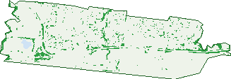
Green: 10 m cells where trees dominate, satellite 2021. Blue: water. The line is the suburb boundary.
| Canopy share, 1 m canopy height map, 2020 | 2.7% |
|---|---|
| Land with trees, 10 m satellite map, 2021 | 6.2% |
Demographics
Unemployment 8% · Labour-force participation 49.9%
Population by age in Thomastown
| 0-4 | 1,121 |
|---|---|
| 5-14 | 2,035 |
| 15-19 | 996 |
| 20-24 | 1,334 |
| 25-34 | 3,221 |
| 35-44 | 2,679 |
| 45-54 | 2,222 |
| 55-64 | 2,219 |
| 65-74 | 2,269 |
| 75-84 | 1,599 |
| 85+ | 543 |
Dwelling types in Thomastown
| House | 6,192 |
|---|---|
| Townhouse | 699 |
| Apartment | 445 |
| Other | 3 |
Households by weekly income in Thomastown
| <$650 | 1,641 |
|---|---|
| $650-1,499 | 2,492 |
| $1,500-2,999 | 1,986 |
| $3,000+ | 784 |
Top ancestries in Thomastown
| Other | 5,187 |
|---|---|
| Italian | 2,798 |
| Australian | 2,304 |
| English | 1,945 |
| Macedonian | 1,899 |
| Greek | 1,547 |
Housing tenure in Thomastown
| Owned | 3,135 |
|---|---|
| Mortgage | 1,842 |
| Rented | 2,105 |
| Other | 130 |
Cars per household in Thomastown
| 0 | 666 |
|---|---|
| 1 | 2,903 |
| 2 | 2,469 |
| 3 | 802 |
| 4+ | 394 |
Commute to work in Thomastown
| Car | 5,029 |
|---|---|
| Train | 279 |
| Bus | 54 |
| Tram/ferry | 0 |
| Walked | 81 |
| Bicycle | 29 |
| Home | 1,131 |
Top countries of birth in Thomastown
| India | 1,258 |
|---|---|
| Italy | 1,201 |
| North Macedonia | 1,105 |
| Vietnam | 1,062 |
| Greece | 827 |
| China | 396 |
Languages used at home in Thomastown
| Arabic | 1,990 |
|---|---|
| Macedonian | 1,569 |
| Vietnamese | 1,535 |
| Italian | 1,503 |
| Greek | 1,297 |
| Punjabi | 787 |
Birds & Wildlife Nearby
96,252 bird observations recorded near Thomastown — most often seen:
- Rainbow Lorikeet (6,401)
- Little Raven (6,377)
- Common Myna (6,288)
- Noisy Miner (5,641)
- Red Wattlebird (5,052)
- Magpie-lark (4,704)
- Australian Magpie (4,668)
- Spotted Turtle-dove (4,346)
- Eurasian Blackbird (4,039)
- Common Starling (3,896)
- Crested Pigeon (3,782)
- Rock Dove (3,486)
- Silver Gull (3,133)
Show all 30 birds recorded near Thomastown
- Welcome Swallow (2,952)
- Australian White Ibis (2,771)
- Pacific Black Duck (2,540)
- Dusky Moorhen (2,490)
- Eurasian Coot (2,196)
- Grey Butcherbird (2,078)
- Australian Wood Duck (2,065)
- Australasian Purple Swamphen (2,005)
- Sulphur-crested Cockatoo (1,968)
- Galah (1,908)
- Southern Victoria Australian Magpie (1,860)
- White-plumed Honeyeater (1,847)
- Little Pied Cormorant (1,668)
- House Sparrow (1,542)
- Little Corella (1,540)
- Chestnut Teal (1,529)
- Little Wattlebird (1,480)
Sightings reported by observers, not a survey, so the counts show what people record rather than what lives here. Source: Atlas of Living Australia.
Nearby Suburbs
The closest suburbs to Thomastown:
Embed this suburb
Add this free Thomastown stat card to your own site — just copy the code:
Preview:
Cite this page
Quoting these figures? Copy the credit line:
Keep an eye on Thomastown
One email when this data meaningfully changes — new census figures, prices, rankings. No spam, unsubscribe anytime.
Streets
- Acacia Street (18)
- Aden Court (3)
- Ainwick Crescent (11)
- Alchester Court (22)
- Alexander Avenue (239)
- Alfred Avenue (16)
- Alison Street (22)
- Almond Court (8)
- Alvarado Avenue (76)
- Apex Court (26)
- Ardoch Avenue (27)
- Arndell Street (73)
- Arugula Circuit (19)
- Ascot Court (6)
- Ash Street (20)
- Ashley Court (9)
- Austarc Avenue (18)
- Avalon Way (4)
- Avenel Court (8)
- Avoca Street (18)
- Aylward Avenue (37)
- Aztec Place (6)
- Badger Court (10)
- Balcombe Court (24)
- Banksia Avenue (46)
- Barbara Court (13)
- Barcelona Close (10)
- Barden Place (8)
- Bargrove Court (12)
- Barry Road (155)
- Bates Avenue (53)
- Baxter Court (10)
- Beech Street (12)
- Belah Street (15)
- Bella Court (6)
- Bendigo Crescent (46)
- Beno Court (9)
- Bickley Avenue (118)
- Blair Court (11)
- Blaxland Avenue (20)
- Boronia Street (11)
- Bostock Court (33)
- Brand Drive (101)
- Bridgewater Grove (19)
- Brock Street (67)
- Brookland Grove (38)
- Buckingham Court (9)
- Burwood Court (10)
- Calypso Place (5)
- Cambridge Court (11)
- Campus Place (11)
- Cardiff Street (14)
- Caroline Street (62)
- Carrington Boulevard (94)
- Catalina Drive (36)
- Cedar Street (150)
- Centofanti Place (13)
- Central Avenue (74)
- Chaffey Street (30)
- Chantal Close (8)
- Chapman Avenue (32)
- Chappell Street (93)
- Charles Street (29)
- Charlton Place (16)
- Charnfield Court (43)
- Chateau Court (11)
- Chelsea Court (19)
- Cherston Court (10)
- Chesney Court (13)
- Cipora Place (10)
- Clarke Street (66)
- Clay Court (23)
- Cleveland Street (35)
- Cliveden Court (18)
- Clover Court (8)
- Colac Place (6)
- Collins Street (8)
- Comalco Court (13)
- Commercial Drive (102)
- Como Court (10)
- Coonawarra Drive (32)
- Cranley Place (12)
- Creek View (10)
- Crispian Court (14)
- Cumberland Crescent (56)
- Currajong Street (80)
- Dakota Drive (25)
- Dalton Road (206)
- Darebin Drive (130)
- Delta Court (15)
- Delwyn Close (21)
- Dent Court (7)
- Derwent Court (11)
- Diplomat Drive (19)
- Domata Street (18)
- Dorothy Avenue (36)
- Douglas Court (16)
- Drysdale Court (8)
- Dunstans Court (106)
- Earlwood Court (16)
- Edgars Road (208)
- Edgewood Close (17)
- Edna Street (51)
- Edwards Street (12)
- Elder Court (8)
- Elm Street (18)
- Emma Court (14)
- Endeavour Avenue (9)
- Equator Road (9)
- Everett Court (16)
- Falcon Street (39)
- Fernshaw Street (56)
- Fiesta Court (21)
- Fig Terrace (49)
- Finch Street (7)
- Fir Street (6)
- Flight Court (10)
- Foster Court (9)
- Frederick Street (44)
- French Street (65)
- Gardenia Road (41)
- Geoffrey Street (24)
- German Court (8)
- Gladstone Street (48)
- Glebe Place (6)
- Glenburn Street (25)
- Glenhaven Court (16)
- Goodyear Drive (57)
- Graham Court (23)
- Grasidi Lane (8)
- Green Street (60)
- Greenhills Road (3)
- Greenstone Court (13)
- Grovedale Close (12)
- Gunbower Close (6)
- Gunsynd Close (15)
- Hakea Court (14)
- Hall Court (8)
- Hampstead Court (21)
- Hampton Court (7)
- Hanrahan Street (33)
- Harbard Street (2)
- Harding Street (35)
- Harley Court (18)
- Hartville Court (12)
- Hawkesbury Court (21)
- Hazel Avenue (32)
- Heany Court (21)
- Heath Street (5)
- Heather Avenue (46)
- Heron Court (6)
- Heyington Avenue (166)
- High Street (284)
- Highlands Road (86)
- Holt Parade (87)
- Honniball Drive (57)
- Horne Street (8)
- Howe Court (8)
- Industrial Avenue (36)
- Inglewood Drive (23)
- Ivanhoe Court (23)
- Jacob Court (8)
- Johnson Street (19)
- Juniper Crescent (33)
- Kalorama Place (17)
- Karingal Way (45)
- Katrina Court (13)
- Kemp Avenue (41)
- Kenneth Street (2)
- Kensington Court (10)
- Keon Parade (81)
- Kerang Place (14)
- Kingsley Court (28)
- Kingston Close (7)
- Lansell Court (24)
- Lantana Avenue (38)
- Lara Close (5)
- Larch Street (54)
- Latitude Boulevard (74)
- Lawson Crescent (45)
- Leila Court (22)
- Leilani Grove (20)
- Lena Court (10)
- Leslie Street (24)
- Liberty Place (9)
- Lilydale Court (10)
- Lincoln Drive (81)
- Lindley Court (10)
- Linton Drive (34)
- Lionel Street (2)
- Lipton Drive (88)
- Lira Court (12)
- Lisa Court (6)
- Lockwood Grove (38)
- Loddon Court (17)
- Lois Court (12)
- Longview Court (45)
- Lucknow Crescent (38)
- Macquarie Drive (96)
- Madera Drive (31)
- Mahoneys Road (159)
- Main Street (255)
- Maitland Close (13)
- Manton Court (8)
- Marcia Street (51)
- Maritana Crescent (47)
- Marjory Street (31)
- Marlock Close (13)
- Maryland Close (15)
- Matlock Court (8)
- Mckimmies Road (2)
- Mckinnon Street (15)
- Mcleod Street (35)
- Mcphee Court (13)
- Meagan Close (20)
- Melaleuca Drive (49)
- Mercedes Drive (41)
- Merchant Avenue (29)
- Michelle Close (11)
- Michigan Terrace (20)
- Middle Court (15)
- Midholm Court (35)
- Milford Street (11)
- Millgrove Avenue (20)
- Milne Street (13)
- Miriam Street (19)
- Mockridge Drive (2)
- Moonah Court (10)
- Mount View Road (113)
- Mulga Street (51)
- Murchison Way (40)
- Mustang Lane (7)
- Myrtle Street (18)
- Natalie Court (12)
- Neerim Street (12)
- Nevin Drive (37)
- Newhaven Street (16)
- Newton Street (71)
- Noel Court (7)
- Norlane Court (6)
- Norman Grove (5)
- Northey Close (9)
- Northgate Drive (153)
- Norwich Avenue (37)
- Nottingham Crescent (54)
- Nottingham Road (1)
- Oakdale Place (8)
- Olinda Close (6)
- Omega Court (16)
- Ostia Court (30)
- Owen Court (10)
- Oxford Drive (58)
- Oxheart Street (6)
- Palm Street (31)
- Pamela Court (7)
- Pandora Avenue (118)
- Parklands Drive (87)
- Pasture Place (9)
- Patrick Street (10)
- Patrona Street (23)
- Pelmet Crescent (29)
- Philip Court (15)
- Pine Street (53)
- Pinewood Drive (60)
- Pioneer Court (19)
- Pipaki Drive (2)
- Plane Street (55)
- Platinum Street (13)
- Plato Court (9)
- Pleasant Road (101)
- Poplar Street (71)
- Portland Place (3)
- Prime Street (42)
- Quandong Street (40)
- Queenscliff Road (77)
- Raywood Court (13)
- Redfern Close (6)
- Regal Avenue (46)
- Richardson Street (50)
- Rimfire Close (8)
- Riviera Court (12)
- Robinvale Avenue (32)
- Rochester Drive (54)
- Roma Court (11)
- Rose Court (7)
- Rowen Street (1)
- Rupert Court (6)
- Rustic Court (13)
- Ryegrass Close (11)
- Ryegrass Place (11)
- Ryland Place (11)
- Salamander Avenue (26)
- Salisbury Street (17)
- San Marzano Street (9)
- Scott Street (7)
- Senna Court (18)
- Settlement Road (426)
- Seville Close (8)
- Sheffield Court (15)
- Sheila Court (10)