Tawonga VIC 3697
383 addresses · 32 streets
Indi Electorate › Alpine LGA › Tawonga · 231 km from Melbourne

Living Here
Tawonga is a suburb of Victoria, home to about 568 people, with a median age of 52. The typical household earns around $1,375 a week, with median rent near $220 a week. Most homes are houses. About 93% of households own their home and 7% rent. Most workers drive to work. Common community backgrounds include English, Australian, Scottish. On the ABS socio-economic scale it sits in decile 6 of 10 nationally — a mid-range area.
Over time — Census 2001 → 2021
Dashed line: district figures for the Bright - Mount Beauty statistical area (SA2), the smallest area the ABS published before 2011. Solid line: Tawonga itself.
Getting Around & Local Services
1 school
1 park
1 Catholic church
1 hospital
1 library
1 golf club
Getting around. Airport: Porepunkah Airport, 23.6 km west.
Sport & Recreation
1 facility recorded in Tawonga.
- Tawonga Bowls Club Lawn Bowls
Socio-economic Standing
Deciles from 1 (lowest) to 10 (highest), against all Australian suburbs. The overall figure weighs advantage and disadvantage together; economic resources counts income and housing, and education & jobs counts qualifications and occupation. They often differ. Source: ABS SEIFA 2021.
Tree cover
🌳 Tree canopy: 58.1% share of land under canopy · satellite map, 2020
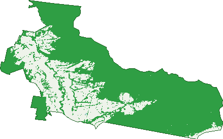
Green: 10 m cells where trees dominate, satellite 2021. Blue: water. The line is the suburb boundary.
| Canopy share, 1 m canopy height map, 2020 | 58.1% |
|---|---|
| Land with trees, 10 m satellite map, 2021 | 71.7% |
Demographics
Unemployment 1.9% · Labour-force participation 55.1%
Population by age in Tawonga
| 0-4 | 23 |
|---|---|
| 5-14 | 66 |
| 15-19 | 33 |
| 20-24 | 19 |
| 25-34 | 38 |
| 35-44 | 59 |
| 45-54 | 75 |
| 55-64 | 124 |
| 65-74 | 102 |
| 75-84 | 35 |
| 85+ | 13 |
Dwelling types in Tawonga
| House | 223 |
|---|---|
| Townhouse | 0 |
| Apartment | 0 |
| Other | 0 |
Households by weekly income in Tawonga
| <$650 | 53 |
|---|---|
| $650-1,499 | 71 |
| $1,500-2,999 | 66 |
| $3,000+ | 32 |
Top ancestries in Tawonga
| English | 259 |
|---|---|
| Australian | 206 |
| Scottish | 92 |
| Irish | 85 |
| Other | 44 |
| German | 34 |
Housing tenure in Tawonga
| Owned | 120 |
|---|---|
| Mortgage | 75 |
| Rented | 15 |
| Other | 0 |
Cars per household in Tawonga
| 0 | 6 |
|---|---|
| 1 | 50 |
| 2 | 103 |
| 3 | 37 |
| 4+ | 28 |
Commute to work in Tawonga
| Car | 147 |
|---|---|
| Train | 0 |
| Bus | 0 |
| Tram/ferry | 0 |
| Walked | 3 |
| Bicycle | 0 |
| Home | 55 |
Top countries of birth in Tawonga
| England | 19 |
|---|---|
| Canada | 5 |
| New Zealand | 5 |
| Philippines | 5 |
| Thailand | 5 |
| Germany | 3 |
Languages used at home in Tawonga
| German | 3 |
|---|
Birds & Wildlife Nearby
1,901 bird observations recorded near Tawonga — most often seen:
- House Sparrow (136)
- Eastern Australian Magpie (97)
- Northern Superb Fairy-wren (97)
- South-eastern Crimson Rosella (89)
- Southern Laughing Kookaburra (85)
- Common Starling (81)
- Southern Satin Bowerbird (77)
- Eurasian Blackbird (76)
- Southern Willie Wagtail (69)
- South-eastern White-browed Scrubwren (67)
- Tasmanian Grey Fantail (64)
- Crimson Rosella (63)
- Eastern Red Wattlebird (58)
Show all 30 birds recorded near Tawonga
- Southern Australian King-parrot (58)
- Southern Red-browed Finch (57)
- South-eastern Yellow-faced Honeyeater (56)
- Laughing Kookaburra (52)
- Grey Fantail (51)
- South-east Eastern Spinebill (51)
- Australian King-parrot (49)
- Eastern Galah (49)
- Eastern Grey Shrike-thrush (49)
- Pied Currawong (49)
- Superb Fairy-wren (49)
- Yellow-faced Honeyeater (48)
- Southern Magpie-lark (47)
- Australian Wood Duck (45)
- Eastern Australian Raven (45)
- Eastern Sulphur-crested Cockatoo (44)
- Australian Magpie (43)
Sightings reported by observers, not a survey, so the counts show what people record rather than what lives here. Source: Atlas of Living Australia.
Nearby Suburbs
The closest suburbs to Tawonga:
- Tawonga South (4.9 km)
- Mount Beauty (5.8 km)
- Coral Bank (8.9 km)
- Mongans Bridge (12.5 km)
- Germantown (13.3 km)
- Bogong (14.3 km)
- Freeburgh (14.3 km)
- Smoko (16.5 km)
Embed this suburb
Add this free Tawonga stat card to your own site — just copy the code:
Preview:
Cite this page
Quoting these figures? Copy the credit line:
Keep an eye on Tawonga
One email when this data meaningfully changes — new census figures, prices, rankings. No spam, unsubscribe anytime.
Streets
- Antonio Close (5)
- Charles Street (24)
- Cooper Street (18)
- Costantino Lane (2)
- Costantinos Lane (3)
- Cottrells Lane (4)
- Cuthbert Street (7)
- Damms Road (14)
- Diggings Road (13)
- Drummond Street (6)
- Fieldings Road (5)
- Fredas Lane (4)
- Gould Court (7)
- Hores Lane (19)
- Kellers Road (6)
- Kiewa Valley Highway (133)
- Lambert Street (7)
- Loudens Lane (2)
- Miles Road (3)
- Mount York Road (5)
- Mountain Creek Road (41)
- Plantation Lane (4)
- Red Bank Road (1)
- Redbank Mongans Road (2)
- Reids Lane (14)
- Ronald Street (10)
- Ropers Road (3)
- Ryder Spur Track (1)
- Ryders Lane (16)
- Sullivans Lane (1)
- Tawonga Gap Road (1)
- Toms Road (2)