Stony Creek VIC 3371
17 addresses · 7 streets
Mallee Electorate › Central Goldfields LGA › Stony Creek · 131 km from Melbourne

Getting Around & Local Services
2 golf clubs
Socio-economic Standing
Deciles from 1 (lowest) to 10 (highest), against all Australian suburbs. The overall figure weighs advantage and disadvantage together; economic resources counts income and housing, and education & jobs counts qualifications and occupation. They often differ. Source: ABS SEIFA 2021.
Tree cover
🌳 Tree canopy: 45.2% share of land under canopy · satellite map, 2020
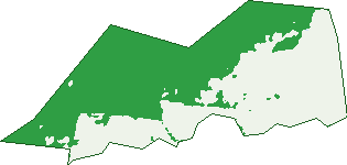
Green: 10 m cells where trees dominate, satellite 2021. Blue: water. The line is the suburb boundary.
| Canopy share, 1 m canopy height map, 2020 | 45.2% |
|---|---|
| Land with trees, 10 m satellite map, 2021 | 52.9% |
Demographics
Top ancestries in Stony Creek
| Australian | 5 |
|---|---|
| Aboriginal | 0 |
| Chinese | 0 |
| Croatian | 0 |
| Dutch | 0 |
| English | 0 |
Commute to work in Stony Creek
| Car | 0 |
|---|---|
| Train | 0 |
| Bus | 0 |
| Tram/ferry | 0 |
| Walked | 3 |
| Bicycle | 0 |
| Home | 0 |
Birds & Wildlife Nearby
4,171 bird observations recorded near Stony Creek — most often seen:
- Eastern Red Wattlebird (260)
- Eastern Weebill (255)
- Eastern Grey Shrike-thrush (229)
- South-eastern Brown-headed Honeyeater (220)
- South-eastern White-throated Treecreeper (206)
- Coastal Spotted Pardalote (199)
- South Australian Buff-rumped Thornbill (186)
- Southern Victoria Australian Magpie (165)
- Eastern White-winged Chough (156)
- Western Yellow-tufted Honeyeater (155)
- South-eastern Grey Fantail (153)
- Southern Fuscous Honeyeater (143)
- Northern Superb Fairy-wren (142)
Show all 30 birds recorded near Stony Creek
- Australian Magpie (138)
- South-eastern Brown Treecreeper (135)
- Eastern Striated Pardalote (134)
- Southern Rufous Whistler (126)
- Eastern Scarlet Robin (121)
- South-east Eastern Rosella (108)
- Mainland Black-faced Cuckoo-shrike (103)
- Eastern Australian Raven (100)
- Mistletoebird (94)
- South-eastern Striated Thornbill (94)
- South-eastern Yellow-faced Honeyeater (94)
- Diamond Firetail (77)
- South-eastern Golden Whistler (77)
- Black-chinned Honeyeater (eastern) (76)
- Long-billed Corella (76)
- Red Wattlebird (75)
- South-eastern Musk Lorikeet (74)
Sightings reported by observers, not a survey, so the counts show what people record rather than what lives here. Source: Atlas of Living Australia.
Nearby Suburbs
The closest suburbs to Stony Creek:
Embed this suburb
Add this free Stony Creek stat card to your own site — just copy the code:
Preview:
Cite this page
Quoting these figures? Copy the credit line:
Keep an eye on Stony Creek
One email when this data meaningfully changes — new census figures, prices, rankings. No spam, unsubscribe anytime.
Streets
- Bucklands Lane (1)
- Davies Road (5)
- Hull Lane (1)
- Nuggetty Gully Road (1)
- Old Ballarat Road (3)
- Stoney Creek Track (5)
- Wighton Lane (1)