Southbank VIC 3006
35,460 addresses · 48 streets
Macnamara Electorate › Melbourne LGA › Southbank · 1 km from Melbourne
📦 Thinking of moving here? Read the Southbank moving guide

Living Here
Just across the Yarra from Melbourne's CBD, Southbank is a vertical, apartment-led neighbourhood. Residents skew young — a median age of 31 — in small households of 1.8, and incomes are high at $1,926 a week. Median rent runs about $411.
Southbank is a suburb of Victoria, home to about 22,631 people, with a median age of 31. The typical household earns around $1,926 a week, with median rent near $411 a week. Most homes are apartments. About 31% of households own their home and 68% rent. Most workers work from home. Common community backgrounds include Chinese, English, Australian. On the ABS socio-economic scale it sits in decile 10 of 10 nationally — a relatively advantaged area.
Over time — Census 2001 → 2021
Dashed line: district figures for the Southbank statistical area (SA2), the smallest area the ABS published before 2011. Solid line: Southbank itself.
Getting Around & Local Services
25 childcare & kindergartens
1 dog park
Getting around. Train station: Flinders Street, 850 m north-east · Tram stop: Stop 116: City Road, 200 m south-west · Bus interchange: Southern Cross Coach Terminal, 1.3 km north-west · Ferry wharf: Crown Landing, 550 m north-west · Airport: Essendon Fields Airport, 12.4 km north-west.
Socio-economic Standing
Deciles from 1 (lowest) to 10 (highest), against all Australian suburbs. The overall figure weighs advantage and disadvantage together; economic resources counts income and housing, and education & jobs counts qualifications and occupation. They often differ. Source: ABS SEIFA 2021.
Median Sale Prices
Median of recorded sales in the period, not a valuation. Source: Victorian Property Sales Report, Land Use Victoria.
Tree cover
🌳 Tree canopy: 3.1% share of land under canopy · satellite map, 2020
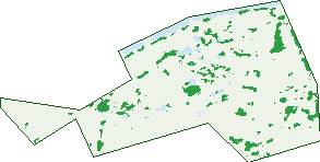
Green: 10 m cells where trees dominate, satellite 2021. Blue: water. The line is the suburb boundary.
| Canopy share, 1 m canopy height map, 2020 | 3.1% |
|---|---|
| Land with trees, 10 m satellite map, 2021 | 4.1% |
Demographics
Unemployment 5.8% · Labour-force participation 77.7%
Population by age in Southbank
| 0-4 | 693 |
|---|---|
| 5-14 | 651 |
| 15-19 | 454 |
| 20-24 | 2,853 |
| 25-34 | 9,417 |
| 35-44 | 4,209 |
| 45-54 | 1,741 |
| 55-64 | 1,313 |
| 65-74 | 870 |
| 75-84 | 358 |
| 85+ | 65 |
Dwelling types in Southbank
| House | 3 |
|---|---|
| Townhouse | 158 |
| Apartment | 11,686 |
| Other | 9 |
Households by weekly income in Southbank
| <$650 | 1,352 |
|---|---|
| $650-1,499 | 2,872 |
| $1,500-2,999 | 4,408 |
| $3,000+ | 2,801 |
Top ancestries in Southbank
| Other | 5,256 |
|---|---|
| Chinese | 4,683 |
| English | 4,109 |
| Australian | 2,785 |
| Indian | 2,212 |
| Ancestry NS | 1,545 |
Housing tenure in Southbank
| Owned | 1,497 |
|---|---|
| Mortgage | 2,103 |
| Rented | 7,969 |
| Other | 205 |
Cars per household in Southbank
| 0 | 4,762 |
|---|---|
| 1 | 5,930 |
| 2 | 933 |
| 3 | 79 |
| 4+ | 32 |
Commute to work in Southbank
| Car | 2,572 |
|---|---|
| Train | 458 |
| Bus | 65 |
| Tram/ferry | 1,312 |
| Walked | 2,007 |
| Bicycle | 230 |
| Home | 6,320 |
Top countries of birth in Southbank
| India | 2,127 |
|---|---|
| China | 2,024 |
| Malaysia | 829 |
| England | 677 |
| New Zealand | 610 |
| Indonesia | 604 |
Languages used at home in Southbank
| Mandarin | 2,622 |
|---|---|
| Spanish | 1,208 |
| Hindi | 903 |
| Cantonese | 702 |
| Indonesian | 478 |
| Korean | 461 |
Birds & Wildlife Nearby
630,248 bird observations recorded near Southbank — most often seen:
- Common Myna (41,334)
- Rainbow Lorikeet (35,298)
- Silver Gull (33,370)
- Magpie-lark (32,184)
- Rock Dove (31,929)
- Little Raven (30,544)
- Red Wattlebird (29,230)
- Noisy Miner (28,689)
- Australian Magpie (24,360)
- Spotted Turtle-dove (23,893)
- Pacific Black Duck (23,488)
- Dusky Moorhen (22,608)
- Eurasian Blackbird (22,483)
Show all 30 birds recorded near Southbank
- Welcome Swallow (19,605)
- Eurasian Coot (19,359)
- Common Starling (18,656)
- House Sparrow (18,030)
- Australasian Purple Swamphen (16,943)
- Chestnut Teal (16,377)
- Pied Currawong (14,605)
- Willie Wagtail (14,459)
- Little Pied Cormorant (13,879)
- White-plumed Honeyeater (13,307)
- Black Swan (13,133)
- Australian Wood Duck (13,006)
- Little Wattlebird (12,463)
- Bell Miner (12,410)
- Grey Butcherbird (11,667)
- Crested Pigeon (11,576)
- Australasian Grebe (11,363)
Sightings reported by observers, not a survey, so the counts show what people record rather than what lives here. Source: Atlas of Living Australia.
Nearby Suburbs
The closest suburbs to Southbank:
- Melbourne (0.8 km)
- South Melbourne (0.9 km)
- South Wharf (1.2 km)
- Docklands (1.7 km)
- West Melbourne (2.2 km)
- Albert Park (2.3 km)
- East Melbourne (2.3 km)
- Port Melbourne (2.7 km)
Embed this suburb
Add this free Southbank stat card to your own site — just copy the code:
Preview:
Cite this page
Quoting these figures? Copy the credit line:
Keep an eye on Southbank
One email when this data meaningfully changes — new census figures, prices, rankings. No spam, unsubscribe anytime.
Streets
- Bale Circuit (519)
- Ballantyne Street (7)
- Balston Street (1,418)
- Blakeney Place (2)
- Catherine Street (157)
- Cecil Street (23)
- Chessell Street (22)
- City Road (10,285)
- Clarendon Street (1,270)
- Clarke Street (1,045)
- Cook Street (30)
- Coventry Street (1,187)
- Dodds Street (232)
- Dorcas Street (1,434)
- Douglas Street (6)
- Fanning Street (6)
- Fawkner Street (17)
- Ferrars Street (25)
- Freshwater Place (611)
- Gladstone Street (26)
- Grant Street (10)
- Haig Street (1,018)
- Hancock Street (294)
- Hoff Boulevard (675)
- Kavanagh Street (4,624)
- Kings Way (21)
- Market Street (44)
- Meaden Street (15)
- Miles Street (74)
- Montague Street (7)
- Moore Street (15)
- Moray Street (200)
- Munro Street (2)
- Normanby Road (490)
- Power Street (395)
- Queens Bridge Street (2,222)
- Queensbridge Square (249)
- Railway Place (2)
- Riverside Quay (1,051)
- Southbank Boulevard (1,751)
- Southgate Avenue (567)
- St Kilda Road (427)
- Sturt Street (1,087)
- Wadey Street (8)
- Walker Street (3)
- Wells Place (2)
- Wells Street (476)
- Whiteman Street (1,409)