Rutherglen VIC 3685
1,914 addresses · 117 streets
Indi Electorate › Indigo LGA › Rutherglen · 237 km from Melbourne
📦 Thinking of moving here? Read the Rutherglen moving guide

Living Here
Rutherglen is a suburb of Victoria, home to about 2,579 people, with a median age of 48. The typical household earns around $1,306 a week, with median rent near $250 a week. Most homes are houses. About 79% of households own their home and 19% rent. Most workers drive to work. Common community backgrounds include English, Australian, Irish. On the ABS socio-economic scale it sits in decile 3 of 10 nationally — a more disadvantaged area. The median house sells for about $550,000.
Over time — Census 2001 → 2021
Dashed line: district figures for the Rutherglen statistical area (SA2), the smallest area the ABS published before 2011. Solid line: Rutherglen itself.
Getting Around & Local Services
1 supermarket
1 Catholic church
1 pharmacy
1 medical clinic
1 hospital
1 childcare centre
1 library
2 service stations
2 golf clubs
1 playground
2 bakeries
Getting around. Airport: Corowa Aerodrome, 12.3 km north-west.
Sport & Recreation
5 facilities recorded in Rutherglen.
- Barkley Park Australian Rules Football, Cricket, Netball
- Rutherglen Golf Course/ Bowls Club Golf, Lawn Bowls
- Rutherglen Outdoor Pool Swimming
- Rutherglen recreation reserve Cricket, Hockey, soccer
- Rutherglen Tennis Club Tennis (Outdoor)
Socio-economic Standing
Deciles from 1 (lowest) to 10 (highest), against all Australian suburbs. The overall figure weighs advantage and disadvantage together; economic resources counts income and housing, and education & jobs counts qualifications and occupation. They often differ. Source: ABS SEIFA 2021.
Median Sale Prices
Median of recorded sales in the period, not a valuation. Source: Victorian Property Sales Report, Land Use Victoria.
Tree cover
🌳 Tree canopy: 4.6% share of land under canopy · satellite map, 2020
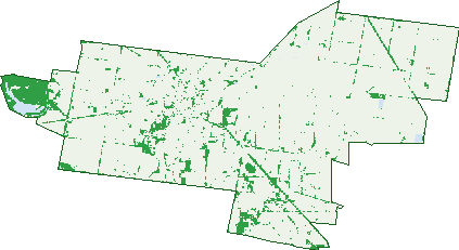
Green: 10 m cells where trees dominate, satellite 2021. Blue: water. The line is the suburb boundary.
| Canopy share, 1 m canopy height map, 2020 | 4.6% |
|---|---|
| Land with trees, 10 m satellite map, 2021 | 9.6% |
Demographics
Unemployment 3.3% · Labour-force participation 56.4%
Population by age in Rutherglen
| 0-4 | 125 |
|---|---|
| 5-14 | 305 |
| 15-19 | 141 |
| 20-24 | 97 |
| 25-34 | 255 |
| 35-44 | 267 |
| 45-54 | 314 |
| 55-64 | 381 |
| 65-74 | 398 |
| 75-84 | 214 |
| 85+ | 81 |
Dwelling types in Rutherglen
| House | 966 |
|---|---|
| Townhouse | 63 |
| Apartment | 0 |
| Other | 13 |
Households by weekly income in Rutherglen
| <$650 | 203 |
|---|---|
| $650-1,499 | 338 |
| $1,500-2,999 | 300 |
| $3,000+ | 106 |
Top ancestries in Rutherglen
| English | 1,182 |
|---|---|
| Australian | 1,097 |
| Irish | 413 |
| Scottish | 335 |
| German | 159 |
| Ancestry NS | 117 |
Housing tenure in Rutherglen
| Owned | 445 |
|---|---|
| Mortgage | 359 |
| Rented | 197 |
| Other | 22 |
Cars per household in Rutherglen
| 0 | 36 |
|---|---|
| 1 | 341 |
| 2 | 372 |
| 3 | 172 |
| 4+ | 103 |
Commute to work in Rutherglen
| Car | 828 |
|---|---|
| Train | 0 |
| Bus | 0 |
| Tram/ferry | 0 |
| Walked | 48 |
| Bicycle | 7 |
| Home | 126 |
Top countries of birth in Rutherglen
| England | 64 |
|---|---|
| New Zealand | 37 |
| Netherlands | 16 |
| Germany | 13 |
| Scotland | 8 |
| South Africa | 6 |
Languages used at home in Rutherglen
| Italian | 9 |
|---|---|
| German | 4 |
| Greek | 3 |
| Filipino | 3 |
Birds & Wildlife Nearby
10,970 bird observations recorded near Rutherglen — most often seen:
- Australian Magpie (522)
- Pacific Black Duck (518)
- Common Starling (495)
- Magpie-lark (495)
- Welcome Swallow (495)
- Grey Teal (465)
- Crested Pigeon (453)
- Red-rumped Parrot (437)
- Galah (401)
- Masked Lapwing (396)
- White-faced Heron (391)
- White-plumed Honeyeater (388)
- Willie Wagtail (386)
Show all 30 birds recorded near Rutherglen
- Eastern Rosella (383)
- Noisy Miner (381)
- Superb Fairy-wren (377)
- Australasian Grebe (372)
- Australian Wood Duck (362)
- Eurasian Coot (360)
- House Sparrow (339)
- Straw-necked Ibis (304)
- Australian Raven (292)
- Little Pied Cormorant (277)
- Black Swan (264)
- Australian White Ibis (262)
- White-necked Heron (241)
- Black-faced Cuckoo-shrike (235)
- Eurasian Blackbird (234)
- Dusky Moorhen (227)
- Yellow-billed Spoonbill (218)
Sightings reported by observers, not a survey, so the counts show what people record rather than what lives here. Source: Atlas of Living Australia.
Nearby Suburbs
The closest suburbs to Rutherglen:
- Carlyle (6 km)
- Wahgunyah (7.5 km)
- Lilliput (8.6 km)
- Cornishtown (10.7 km)
- Norong (11.1 km)
- Gooramadda (11.6 km)
- Chiltern Valley (12.8 km)
- Browns Plains (15 km)
Embed this suburb
Add this free Rutherglen stat card to your own site — just copy the code:
Preview:
Cite this page
Quoting these figures? Copy the credit line:
Keep an eye on Rutherglen
One email when this data meaningfully changes — new census figures, prices, rankings. No spam, unsubscribe anytime.
Streets
- Alice Street (22)
- Alluvial Street (14)
- Anderson Lane (1)
- Audley Street (13)
- Bandy Circuit (17)
- Barkly Street (49)
- Battery Road (12)
- Booth Street (11)
- Bowling Green Lane (1)
- Burgoynes Road (3)
- Burt Court (5)
- Butler Street (3)
- Campbell Street (27)
- Carlyle Court (5)
- Chiltern Valley Road (4)
- Chiltern-rutherglen Road (12)
- Church Street (32)
- Clare Court (5)
- Clydesdale Road (17)
- Cooper Court (9)
- Cornishtown Road (7)
- Culbertson Street (22)
- Cullens Lane (1)
- Deas Lane (2)
- Diffey Street (5)
- Douglas Street (60)
- Drummond Street (11)
- Eyre Street (17)
- Falkiners Lane (1)
- Federation Way (3)
- Federli Street (1)
- Fortune Street (52)
- Gills Road (1)
- Glasgow Street (25)
- Golling Street (3)
- Gollings Street (3)
- Gooramadda Road (6)
- Grails Road (5)
- Granthams Road (1)
- Great Northern Road (2)
- Great Southern Road (7)
- Green Lane (2)
- Greybox Court (5)
- Hamilton Street (8)
- Harris Street (27)
- Hayseed Drive (12)
- Herbert Street (48)
- Herrins Road (3)
- High Street (199)
- Hogans Road (1)
- Holmes Court (7)
- Hopetoun Road (34)
- Howlong Road (54)
- Humphreys Road (8)
- Hunter Street (69)
- Jacaranda Avenue (9)
- Jacks Road (5)
- James Court (12)
- Jones Road (2)
- Kilborn Road (4)
- Killeens Road (4)
- King Street (5)
- Kings Road (4)
- Lake Moodemere Road (2)
- Lemin Avenue (2)
- Lord Street (10)
- Main Street (159)
- Main Street W (9)
- Maunayne Court (8)
- Mcdonald Road (4)
- Mcinnes Road (1)
- Meehan Street (30)
- Melvilles Road (2)
- Millers Lane (3)
- Moodemere Road (3)
- Moodemere Street (27)
- Murphy Street (40)
- Murray Street (90)
- Murray Valley Highway (19)
- Muscat Court (21)
- Nashs Road (26)
- Nesbitt Road (1)
- Nilsson Street (4)
- Nott Street (7)
- Parkins Road (3)
- Pearces Road (1)
- Pipeclay Court (8)
- Racecourse Road (1)
- Ready Street (100)
- Redgum Place (9)
- Reeve Street (3)
- Regent Street (3)
- Reid Street (85)
- Research Station Lane (2)
- Riesling Road (12)
- Romey Place (7)
- Romey Street (8)
- Rosewood Court (6)
- Rutherglen-springhurst Road (4)
- Rutherglen-wahgunyah Road (2)
- Scott Street (18)
- Sheridan Court (14)
- Sheridans Bridge Road (9)
- Slaughterhouse Road (9)
- Soles Street (19)
- Springhurst Road (2)
- Stillards Lane (2)
- Swift Street (8)
- Taylor Street (22)
- Tommy Mcrae Drive (17)
- Tower Place (15)
- Trimbles Lane (1)
- Waldrons Lane (2)
- Warrens Lane (9)
- Webbs Road (1)
- William Street (24)
- Williamson Road (1)