Robinvale VIC 3549
1,857 addresses · 101 streets
Mallee Electorate › Swan Hill LGA › Robinvale · 408 km from Melbourne
📦 Thinking of moving here? Read the Robinvale moving guide

Living Here
Robinvale is a suburb of Victoria, home to about 3,497 people, with a median age of 36. The typical household earns around $1,317 a week, with median rent near $220 a week. Most homes are houses. About 53% of households own their home and 44% rent. Most workers drive to work. Common community backgrounds include Australian, English, Ancestry NS. On the ABS socio-economic scale it sits in decile 1 of 10 nationally — a more disadvantaged area. The median house sells for about $390,000.
Over time — Census 2001 → 2021
Dashed line: district figures for the Robinvale statistical area (SA2), the smallest area the ABS published before 2011. Solid line: Robinvale itself.
Getting Around & Local Services
3 supermarkets
1 Catholic church
1 pharmacy
1 dentist
1 hospital
2 post offices
2 service stations
1 golf club
1 bakery
1 butcher
2 hardware stores
1 hairdresser
1 plumber
Getting around. Airport: Robinvale Airport, 4.5 km south.
Sport & Recreation
4 facilities recorded in Robinvale.
- Riverside Park Recreation Reserve Australian Rules Football, Cricket, Netball, Rugby League, Tennis (Outdoor)
- Robinvale Golf course Golf
- Robinvale Leisure Centre Badminton, Basketball, Fitness / Gymnasium Workouts, Soccer (Indoor Soccer / Futsal), Swimming, Volleyball
- Robinvale skate park Skating
Socio-economic Standing
Deciles from 1 (lowest) to 10 (highest), against all Australian suburbs. The overall figure weighs advantage and disadvantage together; economic resources counts income and housing, and education & jobs counts qualifications and occupation. They often differ. Source: ABS SEIFA 2021.
Median Sale Prices
Median of recorded sales in the period, not a valuation. Source: Victorian Property Sales Report, Land Use Victoria.
Tree cover
🌳 Tree canopy: 16.5% share of land under canopy · satellite map, 2020
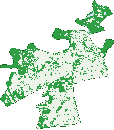
Green: 10 m cells where trees dominate, satellite 2021. Blue: water. The line is the suburb boundary.
| Canopy share, 1 m canopy height map, 2020 | 16.5% |
|---|---|
| Land with trees, 10 m satellite map, 2021 | 40.1% |
Demographics
Unemployment 6.8% · Labour-force participation 53%
Population by age in Robinvale
| 0-4 | 212 |
|---|---|
| 5-14 | 422 |
| 15-19 | 158 |
| 20-24 | 179 |
| 25-34 | 625 |
| 35-44 | 564 |
| 45-54 | 370 |
| 55-64 | 413 |
| 65-74 | 344 |
| 75-84 | 129 |
| 85+ | 74 |
Dwelling types in Robinvale
| House | 872 |
|---|---|
| Townhouse | 26 |
| Apartment | 45 |
| Other | 38 |
Households by weekly income in Robinvale
| <$650 | 206 |
|---|---|
| $650-1,499 | 292 |
| $1,500-2,999 | 265 |
| $3,000+ | 128 |
Top ancestries in Robinvale
| Other | 972 |
|---|---|
| Australian | 563 |
| English | 535 |
| Ancestry NS | 517 |
| Italian | 453 |
| Chinese | 273 |
Housing tenure in Robinvale
| Owned | 307 |
|---|---|
| Mortgage | 206 |
| Rented | 422 |
| Other | 27 |
Cars per household in Robinvale
| 0 | 86 |
|---|---|
| 1 | 280 |
| 2 | 331 |
| 3 | 155 |
| 4+ | 106 |
Commute to work in Robinvale
| Car | 1,051 |
|---|---|
| Train | 0 |
| Bus | 51 |
| Tram/ferry | 0 |
| Walked | 86 |
| Bicycle | 3 |
| Home | 83 |
Top countries of birth in Robinvale
| Malaysia | 425 |
|---|---|
| Vietnam | 195 |
| Thailand | 86 |
| Cambodia | 58 |
| Italy | 50 |
| Philippines | 43 |
Languages used at home in Robinvale
| Vietnamese | 237 |
|---|---|
| Mandarin | 209 |
| Italian | 116 |
| Thai | 82 |
| Khmer | 64 |
| Greek | 38 |
Birds & Wildlife Nearby
6,966 bird observations recorded near Robinvale — most often seen:
- Australian Wood Duck (404)
- Red-rumped Parrot (358)
- Magpie-lark (339)
- Whistling Kite (338)
- Regent Parrot (312)
- Noisy Miner (310)
- Rock Dove (291)
- Galah (289)
- Sulphur-crested Cockatoo (286)
- Yellow Rosella (284)
- Australian Magpie (278)
- Australian Pelican (277)
- Laughing Kookaburra (255)
Show all 30 birds recorded near Robinvale
- White-plumed Honeyeater (233)
- Willie Wagtail (223)
- Common Starling (216)
- Crested Pigeon (216)
- Australian Raven (212)
- Welcome Swallow (186)
- Little Black Cormorant (184)
- Australasian Darter (182)
- Pacific Black Duck (168)
- House Sparrow (157)
- Crimson Rosella (153)
- Eastern Regent Parrot (153)
- Blue-faced Honeyeater (143)
- Great Cormorant (133)
- Tree Martin (132)
- White-faced Heron (129)
- Little Pied Cormorant (125)
Sightings reported by observers, not a survey, so the counts show what people record rather than what lives here. Source: Atlas of Living Australia.
Nearby Suburbs
The closest suburbs to Robinvale:
- Robinvale Irrigation District Section B (2.6 km)
- Robinvale Irrigation District Section D (4.4 km)
- Robinvale Irrigation District Section C (4.6 km)
- Tol Tol (8 km)
- Robinvale Irrigation District Section E (8.1 km)
- Happy Valley (9.4 km)
- Bannerton (13 km)
- Lake Powell (18.4 km)
Embed this suburb
Add this free Robinvale stat card to your own site — just copy the code:
Preview:
Cite this page
Quoting these figures? Copy the credit line:
Keep an eye on Robinvale
One email when this data meaningfully changes — new census figures, prices, rankings. No spam, unsubscribe anytime.
Streets
- Aboriginal Settlement Road (1)
- Adcock Road (8)
- Alexander Street (13)
- Alexishafen Road (12)
- Anniversary Drive (34)
- Anzac Road (14)
- Arafura Street (5)
- Arnott Street (31)
- Balikpapan Road (3)
- Bardia Road (3)
- Benghazi Road (22)
- Bogadjim Road (10)
- Bougainville Road (1)
- Bromley Road (103)
- Buna Road (8)
- Carolyn Court (20)
- Carrazza Court (10)
- Carrington Street (32)
- Cleary Drive (13)
- Coach Road (1)
- Coral Street (2)
- Cramp Road (7)
- Crete Road (21)
- Cuttle Court (4)
- Damascus Road (27)
- Damour Road (25)
- Darwin Road (19)
- Dean Road (5)
- Derna Road (4)
- Donald Street (4)
- El Alamein Road (8)
- Finschhafen Road (17)
- George Street (134)
- Glenda Court (15)
- Gona Road (9)
- Greece Road (2)
- Happy Valley Road (28)
- Herbert Street (39)
- Higgins Road (5)
- Hunt Drive (12)
- Jennifer Court (15)
- Jezzine Road (7)
- Johnson Road (4)
- Kennedy Street (54)
- Kenneth Road (4)
- Kokoda Court (6)
- Lae Road (5)
- Latje Road (134)
- Lawrence Road (2)
- Leonora Street (54)
- Madang Road (12)
- Malaya Road (48)
- Malla Avenue (35)
- Margaret Street (9)
- Mary Court (25)
- Maston Court (7)
- Mccartney Court (2)
- Mclennan Drive (10)
- Milne Bay Road (5)
- Moore Street (52)
- Morris Street (23)
- Murray Valley Highway (28)
- Nadzab Road (8)
- New Britain Road (7)
- New Guinea Road (12)
- Nicholls Street (9)
- Nulty Drive (23)
- Old Street (4)
- Oliver Road (1)
- Parke Street (30)
- Perrin Street (71)
- Pethard Road (14)
- Pump Road (5)
- River Grove (29)
- Robin Street (28)
- Robinvale-sea Lake Road (8)
- Ronald Street (65)
- Rowe Street (31)
- Ryan Road (8)
- Salamaua Road (15)
- Sanananda Road (7)
- Satelberg Road (7)
- Sawka Court (11)
- Shaggy Ridge Road (23)
- Singapore Road (3)
- Smith Road (7)
- Smythe Road (2)
- Spiller Court (6)
- Swan Hill Road (5)
- Tarakan Road (3)
- Timor Road (3)
- Tobruk Road (16)
- Vine Court (10)
- Walsh Road (4)
- Wareo Road (18)
- Warlen Avenue (40)
- Watkin Street (17)
- Weir Road (1)
- Wewak Road (19)
- Williams Road (9)
- Wilson Court (6)