Red Cliffs VIC 3496
3,272 addresses · 194 streets
Mallee Electorate › Mildura LGA › Red Cliffs · 462 km from Melbourne
📦 Thinking of moving here? Read the Red Cliffs moving guide

Living Here
Red Cliffs is a suburb of Victoria, home to about 5,294 people, with a median age of 41. The typical household earns around $1,290 a week, with median rent near $240 a week. Most homes are houses. About 73% of households own their home and 25% rent. Most workers drive to work. Common community backgrounds include Australian, English, Scottish. On the ABS socio-economic scale it sits in decile 2 of 10 nationally — a more disadvantaged area. The median house sells for about $397,500.
Over time — Census 2001 → 2021
Dashed line: district figures for the Red Cliffs statistical area (SA2), the smallest area the ABS published before 2011. Solid line: Red Cliffs itself.
Getting Around & Local Services
3 cafés & restaurants
1 pharmacy
2 doctors & medical clinics
1 childcare centre
1 library
2 post offices
2 service stations
2 gyms & sports centres
1 golf club
2 bakeries
1 butcher
1 beauty salon
Getting around. Airport: Mildura Airport, 13.5 km north-west.
Sport & Recreation
3 facilities recorded in Red Cliffs.
- Quandong Park Australian Rules Football, Baseball, Cricket, Croquet, Netball, Tennis (Outdoor)
- Red Cliffs Bowls Club Lawn Bowls
- Red Cliffs Swimming Pool Swimming
Socio-economic Standing
Deciles from 1 (lowest) to 10 (highest), against all Australian suburbs. The overall figure weighs advantage and disadvantage together; economic resources counts income and housing, and education & jobs counts qualifications and occupation. They often differ. Source: ABS SEIFA 2021.
Median Sale Prices
Median of recorded sales in the period, not a valuation. Source: Victorian Property Sales Report, Land Use Victoria.
Tree cover
🌳 Tree canopy: 5.8% share of land under canopy · satellite map, 2020
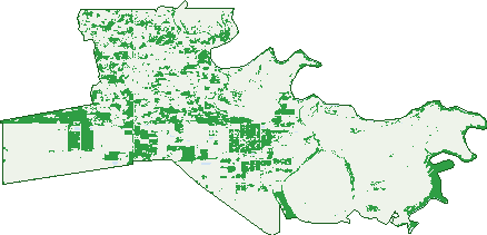
Green: 10 m cells where trees dominate, satellite 2021. Blue: water. The line is the suburb boundary.
| Canopy share, 1 m canopy height map, 2020 | 5.8% |
|---|---|
| Land with trees, 10 m satellite map, 2021 | 21.7% |
Demographics
Unemployment 5.7% · Labour-force participation 55.7%
Population by age in Red Cliffs
| 0-4 | 278 |
|---|---|
| 5-14 | 686 |
| 15-19 | 310 |
| 20-24 | 298 |
| 25-34 | 644 |
| 35-44 | 636 |
| 45-54 | 648 |
| 55-64 | 788 |
| 65-74 | 562 |
| 75-84 | 297 |
| 85+ | 142 |
Dwelling types in Red Cliffs
| House | 1,766 |
|---|---|
| Townhouse | 123 |
| Apartment | 11 |
| Other | 19 |
Households by weekly income in Red Cliffs
| <$650 | 375 |
|---|---|
| $650-1,499 | 626 |
| $1,500-2,999 | 555 |
| $3,000+ | 190 |
Top ancestries in Red Cliffs
| Australian | 2,164 |
|---|---|
| English | 2,052 |
| Scottish | 533 |
| Ancestry NS | 486 |
| Irish | 434 |
| Italian | 352 |
Housing tenure in Red Cliffs
| Owned | 679 |
|---|---|
| Mortgage | 682 |
| Rented | 464 |
| Other | 45 |
Cars per household in Red Cliffs
| 0 | 107 |
|---|---|
| 1 | 575 |
| 2 | 697 |
| 3 | 312 |
| 4+ | 191 |
Commute to work in Red Cliffs
| Car | 1,741 |
|---|---|
| Train | 0 |
| Bus | 20 |
| Tram/ferry | 0 |
| Walked | 53 |
| Bicycle | 5 |
| Home | 194 |
Top countries of birth in Red Cliffs
| England | 79 |
|---|---|
| Malaysia | 76 |
| Italy | 40 |
| India | 37 |
| New Zealand | 30 |
| Philippines | 23 |
Languages used at home in Red Cliffs
| Italian | 68 |
|---|---|
| Mandarin | 44 |
| Punjabi | 31 |
| Turkish | 19 |
| Vietnamese | 18 |
| Thai | 15 |
Birds & Wildlife Nearby
2,357 bird observations recorded near Red Cliffs — most often seen:
- Crested Pigeon (164)
- Magpie-lark (130)
- Noisy Miner (116)
- Red Wattlebird (112)
- Willie Wagtail (110)
- Australian Magpie (109)
- White-plumed Honeyeater (104)
- Singing Honeyeater (103)
- Red-rumped Parrot (98)
- Rock Dove (93)
- Spiny-cheeked Honeyeater (91)
- Galah (86)
- Common Bronzewing (80)
Show all 30 birds recorded near Red Cliffs
- Yellow Rosella (78)
- Rainbow Lorikeet (72)
- House Sparrow (71)
- Mallee Ringneck (71)
- Pied Butcherbird (64)
- Whistling Kite (63)
- Common Starling (62)
- Welcome Swallow (62)
- Australian Raven (61)
- Australian White Ibis (60)
- Grey Teal (47)
- Black-faced Cuckoo-shrike (44)
- Eurasian Blackbird (43)
- Pacific Black Duck (42)
- Straw-necked Ibis (42)
- Australian Wood Duck (40)
- White-browed Babbler (39)
Sightings reported by observers, not a survey, so the counts show what people record rather than what lives here. Source: Atlas of Living Australia.
Nearby Suburbs
The closest suburbs to Red Cliffs:
- Cardross (5 km)
- Irymple (8.2 km)
- Nichols Point (10.3 km)
- Koorlong (12.8 km)
- Mildura (13.2 km)
- Cabarita (15.4 km)
- Birdwoodton (17.1 km)
- Iraak (17.2 km)
Embed this suburb
Add this free Red Cliffs stat card to your own site — just copy the code:
Preview:
Cite this page
Quoting these figures? Copy the credit line:
Keep an eye on Red Cliffs
One email when this data meaningfully changes — new census figures, prices, rankings. No spam, unsubscribe anytime.
Streets
- Anne Cox Drive (28)
- Armstrong Lane (1)
- Ash Court (13)
- Avocat Avenue N (22)
- Azolia Street (24)
- Bannister Road (1)
- Barclay Boulevard (12)
- Barndeet Avenue (7)
- Barnett Road (17)
- Bartels Road (1)
- Bate Lane (4)
- Beevers Lane (1)
- Begg Court (6)
- Belar Avenue Ex (10)
- Bell Court (6)
- Benson Road (3)
- Berrigan Lane (2)
- Betty Krake Drive (78)
- Boobook Avenue (32)
- Boree Street (8)
- Browne Lane (2)
- Buloke Street (31)
- Burdekin Court (18)
- Calder Highway (29)
- Calotis Street (22)
- Carey Street (26)
- Carmichael Lane (5)
- Cassia Street (13)
- Cassia Street N (7)
- Cedar Street (14)
- Chad Court (9)
- Chancellor Court (9)
- Chislets Road (5)
- Cocklin Avenue (62)
- Cook Drive (17)
- Coorong Avenue (59)
- Cootamundra Avenue (14)
- Cottrell Road (3)
- Cufari Drive (13)
- Dacelo Avenue (19)
- Dadswell Road (6)
- Daunts Road (6)
- Dean Lane (2)
- Delite Way (4)
- Douglass Road (2)
- Dumosa Street (34)
- Edey Road (6)
- Eldridge Road (17)
- Elinda Court (14)
- Ella-mae Court (10)
- Elliot Court (7)
- Elliott Court (7)
- Erskine Avenue (2)
- Euston Avenue (7)
- Fitzroy Avenue (81)
- Freeman Road (6)
- Geary Road (1)
- Golden Grove (17)
- Goodieson Way (12)
- Goodisen Court (12)
- Goulburn Avenue (42)
- Gould Parade (8)
- Grelis Court (7)
- Guava Street (51)
- Guild Close (1)
- Guiseppe Drive (1)
- Gum Street (12)
- Hampton Court (10)
- Hand Road (5)
- Hazel Road (4)
- Heath Street (60)
- Heazlewood Avenue (7)
- Heytesbury Avenue (18)
- Hollins Road (7)
- Howie Lane (1)
- Ian Ross Close (6)
- Ilex Street (60)
- Immacolata Rise (34)
- Indi Avenue (124)
- Isaacs Lane (1)
- Jacaranda Street (86)
- James Lane (1)
- Jamieson Avenue (51)
- Janson Lane (2)
- Jeffreys Lane (3)
- Johns Road (15)
- Johns Way (20)
- Joseph Court (28)
- Kauri Street (37)
- Kenworthy Road (3)
- Kenyon Road (5)
- Kiewa Avenue (67)
- Konnung Avenue (9)
- Krake Road (3)
- Kulkyne Way (44)
- Kuranda Avenue (6)
- Kurrajong Street (37)
- Lachlan Parade (26)
- Lanyon Court (23)
- Lanyon Drive (23)
- Latrobe Avenue (28)
- Laurel Street (42)
- Lavender Rise (25)
- Leach Road (1)
- Leachs Road (7)
- Lee Street (13)
- Lever Jary Court (12)
- Lignum Avenue (25)
- Loddon Avenue (28)
- Lowan Avenue (11)
- Maribyrnong Court (9)
- Marks Road (5)
- Mason Court (8)
- Matthews Lane (1)
- Mcglashan Street (5)
- Melia Street (22)
- Mellis Street (23)
- Merrijig Avenue (10)
- Millewa Road (16)
- Milne Court (15)
- Milne Road (2)
- Moonah Court (6)
- Moonah Street (24)
- Mulga Street (18)
- Murray Avenue (38)
- Murray Court (4)
- Myall Crescent (5)
- Myall Street (8)
- Namoi Avenue (22)
- Nardoo Street (41)
- Nerrum Avenue (33)
- Newey Road (2)
- Nicholls Court (6)
- Norris Court (11)
- Nulla Street (15)
- Nursery Ridge Road (49)
- Old Stewart School Road (1)
- Oombah Street (15)
- Ovens Avenue (25)
- Ovey Road (5)
- Park Street (5)
- Pawson Avenue (20)
- Peter Close (6)
- Pine Street (14)
- Ponde Street (5)
- Pumps Road (40)
- Quena Street (10)
- Ramsay Court (11)
- Reserve Road (5)
- Richardson Avenue (15)
- Rowe Parade (11)
- Roy Harris Loop (33)
- Scout Hall Road (26)
- Seymours Road (1)
- Sheridan Close (14)
- Sheridan Crescent (13)
- Simon Court (9)
- Snowy Avenue (17)
- South Street (17)
- Stephens Road (1)
- Stewart Road (34)
- Sumo Lane (1)
- Sunnycliffs Crescent (32)
- Sutterby Place (11)
- Swamp Road (3)
- Tambo Road (26)
- Tecoma Street (27)
- The Centreway (14)
- Thomas Street (7)
- Thurlow Lane (1)
- Tickell Lane (3)
- Timbarra Way (10)
- Tizard Road (1)
- Treviso Way (3)
- Trioda Street (12)
- Tulloch Road (10)
- Twentieth Street (6)
- Twenty Second Street (9)
- Urwin Court (4)
- Voulaire Drive (9)
- Voullaire Drive (11)
- Waratah Drive (13)
- Wattle Street (13)
- Westcliffs Avenue (37)
- Westcliffs Crescent (15)
- Whittaker Crescent (22)
- Wildflower Court (15)
- Wilga Road (23)
- Wolfe Road (7)
- Wonega Avenue (7)
- Woodward Road (2)
- Woomera Avenue (105)
- Woorlong Avenue (15)
- Yatpool West Road (1)