Prahran VIC 3181
11,621 addresses · 122 streets
Higgins Electorate › Stonnington LGA › Prahran · 5 km from Melbourne
📦 Thinking of moving here? Read the Prahran moving guide

Living Here
A lively inner-Melbourne suburb known for Chapel Street's shopping and nightlife, Prahran is professional and apartment-rich. Small households of 1.8 people and a median age of 34 prevail. Median household income is $2,121 a week, with rent around $421.
Prahran is a suburb of Victoria, home to about 12,203 people, with a median age of 34. The typical household earns around $2,121 a week, with median rent near $421 a week. Most homes are apartments. About 44% of households own their home and 55% rent. Most workers work from home. Common community backgrounds include English, Australian, Irish. On the ABS socio-economic scale it sits in decile 10 of 10 nationally — a relatively advantaged area. The median house sells for about $1,590,000.
Over time — Census 2001 → 2021
Dashed line: district figures for the Prahran - Windsor statistical area (SA2), the smallest area the ABS published before 2011. Solid line: Prahran itself.
Getting Around & Local Services
1 playground
2 dog parks
Getting around. Train station: Prahran, 750 m west · Tram stop: Stop 33: Prahran RSL, 150 m south · Bus interchange: Southern Cross Coach Terminal, 5.6 km north-west · Ferry wharf: Como Landing, 1.9 km north · Airport: Essendon Fields Airport, 16.5 km north-west.
Sport & Recreation
2 facilities recorded in Prahran.
- Prahran Aquatic Centre Swimming
- Princess Gardens Basketball, Netball, Skating, Tennis (Outdoor)
Socio-economic Standing
Deciles from 1 (lowest) to 10 (highest), against all Australian suburbs. The overall figure weighs advantage and disadvantage together; economic resources counts income and housing, and education & jobs counts qualifications and occupation. They often differ. Source: ABS SEIFA 2021.
Median Sale Prices
Median of recorded sales in the period, not a valuation. Source: Victorian Property Sales Report, Land Use Victoria.
Tree cover
🌳 Tree canopy: 9% share of land under canopy · satellite map, 2020
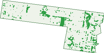
Green: 10 m cells where trees dominate, satellite 2021. Blue: water. The line is the suburb boundary.
| Canopy share, 1 m canopy height map, 2020 | 9.0% |
|---|---|
| Land with trees, 10 m satellite map, 2021 | 8.0% |
Demographics
Unemployment 3.5% · Labour-force participation 75.6%
Population by age in Prahran
| 0-4 | 494 |
|---|---|
| 5-14 | 565 |
| 15-19 | 292 |
| 20-24 | 963 |
| 25-34 | 3,802 |
| 35-44 | 2,203 |
| 45-54 | 1,327 |
| 55-64 | 1,030 |
| 65-74 | 751 |
| 75-84 | 518 |
| 85+ | 252 |
Dwelling types in Prahran
| House | 1,136 |
|---|---|
| Townhouse | 1,344 |
| Apartment | 3,702 |
| Other | 27 |
Households by weekly income in Prahran
| <$650 | 769 |
|---|---|
| $650-1,499 | 1,213 |
| $1,500-2,999 | 1,973 |
| $3,000+ | 1,983 |
Top ancestries in Prahran
| English | 4,177 |
|---|---|
| Australian | 2,929 |
| Other | 1,768 |
| Irish | 1,664 |
| Scottish | 1,369 |
| Greek | 828 |
Housing tenure in Prahran
| Owned | 1,224 |
|---|---|
| Mortgage | 1,486 |
| Rented | 3,370 |
| Other | 83 |
Cars per household in Prahran
| 0 | 1,401 |
|---|---|
| 1 | 3,299 |
| 2 | 1,205 |
| 3 | 181 |
| 4+ | 67 |
Commute to work in Prahran
| Car | 2,047 |
|---|---|
| Train | 270 |
| Bus | 16 |
| Tram/ferry | 317 |
| Walked | 528 |
| Bicycle | 134 |
| Home | 3,697 |
Top countries of birth in Prahran
| England | 559 |
|---|---|
| New Zealand | 389 |
| Greece | 327 |
| China | 181 |
| India | 175 |
| Ireland | 143 |
Languages used at home in Prahran
| Greek | 604 |
|---|---|
| Mandarin | 232 |
| Spanish | 183 |
| Italian | 105 |
| French | 100 |
| Cantonese | 93 |
Birds & Wildlife Nearby
415,798 bird observations recorded near Prahran — most often seen:
- Common Myna (25,898)
- Rainbow Lorikeet (23,627)
- Silver Gull (22,346)
- Magpie-lark (21,525)
- Little Raven (20,747)
- Noisy Miner (20,546)
- Rock Dove (19,990)
- Red Wattlebird (17,431)
- Australian Magpie (17,265)
- Pacific Black Duck (16,983)
- Dusky Moorhen (14,682)
- Spotted Turtle-dove (14,427)
- Eurasian Coot (13,418)
Show all 30 birds recorded near Prahran
- Little Pied Cormorant (13,362)
- Eurasian Blackbird (13,201)
- Welcome Swallow (13,129)
- Australian Wood Duck (11,871)
- Australasian Purple Swamphen (11,602)
- Common Starling (10,803)
- Chestnut Teal (10,509)
- Black Swan (10,489)
- Pied Currawong (9,812)
- Little Black Cormorant (9,377)
- Little Wattlebird (9,050)
- Sulphur-crested Cockatoo (8,405)
- House Sparrow (7,908)
- Grey Butcherbird (7,640)
- Willie Wagtail (6,843)
- Brown Thornbill (6,791)
- Crested Pigeon (6,121)
Sightings reported by observers, not a survey, so the counts show what people record rather than what lives here. Source: Atlas of Living Australia.
Nearby Suburbs
The closest suburbs to Prahran:
- Windsor (0.6 km)
- South Yarra (1.4 km)
- St Kilda East (1.6 km)
- Toorak (1.7 km)
- St Kilda (2 km)
- Armadale (2 km)
- Balaclava (2.1 km)
- St Kilda West (2.5 km)
Embed this suburb
Add this free Prahran stat card to your own site — just copy the code:
Preview:
Cite this page
Quoting these figures? Copy the credit line:
Keep an eye on Prahran
One email when this data meaningfully changes — new census figures, prices, rankings. No spam, unsubscribe anytime.
Streets
- Abeckett Street (61)
- Aberdeen Road (88)
- Airlie Avenue (88)
- Alfred Street (135)
- Anchor Place (42)
- Arkle Street (35)
- Athol Street (38)
- Bangs Street (598)
- Banole Avenue (52)
- Bayview Street (74)
- Bella Street (9)
- Bendigo Street (131)
- Bidey Street (7)
- Bowen Street (36)
- Brenchley Place (1)
- Burns Street (4)
- Carlton Street (48)
- Cato Street (9)
- Cecil Place (68)
- Chapel Street (353)
- Charles Street (120)
- Chatham Street (86)
- Chatsworth Road (135)
- Cheater Lane (1)
- Chomley Street (334)
- Clarke Street (124)
- Clifton Street (391)
- Closeburn Avenue (73)
- Commercial Road (228)
- Confectionery Lane (1)
- Continental Way (14)
- Craven Street (21)
- Dandenong Road (263)
- Dixon Street (10)
- Donald Street (153)
- Doon Street (11)
- Errol Street (27)
- Essex Street (228)
- Florence Street (23)
- Francis Street (20)
- Glass Place (2)
- Gooch Street (31)
- Grandview Grove (250)
- Grattan Street (447)
- Greville Street (441)
- Harvey Street (33)
- High Street (923)
- Highbury Grove (86)
- Hillingdon Place (93)
- Hinton Lane (8)
- Hurry Place (5)
- Irene Place (12)
- Irving Avenue (202)
- Ivy Street (37)
- Izett Street (105)
- Jessamine Avenue (56)
- Karbarook Avenue (36)
- Kelvin Court (6)
- Kelvin Grove (82)
- Kenleigh Grove (11)
- Kent Lane (8)
- King Street (430)
- Lalbert Crescent (54)
- Larnook Street (74)
- Leila Street (35)
- Lewisham Road N (46)
- Lexton Grove (60)
- Linden Court (10)
- Little Chapel Street (16)
- Lorne Road (44)
- Lumley Court (32)
- Mackay Street (48)
- Macquarie Street (133)
- Malvern Road (381)
- Maples Lane (9)
- Mcmicken Lane (2)
- Michie Mews (1)
- Miller Street (56)
- Molesworth Street (18)
- Moss Street (22)
- Mount Street (127)
- Murray Street (155)
- Nottingham Street (41)
- Orrong Road (6)
- Packington Place (22)
- Packington Street (31)
- Park Road (10)
- Percy Place (52)
- Percy Street (51)
- Perth Street (132)
- Pickford Street (16)
- Porter Street (645)
- Pridham Street (79)
- Princes Close (19)
- Princes Street (13)
- Punt Road (88)
- Rae Court (45)
- Regent Street (68)
- Robinson Street (76)
- Rudduck Close (3)
- Russell Street (19)
- Spring Street (91)
- St Edmonds Road (133)
- St Malo Street (7)
- St Matthews Way (3)
- Stawell Street (12)
- Summers Street (19)
- Sydney Street (165)
- Taylor Close (1)
- Thomas Place (14)
- Trinian Street (68)
- Vail Street (28)
- Walker Street (5)
- Wattle Street (6)
- Westbourne Street (54)
- Williams Road (354)
- Willis Street (18)
- Woodfull Street (29)
- Wrights Terrace (65)
- Wynnstay Road (163)
- York Place (9)
- York Street (194)