Portsea VIC 3944
2,219 addresses · 95 streets
Flinders Electorate › Mornington Peninsula LGA › Portsea · 61 km from Melbourne
📦 Thinking of moving here? Read the Portsea moving guide

Living Here
Portsea is a suburb of Victoria, home to about 787 people, with a median age of 68. The typical household earns around $2,470 a week, with median rent near $577 a week. Most homes are houses. About 90% of households own their home and 7% rent. Most workers work from home. Common community backgrounds include English, Australian, Irish. On the ABS socio-economic scale it sits in decile 10 of 10 nationally — a relatively advantaged area. The median house sells for about $3,330,000.
Over time — Census 2001 → 2021
Dashed line: district figures for the Point Nepean statistical area (SA2), the smallest area the ABS published before 2011. Solid line: Portsea itself.
Getting Around & Local Services
1 supermarket
1 Catholic church
1 pharmacy
1 medical clinic
2 post offices
2 gyms & sports centres
1 bakery
1 butcher
2 hardware stores
Getting around. Ferry wharf: Sorrento - Queenscliff Ferry, 2.7 km south-east · Airport: Avalon Airport, 38.7 km north-west.
Sport & Recreation
3 facilities recorded in Portsea.
- Portsea Golf Course Golf
- Portsea Recreation Reserve (Percy Cerutty Oval) Cricket, Tennis (Outdoor)
- Portsea Surf Life Saving Club Surf Life Saving
Socio-economic Standing
Deciles from 1 (lowest) to 10 (highest), against all Australian suburbs. The overall figure weighs advantage and disadvantage together; economic resources counts income and housing, and education & jobs counts qualifications and occupation. They often differ. Source: ABS SEIFA 2021.
Median Sale Prices
Median of recorded sales in the period, not a valuation. Source: Victorian Property Sales Report, Land Use Victoria.
Tree cover
🌳 Tree canopy: 41.6% share of land under canopy · satellite map, 2020
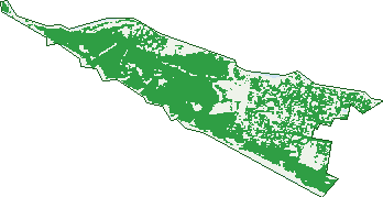
Green: 10 m cells where trees dominate, satellite 2021. Blue: water. The line is the suburb boundary.
| Canopy share, 1 m canopy height map, 2020 | 41.6% |
|---|---|
| Land with trees, 10 m satellite map, 2021 | 69.0% |
Demographics
Unemployment 2.3% · Labour-force participation 40.9%
Population by age in Portsea
| 0-4 | 9 |
|---|---|
| 5-14 | 20 |
| 15-19 | 11 |
| 20-24 | 12 |
| 25-34 | 24 |
| 35-44 | 24 |
| 45-54 | 63 |
| 55-64 | 157 |
| 65-74 | 235 |
| 75-84 | 191 |
| 85+ | 38 |
Dwelling types in Portsea
| House | 320 |
|---|---|
| Townhouse | 7 |
| Apartment | 0 |
| Other | 0 |
Households by weekly income in Portsea
| <$650 | 48 |
|---|---|
| $650-1,499 | 59 |
| $1,500-2,999 | 66 |
| $3,000+ | 136 |
Top ancestries in Portsea
| English | 398 |
|---|---|
| Australian | 210 |
| Irish | 143 |
| Scottish | 123 |
| Ancestry NS | 49 |
| German | 31 |
Housing tenure in Portsea
| Owned | 237 |
|---|---|
| Mortgage | 61 |
| Rented | 22 |
| Other | 10 |
Cars per household in Portsea
| 0 | 3 |
|---|---|
| 1 | 110 |
| 2 | 151 |
| 3 | 41 |
| 4+ | 24 |
Commute to work in Portsea
| Car | 101 |
|---|---|
| Train | 0 |
| Bus | 0 |
| Tram/ferry | 0 |
| Walked | 10 |
| Bicycle | 0 |
| Home | 153 |
Top countries of birth in Portsea
| England | 27 |
|---|---|
| New Zealand | 16 |
| Croatia | 6 |
| Greece | 5 |
| United States | 5 |
| India | 4 |
Languages used at home in Portsea
| Italian | 7 |
|---|---|
| Greek | 3 |
| Macedonian | 3 |
Birds & Wildlife Nearby
12,110 bird observations recorded near Portsea — most often seen:
- Australasian Gannet (980)
- Silver Gull (925)
- Australian Magpie (595)
- Pacific Gull (586)
- Welcome Swallow (586)
- Red Wattlebird (571)
- Crested Tern (541)
- Spiny-cheeked Honeyeater (473)
- Eurasian Blackbird (452)
- Little Raven (400)
- Brown Thornbill (396)
- Pied Cormorant (391)
- Little Pied Cormorant (390)
Show all 30 birds recorded near Portsea
- Singing Honeyeater (381)
- White-browed Scrubwren (364)
- Hooded Plover (349)
- Grey Fantail (321)
- Silvereye (313)
- Spotted Turtle-dove (287)
- White-faced Heron (276)
- Grey Shrike-thrush (273)
- Common Starling (270)
- Superb Fairy-wren (268)
- Black-faced Cormorant (266)
- Eastern Rosella (254)
- Great Cormorant (250)
- Little Wattlebird (250)
- Masked Lapwing (248)
- Willie Wagtail (228)
- Crimson Rosella (226)
Sightings reported by observers, not a survey, so the counts show what people record rather than what lives here. Source: Atlas of Living Australia.
Nearby Suburbs
The closest suburbs to Portsea:
- Sorrento (3.1 km)
- Blairgowrie (6.8 km)
- Queenscliff (8.7 km)
- Swan Island (9.2 km)
- Rye (10.1 km)
- Point Lonsdale (10.8 km)
- Tootgarook (12.9 km)
- Swan Bay (12.9 km)
Embed this suburb
Add this free Portsea stat card to your own site — just copy the code:
Preview:
Cite this page
Quoting these figures? Copy the credit line:
Keep an eye on Portsea
One email when this data meaningfully changes — new census figures, prices, rankings. No spam, unsubscribe anytime.
Streets
- Armytage Drive (27)
- Back Beach Road (147)
- Baillieu Court (5)
- Bass Road (21)
- Blair Court (23)
- Blair Road (65)
- Brook Crescent (3)
- Campbells Road (65)
- Carter Court (4)
- Charlton Court (14)
- Cheviot Road (14)
- Clovelly Court (6)
- Coker Crescent (2)
- Cove Avenue (17)
- Cypress Court (23)
- Delgany Avenue (27)
- Desbrowe Annear Way (3)
- Dickson Lane (4)
- Dicksons Lane (5)
- Docrell Lane (7)
- Driver Street (18)
- Duffy Street (29)
- Durcell Avenue (29)
- Elgar Grove (4)
- Elizabeth Road (70)
- Ernest Court (10)
- Farnsworth Avenue (21)
- Fitzjohns Court (9)
- Franklands Drive (12)
- Franklin Road (90)
- Frimmell Way (58)
- Gavan Street (15)
- Grosvenor Court (15)
- Hayden Court (14)
- Hemston Avenue (30)
- Hotham Road (40)
- Ibis Way (15)
- Ilyuka Court (6)
- Inveraray Court (5)
- Ivan Court (9)
- Janet Court (5)
- Judge Street (19)
- Kemp Road (1)
- Kindra Close (8)
- Lagoon Court (6)
- Latham Drive (34)
- Latrobe Avenue (1)
- Lawrance Grove (16)
- Levy Loop (1)
- Leyden Avenue (26)
- Limeburners Way (32)
- London Bridge Road (48)
- Macgregor Avenue (47)
- Martins Lane (44)
- Mccolls Way (3)
- Meredith Place (15)
- Merrylands Avenue (8)
- Nairana Court (19)
- Namarong Street (7)
- Nepean Place (43)
- Norfolk Drive (2)
- Nyland Court (4)
- Off Point King Road (3)
- Paringa Road (23)
- Pembroke Place (9)
- Pembroke Road (9)
- Point King Road (11)
- Point Nepean Road (365)
- Portsmouth Place (8)
- Ramler Mews (6)
- Relph Avenue (27)
- Robinson Place (27)
- Royal Avenue (17)
- Sahara Court (11)
- Sandy Court (8)
- Seabird Way (23)
- Shasta Way (3)
- Shelly Court (7)
- Somerset Avenue (12)
- Somerset Drive (14)
- Stonecutters Road (31)
- Tea Tree Rise (5)
- The Cutting (5)
- The Quarterdeck (27)
- Tranquility Court (10)
- Wanda Close (18)
- Wattle Grove (79)
- Weeroona Avenue (8)
- Weir Court (3)
- Welbeck Avenue (17)
- Wildcoast Road (31)
- Wimbledon Court (9)
- Wren Court (5)
- Wyuna Court (8)
- Yerlata Court (10)