Paynesville VIC 3880
3,693 addresses · 128 streets
Gippsland Electorate › East Gippsland LGA › Paynesville · 242 km from Melbourne
📦 Thinking of moving here? Read the Paynesville moving guide

Living Here
Paynesville is a suburb of Victoria, home to about 3,636 people, with a median age of 62. The typical household earns around $987 a week, with median rent near $310 a week. Most homes are houses. About 78% of households own their home and 22% rent. Most workers drive to work. Common community backgrounds include English, Australian, Scottish. On the ABS socio-economic scale it sits in decile 3 of 10 nationally — a more disadvantaged area. The median house sells for about $502,500.
Over time — Census 2001 → 2021
Dashed line: district figures for the Paynesville statistical area (SA2), the smallest area the ABS published before 2011. Solid line: Paynesville itself.
Getting Around & Local Services
1 supermarket
1 park
1 Catholic church
1 medical clinic
1 hospital
1 childcare centre
1 library
1 post office
1 service station
1 golf club
1 playground
1 bakery
2 hairdressers
Getting around. Ferry wharf: Raymond Island Ferry, 1.1 km south-east · Airport: Bairnsdale Airport, 13.5 km west.
Sport & Recreation
3 facilities recorded in Paynesville.
- A.J Freeman Reserve Australian Rules Football, Cricket, Netball, Tennis (Outdoor)
- Gippsland Lakes Yacht Club Sailing
- Paynesville Bowling Club Lawn Bowls
Socio-economic Standing
Deciles from 1 (lowest) to 10 (highest), against all Australian suburbs. The overall figure weighs advantage and disadvantage together; economic resources counts income and housing, and education & jobs counts qualifications and occupation. They often differ. Source: ABS SEIFA 2021.
Median Sale Prices
Median of recorded sales in the period, not a valuation. Source: Victorian Property Sales Report, Land Use Victoria.
Tree cover
🌳 Tree canopy: 7% share of land under canopy · satellite map, 2020
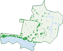
Green: 10 m cells where trees dominate, satellite 2021. Blue: water. The line is the suburb boundary.
| Canopy share, 1 m canopy height map, 2020 | 7.0% |
|---|---|
| Land with trees, 10 m satellite map, 2021 | 8.6% |
Demographics
Unemployment 5% · Labour-force participation 38.1%
Population by age in Paynesville
| 0-4 | 96 |
|---|---|
| 5-14 | 266 |
| 15-19 | 111 |
| 20-24 | 95 |
| 25-34 | 219 |
| 35-44 | 218 |
| 45-54 | 352 |
| 55-64 | 609 |
| 65-74 | 892 |
| 75-84 | 578 |
| 85+ | 192 |
Dwelling types in Paynesville
| House | 1,434 |
|---|---|
| Townhouse | 189 |
| Apartment | 20 |
| Other | 31 |
Households by weekly income in Paynesville
| <$650 | 414 |
|---|---|
| $650-1,499 | 652 |
| $1,500-2,999 | 343 |
| $3,000+ | 137 |
Top ancestries in Paynesville
| English | 1,835 |
|---|---|
| Australian | 1,344 |
| Scottish | 533 |
| Irish | 455 |
| German | 179 |
| Other | 144 |
Housing tenure in Paynesville
| Owned | 949 |
|---|---|
| Mortgage | 324 |
| Rented | 353 |
| Other | 10 |
Cars per household in Paynesville
| 0 | 56 |
|---|---|
| 1 | 658 |
| 2 | 653 |
| 3 | 188 |
| 4+ | 79 |
Commute to work in Paynesville
| Car | 812 |
|---|---|
| Train | 0 |
| Bus | 0 |
| Tram/ferry | 0 |
| Walked | 24 |
| Bicycle | 3 |
| Home | 162 |
Top countries of birth in Paynesville
| England | 255 |
|---|---|
| New Zealand | 58 |
| Netherlands | 41 |
| Scotland | 38 |
| Germany | 29 |
| India | 19 |
Languages used at home in Paynesville
| German | 14 |
|---|---|
| Afrikaans | 9 |
| Mandarin | 9 |
| Malayalam | 9 |
| Filipino | 6 |
| Vietnamese | 6 |
Birds & Wildlife Nearby
36,719 bird observations recorded near Paynesville — most often seen:
- Black Swan (2,086)
- Little Pied Cormorant (1,738)
- Australian Pelican (1,736)
- Little Black Cormorant (1,498)
- Chestnut Teal (1,472)
- Eurasian Coot (1,380)
- Australian Magpie (1,359)
- Silver Gull (1,342)
- Rainbow Lorikeet (1,298)
- Great Cormorant (1,218)
- Red Wattlebird (1,209)
- Welcome Swallow (1,209)
- Common Bronzewing (1,204)
Show all 30 birds recorded near Paynesville
- Common Starling (1,203)
- White-faced Heron (1,190)
- Crimson Rosella (1,146)
- Magpie-lark (1,144)
- Crested Tern (1,127)
- Masked Lapwing (1,115)
- Superb Fairy-wren (1,113)
- Noisy Miner (1,088)
- Sulphur-crested Cockatoo (1,057)
- Eastern Rosella (1,043)
- Laughing Kookaburra (1,028)
- Grey Fantail (1,003)
- Galah (1,002)
- Grey Butcherbird (966)
- Australian White Ibis (947)
- Australian Wood Duck (912)
- Little Wattlebird (886)
Sightings reported by observers, not a survey, so the counts show what people record rather than what lives here. Source: Atlas of Living Australia.
Nearby Suburbs
The closest suburbs to Paynesville:
- Raymond Island (1.6 km)
- Newlands Arm (2.4 km)
- Eagle Point (3.4 km)
- Banksia Peninsula (6 km)
- Broadlands (7.8 km)
- Forge Creek (8.4 km)
- Ocean Grange (9.7 km)
- East Bairnsdale (10.9 km)
Embed this suburb
Add this free Paynesville stat card to your own site — just copy the code:
Preview:
Cite this page
Quoting these figures? Copy the credit line:
Keep an eye on Paynesville
One email when this data meaningfully changes — new census figures, prices, rankings. No spam, unsubscribe anytime.
Streets
- Acacia Court (16)
- Admirals Quay (20)
- Ah Yee Place (10)
- Alice Court (5)
- Apollo Close (6)
- Aquarius Way (28)
- Araluen Court (6)
- Ashley Street (57)
- Backwater Court (17)
- Basstian Court (4)
- Bedggood Grove (45)
- Beechey Place (3)
- Bindi Court (6)
- Bishop View (15)
- Blake Avenue (20)
- Bridge Place (1)
- Bungaree Avenue (6)
- Burden Place (24)
- Caddie Court (6)
- Callistemon Court (12)
- Camellia Close (4)
- Canal Road (79)
- Charlotte Fenwick Boulevard (14)
- Coast Avenue (34)
- Cumming Street (61)
- Devon Road (4)
- Digney Street (10)
- Driftwood Close (26)
- Eagle Bay Terrace (44)
- Eaton Place (10)
- Emily May Parade (4)
- Erickson Lane (9)
- Esplanade (80)
- Firefly Lane (4)
- Fleischer Street (5)
- Fort King Place (17)
- Fort King Road (71)
- Fullarton Drive (58)
- George Street (1)
- Gilsenan Street (94)
- Government Road (13)
- Grandview Road (26)
- Hakea Court (14)
- Hancock Court (10)
- Harbour Court (9)
- Haylock Drive (33)
- Hayman Place (6)
- Headland Terrace (20)
- Heaths View (18)
- Idalia Lane (6)
- Ilfracombe Way (37)
- Infinity Court (8)
- Jacaranda Drive (10)
- Jim Way (18)
- Kellina Court (15)
- King Street (189)
- Kings Road (29)
- Lady Harriett Lane (22)
- Lady Loch Lane (12)
- Lake Shore Drive (1)
- Langford Parade (175)
- Lara Close (20)
- Lewis Place (19)
- Lindemann Retreat (6)
- Lotus Place (10)
- Magnetic Retreat (30)
- Magnolia Way (13)
- Main Road (196)
- Maitland Lane (5)
- Manoora Avenue (4)
- Mara Close (8)
- Marina Drive (19)
- Mariners Place (8)
- May Park Drive (46)
- Mcmillan Grove (44)
- Milton Avenue (19)
- Mitchell Street (52)
- Napier Lane (32)
- Nautilus Close (14)
- Newlands Drive (235)
- Newton Close (31)
- North Quay Place (12)
- Oakley Crescent (9)
- Palm Avenue (8)
- Parkwood Close (9)
- Paynesville Road (46)
- Pma Marina (4)
- Pretty Jane Lane (15)
- Queen Street (30)
- Queenscliffe Street (19)
- Raymond Street (2)
- Rex Street (25)
- Reynolds Street (43)
- Riviera Close (27)
- Rosedale Way (47)
- Schoolyard Court (7)
- Schooner Terrace (39)
- Sheerwater Terrace (23)
- Simpson Street (10)
- Slip Road (124)
- Smallman Court (18)
- Sunset Boulevard (27)
- Sunset Drive (4)
- Tambo Avenue (11)
- Tanjil Avenue (15)
- The Beacons (13)
- The Crescent (18)
- The Grange (27)
- The Inlet (23)
- The Moorings (11)
- The Point (23)
- Toonalook Parade (62)
- Toonalook Waters (1)
- Twomey Place (9)
- Vaughan Street (65)
- Victoria Street (104)
- View Street (13)
- Wanda Close (16)
- Waratah Avenue (25)
- Waterlily Way (5)
- Waterloo Court (17)
- Waverley Court (10)
- Wellington Street (137)
- William Street (32)
- Windermere Terrace (32)
- Windjammer Court (29)
- Wisteria Place (13)
- Woodland Court (16)