North Wonthaggi VIC 3995
2,199 addresses · 78 streets
Monash Electorate › Bass Coast LGA › North Wonthaggi · 103 km from Melbourne
📦 Thinking of moving here? Read the North Wonthaggi moving guide

Living Here
North Wonthaggi is a suburb of Victoria, home to about 3,475 people, with a median age of 42. The typical household earns around $1,162 a week, with median rent near $300 a week. Most homes are houses. About 78% of households own their home and 20% rent. Most workers drive to work. Common community backgrounds include English, Australian, Irish. On the ABS socio-economic scale it sits in decile 2 of 10 nationally — a more disadvantaged area. The median house sells for about $552,000.
Over time — Census 2001 → 2021
Dashed line: district figures for the Wonthaggi - Inverloch statistical area (SA2), the smallest area the ABS published before 2011. Solid line: North Wonthaggi itself.
Getting Around & Local Services
4 supermarkets
2 pharmacies
5 doctors & medical clinics
1 dentist
1 physiotherapist
2 optometrists
2 hospitals
1 vet
2 childcare & kindergartens
1 library
1 post office
5 service stations
2 gyms & sports centres
1 golf club
1 playground
2 bakeries
1 butcher
2 hardware stores
2 hairdressers
1 beauty salon
Socio-economic Standing
Deciles from 1 (lowest) to 10 (highest), against all Australian suburbs. The overall figure weighs advantage and disadvantage together; economic resources counts income and housing, and education & jobs counts qualifications and occupation. They often differ. Source: ABS SEIFA 2021.
Median Sale Prices
Median of recorded sales in the period, not a valuation. Source: Victorian Property Sales Report, Land Use Victoria.
Tree cover
🌳 Tree canopy: 3.8% share of land under canopy · satellite map, 2020
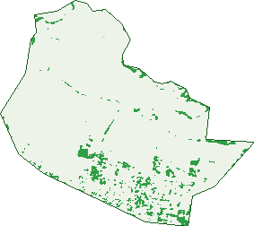
Green: 10 m cells where trees dominate, satellite 2021. Blue: water. The line is the suburb boundary.
| Canopy share, 1 m canopy height map, 2020 | 3.8% |
|---|---|
| Land with trees, 10 m satellite map, 2021 | 4.9% |
Demographics
Unemployment 4.8% · Labour-force participation 53.5%
Population by age in North Wonthaggi
| 0-4 | 185 |
|---|---|
| 5-14 | 427 |
| 15-19 | 211 |
| 20-24 | 201 |
| 25-34 | 418 |
| 35-44 | 372 |
| 45-54 | 391 |
| 55-64 | 437 |
| 65-74 | 479 |
| 75-84 | 279 |
| 85+ | 68 |
Dwelling types in North Wonthaggi
| House | 1,340 |
|---|---|
| Townhouse | 10 |
| Apartment | 4 |
| Other | 0 |
Households by weekly income in North Wonthaggi
| <$650 | 301 |
|---|---|
| $650-1,499 | 475 |
| $1,500-2,999 | 381 |
| $3,000+ | 106 |
Top ancestries in North Wonthaggi
| English | 1,573 |
|---|---|
| Australian | 1,345 |
| Irish | 390 |
| Scottish | 374 |
| Italian | 239 |
| Other | 214 |
Housing tenure in North Wonthaggi
| Owned | 612 |
|---|---|
| Mortgage | 440 |
| Rented | 275 |
| Other | 15 |
Cars per household in North Wonthaggi
| 0 | 57 |
|---|---|
| 1 | 470 |
| 2 | 538 |
| 3 | 176 |
| 4+ | 103 |
Commute to work in North Wonthaggi
| Car | 1,080 |
|---|---|
| Train | 0 |
| Bus | 4 |
| Tram/ferry | 0 |
| Walked | 27 |
| Bicycle | 16 |
| Home | 110 |
Top countries of birth in North Wonthaggi
| England | 143 |
|---|---|
| New Zealand | 51 |
| India | 33 |
| Netherlands | 25 |
| Thailand | 24 |
| Italy | 23 |
Languages used at home in North Wonthaggi
| Malayalam | 34 |
|---|---|
| Italian | 16 |
| Thai | 15 |
| Mandarin | 12 |
| Nepali | 9 |
| Greek | 7 |
Birds & Wildlife Nearby
26,523 bird observations recorded near North Wonthaggi — most often seen:
- Common Starling (1,500)
- Australian Magpie (1,311)
- Australasian Purple Swamphen (1,250)
- Pacific Black Duck (1,227)
- Eurasian Blackbird (1,221)
- Superb Fairy-wren (1,188)
- Chestnut Teal (1,123)
- Little Raven (1,051)
- Grey Fantail (1,000)
- Welcome Swallow (971)
- Black Swan (967)
- Red Wattlebird (965)
- Eurasian Coot (944)
Show all 30 birds recorded near North Wonthaggi
- White-faced Heron (937)
- Common Myna (853)
- Australian White Ibis (846)
- European Goldfinch (832)
- Magpie-lark (774)
- Grey Shrike-thrush (743)
- Masked Lapwing (733)
- White-eared Honeyeater (711)
- Dusky Moorhen (645)
- New Holland Honeyeater (644)
- Yellow-faced Honeyeater (618)
- Straw-necked Ibis (610)
- White-naped Honeyeater (610)
- Brown Thornbill (598)
- Spotted Turtle-dove (570)
- Eastern Yellow Robin (541)
- Southern Victoria Australian Magpie (540)
Sightings reported by observers, not a survey, so the counts show what people record rather than what lives here. Source: Atlas of Living Australia.
Nearby Suburbs
The closest suburbs to North Wonthaggi:
- Wonthaggi (1.9 km)
- South Dudley (1.9 km)
- St Clair (4.4 km)
- West Creek (4.7 km)
- Dalyston (5.5 km)
- Archies Creek (5.5 km)
- Harmers Haven (7.3 km)
- Lance Creek (8.3 km)
Embed this suburb
Add this free North Wonthaggi stat card to your own site — just copy the code:
Preview:
Cite this page
Quoting these figures? Copy the credit line:
Keep an eye on North Wonthaggi
One email when this data meaningfully changes — new census figures, prices, rankings. No spam, unsubscribe anytime.
Streets
- Apple Berry Rise (20)
- Ash Chase (3)
- Ash Grange (25)
- Benetti Road (3)
- Bond Street (3)
- Bryden Drive (16)
- Burgan Avenue (29)
- Cambridge Way (19)
- Canary Way (15)
- Carbine Street (11)
- Cavil Drive (45)
- Centennial Drive (12)
- Cobber Way (9)
- Colliery Avenue (48)
- Deakin Street (7)
- Delmarni Court (17)
- Domain Drive (10)
- Donald Street (33)
- Edinburgh Drive (3)
- Fault Crescent (26)
- Fuller Road (71)
- George Street (1)
- Gordon Street (95)
- Griffiths Street (80)
- Hampshire Place (2)
- Haywood Place (10)
- Henry Street E (33)
- Henry Street W (31)
- Heslop Road (4)
- Hicksborough Way (4)
- Hop Street (2)
- Ivor Street (73)
- James Street (6)
- Jersey Road (17)
- Kingston Road (50)
- Kirrak Street (74)
- Korumburra Road (10)
- Korumburra-wonthaggi Road (3)
- Lamp Road (18)
- Langley Way (12)
- Lewis Avenue (5)
- Loch-wonthaggi Road (4)
- Longstaff Street (15)
- Lyndhurst Street (58)
- Mary Street (24)
- Mcgibbonys Road (1)
- Mcmahon Way (16)
- Minatori Close (7)
- Morey Street (24)
- Nelson Street (99)
- North View Drive (30)
- Oates Road (17)
- Obrien Circuit (54)
- Ogarey Street (1)
- Ormsby Grove (2)
- Oxford Way (78)
- Parkes Street (35)
- Pear Tree Close (22)
- Powlett Road (3)
- Regency Drive (23)
- Rib Court (5)
- Ryan Way (8)
- Seam Street (10)
- Splint Way (8)
- St Andrews Place (5)
- St Elena Court (15)
- Storey Street (53)
- Sussex Court (23)
- Tibballs Place (2)
- Token Street (19)
- Toorak Street (50)
- Turner Street (111)
- Tussock Way (22)
- Vicars Avenue (29)
- Wallace Street (58)
- Wentworth Road (107)
- White Road (195)
- Willow Court (11)