Nhill VIC 3418
1,617 addresses · 168 streets
Mallee Electorate › Hindmarsh LGA › Nhill · 338 km from Melbourne
📦 Thinking of moving here? Read the Nhill moving guide

Living Here
Nhill is a suburb of Victoria, home to about 2,401 people, with a median age of 47. The typical household earns around $1,296 a week, with median rent near $200 a week. Most homes are houses. About 75% of households own their home and 23% rent. Most workers drive to work. Common community backgrounds include English, Australian, German. On the ABS socio-economic scale it sits in decile 2 of 10 nationally — a more disadvantaged area. The median house sells for about $265,000.
Over time — Census 2001 → 2021
Dashed line: district figures for the Nhill Region statistical area (SA2), the smallest area the ABS published before 2011. Solid line: Nhill itself.
Getting Around & Local Services
3 cafés & restaurants
1 supermarket
1 pharmacy
1 dentist
1 hospital
1 library
1 post office
4 service stations
2 gyms & sports centres
1 golf club
1 playground
2 bakeries
2 hardware stores
2 beauty salons
3 mechanics
2 places to stay
Getting around. Train station: Nhill, 900 m east.
Sport & Recreation
7 facilities recorded in Nhill.
- Davis Park Australian Rules Football, Cricket, Hockey, Netball, Soccer
- Lowan Sports Centre Badminton, Basketball, Fitness / Gymnasium Workouts, Squash / Racquetball
- Nhill Bowls Club Lawn Bowls
- Nhill Golf Course Golf
- Nhill Showgrounds Equestrian
- Nhill Swimming Pool Swimming
- Nhill Tennis Club Tennis (Outdoor)
Socio-economic Standing
Deciles from 1 (lowest) to 10 (highest), against all Australian suburbs. The overall figure weighs advantage and disadvantage together; economic resources counts income and housing, and education & jobs counts qualifications and occupation. They often differ. Source: ABS SEIFA 2021.
Median Sale Prices
Median of recorded sales in the period, not a valuation. Source: Victorian Property Sales Report, Land Use Victoria.
Tree cover
🌳 Tree canopy: 1.7% share of land under canopy · satellite map, 2020
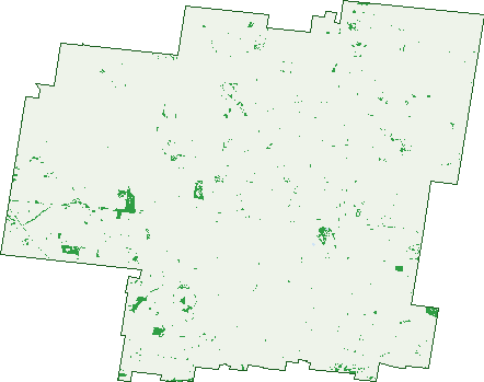
Green: 10 m cells where trees dominate, satellite 2021. Blue: water. The line is the suburb boundary.
| Canopy share, 1 m canopy height map, 2020 | 1.7% |
|---|---|
| Land with trees, 10 m satellite map, 2021 | 2.0% |
Demographics
Unemployment 2.4% · Labour-force participation 56.2%
Population by age in Nhill
| 0-4 | 122 |
|---|---|
| 5-14 | 245 |
| 15-19 | 128 |
| 20-24 | 115 |
| 25-34 | 324 |
| 35-44 | 214 |
| 45-54 | 282 |
| 55-64 | 325 |
| 65-74 | 263 |
| 75-84 | 248 |
| 85+ | 133 |
Dwelling types in Nhill
| House | 888 |
|---|---|
| Townhouse | 58 |
| Apartment | 8 |
| Other | 0 |
Households by weekly income in Nhill
| <$650 | 200 |
|---|---|
| $650-1,499 | 303 |
| $1,500-2,999 | 285 |
| $3,000+ | 95 |
Top ancestries in Nhill
| English | 904 |
|---|---|
| Australian | 872 |
| German | 313 |
| Other | 297 |
| Scottish | 242 |
| Ancestry NS | 192 |
Housing tenure in Nhill
| Owned | 447 |
|---|---|
| Mortgage | 250 |
| Rented | 217 |
| Other | 20 |
Cars per household in Nhill
| 0 | 56 |
|---|---|
| 1 | 302 |
| 2 | 320 |
| 3 | 140 |
| 4+ | 114 |
Commute to work in Nhill
| Car | 741 |
|---|---|
| Train | 0 |
| Bus | 5 |
| Tram/ferry | 0 |
| Walked | 113 |
| Bicycle | 9 |
| Home | 108 |
Top countries of birth in Nhill
| Myanmar | 107 |
|---|---|
| Thailand | 77 |
| India | 34 |
| England | 28 |
| Philippines | 27 |
| New Zealand | 19 |
Languages used at home in Nhill
| Tagalog | 13 |
|---|---|
| Samoan | 9 |
| Vietnamese | 9 |
| Filipino | 8 |
| Malayalam | 7 |
| Urdu | 6 |
Birds & Wildlife Nearby
4,295 bird observations recorded near Nhill — most often seen:
- Pacific Black Duck (247)
- Australian Magpie (242)
- Noisy Miner (231)
- Grey Teal (219)
- Eurasian Coot (214)
- Dusky Moorhen (191)
- Magpie-lark (190)
- Common Starling (188)
- Australasian Grebe (185)
- Long-billed Corella (183)
- Eastern Rosella (179)
- Welcome Swallow (157)
- Galah (156)
Show all 30 birds recorded near Nhill
- White-plumed Honeyeater (151)
- Willie Wagtail (138)
- Red Wattlebird (134)
- House Sparrow (132)
- Little Pied Cormorant (127)
- Red-rumped Parrot (116)
- Crested Pigeon (112)
- White-faced Heron (103)
- Eurasian Blackbird (97)
- Little Corella (85)
- Laughing Kookaburra (83)
- Masked Lapwing (82)
- Rock Dove (74)
- White-winged Chough (73)
- Hoary-headed Grebe (70)
- Australian Wood Duck (68)
- Black-tailed Native-hen (68)
Sightings reported by observers, not a survey, so the counts show what people record rather than what lives here. Source: Atlas of Living Australia.
Nearby Suburbs
The closest suburbs to Nhill:
- Kiata (13.2 km)
- Little Desert (15.3 km)
- Glenlee (18.9 km)
- Lawloit (19.6 km)
- Gerang Gerung (21.8 km)
- Lorquon (22.8 km)
- Netherby (25.7 km)
- Miram (26 km)
Embed this suburb
Add this free Nhill stat card to your own site — just copy the code:
Preview:
Cite this page
Quoting these figures? Copy the credit line:
Keep an eye on Nhill
One email when this data meaningfully changes — new census figures, prices, rankings. No spam, unsubscribe anytime.
Streets
- A Bones Road (3)
- A Rintoules Road (2)
- Aerodrome Road (2)
- Albert Street (3)
- Arnold Street (4)
- B Barbers Road (3)
- B Farmers Road (1)
- Baker Street (11)
- Belcher Street (26)
- Bell Street (6)
- Boyeo-tarranginnie Road (1)
- Breda Street (6)
- Brougham Street (30)
- Bywaters Road (1)
- C Werners Road (7)
- Campbell Street (20)
- Church Street (39)
- Clarence Street (56)
- Clark Street (17)
- Coles Street (7)
- Cutline Road (3)
- D Bells Road (1)
- D Manns Road (2)
- Dahlenburg Drive (1)
- Davis Avenue (25)
- Deckerts Road (1)
- Diapur-lawloit Road (1)
- Diapur-miram Road (7)
- Diapur-nhill Road (2)
- Diapur-yanac Road (2)
- Dimboola Road (39)
- Drapers Road (1)
- Dry Cleaners Lane (1)
- Dufty Road (1)
- Eastick Road (1)
- Easticks Road (1)
- Elizabeth Street (7)
- Ervins Road (1)
- F Jarreds Road (2)
- Farmers Road (1)
- Farmers Street (12)
- Fraser Street (14)
- Fritsch Court (5)
- Fritsh Court (5)
- G Clarks Road (1)
- G Dahlenburg Road (1)
- G Deckerts Road (2)
- G Schultzs Road (1)
- George Street (36)
- Glenferness Street (15)
- Gneils Road (1)
- Goldsworthy Street (8)
- Gunn Street (10)
- H Binns Road (2)
- Halls Road (5)
- Hamlyns Road (2)
- Hardings Road (1)
- Hensleys Road (1)
- Hindmarsh Court (11)
- I Kennedys Road (2)
- J Bones Road (1)
- J Donnell Road (1)
- J Teakles Road (1)
- James Street (7)
- Janetzkis Road (1)
- Johnston Street (3)
- K Binns Road (1)
- K Borgelts Road (1)
- K Clarks Road (2)
- K Harris Road (2)
- K Schultz Road (1)
- Keams Road (1)
- Kellers Road (1)
- Kennedys Road (1)
- King Street (7)
- Kinimakatka Road (6)
- Koop Road (2)
- Krauses Road (1)
- L Bones Road (2)
- L Borgelts Road (1)
- L Creek Road (1)
- Laceys Road (1)
- Langford Street (14)
- Lavertys Road (1)
- Leahy Street (79)
- Lipshut Road (1)
- Lipshuts Road (1)
- Loch Street (16)
- Lorquon Road (2)
- Lorquon-woorak West Road (4)
- Lowes Road (1)
- Luberta Street (9)
- Lynchs Road (1)
- Mackay Street (17)
- Macpherson Street (157)
- Madden Street (16)
- Mallee Dam Road (1)
- Mays Road (3)
- Mcdonald Street (15)
- Mcdonalds Road (4)
- Mckenzie Avenue (2)
- Middleton Avenue (5)
- Miller Lane (1)
- Miram East Road (1)
- Mt Elgin Road (3)
- Mullers Road (1)
- Nairn Street (12)
- Nelson Street (177)
- Netherby South Road (1)
- Nhill-diapur Road (6)
- Nhill-harrow Road (10)
- Nhill-jeparit Road (9)
- Nhill-netherby Road (11)
- Nhill-yanac Road (11)
- Oreillys Road (2)
- P Colbert Road (1)
- P Colberts Road (1)
- P Warners Road (2)
- Park Street (35)
- Peakes Three Chain Road (6)
- Pikers Road (3)
- Pilgrims Road (1)
- Pine Street (17)
- Propodollah Extension Road (5)
- Propodollah Road (14)
- Propodollah-netherby Road (2)
- Queen Street (44)
- R Kellers Road (1)
- R Lowes Road (1)
- Ramsay Street (16)
- Reserve Road (2)
- Rethus Drive (5)
- Ridgwell Road (2)
- Ridgwells Road (2)
- Rintoule Street (12)
- Rockley Street (43)
- Rogers Road (3)
- Rupps Road (1)
- Russell Street (10)
- Sandsmere Road (2)
- Siemerings Road (1)
- Station Street (4)
- Stephans Road (1)
- Teakles Road (1)
- Thomas Street (8)
- Townsend Street (67)
- Turner Street (4)
- Uthmeyers Road (1)
- Victoria Street (82)
- W Cooks Road (1)
- Ward Street (9)
- Weirs Road (1)
- Werner Road (2)
- Werners Road (2)
- Westendorfs Road (1)
- Western Highway (12)
- Whitehead Avenue (6)
- William Street (13)
- Winiam East Road (11)
- Winiam Hall Road (2)
- Winiam Road (1)
- Woodward Street (17)
- Woorak Cemetery Road (1)
- Woorak Church Road (2)
- Woorak West-ni Ni Road (1)
- Woorak-ni Ni-lorquon Road (8)
- Yanac South Road (1)
- Young Street (7)