Nagambie VIC 3608
2,574 addresses · 90 streets
Nicholls Electorate › Strathbogie LGA › Nagambie · 115 km from Melbourne
📦 Thinking of moving here? Read the Nagambie moving guide

Living Here
Nagambie is a suburb of Victoria, home to about 2,254 people, with a median age of 51. The typical household earns around $1,144 a week, with median rent near $295 a week. Most homes are houses. About 74% of households own their home and 24% rent. Most workers drive to work. Common community backgrounds include Australian, English, Irish. On the ABS socio-economic scale it sits in decile 3 of 10 nationally — a more disadvantaged area. The median house sells for about $630,000.
Over time — Census 2001 → 2021
Dashed line: district figures for the Nagambie statistical area (SA2), the smallest area the ABS published before 2011. Solid line: Nagambie itself.
Getting Around & Local Services
1 supermarket
1 park
2 doctors & medical clinics
1 dentist
1 childcare centre
1 library
1 post office
1 gym
1 golf club
1 playground
1 bakery
1 hairdresser
Getting around. Airport: Shepparton Airport, 45.2 km north-east.
Sport & Recreation
8 facilities recorded in Nagambie.
- Nagambie Bowling Club Lawn Bowls
- Nagambie Croquet Club Croquet
- Nagambie Lakes Sailing Club Sailing
- Nagambie Recreation Reserve Australian Rules Football, Cricket, Netball
- Nagambie Regatta Centre Rowing
- Nagambie Rowing Club Rowing
- Nagambie Swimming Pool Swimming
- Nagambie Tennis Club Tennis (Outdoor)
Socio-economic Standing
Deciles from 1 (lowest) to 10 (highest), against all Australian suburbs. The overall figure weighs advantage and disadvantage together; economic resources counts income and housing, and education & jobs counts qualifications and occupation. They often differ. Source: ABS SEIFA 2021.
Median Sale Prices
Median of recorded sales in the period, not a valuation. Source: Victorian Property Sales Report, Land Use Victoria.
Tree cover
🌳 Tree canopy: 9.2% share of land under canopy · satellite map, 2020
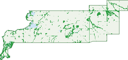
Green: 10 m cells where trees dominate, satellite 2021. Blue: water. The line is the suburb boundary.
| Canopy share, 1 m canopy height map, 2020 | 9.2% |
|---|---|
| Land with trees, 10 m satellite map, 2021 | 12.1% |
Demographics
Unemployment 3.8% · Labour-force participation 51.6%
Population by age in Nagambie
| 0-4 | 134 |
|---|---|
| 5-14 | 213 |
| 15-19 | 95 |
| 20-24 | 85 |
| 25-34 | 218 |
| 35-44 | 244 |
| 45-54 | 218 |
| 55-64 | 355 |
| 65-74 | 393 |
| 75-84 | 207 |
| 85+ | 92 |
Dwelling types in Nagambie
| House | 831 |
|---|---|
| Townhouse | 69 |
| Apartment | 0 |
| Other | 39 |
Households by weekly income in Nagambie
| <$650 | 241 |
|---|---|
| $650-1,499 | 305 |
| $1,500-2,999 | 209 |
| $3,000+ | 122 |
Top ancestries in Nagambie
| Australian | 896 |
|---|---|
| English | 896 |
| Irish | 312 |
| Scottish | 253 |
| Ancestry NS | 216 |
| Other | 90 |
Housing tenure in Nagambie
| Owned | 444 |
|---|---|
| Mortgage | 245 |
| Rented | 222 |
| Other | 15 |
Cars per household in Nagambie
| 0 | 48 |
|---|---|
| 1 | 362 |
| 2 | 323 |
| 3 | 119 |
| 4+ | 73 |
Commute to work in Nagambie
| Car | 673 |
|---|---|
| Train | 3 |
| Bus | 0 |
| Tram/ferry | 0 |
| Walked | 46 |
| Bicycle | 0 |
| Home | 97 |
Top countries of birth in Nagambie
| England | 52 |
|---|---|
| New Zealand | 20 |
| Philippines | 17 |
| India | 13 |
| Germany | 11 |
| Poland | 10 |
Languages used at home in Nagambie
| Italian | 12 |
|---|---|
| Mandarin | 11 |
| Filipino | 11 |
| Polish | 10 |
| Urdu | 6 |
| Khmer | 6 |
Birds & Wildlife Nearby
6,936 bird observations recorded near Nagambie — most often seen:
- Pacific Black Duck (415)
- Australasian Purple Swamphen (373)
- Australian Magpie (362)
- Australian Wood Duck (325)
- Black Swan (302)
- Welcome Swallow (301)
- Australian White Ibis (281)
- White-plumed Honeyeater (279)
- Eurasian Coot (274)
- Willie Wagtail (271)
- Galah (242)
- House Sparrow (236)
- Sulphur-crested Cockatoo (232)
Show all 30 birds recorded near Nagambie
- Red Wattlebird (216)
- Little Raven (213)
- Eastern Rosella (209)
- Magpie-lark (208)
- Little Pied Cormorant (202)
- Dusky Moorhen (190)
- Red-rumped Parrot (188)
- Grey Teal (186)
- Crested Pigeon (168)
- Eurasian Blackbird (166)
- Little Corella (166)
- Straw-necked Ibis (165)
- Superb Fairy-wren (163)
- White-faced Heron (161)
- Long-billed Corella (156)
- Masked Lapwing (148)
- Australasian Grebe (138)
Sightings reported by observers, not a survey, so the counts show what people record rather than what lives here. Source: Atlas of Living Australia.
Nearby Suburbs
The closest suburbs to Nagambie:
- Kirwans Bridge (5.1 km)
- Tabilk (6 km)
- Goulburn Weir (7.7 km)
- Bailieston (8 km)
- Mitchellstown (9.6 km)
- Wirrate (12.1 km)
- Wahring (12.9 km)
- Whroo (13.6 km)
Embed this suburb
Add this free Nagambie stat card to your own site — just copy the code:
Preview:
Cite this page
Quoting these figures? Copy the credit line:
Keep an eye on Nagambie
One email when this data meaningfully changes — new census figures, prices, rankings. No spam, unsubscribe anytime.
Streets
- Akers Road (3)
- Amaroo Boulevard (20)
- Ballantynes Road (14)
- Barwon Street (55)
- Bathurst Lane (2)
- Blayney Lane (73)
- Boyd Street (23)
- Bryde Street (10)
- Callaghan Court (6)
- Camowen Crescent (15)
- Campaspe Court (8)
- Carmichael Court (11)
- Carrick Crescent (29)
- Cemetery Lane (14)
- Centenary Crescent (23)
- Chapman Lane (8)
- Church Street (27)
- Coes Road (1)
- Cottage Lane (3)
- Curramar Close (5)
- Curtis Court (20)
- Dargalong Road (2)
- Elloura Drive (10)
- Eureka Drive (21)
- Filson Street (44)
- Glass Street (4)
- Glencairn Lane (6)
- Goldanah Avenue (25)
- Goulburn Street (81)
- Goulburn Valley Highway (2)
- Grimwade Road (9)
- Habel Road (9)
- Hannah Crescent (29)
- Hedge Lane (2)
- Helena Court (11)
- High Street (617)
- Hillier Circuit (63)
- Industrial Crescent (27)
- Jakies Lane (1)
- Jean Claude Avenue (23)
- Karingal Road (5)
- Kean Road (81)
- Kheminda Crescent (24)
- Kirwans Bridge Road (2)
- Kurrajong Way (1)
- Lake Street (1)
- Lakeside Drive (43)
- Laurie Crescent (6)
- Leydon Road (1)
- Liberty Drive (9)
- Lobbs Lane (6)
- Loddings Lane (318)
- Lorraine Avenue (14)
- Lotus Court (24)
- Ludovic Marie Court (19)
- Marie Street (15)
- Mcdonalds Road (7)
- Mcgregor Avenue (44)
- Mcintyre Court (8)
- Moonyah Way (21)
- Mulberry Drive (6)
- Mullers Road (1)
- Murray Street (30)
- Myola Crescent (31)
- Nagambie-locksley Road (6)
- Nash Street (11)
- Nook Road (9)
- Park Street (26)
- Penrose Street (34)
- Perry Lane (5)
- Prentice Street (25)
- Racecourse Road (69)
- River Street (43)
- Robinson Street (13)
- Ross Street (22)
- Scully Lane (2)
- Sullivan Drive (22)
- Suzanne Court (14)
- Tarquin Place (8)
- Terrara Lane (1)
- The Cellars (1)
- Towri Court (5)
- Vale Street (53)
- Vickers Road (22)
- Vine Street (36)
- Waterbend Lane (3)
- Williams Road (1)
- Wormangal-wahring Road (4)
- Young Street (47)
- Zanelli Road (19)