Mooroopna VIC 3629
4,883 addresses · 176 streets
Nicholls Electorate › Greater Shepparton LGA › Mooroopna · 162 km from Melbourne
📦 Thinking of moving here? Read the Mooroopna moving guide

Living Here
Mooroopna is a suburb of Victoria, home to about 8,312 people, with a median age of 43. The typical household earns around $1,121 a week, with median rent near $250 a week. Most homes are houses. About 67% of households own their home and 31% rent. Most workers drive to work. Common community backgrounds include English, Australian, Irish. On the ABS socio-economic scale it sits in decile 1 of 10 nationally — a more disadvantaged area. The median house sells for about $400,000.
Over time — Census 2001 → 2021
Dashed line: district figures for the Mooroopna statistical area (SA2), the smallest area the ABS published before 2011. Solid line: Mooroopna itself.
Getting Around & Local Services
3 cafés & restaurants
2 supermarkets
1 Catholic church
2 pharmacies
1 dentist
2 libraries
2 post offices
2 golf clubs
1 bakery
1 hardware store
2 hairdressers
1 beauty salon
2 mechanics
3 electricians
1 plumber
Getting around. Train station: Mooroopna, 1.5 km south-east · Bus interchange: Shepparton Bus Interchange/Maude Street, 4.7 km east · Airport: Shepparton Airport, 6 km south-east.
Sport & Recreation
10 facilities recorded in Mooroopna.
- GV Functional Fitness Aerobics, Fitness / Gymnasium Workouts
- Looking Good Mooroopna Aerobics, Fitness / Gymnasium Workouts
- Mooroopna Bowls Club Lawn Bowls
- Mooroopna Golf Club Golf, Lawn Bowls
- Mooroopna Indoor Cricket Centre Cricket (Indoor)
- Mooroopna Lawn Tennis Club Tennis (Outdoor)
- Mooroopna Recreation Reserve Australian Rules Football, Cricket, Croquet, Netball
- Mooroopna Stadium Gymnastics
- Mooroopna War Memorial Swimming Pool Swimming
- X-abition Skate Park Mooroopna BMX, Skating
Socio-economic Standing
Deciles from 1 (lowest) to 10 (highest), against all Australian suburbs. The overall figure weighs advantage and disadvantage together; economic resources counts income and housing, and education & jobs counts qualifications and occupation. They often differ. Source: ABS SEIFA 2021.
Median Sale Prices
Median of recorded sales in the period, not a valuation. Source: Victorian Property Sales Report, Land Use Victoria.
Tree cover
🌳 Tree canopy: 29.5% share of land under canopy · satellite map, 2020
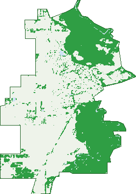
Green: 10 m cells where trees dominate, satellite 2021. Blue: water. The line is the suburb boundary.
| Canopy share, 1 m canopy height map, 2020 | 29.5% |
|---|---|
| Land with trees, 10 m satellite map, 2021 | 37.4% |
Demographics
Unemployment 5.7% · Labour-force participation 50.5%
Population by age in Mooroopna
| 0-4 | 435 |
|---|---|
| 5-14 | 962 |
| 15-19 | 463 |
| 20-24 | 507 |
| 25-34 | 1,060 |
| 35-44 | 886 |
| 45-54 | 1,031 |
| 55-64 | 1,058 |
| 65-74 | 1,043 |
| 75-84 | 624 |
| 85+ | 238 |
Dwelling types in Mooroopna
| House | 2,648 |
|---|---|
| Townhouse | 433 |
| Apartment | 13 |
| Other | 188 |
Households by weekly income in Mooroopna
| <$650 | 796 |
|---|---|
| $650-1,499 | 1,132 |
| $1,500-2,999 | 824 |
| $3,000+ | 286 |
Top ancestries in Mooroopna
| English | 3,157 |
|---|---|
| Australian | 3,008 |
| Irish | 898 |
| Ancestry NS | 851 |
| Scottish | 824 |
| Aboriginal | 587 |
Housing tenure in Mooroopna
| Owned | 1,143 |
|---|---|
| Mortgage | 996 |
| Rented | 1,010 |
| Other | 58 |
Cars per household in Mooroopna
| 0 | 223 |
|---|---|
| 1 | 1,283 |
| 2 | 1,099 |
| 3 | 419 |
| 4+ | 188 |
Commute to work in Mooroopna
| Car | 2,591 |
|---|---|
| Train | 0 |
| Bus | 9 |
| Tram/ferry | 0 |
| Walked | 50 |
| Bicycle | 20 |
| Home | 216 |
Top countries of birth in Mooroopna
| England | 151 |
|---|---|
| India | 95 |
| Philippines | 77 |
| Italy | 67 |
| New Zealand | 67 |
| Malaysia | 59 |
Languages used at home in Mooroopna
| Punjabi | 76 |
|---|---|
| Italian | 75 |
| Mandarin | 58 |
| Turkish | 53 |
| Tagalog | 40 |
| Thai | 30 |
Birds & Wildlife Nearby
127,735 bird observations recorded near Mooroopna — most often seen:
- Noisy Miner (7,654)
- Crested Pigeon (6,854)
- Galah (6,553)
- Sulphur-crested Cockatoo (6,527)
- Eastern Rosella (5,724)
- Welcome Swallow (5,556)
- Rainbow Lorikeet (5,464)
- Australian Raven (5,387)
- Australian Magpie (5,194)
- Magpie-lark (4,985)
- Red Wattlebird (4,923)
- Eurasian Blackbird (4,736)
- Long-billed Corella (4,668)
Show all 30 birds recorded near Mooroopna
- Pacific Black Duck (3,976)
- Superb Fairy-wren (3,784)
- Laughing Kookaburra (3,779)
- White-plumed Honeyeater (3,568)
- Little Raven (3,401)
- Australian Wood Duck (3,374)
- House Sparrow (3,288)
- Common Myna (3,179)
- Blue-faced Honeyeater (3,175)
- Mistletoebird (2,909)
- Willie Wagtail (2,896)
- Weebill (2,811)
- Australian White Ibis (2,747)
- White-faced Heron (2,740)
- Grey Shrike-thrush (2,683)
- Coastal Spotted Pardalote (2,661)
- Dusky Moorhen (2,539)
Sightings reported by observers, not a survey, so the counts show what people record rather than what lives here. Source: Atlas of Living Australia.
Nearby Suburbs
The closest suburbs to Mooroopna:
- Ardmona (4.2 km)
- Shepparton (5.2 km)
- Kialla (6 km)
- Tatura East (7.7 km)
- Shepparton North (7.8 km)
- Mooroopna North (7.8 km)
- Grahamvale (8.9 km)
- Orrvale (9 km)
Embed this suburb
Add this free Mooroopna stat card to your own site — just copy the code:
Preview:
Cite this page
Quoting these figures? Copy the credit line:
Keep an eye on Mooroopna
One email when this data meaningfully changes — new census figures, prices, rankings. No spam, unsubscribe anytime.
Streets
- Aberdeen Street (8)
- Agnew Street (12)
- Ainslie Court (3)
- Albert Street (2)
- Alexandra Street (40)
- Allana Court (6)
- Anderson Street (23)
- Angus Court (13)
- Ann Street (35)
- Anselmi Street (9)
- Archer Street (10)
- Arrowsmith Crescent (24)
- Baker Crescent (38)
- Balding Court (10)
- Banfield Avenue (41)
- Barbara Court (7)
- Baydene Terrace (10)
- Beattie Court (24)
- Bellemara Drive (38)
- Bennett Court (9)
- Blacksmith Avenue (9)
- Bolt Street (5)
- Bramley Court (8)
- Brennan Street (1)
- Broadbent Court (8)
- Brook Court (4)
- Camp Street (8)
- Campbell Court (7)
- Carr Crescent (50)
- Castlebrite Street (16)
- Cemetery Road (4)
- Centennial Drive (29)
- Charles Street (68)
- Chivalry Drive (48)
- Clydesdale Court (20)
- Coe Court (13)
- Cornish Road (32)
- Craigmuir Drive (31)
- Crane Court (14)
- Crerar Court (12)
- Crusader Avenue (9)
- Daisy Street (60)
- Darcy Court (7)
- Dennison Street (24)
- Dolton Court (8)
- Doonan Street (2)
- Dowson Place (5)
- Ducat Court (10)
- Echuca Road (225)
- Elizabeth Street (102)
- Elsie Jones Drive (74)
- Elvin Court (4)
- Emma Street (89)
- Excelsior Avenue (18)
- Fairway Drive (32)
- Feather Drive (13)
- Ferguson Road (8)
- Fletcher Avenue (13)
- Flint Way (6)
- Florance Court (8)
- Freer Court (15)
- Friend Street (12)
- Gange Street (76)
- Gemmill Crescent (26)
- Gerrish Court (19)
- Gillieston Court (12)
- Glenda Anne Court (9)
- Glenn Erin Court (11)
- Goulburn Cross (19)
- Graeme Street (56)
- Grant Street (2)
- Greencastle Court (19)
- Hall Street (83)
- Harding Street (5)
- Hawking Court (13)
- Heily Avenue (10)
- Helmer Street (60)
- Henleydale Drive (22)
- Homewood Drive (109)
- Howe Street (29)
- Huggard Drive (9)
- Hutchins Crescent (28)
- Isaacs Street (23)
- Jackavin Court (8)
- Jacobson Street (31)
- John Gray Avenue (15)
- John Street (5)
- Joseph Street (6)
- Kaeila Court (4)
- Kalimna Drive (67)
- Knight Street (185)
- Lakeview Place (16)
- Lansdowne Court (16)
- Larsen Street (15)
- Lawson Street (1)
- Lenne Street (96)
- Lewis Court (6)
- Little Road (5)
- Macisaac Road (173)
- Mackellar Crescent (47)
- Madge Court (37)
- Maher Court (10)
- Manfred Place (6)
- Maycrest Road (2)
- Mcfarlane Road (57)
- Mckean Street (136)
- Mckenzie Court (7)
- Mclennan Street (259)
- Mcmiken Court (11)
- Medieval Crescent (16)
- Menzies Street (19)
- Midland Highway (240)
- Mill Street (14)
- Millar Court (15)
- Montana Court (17)
- Montrose Court (7)
- Mooredge Place (9)
- Morrell Street (58)
- Mundoona Court (18)
- Musgrove Drive (18)
- Nello Court (11)
- Nightingale Close (9)
- Northgate Street (65)
- Norton Drive (43)
- Obrien Street (66)
- Opalite Court (8)
- Paisley Crescent (37)
- Palace Street (13)
- Park Street (33)
- Parsons Court (15)
- Pell Crescent (63)
- Price Street (8)
- Pyke Road (17)
- Quiver Terrace (8)
- Radford Close (6)
- Rainboy Court (13)
- Reid Street (25)
- Richard Court (7)
- Robert Close (4)
- Rodney Park Avenue (19)
- Rosalind Street (41)
- Ross Street (34)
- Rostrata Crescent (30)
- Rumbalara Road (6)
- Sellwood Court (12)
- Shaft Street (2)
- Shannon Court (9)
- Simson Road (3)
- Sirena Place (3)
- Sophie Court (6)
- Spinwig Terrace (9)
- Spinwing Terrace (13)
- Stanley Street (7)
- Stevens Crescent (37)
- Sun Court (4)
- Sunflower Drive (17)
- Sunnybrook Crescent (1)
- Toolamba Road (77)
- Tournament Drive (30)
- Tower Street (9)
- Treacy Street (8)
- Trinket Court (7)
- Tulip Street (17)
- Turnbull Road (2)
- Tylabelle Terrace (21)
- Victoria Street (4)
- Violet Street (22)
- Westview Drive (23)
- Westwood Drive (42)
- William Street (25)
- Wilma Court (8)
- Windlass Avenue (57)
- Winolite Court (8)
- Wishaw Court (5)
- Wood Street (16)
- Young Street (13)