Manor Lakes VIC 3024
6,839 addresses · 317 streets
Lalor Electorate › Wyndham LGA › Manor Lakes · 33 km from Melbourne
📦 Thinking of moving here? Read the Manor Lakes moving guide

Living Here
Manor Lakes is a suburb of Victoria, home to about 12,675 people, with a median age of 31. The typical household earns around $2,296 a week, with median rent near $360 a week. Most homes are houses. About 73% of households own their home and 27% rent. Most workers drive to work. Common community backgrounds include Indian, Australian, English. On the ABS socio-economic scale it sits in decile 8 of 10 nationally — a relatively advantaged area. The median house sells for about $640,000.
Getting Around & Local Services
3 cafés & restaurants
5 supermarkets
1 Catholic church
1 medical clinic
1 gym
1 golf club
1 playground
1 dog park
1 hardware store
1 mechanic
1 electrician
Getting around. Train station: Wyndham Vale, 1.3 km east · Bus interchange: Safari Station, 8.5 km south-east · Airport: Avalon Airport, 20.9 km south-west.
Sport & Recreation
2 facilities recorded in Manor Lakes.
- Howqua Way Reserve Australian Rules Football, Cricket
- Manor Lake Fitness Aerobics, Fitness / Gymnasium Workouts
Socio-economic Standing
Deciles from 1 (lowest) to 10 (highest), against all Australian suburbs. The overall figure weighs advantage and disadvantage together; economic resources counts income and housing, and education & jobs counts qualifications and occupation. They often differ. Source: ABS SEIFA 2021.
Median Sale Prices
Median of recorded sales in the period, not a valuation. Source: Victorian Property Sales Report, Land Use Victoria.
Tree cover
🌳 Tree canopy: 1.4% share of land under canopy · satellite map, 2020
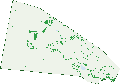
Green: 10 m cells where trees dominate, satellite 2021. Blue: water. The line is the suburb boundary.
| Canopy share, 1 m canopy height map, 2020 | 1.4% |
|---|---|
| Land with trees, 10 m satellite map, 2021 | 4.0% |
Demographics
Unemployment 6.3% · Labour-force participation 73.6%
Population by age in Manor Lakes
| 0-4 | 1,354 |
|---|---|
| 5-14 | 2,416 |
| 15-19 | 748 |
| 20-24 | 633 |
| 25-34 | 2,241 |
| 35-44 | 2,936 |
| 45-54 | 1,224 |
| 55-64 | 611 |
| 65-74 | 341 |
| 75-84 | 119 |
| 85+ | 50 |
Dwelling types in Manor Lakes
| House | 3,527 |
|---|---|
| Townhouse | 187 |
| Apartment | 0 |
| Other | 0 |
Households by weekly income in Manor Lakes
| <$650 | 199 |
|---|---|
| $650-1,499 | 695 |
| $1,500-2,999 | 1,522 |
| $3,000+ | 1,077 |
Top ancestries in Manor Lakes
| Other | 3,608 |
|---|---|
| Indian | 3,239 |
| Australian | 2,252 |
| English | 2,059 |
| Ancestry NS | 659 |
| Filipino | 587 |
Housing tenure in Manor Lakes
| Owned | 291 |
|---|---|
| Mortgage | 2,363 |
| Rented | 976 |
| Other | 25 |
Cars per household in Manor Lakes
| 0 | 99 |
|---|---|
| 1 | 1,548 |
| 2 | 1,489 |
| 3 | 380 |
| 4+ | 146 |
Commute to work in Manor Lakes
| Car | 2,788 |
|---|---|
| Train | 330 |
| Bus | 23 |
| Tram/ferry | 0 |
| Walked | 42 |
| Bicycle | 9 |
| Home | 2,014 |
Top countries of birth in Manor Lakes
| India | 3,290 |
|---|---|
| Philippines | 410 |
| New Zealand | 361 |
| England | 161 |
| Sri Lanka | 156 |
| Bangladesh | 135 |
Languages used at home in Manor Lakes
| Hindi | 957 |
|---|---|
| Punjabi | 856 |
| Tamil | 401 |
| Gujarati | 308 |
| Bengali | 213 |
| Tagalog | 202 |
Birds & Wildlife Nearby
6,107 bird observations recorded near Manor Lakes — most often seen:
- Australian Magpie (355)
- Common Starling (349)
- House Sparrow (346)
- Willie Wagtail (314)
- Magpie-lark (310)
- Little Raven (297)
- Common Myna (294)
- Pacific Black Duck (275)
- Red Wattlebird (230)
- Superb Fairy-wren (214)
- Welcome Swallow (207)
- White-plumed Honeyeater (199)
- Spotted Turtle-dove (191)
Show all 30 birds recorded near Manor Lakes
- Eurasian Blackbird (188)
- Eurasian Coot (168)
- Crested Pigeon (166)
- European Goldfinch (164)
- Masked Lapwing (161)
- Rainbow Lorikeet (160)
- White-faced Heron (160)
- Black Swan (156)
- Dusky Moorhen (151)
- New Holland Honeyeater (144)
- Chestnut Teal (141)
- Eurasian Skylark (141)
- Straw-necked Ibis (132)
- Australasian Purple Swamphen (131)
- Galah (122)
- Australian White Ibis (121)
- Red-rumped Parrot (120)
Sightings reported by observers, not a survey, so the counts show what people record rather than what lives here. Source: Atlas of Living Australia.
Nearby Suburbs
The closest suburbs to Manor Lakes:
- Wyndham Vale (2 km)
- Mambourin (2.3 km)
- Werribee (5.8 km)
- Tarneit (7.4 km)
- Cocoroc (7.6 km)
- Quandong (7.7 km)
- Mount Cottrell (8.4 km)
- Hoppers Crossing (8.7 km)
Embed this suburb
Add this free Manor Lakes stat card to your own site — just copy the code:
Preview:
Cite this page
Quoting these figures? Copy the credit line:
Keep an eye on Manor Lakes
One email when this data meaningfully changes — new census figures, prices, rankings. No spam, unsubscribe anytime.
Streets
- Academy Way (2)
- Adon Walk (5)
- Afton Way (5)
- Agnes Place (2)
- Akron Street (26)
- Alberga Way (5)
- Allspice Street (21)
- Amadeus Street (13)
- Amaretto Circuit (36)
- Ampelon Street (8)
- Anisata Way (27)
- Ardisia Way (19)
- Ardsley Street (43)
- Argoona Road (2)
- Arkport Way (4)
- Armstrong Road (89)
- Arrowhead Street (32)
- Ashburton Avenue (21)
- Athletic Avenue (2)
- Baikal Crescent (9)
- Bainbridge Road (22)
- Balcombe Drive (29)
- Ballan Road (90)
- Barcoo Street (18)
- Barmah Street (8)
- Barossa Drive (23)
- Battersea Street (1)
- Bellfield Court (17)
- Berryessa Way (2)
- Bertie Street (35)
- Bindarri Road (27)
- Biscotti Crescent (21)
- Bixa Walk (8)
- Blackberry Street (20)
- Blasdell Street (15)
- Bloomingburg Road (25)
- Blowering Street (11)
- Blue Gum Mews (3)
- Boga Place (15)
- Bold Mews (7)
- Bombax Street (22)
- Bondon Crescent (11)
- Bonhams Circuit (40)
- Bonney Street (3)
- Bookar Place (11)
- Bow Crescent (11)
- Bregman Esplanade (50)
- Brittle Street (23)
- Broadwater Street (12)
- Brockwell Crescent (41)
- Brocton Road (13)
- Brumby Street (20)
- Brushton Street (21)
- Buffalo Crescent (9)
- Buloke Avenue (15)
- Bulrush Retreat (2)
- Bungalook Street (23)
- Burdekin Street (11)
- Burley Court (9)
- Burrendong Street (9)
- Burrumbeet Court (9)
- Bush Street (29)
- Buttermint Crescent (24)
- Butterscotch Esplanade (30)
- Calden Street (3)
- Canons Crescent (11)
- Cardinia Grove (21)
- Cassata Road (21)
- Caverns Street (20)
- Chai Walk (12)
- Cherrywood Avenue (21)
- Chutney Street (10)
- Clarence Street (17)
- Clematis Crescent (33)
- Coconut Road (18)
- Cogley Street (15)
- Colonie Street (1)
- Comb Street (25)
- Commuter Boulevard (1)
- Condamine Avenue (26)
- Connewarre Close (21)
- Cooma Street (12)
- Cootharaba Street (4)
- Corinth Street (26)
- Corkwood Road (1)
- Cornubia Road (20)
- Cotton Street (8)
- Cradle Circuit (43)
- Cranberry Crescent (32)
- Creekside Boulevard (20)
- Custard Way (6)
- Cyad Way (37)
- Dalrymple Boulevard (15)
- Darling Place (14)
- Dartmouth Court (13)
- Dawson Crescent (25)
- Desert Gum Terrace (13)
- Dewberry Street (13)
- Draft Street (13)
- Drover Avenue (20)
- Dryandra Street (31)
- Dryden Avenue (19)
- Dulcis Street (32)
- Dutch Avenue (26)
- Earlville Street (18)
- Eclair Street (22)
- Edenvale Street (25)
- Edwin Close (27)
- Eildon Avenue (33)
- Elbridge Road (5)
- Elderflower Street (21)
- Ellenborough Crescent (18)
- Ellisburg Street (28)
- Ellisburg Street Street (28)
- Eltham Parade (79)
- Eppalock Drive (51)
- Eucumbene Road (30)
- Eureka Drive (123)
- Fabius Way (12)
- Farmingdale Street (24)
- Fawkner Road (21)
- Field Street (23)
- Fig Street (4)
- Finsbury Crescent (32)
- Firecrest Road (36)
- Forest Gum Mews (3)
- Fortescue Boulevard (17)
- Fragrance Terrace (18)
- Franfort Road (1)
- Fudge Street (7)
- Gairdner Street (23)
- Galbra Walk (4)
- Galway Street (9)
- Gelati Street (23)
- Gembrook Street (10)
- Glenmaggie Place (11)
- Goodenia Avenue (26)
- Graded Street (19)
- Granita Street (11)
- Granville Street (28)
- Groton Street (8)
- Grovedale Way (37)
- Guava Road (1)
- Gunyong Crescent (21)
- Hawkstone Road (55)
- Hazelnut Road (22)
- Heathcote Road (35)
- Hindmarsh Drive (56)
- Hoddle Link (16)
- Holloway Street (25)
- Holyoake Parade (105)
- Honeyblossom Street (16)
- Honeycomb Avenue (39)
- Hovea Crescent (16)
- Howqua Way (5)
- Huron Road (14)
- Interlaken Avenue (20)
- Irvington Road (22)
- Ison Road (136)
- Ixora Crescent (26)
- Jackaroo Street (14)
- Jackeroo Street (14)
- Jaffa Road (8)
- Jardine Street (15)
- Jube Walk (8)
- Judd Street (16)
- Julep Road (1)
- Julep Street (17)
- Jumps Street (16)
- Kanto Court (3)
- Kaser Street (11)
- Kinglake Drive (129)
- Kinnick Street (5)
- Koomba Street (8)
- Kumara Drive (39)
- Kutjera Street (26)
- Lacona Road (4)
- Lambertia Crescent (30)
- Lancewood Road (50)
- Landmark Crescent (12)
- Leger Road (10)
- Leger Street (29)
- Leichardt Drive (25)
- Lenigas Crescent (24)
- Limewood Street (22)
- Lindberg Street (15)
- Liquorice Street (4)
- Loganberry Road (24)
- Longanberry Road (7)
- Lough Way (6)
- Lynwood Street (11)
- Lysterfield Walk (5)
- Mackay Road (17)
- Maclarens Close (31)
- Maculata Place (22)
- Madeira Street (13)
- Malt Drive (20)
- Manifera Close (10)
- Manor Lakes Boulevard (170)
- Maracaibo Crescent (29)
- Maracana Avenue (138)
- Marcellus Street (10)
- Marmalade Road (25)
- Marsdenia Street (31)
- Mayesbrook Road (33)
- Maywood Road (76)
- Mchaffie Terrace (8)
- Medlar Avenue (30)
- Meema Crescent (9)
- Melliodora Court (23)
- Mentha Street (23)
- Merri Street (11)
- Mersin Crescent (23)
- Michigan Crescent (22)
- Michigan Street (21)
- Miniata Way (35)
- Minindee Road (35)
- Minoa Road (5)
- Mokoan Close (9)
- Mondra Terrace (14)
- Mountain Avenue (29)
- Mulwala Court (11)
- Mundi Crescent (33)
- Murdeduke Crescent (11)
- Murrumbidgee Street (29)
- Muscatel Crescent (24)
- Muscatel Street (15)
- Musk Place (5)
- Muster Street (17)
- Neagh Street (9)
- Nectar Avenue (27)
- Nelumbo Street (12)
- Ness Mews (3)
- Nichollii Court (8)
- Nitre Street (23)
- Nunda Way (10)
- Nutmeg Parade (22)
- Omeo Terrace (18)
- Orvalia Road (12)
- Owego Road (6)
- Padlu Street (8)
- Pandan Walk (9)
- Papaya Walk (10)
- Pastille Road (30)
- Pedder Street (31)
- Pepita Crescent (25)
- Peppermint Crescent (20)
- Pierbrook Avenue (24)
- Pinhook Street (25)
- Pittsford Road (10)
- Porto Road (40)
- Portulaca Avenue (23)
- Praline Street (26)
- Prune Walk (9)
- Punica Street (9)
- Quince Road (9)
- Radiata Close (9)
- Rhubarb Road (19)
- Richburg Road (15)
- Ricotta Road (17)
- Rondo Drive (89)
- Roper Court (8)
- Rosewater Street (37)
- Rush Crescent (7)
- Salvinia Street (3)
- Sapium View (29)
- Saris Street (6)
- Savona Way (10)
- Scholar Drive (11)
- Semolina Street (28)
- Shire Street (15)
- Shoreham Road (23)
- Silver Gum Street (34)
- Sparland Street (17)
- Spearmint Boulevard (92)
- Springwood Terrace (16)
- Stakes Boulevard (31)
- Stony Street (6)
- Stork Street (17)
- Strawberry Road (22)
- Stringybark Close (26)
- Strudel Road (9)
- Sugarlea Street (22)
- Superior Street (19)
- Swansea Road (20)
- Sweet Street (6)
- Swiss Way (18)
- Syrup Road (5)
- Tahini Walk (12)
- Tangerine Road (28)
- Tapioca Street (24)
- Tecoma Street (35)
- Tenax Walk (4)
- Toolibin Street (21)
- Treacle Road (6)
- Truffle Circuit (28)
- Tyrrell Place (1)
- Uralla Street (21)
- Varna Way (7)
- Vasity Mews (3)