Lynbrook VIC 3975
3,328 addresses · 148 streets
Holt Electorate › Casey LGA › Lynbrook · 37 km from Melbourne
📦 Thinking of moving here? Read the Lynbrook moving guide

Living Here
Lynbrook is a suburb of Victoria, home to about 9,121 people, with a median age of 33. The typical household earns around $2,212 a week, with median rent near $401 a week. Most homes are houses. About 79% of households own their home and 21% rent. Most workers drive to work. Common community backgrounds include Indian, Australian, English. On the ABS socio-economic scale it sits in decile 6 of 10 nationally — a mid-range area. The median house sells for about $797,500.
Over time — Census 2001 → 2021
Dashed line: district figures for the Lynbrook - Lyndhurst statistical area (SA2), the smallest area the ABS published before 2011. Solid line: Lynbrook itself.
Getting Around & Local Services
3 doctors & medical clinics
2 dentists
1 optometrist
12 childcare & kindergartens
- Lynbrook Children's Centre
- Fern Early Learning Centre Hampton Park
- Coral Drive Childrens Centre
- Green Kids Early Learning Centre
- Goodstart Early Learning
- Bright Kids Family Day Care
- Great Beginnings Lyndhurst
- ABC Learning Centre - Sherwood Road
- Merinda Park Learning and Community Center
- Strathaird Children's Centre
2 libraries
1 post office
3 gyms & sports centres
1 dog park
2 butchers
1 beauty salon
2 electricians
1 plumber
Getting around. Train station: Lynbrook, 700 m south-west · Bus interchange: Fountain Gate SC, 5.7 km north-east · Airport: Moorabbin Airport, 16.1 km north-west.
Sport & Recreation
1 facility recorded in Lynbrook.
- Banjo Patterson Park Australian Rules Football, BMX, Basketball, Cricket
Socio-economic Standing
Deciles from 1 (lowest) to 10 (highest), against all Australian suburbs. The overall figure weighs advantage and disadvantage together; economic resources counts income and housing, and education & jobs counts qualifications and occupation. They often differ. Source: ABS SEIFA 2021.
Median Sale Prices
Median of recorded sales in the period, not a valuation. Source: Victorian Property Sales Report, Land Use Victoria.
Tree cover
🌳 Tree canopy: 10% share of land under canopy · satellite map, 2020
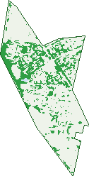
Green: 10 m cells where trees dominate, satellite 2021. Blue: water. The line is the suburb boundary.
| Canopy share, 1 m canopy height map, 2020 | 10.0% |
|---|---|
| Land with trees, 10 m satellite map, 2021 | 21.8% |
Demographics
Unemployment 6% · Labour-force participation 65.8%
Population by age in Lynbrook
| 0-4 | 659 |
|---|---|
| 5-14 | 1,452 |
| 15-19 | 639 |
| 20-24 | 700 |
| 25-34 | 1,249 |
| 35-44 | 1,439 |
| 45-54 | 1,280 |
| 55-64 | 873 |
| 65-74 | 473 |
| 75-84 | 220 |
| 85+ | 139 |
Dwelling types in Lynbrook
| House | 2,252 |
|---|---|
| Townhouse | 163 |
| Apartment | 28 |
| Other | 0 |
Households by weekly income in Lynbrook
| <$650 | 167 |
|---|---|
| $650-1,499 | 506 |
| $1,500-2,999 | 978 |
| $3,000+ | 607 |
Top ancestries in Lynbrook
| Other | 3,673 |
|---|---|
| Indian | 1,534 |
| Australian | 1,194 |
| English | 1,165 |
| Chinese | 516 |
| Ancestry NS | 490 |
Housing tenure in Lynbrook
| Owned | 454 |
|---|---|
| Mortgage | 1,430 |
| Rented | 498 |
| Other | 11 |
Cars per household in Lynbrook
| 0 | 61 |
|---|---|
| 1 | 564 |
| 2 | 1,078 |
| 3 | 430 |
| 4+ | 264 |
Commute to work in Lynbrook
| Car | 2,816 |
|---|---|
| Train | 115 |
| Bus | 21 |
| Tram/ferry | 0 |
| Walked | 24 |
| Bicycle | 7 |
| Home | 764 |
Top countries of birth in Lynbrook
| India | 1,466 |
|---|---|
| Sri Lanka | 563 |
| Afghanistan | 449 |
| New Zealand | 220 |
| China | 195 |
| Cambodia | 174 |
Languages used at home in Lynbrook
| Punjabi | 683 |
|---|---|
| Sinhalese | 484 |
| Hindi | 373 |
| Mandarin | 250 |
| Malayalam | 243 |
| Tamil | 214 |
Birds & Wildlife Nearby
52,471 bird observations recorded near Lynbrook — most often seen:
- Common Myna (2,880)
- Little Raven (2,831)
- Common Starling (2,732)
- Pacific Black Duck (2,547)
- Eurasian Blackbird (2,365)
- Australasian Purple Swamphen (2,343)
- Australian White Ibis (2,275)
- Eurasian Coot (2,135)
- Dusky Moorhen (2,015)
- Magpie-lark (1,956)
- White-faced Heron (1,808)
- House Sparrow (1,742)
- Rainbow Lorikeet (1,701)
Show all 30 birds recorded near Lynbrook
- Spotted Turtle-dove (1,658)
- Australian Magpie (1,635)
- Little Pied Cormorant (1,602)
- Welcome Swallow (1,472)
- Red Wattlebird (1,463)
- Australian Wood Duck (1,445)
- Chestnut Teal (1,437)
- Black Swan (1,375)
- White-plumed Honeyeater (1,333)
- Noisy Miner (1,326)
- European Goldfinch (1,324)
- Southern Victoria Australian Magpie (1,313)
- Silver Gull (1,180)
- Willie Wagtail (1,178)
- Grey Teal (1,155)
- Superb Fairy-wren (1,124)
- Little Black Cormorant (1,121)
Sightings reported by observers, not a survey, so the counts show what people record rather than what lives here. Source: Atlas of Living Australia.
Nearby Suburbs
The closest suburbs to Lynbrook:
- Lyndhurst (1.7 km)
- Hampton Park (2.2 km)
- Narre Warren South (4 km)
- Cranbourne North (4.6 km)
- Dandenong South (4.9 km)
- Cranbourne West (5.2 km)
- Sandhurst (5.5 km)
- Bangholme (5.5 km)
Embed this suburb
Add this free Lynbrook stat card to your own site — just copy the code:
Preview:
Cite this page
Quoting these figures? Copy the credit line:
Keep an eye on Lynbrook
One email when this data meaningfully changes — new census figures, prices, rankings. No spam, unsubscribe anytime.
Streets
- Aisbett Close (29)
- Alfonso Court (8)
- Alkoomi Court (10)
- Amy Mack Walk (4)
- Andretti Avenue (37)
- Astley Wynd (53)
- Aylmer Road (65)
- Banjo Circuit (50)
- Bay Laurel Close (11)
- Baynton Crescent (40)
- Beaver Terrace (8)
- Bingham Rise (12)
- Blue Range Crescent (27)
- Bodhran Place (7)
- Boldrewood Place (17)
- Bollinger Lane (1)
- Bonwick Close (8)
- Boothby Terrace (17)
- Braddon Way (7)
- Brady Close (14)
- Buckley Way (10)
- Bushman Way (16)
- Business Park Drive (10)
- Campion Walk (4)
- Carboni Crescent (40)
- Cathedral Court (10)
- Cato Parkway (53)
- Caversham Terrace (46)
- Chapel Street (24)
- Charlwood Close (15)
- Chauncy Way (17)
- Cilento Crescent (119)
- Cobbler Grange (28)
- Commercial Drive (49)
- Cottrell Place (7)
- Cusack Way (6)
- Damper Way (15)
- Dandenong-hastings Road (9)
- Darcy Niland Crescent (18)
- Daylillies Court (3)
- Dennis Close (15)
- Devaney Avenue (21)
- Dobson Crescent (8)
- Durack Avenue (23)
- Dutton Close (30)
- Dyson Drive (13)
- Eaglecrest Drive (1)
- Eldershaw Drive (36)
- Elliott Parade (72)
- Elphin Close (14)
- Endeavour Drive (1)
- Epsilon Way (13)
- Ethel Turner Place (3)
- Evans Road (88)
- Forbes Avenue (21)
- Franklin Parade (50)
- Gardens Vista Place (6)
- Gilmore Crescent (58)
- Glenbrook Crescent (28)
- Glenshee Drive (28)
- Gordal Court (4)
- Guru Boulevard (58)
- Hal Porter Terrace (54)
- Hallam Road (6)
- Hanrahan Wynd (25)
- Harford Close (16)
- Harris Street (30)
- Hasluck Crescent (24)
- Henning Avenue (14)
- Henry Lawson Drive (55)
- Hinterland Close (21)
- Hopegood Place (11)
- Hutchinson Drive (93)
- Kalamata Avenue (11)
- Keystone Court (10)
- Kingsfield Crescent (24)
- Kingsley Court (6)
- Lemon Thyme Way (28)
- Lindsay Crescent (30)
- Litchfield Way (10)
- Livingstone Rise (6)
- Lockwood Rise (29)
- Louise Mack Walk (4)
- Love Street (14)
- Lower Mews (10)
- Lynbrook Boulevard (95)
- Macleod Way (11)
- Manzanilla Way (9)
- Matilda Court (11)
- May Gibbs Crescent (50)
- Mckern Place (4)
- Mercer Place (2)
- Meribel Way (10)
- Mission Court (10)
- Morrant Mews (10)
- Morris West Circuit (21)
- Northey Road (32)
- Nugong Place (9)
- Odowd Place (12)
- Olive Road (38)
- Oregano Drive (16)
- Oreilly Court (15)
- Pagefield Place (26)
- Park City Drive (13)
- Parnum Place (2)
- Parslow Crescent (18)
- Paterson Drive (172)
- Pedley Way (6)
- Penton Way (42)
- Pimelea Avenue (5)
- Prichard Avenue (17)
- Rankin Close (31)
- Ratcliffe Way (28)
- Raylee Place (18)
- River Redgum Place (2)
- Ronans Retreat (15)
- Rowcroft Avenue (19)
- Rudd Court (16)
- Sansom Close (3)
- Sedgwick Court (19)
- Selma Close (19)
- Settlers Lane (1)
- Silver Creek Drive (32)
- Silvertop Close (6)
- Slessor Avenue (16)
- Snowy Drive (17)
- South Gippsland Highway (27)
- Speranza Place (19)
- St Bernards Crescent (27)
- Stelvio Close (24)
- Sugar Bush Drive (25)
- Sugarloaf Avenue (26)
- Sun Valley Boulevard (8)
- Tapas Court (4)
- Tarragon Court (11)
- Tembie Rise (5)
- Tennant Court (6)
- Thiele Court (8)
- Tilly Place (9)
- Towerhill Boulevard (16)
- Tranter Square (23)
- Upfield Walk (6)
- Vine Circuit (32)
- Wallaby Walk (1)
- Wally Place (48)
- Waltzing Drive (24)
- Wattletree Place (26)
- Zain Street (9)