Lower Plenty VIC 3093
1,983 addresses · 61 streets
Jagajaga Electorate › Banyule LGA › Lower Plenty · 17 km from Melbourne
📦 Thinking of moving here? Read the Lower Plenty moving guide

Living Here
Lower Plenty is a suburb of Victoria, home to about 3,962 people, with a median age of 45. The typical household earns around $2,160 a week, with median rent near $400 a week. Most homes are houses. About 84% of households own their home and 15% rent. Most workers drive to work. Common community backgrounds include English, Australian, Irish. On the ABS socio-economic scale it sits in decile 10 of 10 nationally — a relatively advantaged area. The median house sells for about $1,340,000.
Over time — Census 2001 → 2021
Dashed line: district figures for the Montmorency - Briar Hill statistical area (SA2), the smallest area the ABS published before 2011. Solid line: Lower Plenty itself.
Getting Around & Local Services
3 physiotherapists
2 playgrounds
3 beauty salons
2 electricians
1 carpenter
Getting around. Train station: Montmorency, 1.6 km north · Railway halt: Box Hill, 7.8 km south · Bus interchange: Doncaster Shopping Centre, 6.1 km south · Airport: Essendon Fields Airport, 19.2 km west.
Sport & Recreation
3 facilities recorded in Lower Plenty.
- Glenauburn Reserve Baseball, Cricket
- Heidelberg Golf Club Golf, Lawn Bowls
- Rosanna Golf Club Golf
Socio-economic Standing
Deciles from 1 (lowest) to 10 (highest), against all Australian suburbs. The overall figure weighs advantage and disadvantage together; economic resources counts income and housing, and education & jobs counts qualifications and occupation. They often differ. Source: ABS SEIFA 2021.
Median Sale Prices
Median of recorded sales in the period, not a valuation. Source: Victorian Property Sales Report, Land Use Victoria.
Tree cover
🌳 Tree canopy: 27.5% share of land under canopy · satellite map, 2020
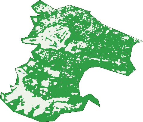
Green: 10 m cells where trees dominate, satellite 2021. Blue: water. The line is the suburb boundary.
| Canopy share, 1 m canopy height map, 2020 | 27.5% |
|---|---|
| Land with trees, 10 m satellite map, 2021 | 72.5% |
Demographics
Unemployment 3.9% · Labour-force participation 61.5%
Population by age in Lower Plenty
| 0-4 | 191 |
|---|---|
| 5-14 | 469 |
| 15-19 | 233 |
| 20-24 | 197 |
| 25-34 | 378 |
| 35-44 | 483 |
| 45-54 | 584 |
| 55-64 | 513 |
| 65-74 | 466 |
| 75-84 | 303 |
| 85+ | 150 |
Dwelling types in Lower Plenty
| House | 1,107 |
|---|---|
| Townhouse | 308 |
| Apartment | 57 |
| Other | 0 |
Households by weekly income in Lower Plenty
| <$650 | 148 |
|---|---|
| $650-1,499 | 349 |
| $1,500-2,999 | 422 |
| $3,000+ | 470 |
Top ancestries in Lower Plenty
| English | 1,473 |
|---|---|
| Australian | 1,280 |
| Irish | 523 |
| Scottish | 492 |
| Italian | 434 |
| Other | 377 |
Housing tenure in Lower Plenty
| Owned | 648 |
|---|---|
| Mortgage | 575 |
| Rented | 217 |
| Other | 13 |
Cars per household in Lower Plenty
| 0 | 37 |
|---|---|
| 1 | 457 |
| 2 | 635 |
| 3 | 170 |
| 4+ | 160 |
Commute to work in Lower Plenty
| Car | 950 |
|---|---|
| Train | 15 |
| Bus | 6 |
| Tram/ferry | 0 |
| Walked | 11 |
| Bicycle | 8 |
| Home | 623 |
Top countries of birth in Lower Plenty
| England | 133 |
|---|---|
| China | 95 |
| Italy | 42 |
| New Zealand | 30 |
| Iran | 27 |
| Scotland | 25 |
Languages used at home in Lower Plenty
| Mandarin | 109 |
|---|---|
| Italian | 63 |
| Greek | 53 |
| Arabic | 36 |
| Persian | 25 |
| Cantonese | 21 |
Birds & Wildlife Nearby
233,342 bird observations recorded near Lower Plenty — most often seen:
- Noisy Miner (14,355)
- Rainbow Lorikeet (13,465)
- Little Raven (12,923)
- Australian Magpie (10,810)
- Common Myna (10,448)
- Sulphur-crested Cockatoo (10,156)
- Magpie-lark (9,730)
- Grey Butcherbird (9,277)
- Pacific Black Duck (9,088)
- Red Wattlebird (8,743)
- Galah (8,364)
- Pied Currawong (7,685)
- Spotted Turtle-dove (7,528)
Show all 30 birds recorded near Lower Plenty
- Laughing Kookaburra (7,291)
- Common Bronzewing (7,194)
- Welcome Swallow (7,160)
- Eastern Rosella (7,071)
- Australian Wood Duck (6,859)
- Dusky Moorhen (6,616)
- Southern Victoria Australian Magpie (6,432)
- Brown Thornbill (6,212)
- Grey Fantail (6,093)
- Superb Fairy-wren (5,980)
- Eurasian Blackbird (5,645)
- Chestnut Teal (5,180)
- Eurasian Coot (5,172)
- Common Starling (4,669)
- Crested Pigeon (4,454)
- Silver Gull (4,371)
- White-browed Scrubwren (4,371)
Sightings reported by observers, not a survey, so the counts show what people record rather than what lives here. Source: Atlas of Living Australia.
Nearby Suburbs
The closest suburbs to Lower Plenty:
- Montmorency (1.3 km)
- Yallambie (1.9 km)
- Viewbank (2.5 km)
- Briar Hill (2.6 km)
- Greensborough (3.3 km)
- Eltham (3.7 km)
- Watsonia (3.7 km)
- Templestowe Lower (4 km)
Embed this suburb
Add this free Lower Plenty stat card to your own site — just copy the code:
Preview:
Cite this page
Quoting these figures? Copy the credit line:
Keep an eye on Lower Plenty
One email when this data meaningfully changes — new census figures, prices, rankings. No spam, unsubscribe anytime.
Streets
- Alma Street (137)
- Amberley Way (11)
- Anthony Close (15)
- Barongarook Court (22)
- Beckett Court (9)
- Beleura Grove (22)
- Bolton Street (7)
- Bonds Road (63)
- Byron Avenue (26)
- Carisbrook Crescent (21)
- Cavanagh Road (8)
- Cheval Court (12)
- Cheverton Road (29)
- Cleveland Avenue (28)
- Cleveland Court (8)
- Coral Court (3)
- Devon Court (12)
- Edward Willis Court (8)
- Edwards Street (55)
- Gees Court (5)
- Geoffrey Court (5)
- Glenauburn Road (58)
- Gwenda Court (5)
- Harcourt Place (5)
- Havelock Court (8)
- Henty Road (2)
- Keating Court (5)
- Kett Street (44)
- Lakeside Drive (26)
- Lees Road (17)
- Leslie Court (11)
- Lincoln Drive (19)
- Longs Road (52)
- Lower Plenty Road (1)
- Lynwood Crescent (20)
- Maida Court (10)
- Main Road (488)
- Maskell Crescent (19)
- Monarch Ridge (18)
- Montpelier Drive (36)
- Old Eltham Road (178)
- Palamino Court (12)
- Panorama Avenue (89)
- Paperbark Court (7)
- Para Road (50)
- Philip Street (39)
- Prosperity Road (13)
- Rangeview Road (35)
- Riverhill Drive (10)
- Roseburn Court (10)
- Rosehill Road (96)
- Sapphire Court (8)
- Sidwell Court (6)
- Stawell Road (8)
- Symes Street (6)
- Towyn Close (6)
- Tyalla Close (6)
- View Road (22)
- Woodfull Road (19)
- Yardie Court (4)
- Yarra Hill Close (9)