Langwarrin VIC 3910
10,964 addresses · 379 streets
Dunkley Electorate › Frankston LGA › Langwarrin · 43 km from Melbourne
📦 Thinking of moving here? Read the Langwarrin moving guide

Living Here
A leafy outer-south-eastern Melbourne suburb near Frankston, Langwarrin is family-oriented with larger blocks. Households average 2.7 people and the median age is 38. Median household income is $1,919 a week, with rent around $365.
Langwarrin is a suburb of Victoria, home to about 23,588 people, with a median age of 38. The typical household earns around $1,919 a week, with median rent near $365 a week. Most homes are houses. About 81% of households own their home and 18% rent. Most workers drive to work. Common community backgrounds include English, Australian, Scottish. On the ABS socio-economic scale it sits in decile 6 of 10 nationally — a mid-range area. The median house sells for about $858,000.
Over time — Census 2001 → 2021
Dashed line: district figures for the Langwarrin statistical area (SA2), the smallest area the ABS published before 2011. Solid line: Langwarrin itself.
Getting Around & Local Services
3 supermarkets
1 Catholic church
4 doctors & medical clinics
1 physiotherapist
2 optometrists
2 childcare & kindergartens
2 post offices
2 butchers
2 hardware stores
2 beauty salons
1 mechanic
1 plumber
Getting around. Train station: Baxter, 5.5 km south-west · Bus interchange: The Explorer, 6.9 km east · Airport: Moorabbin Airport, 21.1 km north-west.
Sport & Recreation
4 facilities recorded in Langwarrin.
- Contours Langwarrin Fitness / Gymnasium Workouts
- Langwarren Basketball Stadium (Elizabeth Murdoch college) Basketball
- Langwarrin Club Grounds Equestrian
- Lloyd Park Australian Rules Football, Cricket, Netball, Tennis (Outdoor)
Socio-economic Standing
Deciles from 1 (lowest) to 10 (highest), against all Australian suburbs. The overall figure weighs advantage and disadvantage together; economic resources counts income and housing, and education & jobs counts qualifications and occupation. They often differ. Source: ABS SEIFA 2021.
Median Sale Prices
Median of recorded sales in the period, not a valuation. Source: Victorian Property Sales Report, Land Use Victoria.
Tree cover
🌳 Tree canopy: 33.4% share of land under canopy · satellite map, 2020
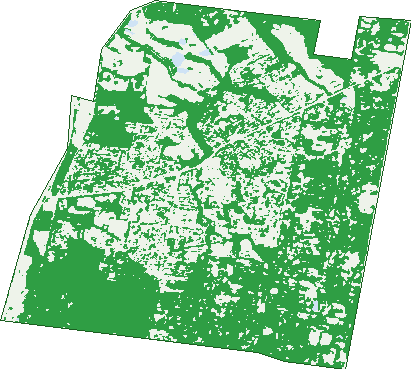
Green: 10 m cells where trees dominate, satellite 2021. Blue: water. The line is the suburb boundary.
| Canopy share, 1 m canopy height map, 2020 | 33.4% |
|---|---|
| Land with trees, 10 m satellite map, 2021 | 62.0% |
Demographics
Unemployment 3.5% · Labour-force participation 68.6%
Population by age in Langwarrin
| 0-4 | 1,519 |
|---|---|
| 5-14 | 3,178 |
| 15-19 | 1,451 |
| 20-24 | 1,297 |
| 25-34 | 3,076 |
| 35-44 | 3,318 |
| 45-54 | 3,205 |
| 55-64 | 2,973 |
| 65-74 | 2,136 |
| 75-84 | 1,079 |
| 85+ | 357 |
Dwelling types in Langwarrin
| House | 7,046 |
|---|---|
| Townhouse | 1,314 |
| Apartment | 14 |
| Other | 147 |
Households by weekly income in Langwarrin
| <$650 | 1,052 |
|---|---|
| $650-1,499 | 2,101 |
| $1,500-2,999 | 3,001 |
| $3,000+ | 1,898 |
Top ancestries in Langwarrin
| English | 10,625 |
|---|---|
| Australian | 9,661 |
| Scottish | 2,783 |
| Irish | 2,571 |
| Other | 1,546 |
| Italian | 998 |
Housing tenure in Langwarrin
| Owned | 2,568 |
|---|---|
| Mortgage | 4,286 |
| Rented | 1,512 |
| Other | 87 |
Cars per household in Langwarrin
| 0 | 219 |
|---|---|
| 1 | 2,476 |
| 2 | 3,573 |
| 3 | 1,304 |
| 4+ | 884 |
Commute to work in Langwarrin
| Car | 7,926 |
|---|---|
| Train | 41 |
| Bus | 42 |
| Tram/ferry | 4 |
| Walked | 79 |
| Bicycle | 17 |
| Home | 2,390 |
Top countries of birth in Langwarrin
| England | 1,339 |
|---|---|
| New Zealand | 376 |
| Scotland | 244 |
| Netherlands | 116 |
| Philippines | 115 |
| India | 104 |
Languages used at home in Langwarrin
| Greek | 120 |
|---|---|
| Italian | 104 |
| Mandarin | 97 |
| Arabic | 87 |
| Thai | 58 |
| Spanish | 53 |
Birds & Wildlife Nearby
123,016 bird observations recorded near Langwarrin — most often seen:
- Common Myna (7,099)
- Australian Magpie (6,824)
- Noisy Miner (6,701)
- Eastern Rosella (6,624)
- Magpie-lark (6,560)
- Little Raven (6,285)
- Eurasian Blackbird (6,202)
- Grey Butcherbird (6,104)
- Pacific Black Duck (5,580)
- Common Starling (5,506)
- Dusky Moorhen (5,239)
- Welcome Swallow (5,048)
- Red Wattlebird (4,236)
Show all 30 birds recorded near Langwarrin
- Willie Wagtail (4,167)
- Masked Lapwing (3,764)
- Australian Wood Duck (3,531)
- Spotted Turtle-dove (3,240)
- Superb Fairy-wren (3,077)
- Common Bronzewing (2,974)
- Rainbow Lorikeet (2,659)
- Spotted Pardalote (2,579)
- New Holland Honeyeater (2,414)
- Australasian Grebe (2,372)
- Eurasian Coot (2,307)
- Laughing Kookaburra (2,294)
- Grey Shrike-thrush (2,200)
- Eastern Yellow Robin (1,913)
- White-browed Scrubwren (1,899)
- Australian White Ibis (1,834)
- Brown Thornbill (1,784)
Sightings reported by observers, not a survey, so the counts show what people record rather than what lives here. Source: Atlas of Living Australia.
Nearby Suburbs
The closest suburbs to Langwarrin:
- Langwarrin South (4 km)
- Cranbourne South (4.4 km)
- Frankston (4.8 km)
- Skye (4.8 km)
- Frankston North (4.9 km)
- Baxter (5.9 km)
- Carrum Downs (6.1 km)
- Pearcedale (6.3 km)
Embed this suburb
Add this free Langwarrin stat card to your own site — just copy the code:
Preview:
Cite this page
Quoting these figures? Copy the credit line:
Keep an eye on Langwarrin
One email when this data meaningfully changes — new census figures, prices, rankings. No spam, unsubscribe anytime.
Streets
- Acacia Wynd (11)
- Agnes Court (2)
- Airlie Court (5)
- Alcon Court (14)
- Alder Street (56)
- Aldershot Road (21)
- Alexandra Mews (29)
- Alison Court (5)
- Allen Crescent (12)
- Allington Place (43)
- Altarnun Road (29)
- Annette Court (12)
- Anthony Place (4)
- Anthony Street (85)
- Antrim Place (7)
- Apollo Court (10)
- Apple Berry Avenue (77)
- Aqueduct Road (84)
- Archibald Place (6)
- Arduina Court (9)
- Ash Grove N (18)
- Ash Grove S (25)
- Ashwood Close (7)
- Athol Court (90)
- Australis Close (24)
- Avon Court (5)
- Banksia Court (7)
- Bayport Drive (32)
- Beacon Drive (31)
- Beckenham Place (14)
- Beech Street (135)
- Bellbird Court (19)
- Bendemere Rise (22)
- Bergman Road (42)
- Beverley Court (12)
- Bevnol Road (63)
- Bianco Court (20)
- Bilby Lane (16)
- Birch Court (13)
- Birgita Court (16)
- Black Sheoak Place (20)
- Black Wallaby Drive (32)
- Blackburn Mews (13)
- Blue Gum Mews (10)
- Boggy Creek Court (5)
- Bolton Court (10)
- Bonacci Place (7)
- Bottlebrush Court (25)
- Bower Court (15)
- Brabham Way (10)
- Breese Road (23)
- Briar Court (7)
- Bridgewater Court (10)
- Brilliante Circuit (39)
- Brokenwood Court (7)
- Bronzewing Court (23)
- Brown Thornbill Court (19)
- Bryson Court (11)
- Burgess Drive (97)
- Bush Court (17)
- Bushy Court (10)
- Calista Court (9)
- Candwindara Court (23)
- Carisbrook Court (13)
- Carolyn Court (8)
- Castlehill Rise (8)
- Casuarina Close (10)
- Catherine Court (15)
- Cavill Close (15)
- Cedar Street (68)
- Centre Road (142)
- Chadwick Close (10)
- Chandos Place (20)
- Chatswood Avenue (12)
- Chiam Court (2)
- Chiltern Rise (1)
- Chocolate Lily Lane (4)
- Cicala Court (13)
- Cinerea Glade (18)
- Claire Court (10)
- Claremont Court (23)
- Clematis Court (9)
- Colin Court (10)
- Collina Court (19)
- Colwyn Close (11)
- Coriander Court (17)
- Correa Court (6)
- Cotoneaster Way (52)
- Cozy Valley Road (5)
- Cranbourne Road (2)
- Cranbourne-frankston Road (552)
- Cranhaven Road (79)
- Crenada Close (14)
- Crowea Court (3)
- Cuneata Close (10)
- Dandenong-hastings Road (66)
- Daniel Court (6)
- Daniel Drive (40)
- Danielle Court (10)
- Delgany Rise (23)
- Delicia Street (6)
- Denise Court (17)
- Diana Court (12)
- Domain Parkway (8)
- Donald Road (46)
- Duiker Court (28)
- Dunmore Close (20)
- Dunn Crescent (38)
- Dunraven Court (13)
- Ebony Drive (20)
- Echidna Close (4)
- Edward Street (187)
- Eileen Court (11)
- Elana Court (16)
- Elemes Court (11)
- Ella Place (3)
- Elm Grove (38)
- Elsan-lea Court (16)
- Emerald Court (7)
- Epacris Court (13)
- Eric Court (14)
- Erica Court (6)
- Eucalypt Court (10)
- Evergreen Way (28)
- Everton Lane (17)
- Faith Court (8)
- Fawn Court (19)
- Fern Mews (13)
- Fernleigh Court (8)
- Fernwood Drive (26)
- Fieldwood Lane (9)
- Firbank Close (13)
- Flame Robin Drive (29)
- Francis Crescent (33)
- Freeman Place (9)
- Gemma Court (5)
- Gerald Drive (15)
- Gianna Way (4)
- Glazebury Court (18)
- Gleeson Court (18)
- Glendale Close (11)
- Govan Street (23)
- Grain Store Court (15)
- Granite Drive (87)
- Grassmere Road (55)
- Grasswren Close (22)
- Green Acres Court (36)
- Greenhood Place (8)
- Grevillea Road (58)
- Grey Fantail Court (9)
- Guava Court (10)
- Gum Hill Drive (21)
- Gum Nut Drive (62)
- Hafey Way (25)
- Hakea Court (6)
- Harlaw Court (7)
- Harmsworth Avenue (6)
- Hazeldene Place (8)
- Heath Mews (14)
- Heatherwood Grove (23)
- Heathland Street (1)
- Hedgely Court (12)
- Helens Way (9)
- Henshaw Street (13)
- Hillcrest Drive (30)
- Homestead Road (29)
- Honey Myrtle Court (12)
- Horne Court (11)
- Hornsby Drive (48)
- Huntingtower Crescent (77)
- Huntly Court (20)
- Ian Court (6)
- Ibis Close (31)
- Ida Court (3)
- Illawong Mews (5)
- Impressa Close (19)
- Indigofera Way (15)
- Isa Court (8)
- Isla Court (5)
- Jackson Drive (44)
- James Francis Way (25)
- Jamieson Court (7)
- Jane Court (15)
- Jarman Drive (79)
- Jennifer Court (7)
- Jeremiah Court (10)
- John Street (76)
- Josephine Street (9)
- Julie Court (43)
- Karen Close (4)
- Kate Court (16)
- Kelly Drive (24)
- Kelvin Grove (27)
- Kerry Street (50)
- Kialla Place (6)
- King Orchid Drive (25)
- Kingston Road (53)
- Kirribilli Close (10)
- Kite Place (7)
- Knott Court (17)
- Korina Court (30)
- Kuranda Street (62)
- Lana Mews (2)
- Landhill Close (25)
- Lang Road (46)
- Langewan Road (32)
- Langwarrin Crescent (11)
- Lapwing Court (16)
- Larch Street (44)
- Laurenten Court (18)
- Leeds Place (9)
- Leisureland Drive (47)
- Lemnian Court (28)
- Leonard Drive (31)
- Lexton Drive (65)
- Lirata Close (7)
- Lisa Court (5)
- Little Acre Close (13)
- Lloyd Street (49)
- Lois Court (6)
- Long Street (71)
- Lorraine Avenue (48)
- Lyndhurst Court (6)
- Lynne Court (12)
- Lyppards Road (19)
- Lytham Court (16)
- Malcolm Road (48)
- Manuka Mews (14)
- Maple Street (38)
- Margaret Street (32)
- Margate Avenue (2)
- Maria Drive (69)
- Marissa Court (10)
- Mathew Court (15)
- Maxwell Court (47)
- Mcclelland Drive (364)
- Mckays Road (25)
- Mckenzie Way (8)
- Melaleuca Crescent (42)
- Melanie Court (11)
- Meridian Court (16)
- Micheala Court (34)
- Millicent Road (21)
- Milne Court (16)
- Mintbush Terrace (24)
- Moate Street (29)
- Monique Drive (65)
- Monze Drive (60)
- Morecroft Way (26)
- Mornington Peninsula Freeway (1)
- Murdoch Place (19)
- Myrtle Street (94)
- Natalie Court (7)
- Natina Court (8)
- Newcastle Way (21)
- Noel Road (28)
- Norbert Place (16)
- North Road (306)
- Northa Court (6)
- Northgateway (108)
- Norval Place (8)
- Norwarran Way (51)
- Oak Grove (11)
- Olearia Crescent (26)
- Olive Court (4)
- Olive Rose Grove (13)
- Oxley Court (11)
- Pamela Place (6)
- Panoramic Drive (29)
- Park Valley Crescent (22)
- Parkleigh Court (11)
- Paterson Avenue (59)
- Paul Place (6)
- Paula Court (6)
- Pellita Way (29)
- Peninsula Crescent (74)
- Pepperbush Crescent (55)
- Peppermint Grove (11)
- Peter Chance Crescent (29)
- Peter Court (16)
- Pindara Boulevard (141)
- Pindari Crescent (33)
- Pine Grove (7)
- Pony Club Court (5)
- Poplar Grove (35)
- Porosa Court (5)
- Potts Road (293)
- Protea Court (5)
- Quail Place (9)
- Quarry Road (82)
- Raewyn Court (7)
- Raneen Drive (36)
- Ravell Mews (5)
- Raymond Avenue (24)
- Red Wattlebird Crescent (34)
- Reynard Court (14)
- Richard Drive (79)
- Roberna Court (19)
- Robinsons Road (31)
- Rogan Court (13)