Kyneton VIC 3444
5,209 addresses · 221 streets
Bendigo Electorate › Macedon Ranges LGA › Kyneton · 77 km from Melbourne
📦 Thinking of moving here? Read the Kyneton moving guide

Living Here
Kyneton is a suburb of Victoria, home to about 7,513 people, with a median age of 47. The typical household earns around $1,620 a week, with median rent near $360 a week. Most homes are houses. About 77% of households own their home and 21% rent. Most workers drive to work. Common community backgrounds include English, Australian, Irish. On the ABS socio-economic scale it sits in decile 7 of 10 nationally — a mid-range area. The median house sells for about $780,000.
Over time — Census 2001 → 2021
Dashed line: district figures for the Kyneton statistical area (SA2), the smallest area the ABS published before 2011. Solid line: Kyneton itself.
Getting Around & Local Services
2 supermarkets
2 pharmacies
1 medical clinic
1 physiotherapist
1 hospital
1 childcare centre
1 library
1 post office
3 service stations
1 golf club
2 bakeries
1 beauty salon
Getting around. Train station: Kyneton, 1.5 km south · Airport: Melbourne Airport, 57.5 km south-east.
Sport & Recreation
10 facilities recorded in Kyneton.
- Barkly Square BMX, Cricket, Soccer
- Kyneton Bowling Club Lawn Bowls
- Kyneton Croquet Club Croquet
- Kyneton Cycling Cycling
- Kyneton Golf & Bowls Club Golf
- Kyneton Pastoria Circuit Cycling
- Kyneton Showgrounds Recreation Reserve Athletics, Australian Rules Football, Cricket, Netball
- Kyneton Tennis Complex Tennis (Outdoor)
- Kyneton Toyota Sports and Aquatic Centre Basketball, Fitness / Gymnasium Workouts, Squash / Racquetball, Swimming
- Rollinson Reserve Equestrian, Motor Sports
Socio-economic Standing
Deciles from 1 (lowest) to 10 (highest), against all Australian suburbs. The overall figure weighs advantage and disadvantage together; economic resources counts income and housing, and education & jobs counts qualifications and occupation. They often differ. Source: ABS SEIFA 2021.
Median Sale Prices
Median of recorded sales in the period, not a valuation. Source: Victorian Property Sales Report, Land Use Victoria.
Tree cover
🌳 Tree canopy: 10.9% share of land under canopy · satellite map, 2020
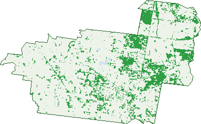
Green: 10 m cells where trees dominate, satellite 2021. Blue: water. The line is the suburb boundary.
| Canopy share, 1 m canopy height map, 2020 | 10.9% |
|---|---|
| Land with trees, 10 m satellite map, 2021 | 17.6% |
Demographics
Unemployment 3.4% · Labour-force participation 57.3%
Population by age in Kyneton
| 0-4 | 365 |
|---|---|
| 5-14 | 901 |
| 15-19 | 377 |
| 20-24 | 292 |
| 25-34 | 660 |
| 35-44 | 910 |
| 45-54 | 1,129 |
| 55-64 | 989 |
| 65-74 | 983 |
| 75-84 | 608 |
| 85+ | 284 |
Dwelling types in Kyneton
| House | 2,534 |
|---|---|
| Townhouse | 257 |
| Apartment | 0 |
| Other | 70 |
Households by weekly income in Kyneton
| <$650 | 494 |
|---|---|
| $650-1,499 | 773 |
| $1,500-2,999 | 818 |
| $3,000+ | 593 |
Top ancestries in Kyneton
| English | 3,249 |
|---|---|
| Australian | 2,887 |
| Irish | 1,263 |
| Scottish | 1,068 |
| Other | 442 |
| Ancestry NS | 415 |
Housing tenure in Kyneton
| Owned | 1,160 |
|---|---|
| Mortgage | 1,030 |
| Rented | 599 |
| Other | 46 |
Cars per household in Kyneton
| 0 | 139 |
|---|---|
| 1 | 931 |
| 2 | 1,126 |
| 3 | 368 |
| 4+ | 255 |
Commute to work in Kyneton
| Car | 1,868 |
|---|---|
| Train | 36 |
| Bus | 0 |
| Tram/ferry | 0 |
| Walked | 128 |
| Bicycle | 18 |
| Home | 885 |
Top countries of birth in Kyneton
| England | 313 |
|---|---|
| New Zealand | 125 |
| Taiwan | 60 |
| Scotland | 43 |
| Philippines | 41 |
| India | 38 |
Languages used at home in Kyneton
| Mandarin | 98 |
|---|---|
| Italian | 32 |
| French | 23 |
| Spanish | 22 |
| German | 19 |
| Greek | 17 |
Birds & Wildlife Nearby
6,459 bird observations recorded near Kyneton — most often seen:
- Australian Magpie (443)
- Little Raven (367)
- Eurasian Blackbird (358)
- Crimson Rosella (343)
- Sulphur-crested Cockatoo (302)
- Long-billed Corella (285)
- Australian Wood Duck (280)
- Red Wattlebird (267)
- Superb Fairy-wren (245)
- Laughing Kookaburra (227)
- Common Starling (226)
- Pacific Black Duck (218)
- Galah (206)
Show all 30 birds recorded near Kyneton
- White-naped Honeyeater (192)
- Yellow-faced Honeyeater (189)
- House Sparrow (186)
- Grey Fantail (185)
- Brown Thornbill (177)
- South-eastern Crimson Rosella (175)
- Common Myna (173)
- White-faced Heron (168)
- Grey Shrike-thrush (163)
- European Goldfinch (157)
- Eastern Red Wattlebird (144)
- Welcome Swallow (139)
- Dusky Moorhen (132)
- Yellow-rumped Thornbill (132)
- Eastern Australian Magpie (129)
- South-eastern Yellow-faced Honeyeater (126)
- Striated Pardalote (125)
Sightings reported by observers, not a survey, so the counts show what people record rather than what lives here. Source: Atlas of Living Australia.
Nearby Suburbs
The closest suburbs to Kyneton:
- Kyneton South (4.6 km)
- Carlsruhe (6.7 km)
- Edgecombe (6.8 km)
- Greenhill (7.3 km)
- Pipers Creek (7.7 km)
- Lauriston (8.1 km)
- Cadello (8.6 km)
- Malmsbury (9 km)
Embed this suburb
Add this free Kyneton stat card to your own site — just copy the code:
Preview:
Cite this page
Quoting these figures? Copy the credit line:
Keep an eye on Kyneton
One email when this data meaningfully changes — new census figures, prices, rankings. No spam, unsubscribe anytime.
Streets
- Acacia Drive (13)
- Amber Close (2)
- Amber Rise (17)
- Andrews Drive (4)
- Angus Way (2)
- Argyle Lane (5)
- Armstrong Court (18)
- Bald Hill Road (38)
- Banksia Crescent (16)
- Bark Lane (2)
- Barton Street (54)
- Batters Lane (23)
- Baynton Road (56)
- Baynton Street (99)
- Beauchamp Street (154)
- Begg Street (44)
- Blackhill Road (39)
- Blackhill School Road (4)
- Blair Drive (38)
- Blair Murphy Close (6)
- Blanche Close (7)
- Blanchfield Drive (16)
- Blossom Court (2)
- Blossom Way (4)
- Bodkin Street (32)
- Bolton Reserve Lane (6)
- Bourke Street (52)
- Bowen Street (51)
- Breakneck Road (3)
- Brocklebank Drive (2)
- Browns Court (9)
- Burton Avenue (38)
- Campaspe Crescent (5)
- Campaspe Drive (29)
- Campaspe Place (4)
- Campbells Court (10)
- Caroline Chisholm Drive (89)
- Carstairs Road (2)
- Castles Crescent (37)
- Chisel Avenue (17)
- Clarke Court (1)
- Clarke Crescent (10)
- Clowes Street (13)
- Cobb And Co Road (7)
- Collins Parade (23)
- Copperhead Road (34)
- Dalgetty Drive (20)
- Deakin Court (11)
- Deep Lead Lane (22)
- Degraves Court (7)
- Degraves Mill Drive (8)
- Dettmanns Lane (10)
- Donnelly Road (13)
- Donnithorne Street (39)
- Donovans Lane (4)
- Duncan Street (6)
- Ebden Street (83)
- Edgecombe Road (62)
- Edgecombe Street (90)
- Elizabeth Avenue (27)
- Epping Street (55)
- Everglow Drive (27)
- Everglow Way (1)
- Faheys Lane (4)
- Fairbairn Place (13)
- Farrier Drive (5)
- Ferguson Street (30)
- Fiddlers Green Road (23)
- Flynns Lane (27)
- Fordes Lane (13)
- Fosters Lane (6)
- Foxes Lane (12)
- Frances Close (13)
- Franklin Place (3)
- Furphy Court (4)
- Geddes Court (8)
- George Street (11)
- Goode Street (13)
- Granite Hill Lane (12)
- Greenway Lane (1)
- Hale Crescent (11)
- Hall Court (21)
- Hallorans Lane (27)
- Harpers Lane (29)
- Harts Lane (31)
- Heathcote-kyneton Road (5)
- High Street (203)
- Hill Crest Court (4)
- Hill Drive (19)
- Hoadleys Lane (3)
- Hogan Court (9)
- Hoyle Court (24)
- Hutton Street (57)
- Irene Way (8)
- Ironmaker Street (3)
- Ironmonger Street (3)
- Jackson Drive (17)
- Jacobs Avenue (31)
- James Court (21)
- Jeffrey Street (15)
- Jennings Street (80)
- Jessie Evelyn Crescent (26)
- Johnson Court (19)
- Kelly Close (10)
- Knight Court (7)
- Kyneton Road (1)
- Kyneton Springhill Road (18)
- Kyneton-metcalfe Road (75)
- Kyneton-springhill Road (17)
- Langley Street (12)
- Latrobe Street (22)
- Lauriston Reservoir Road (46)
- Lauriston Road (21)
- Lauriston Street (61)
- Lauriston-springhill Road (5)
- Lavender Street (18)
- Lavenders Lane (8)
- Leared Drive (37)
- Leete Street (9)
- Lennox Street (2)
- Macdonald Court (8)
- Mair Street (40)
- Market Street (81)
- Martin Place (21)
- Maxwell Street (39)
- Mayfair Way (8)
- Mcphersons Lane (3)
- Melville Drive (8)
- Menzies Close (18)
- Mill Street (20)
- Mitchell Street (111)
- Mollison Place (7)
- Mollison Street (193)
- Mount St Marys Lane (2)
- Mt St Marys Lane (3)
- Mulfaheys Road (11)
- Murphys Road (19)
- Natures Lane (8)
- New Street (14)
- North Street (9)
- Northumberland Road (24)
- Oak Ridge Court (13)
- Oasis Avenue (9)
- Old Station Road (3)
- Opal Court (15)
- Orr Street (29)
- Palmer Place (39)
- Parkes Drive (6)
- Parsell Road (1)
- Pastoria Road (7)
- Patterson Drive (39)
- Pearl Court (28)
- Penzance Court (6)
- Piper Street (169)
- Pipers Creek Road (47)
- Pleasant Hill Road (2)
- Pohlman Street (44)
- Postmaster Way (31)
- Powlett Street (68)
- Quinn Crescent (4)
- Rawson Place (10)
- Redesdale Road (49)
- Redhill Road (8)
- Regent Place (20)
- Rennick Avenue (9)
- Ridgeway Crescent (3)
- Rigby Drive (9)
- Ripplebrook Way (19)
- Ritchies Road (8)
- Riverview Drive (4)
- Riverwalk Boulevard (1)
- Rogers Drive (14)
- Rosa Court (25)
- Ross Street (6)
- Saleyards Road (46)
- Sanctuary Drive (14)
- Sebastopol Road (21)
- Sheffield Place (2)
- Shepherds Hill Road (1)
- Sibbleys Lane (4)
- Silver Smith Drive (14)
- Simpson Street (68)
- Smith Court (7)
- South Lane (17)
- South Sebastopol Road (3)
- St Agnes Place (6)
- Stevensons Rise (18)
- Stonemason Boulevard (16)
- Strawhorn Court (9)
- Sturt Street (34)
- Tattersall Drive (31)
- Taylors Court (5)
- Tinsmith Drive (18)
- Tonks Court (15)
- Tower Street (10)
- Trentham Road (7)
- Trio Place (10)
- Trio Road (26)
- Verekers Lane (31)
- Victoria Street (46)
- Village Green Drive (29)
- Ward Street (14)
- Wards Lane (6)
- Warren Street (85)
- Waterway Close (12)
- Wattle Way (2)
- Websters Road (3)
- Wedge Court (11)
- Wedge Street (83)
- Wells Court (8)
- Welsh Street (32)
- Westview Court (12)
- Wheatley Street (48)
- Wheel Wright Lane (7)
- Wilson Way (4)
- Windridge Way (15)
- Wittingslow Lane (3)
- Wolfe Road (3)
- Yaldwyn Street E (40)
- Yaldwyn Street W (60)
- Youngs Road (6)