Keysborough VIC 3173
13,361 addresses · 531 streets
Isaacs Electorate › Greater Dandenong LGA › Keysborough · 27 km from Melbourne
📦 Thinking of moving here? Read the Keysborough moving guide

Living Here
A growing outer-south-eastern Melbourne suburb of newer family estates, Keysborough is diverse and family-focused. Households average 3.2 people and the median age is 36. Median household income is $1,991 a week, with rent around $421.
Keysborough is a suburb of Victoria, home to about 30,018 people, with a median age of 36. The typical household earns around $1,991 a week, with median rent near $421 a week. Most homes are houses. About 80% of households own their home and 19% rent. Most workers drive to work. Common community backgrounds include Chinese, Vietnamese, English. On the ABS socio-economic scale it sits in decile 6 of 10 nationally — a mid-range area. The median house sells for about $931,000.
Over time — Census 2001 → 2021
Dashed line: district figures for the Keysborough statistical area (SA2), the smallest area the ABS published before 2011. Solid line: Keysborough itself.
Getting Around & Local Services
6 supermarkets
10 Catholic churches
3 doctors & medical clinics
4 physiotherapists
3 post offices
1 bakery
2 hairdressers
1 beauty salon
3 places to stay
Getting around. Train station: Yarraman, 2.9 km north-east · Bus interchange: Monash University, 9.8 km north · Airport: Moorabbin Airport, 6.4 km west.
Sport & Recreation
9 facilities recorded in Keysborough.
- Frederick Watcher Reserve Australian Rules Football, Cricket, Tennis (Outdoor)
- Gaelic Park Gaelic Football, Soccer
- Keysborough Community Park Cricket
- Keysborough Golf Course Golf
- Keysborough Reserve Australian Rules Football, Cricket, Lawn Bowls, Netball
- Maurie Jarvis Woodland Australian Rules Football, Cricket
- Parkmore Soccer Club Soccer
- Springers Leisure Centre Badminton, Basketball, Carpet Bowls, Netball (Indoor), Soccer (Indoor Soccer / Futsal), Volleyball
- The Grenda Aquatic Centre (Haileybury College Pool) Swimming
Socio-economic Standing
Deciles from 1 (lowest) to 10 (highest), against all Australian suburbs. The overall figure weighs advantage and disadvantage together; economic resources counts income and housing, and education & jobs counts qualifications and occupation. They often differ. Source: ABS SEIFA 2021.
Median Sale Prices
Median of recorded sales in the period, not a valuation. Source: Victorian Property Sales Report, Land Use Victoria.
Tree cover
🌳 Tree canopy: 7.4% share of land under canopy · satellite map, 2020
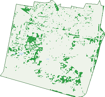
Green: 10 m cells where trees dominate, satellite 2021. Blue: water. The line is the suburb boundary.
| Canopy share, 1 m canopy height map, 2020 | 7.4% |
|---|---|
| Land with trees, 10 m satellite map, 2021 | 9.8% |
Demographics
Unemployment 5.4% · Labour-force participation 63.1%
Population by age in Keysborough
| 0-4 | 1,868 |
|---|---|
| 5-14 | 4,030 |
| 15-19 | 1,886 |
| 20-24 | 1,975 |
| 25-34 | 4,260 |
| 35-44 | 4,723 |
| 45-54 | 3,843 |
| 55-64 | 3,188 |
| 65-74 | 2,507 |
| 75-84 | 1,276 |
| 85+ | 456 |
Dwelling types in Keysborough
| House | 8,144 |
|---|---|
| Townhouse | 858 |
| Apartment | 97 |
| Other | 0 |
Households by weekly income in Keysborough
| <$650 | 1,073 |
|---|---|
| $650-1,499 | 2,149 |
| $1,500-2,999 | 3,086 |
| $3,000+ | 2,271 |
Top ancestries in Keysborough
| Other | 9,546 |
|---|---|
| Chinese | 5,704 |
| Vietnamese | 3,477 |
| English | 3,407 |
| Australian | 3,384 |
| Indian | 2,195 |
Housing tenure in Keysborough
| Owned | 2,893 |
|---|---|
| Mortgage | 4,252 |
| Rented | 1,701 |
| Other | 126 |
Cars per household in Keysborough
| 0 | 338 |
|---|---|
| 1 | 2,235 |
| 2 | 4,035 |
| 3 | 1,538 |
| 4+ | 860 |
Commute to work in Keysborough
| Car | 9,593 |
|---|---|
| Train | 155 |
| Bus | 88 |
| Tram/ferry | 6 |
| Walked | 73 |
| Bicycle | 29 |
| Home | 2,788 |
Top countries of birth in Keysborough
| Vietnam | 2,575 |
|---|---|
| Cambodia | 2,556 |
| India | 1,981 |
| China | 1,544 |
| Sri Lanka | 1,134 |
| Philippines | 478 |
Languages used at home in Keysborough
| Vietnamese | 3,449 |
|---|---|
| Khmer | 2,919 |
| Mandarin | 2,031 |
| Cantonese | 1,140 |
| Sinhalese | 667 |
| Turkish | 665 |
Birds & Wildlife Nearby
189,469 bird observations recorded near Keysborough — most often seen:
- Pacific Black Duck (8,996)
- Little Raven (8,809)
- Common Myna (8,758)
- Chestnut Teal (8,413)
- Eurasian Coot (8,211)
- Noisy Miner (8,003)
- Australasian Purple Swamphen (7,945)
- Magpie-lark (7,532)
- Common Starling (7,266)
- Australian Magpie (7,161)
- Rainbow Lorikeet (7,096)
- Black Swan (6,517)
- Dusky Moorhen (6,432)
Show all 30 birds recorded near Keysborough
- Grey Teal (6,065)
- Little Pied Cormorant (6,051)
- Spotted Turtle-dove (6,018)
- Welcome Swallow (5,939)
- Superb Fairy-wren (5,938)
- Eurasian Blackbird (5,710)
- Red Wattlebird (5,625)
- White-faced Heron (5,393)
- Sulphur-crested Cockatoo (5,003)
- Grey Butcherbird (4,964)
- Australian Wood Duck (4,898)
- Silver Gull (4,685)
- Eastern Rosella (4,496)
- Australian Pelican (4,490)
- Brown Thornbill (4,466)
- Little Black Cormorant (4,440)
- Australian White Ibis (4,149)
Sightings reported by observers, not a survey, so the counts show what people record rather than what lives here. Source: Atlas of Living Australia.
Nearby Suburbs
The closest suburbs to Keysborough:
- Springvale South (3.3 km)
- Noble Park (3.3 km)
- Waterways (3.6 km)
- Dandenong (4 km)
- Dingley Village (4.1 km)
- Braeside (5 km)
- Dandenong South (5.1 km)
- Aspendale Gardens (5.1 km)
Embed this suburb
Add this free Keysborough stat card to your own site — just copy the code:
Preview:
Cite this page
Quoting these figures? Copy the credit line:
Keep an eye on Keysborough
One email when this data meaningfully changes — new census figures, prices, rankings. No spam, unsubscribe anytime.
Streets
- Abercrombie Avenue (41)
- Accra Street (17)
- Adele Street (29)
- Adriatic Way (10)
- Aegean Avenue (6)
- Aegean Court (11)
- Agostino Court (10)
- Akita Court (9)
- Alana Court (14)
- Albert Park Way (24)
- Alderberry Road (5)
- Allawah Close (18)
- Allington Avenue (6)
- Amanda Court (11)
- Amy Mews (6)
- Annabelle Boulevard (21)
- Annafee Avenue (29)
- Apollo Court (11)
- Appleton Avenue (14)
- Arafura Lane (7)
- Arctic Court (21)
- Ascot Place (31)
- Ashland Court (6)
- Ashleigh Street (10)
- Aspect Drive (36)
- Aspire Place (23)
- Atlantic Drive (99)
- Aubin Court (7)
- Auburn Drive (20)
- Azure Crescent (19)
- Badminton Place (3)
- Balgowlah Avenue (50)
- Baltic Way (10)
- Barlow Street (4)
- Barncroft Crescent (18)
- Baroda Court (7)
- Barrington Close (7)
- Bass Court (44)
- Bavadia Place (17)
- Beach Court (13)
- Beau Vorno Avenue (46)
- Beaufort Street (22)
- Beddington Street (44)
- Bellarine Court (22)
- Belsize Way (8)
- Bend Road (44)
- Benjamin Court (11)
- Berala Court (5)
- Bergen Street (42)
- Berry Court (7)
- Beverley Place (12)
- Bilbungra Drive (9)
- Blanchard Avenue (20)
- Blodorn Court (4)
- Bloomfield Road (108)
- Bluebell Way (18)
- Boileau Street (66)
- Bonnie Crescent (10)
- Boronia Court (4)
- Botanica Way (9)
- Bowman Lane (5)
- Bracknell Street (41)
- Breanne Place (46)
- Bremer Circuit (14)
- Brett Drive (29)
- Brewer Court (4)
- Bridge Road (113)
- Brigalo Court (14)
- Broadleaf Court (28)
- Brott Court (18)
- Bundeena Avenue (70)
- Burnham Crescent (58)
- Burraneer Drive (30)
- Cabarita Court (8)
- Cabinda Drive (69)
- Cafardi Boulevard (22)
- Caledonian Court (11)
- Calibre Retreat (107)
- Callibris Court (7)
- Callistemon Avenue (39)
- Cambria Road (93)
- Cameron Place (9)
- Carey Court (6)
- Carramar Court (4)
- Carribean Drive (13)
- Carson Avenue (5)
- Cascade Place (15)
- Cassia Court (5)
- Cassowary Lane (6)
- Cayley Court (9)
- Cedar Court (9)
- Celtic Court (2)
- Centenary Court (13)
- Centre Kirkham Road (1)
- Chandler Road (230)
- Chapel Road (255)
- Cheltenham Road (631)
- Cherry Court (10)
- Cherryfield Drive (16)
- Chesney Street (13)
- Cheviot Road (41)
- Chi Avenue (86)
- Chris Court (10)
- Church Road (164)
- Cindy Close (14)
- Clais Street (10)
- Clara Court (9)
- Claremont Crescent (19)
- Clarence Avenue (20)
- Clarendon Drive (167)
- Clinton Drive (14)
- Cobain Street (7)
- Cochrane Avenue (46)
- Colchester Court (20)
- College Crescent (32)
- Colville Crescent (21)
- Condon Court (11)
- Coolibah Place (29)
- Coral Court (2)
- Coram Court (4)
- Cornwall Avenue (23)
- Correa Walk (5)
- Corrigan Road (182)
- Corrigans Run (16)
- Cottongum Avenue (25)
- Cromwell Court (8)
- Cunningham Parade (11)
- Currawong Street (22)
- Cutler Avenue (22)
- Daffodil Drive (21)
- Dahlia Crescent (37)
- Daisy Close (6)
- Darlington Street (14)
- Darren Road (105)
- Daylily Drive (16)
- Deanswood Close (17)
- Denbigh Court (8)
- Denmark Road (27)
- Dennis Court (7)
- Desmond Street (16)
- Devonshire Drive (38)
- Dewberry Drive (19)
- Domain Drive (23)
- Dominique Place (12)
- Donnici Drive (28)
- Dorset Court (5)
- Dryandra Crescent (18)
- Dumfries Road (20)
- East Court (11)
- Eastbury Street (16)
- Edgecomb Street (26)
- Edgewater Drive (14)
- Eildon Drive (39)
- Eldo Street (30)
- Elise Court (15)
- Ellsa Close (12)
- Ellsworth Drive (17)
- Elmbank Drive (54)
- Elmsford Court (29)
- Elmswood Boulevard (71)
- Elysian Place (9)
- Emily Promenade (27)
- Emmaline Crescent (30)
- Emmerson Street (13)
- Ennismore Drive (17)
- Epacris Place (3)
- Erin Place (12)
- Evergreen Boulevard (15)
- Fabian Court (17)
- Fairborne Way (3)
- Fairlight Avenue (12)
- Fairthorne Street (15)
- Fairview Close (22)
- Faoro Court (10)
- Farm Road (6)
- Fenland Place (10)
- Fenton Court (59)
- Fernhurst Close (4)
- Fernleaf Avenue (21)
- Ferntree Way (3)
- Festival Crescent (73)
- Filer Court (15)
- Finchaven Avenue (30)
- Findlay Crescent (2)
- Finisterre Drive (17)
- Fiona Court (8)
- Fiveways Boulevarde (105)
- Fleckney Court (8)
- Floss Court (16)
- Frenchman Way (17)
- Fulham Court (4)
- Futura Road (58)
- Garden Court (20)
- Gemini Court (10)
- Geoffrey Court (15)
- Georgia Place (15)
- Gianluca Avenue (11)
- Gianni Court (9)
- Gilbert Court (6)
- Glenfern Street (27)
- Glenthorne Drive (46)
- Goldhurst Street (12)
- Goldstone Court (6)
- Graham Court (9)
- Graham-michele Place (47)
- Grandia Crescent (38)
- Granton Close (6)
- Grasslands Loop (27)
- Grayling Crescent (23)
- Greenleaf Court (28)
- Greens Road (17)
- Greenside Crescent (24)
- Greenview Terrace (12)
- Gregory Court (17)
- Grevillea Street (15)
- Grosvenor Street (10)
- Gymea Court (16)
- Hagan Place (8)
- Haileybury Court (12)
- Hakea Place (19)
- Haldane Street (26)
- Hales Court (17)
- Hanbury Court (14)
- Hardy Loop (52)
- Harlequin Drive (14)
- Harlow Court (7)
- Harrington Street (9)
- Hartwell Street (31)
- Harvard Grove (12)
- Hatfield Court (12)
- Havenstone Drive (44)
- Hawkins Court (23)
- Hayman Close (6)
- Hedgeley Road (45)
- Henderson Road (101)
- Henty Court (5)
- Hibiscus Way (5)
- Hidden Grove Boulevard (30)
- Highbury Grove (16)
- Homeleigh Road (40)
- Howland Place (14)
- Hudson Court (16)
- Hutton Road (26)
- Illukey Court (11)
- Indian Drive (157)
- Ionian Way (1)
- Iris Court (9)
- Iron Bark Close (3)
- Isaac Road (39)
- Isabelle Avenue (15)
- Island Road (1)
- Jacaranda Lane (20)
- Jakes Road (5)
- Jalta Court (6)
- Jarrod Court (5)
- Jean Court (8)
- Jon Place (16)
- June Court (18)
- Juneberry Drive (38)
- Juniper Court (4)
- Kano Court (10)
- Karri Lane (5)
- Katoomba Court (7)
- Kawarra Drive (10)
- Keith Court (16)
- Kempson Court (39)
- Kendra Place (18)
- Kent Court (10)
- Keylana Drive (120)
- Keys Road (44)
- Keysborough Avenue (25)
- Kilbride Street (17)
- Kilburn Court (7)
- Kingcote Drive (9)
- Kingsclere Avenue (144)
- Kinnoul Avenue (30)
- Kirkham Road W (109)
- Kirribilli Avenue (56)
- Koala Court (6)
- Kogarah Court (20)
- Kotiko Road (26)
- Labassa Court (11)
- Lachlan Place (7)
- Lagrange Mews (21)
- Laidlaw Court (14)
- Lake Edge Drive (4)
- Lake View Boulevard (121)
- Lambeth Court (5)
- Lancaster Court (11)
- Latrobe Avenue (14)
- Leanne Crescent (25)
- Leeson Place (4)
- Len George Drive (22)
- Lenah Crescent (30)
- Lenton Road (4)
- Lillypilly Circuit (55)
- Lincoln Court (1)
- Linden Drive (34)
- Liverpool Drive (92)
- Livingstone Court (8)