Kew VIC 3101
14,265 addresses · 268 streets
Kooyong Electorate › Boroondara LGA › Kew · 7 km from Melbourne
📦 Thinking of moving here? Read the Kew moving guide

Living Here
An affluent inner-eastern Melbourne suburb known for its period mansions and schools, Kew is leafy and established. Households average 2.5 people and the median age is 41. Median household income is high at $2,497 a week, with rent around $476.
Kew is a suburb of Victoria, home to about 24,499 people, with a median age of 41. The typical household earns around $2,497 a week, with median rent near $476 a week. Most homes are houses. About 69% of households own their home and 29% rent. Most workers work from home. Common community backgrounds include English, Australian, Chinese. On the ABS socio-economic scale it sits in decile 10 of 10 nationally — a relatively advantaged area. The median house sells for about $2,805,000.
Over time — Census 2001 → 2021
Dashed line: district figures for the Kew statistical area (SA2), the smallest area the ABS published before 2011. Solid line: Kew itself.
Getting Around & Local Services
1 beach
Getting around. Train station: Glenferrie, 1.8 km south · Tram stop: Stop 35: Charles Street, 100 m west · Railway halt: Box Hill, 7 km east · Bus interchange: Bulleen Park and Ride, 5 km north-east · Ferry wharf: Herring Island Pier, 4.3 km south-west · Airport: Essendon Fields Airport, 15 km north-west.
Sport & Recreation
5 facilities recorded in Kew.
- Kew Boulevard Cycling
- Kew Heights Sports Club Lawn Bowls, Tennis (Outdoor)
- Kew Recreation Centre Aerobics, Fitness / Gymnasium Workouts, Karate, Swimming
- Reservoir Reserve Cricket
- Victoria Park Australian Rules Football, Cricket, Tennis (Outdoor)
Socio-economic Standing
Deciles from 1 (lowest) to 10 (highest), against all Australian suburbs. The overall figure weighs advantage and disadvantage together; economic resources counts income and housing, and education & jobs counts qualifications and occupation. They often differ. Source: ABS SEIFA 2021.
Median Sale Prices
Median of recorded sales in the period, not a valuation. Source: Victorian Property Sales Report, Land Use Victoria.
Tree cover
🌳 Tree canopy: 18.3% share of land under canopy · satellite map, 2020
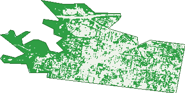
Green: 10 m cells where trees dominate, satellite 2021. Blue: water. The line is the suburb boundary.
| Canopy share, 1 m canopy height map, 2020 | 18.3% |
|---|---|
| Land with trees, 10 m satellite map, 2021 | 50.3% |
Demographics
Unemployment 3.9% · Labour-force participation 63.6%
Population by age in Kew
| 0-4 | 947 |
|---|---|
| 5-14 | 2,761 |
| 15-19 | 1,705 |
| 20-24 | 1,758 |
| 25-34 | 3,169 |
| 35-44 | 2,829 |
| 45-54 | 3,436 |
| 55-64 | 3,154 |
| 65-74 | 2,468 |
| 75-84 | 1,491 |
| 85+ | 786 |
Dwelling types in Kew
| House | 4,577 |
|---|---|
| Townhouse | 2,137 |
| Apartment | 2,324 |
| Other | 22 |
Households by weekly income in Kew
| <$650 | 972 |
|---|---|
| $650-1,499 | 1,565 |
| $1,500-2,999 | 2,243 |
| $3,000+ | 3,729 |
Top ancestries in Kew
| English | 7,127 |
|---|---|
| Australian | 5,837 |
| Chinese | 3,974 |
| Irish | 3,237 |
| Other | 2,845 |
| Scottish | 2,414 |
Housing tenure in Kew
| Owned | 3,583 |
|---|---|
| Mortgage | 2,628 |
| Rented | 2,590 |
| Other | 165 |
Cars per household in Kew
| 0 | 553 |
|---|---|
| 1 | 3,667 |
| 2 | 3,398 |
| 3 | 905 |
| 4+ | 444 |
Commute to work in Kew
| Car | 4,852 |
|---|---|
| Train | 64 |
| Bus | 93 |
| Tram/ferry | 232 |
| Walked | 376 |
| Bicycle | 171 |
| Home | 5,096 |
Top countries of birth in Kew
| China | 1,622 |
|---|---|
| England | 708 |
| Malaysia | 539 |
| India | 448 |
| New Zealand | 336 |
| Hong Kong | 317 |
Languages used at home in Kew
| Mandarin | 2,115 |
|---|---|
| Greek | 723 |
| Cantonese | 696 |
| Italian | 411 |
| Vietnamese | 353 |
| Spanish | 166 |
Birds & Wildlife Nearby
195,160 bird observations recorded near Kew — most often seen:
- Rainbow Lorikeet (14,148)
- Common Myna (13,639)
- Noisy Miner (12,150)
- Little Raven (10,308)
- Magpie-lark (10,233)
- Red Wattlebird (9,726)
- Australian Magpie (9,461)
- Rock Dove (8,794)
- Pacific Black Duck (7,782)
- Spotted Turtle-dove (7,636)
- Dusky Moorhen (6,877)
- Eurasian Blackbird (6,224)
- Pied Currawong (6,165)
Show all 30 birds recorded near Kew
- Grey Butcherbird (5,409)
- Red-rumped Parrot (5,040)
- Welcome Swallow (5,028)
- Common Starling (5,012)
- Silver Gull (4,982)
- Australian Wood Duck (4,959)
- Brown Thornbill (4,658)
- Superb Fairy-wren (4,283)
- Southern Victoria Australian Magpie (4,271)
- Willie Wagtail (4,056)
- Eastern Rosella (3,787)
- Chestnut Teal (3,735)
- White-browed Scrubwren (3,689)
- White-plumed Honeyeater (3,574)
- Grey Fantail (3,327)
- Laughing Kookaburra (3,194)
- Sulphur-crested Cockatoo (3,013)
Sightings reported by observers, not a survey, so the counts show what people record rather than what lives here. Source: Atlas of Living Australia.
Nearby Suburbs
The closest suburbs to Kew:
- Kew East (1.8 km)
- Hawthorn (2.1 km)
- Deepdene (2.6 km)
- Alphington (2.8 km)
- Hawthorn East (3 km)
- Abbotsford (3.1 km)
- Burnley (3.5 km)
- Richmond (3.5 km)
Embed this suburb
Add this free Kew stat card to your own site — just copy the code:
Preview:
Cite this page
Quoting these figures? Copy the credit line:
Keep an eye on Kew
One email when this data meaningfully changes — new census figures, prices, rankings. No spam, unsubscribe anytime.
Streets
- Abeckett Street (19)
- Adeney Avenue (94)
- Alfred Street (97)
- Annadale Street (10)
- Arbour Drive (12)
- Argyle Road (95)
- Asquith Street (42)
- Athenaeum Place (1)
- Atkins Street (45)
- Balmoral Avenue (14)
- Banool Avenue (24)
- Barenya Court (50)
- Barkers Road (371)
- Barnard Grove (67)
- Barrington Avenue (50)
- Barry Street (32)
- Beatrice Street (7)
- Belford Road (1)
- Belmont Avenue (57)
- Belvedere (10)
- Berkeley Court (10)
- Birrell Court (12)
- Blythswood Court (14)
- Boathouse Road (1)
- Botanic Drive (13)
- Bowen Street (33)
- Bowyer Avenue (10)
- Bradford Avenue (22)
- Bramley Court (8)
- Brazier Grove (8)
- Bright Street (7)
- Brougham Street (277)
- Burke Road (253)
- Burne Court (7)
- Byron Street (26)
- Cameron Court (3)
- Campbell Street (87)
- Canopy Avenue (4)
- Carnsworth Avenue (12)
- Carson Street (71)
- Cecil Street (130)
- Chandler Highway (7)
- Charles Street (76)
- Childers Street (87)
- Churchill Street (42)
- Civic Drive (1)
- Clevedon Court (7)
- Cobden Street (141)
- Coleridge Street (11)
- College Parade (49)
- College Place (2)
- Collins Street (19)
- Coombs Avenue (5)
- Cotham Road (726)
- Cradley Avenue (14)
- Cremin Close (14)
- Cypress Way (28)
- Daniell Place (16)
- Daracombe Avenue (6)
- Davis Street (96)
- Dean Street (51)
- Denmark Street (140)
- Derby Street (249)
- Derrick Street (12)
- Disraeli Street (178)
- Doona Avenue (10)
- Downton Grove (12)
- Duke Street (63)
- Dunlop Avenue (37)
- Eamon Court (10)
- Earl Street (247)
- Edgecombe Street (41)
- Edgevale Road (172)
- Edward Street (40)
- Eglinton Street (187)
- Ellesmore Court (12)
- Elphinstone Court (5)
- English Place (9)
- Ermington Place (18)
- Evans Road (23)
- Fellows Street (98)
- Fenton Avenue (10)
- Fenton Way (7)
- Fenwick Street (83)
- Ferguson Street (8)
- Fernhurst Grove (147)
- Findon Crescent (26)
- Finhaven Court (11)
- First Avenue (69)
- Fitzwilliam Street (71)
- Florence Avenue (36)
- Foley Street (90)
- Franks Grove (12)
- Garden Terrace (2)
- Gellibrand Street (67)
- Gladstone Street (172)
- Glendene Avenue (16)
- Glenferrie Road (143)
- Goldthorns Avenue (26)
- Gordon Avenue (19)
- Grace Court (26)
- Grandview Terrace (71)
- Grange Road (41)
- Greer Place (3)
- Griffiths Grove (1)
- Guest Close (7)
- Halfey Lane (3)
- Hansen Street (17)
- Harp Road (176)
- Hartington Street (117)
- Heather Grove (31)
- Henry Street (18)
- Henty Court (4)
- High Street (493)
- High Street S (376)
- Highbury Grove (52)
- Highfield Grove (20)
- Hillcrest Avenue (40)
- Hodgson Street (18)
- Holly Drive (10)
- Holly Lane (10)
- Holroyd Street (24)
- Hope Court (27)
- Howard Street (48)
- Hume Street (12)
- Hummingbird Lane (3)
- Hunter Street (19)
- Hutchinson Drive (30)
- Hyton Crescent (26)
- James Avenue (47)
- John Street (23)
- Kellett Grove (47)
- Kent Street (68)
- Kevin Grove (6)
- Lady Brasseys Drive (4)
- Lady Lochs Drive (9)
- Lalla Court (6)
- Lalla Street (11)
- Laver Street (35)
- Linnaker Place (16)
- Loch Street (27)
- Locksley Avenue (9)
- Lofts Avenue (12)
- Lower Drive (29)
- Lower Drive N (13)
- Loxton Street (16)
- Lytton Street (21)
- Macartney Avenue (47)
- Mackie Court (14)
- Madden Grove (24)
- Main Drive (84)
- Maitland Avenue (42)
- Majella Court (10)
- Malin Street (51)
- Malmsbury Street (111)
- Marie Dalley Drive (1)
- Marshall Avenue (77)
- Mary Street (104)
- Mawson Street (8)
- Maxwell Street (10)
- May Street (41)
- Mcevoy Street (21)
- Merrion Grove (9)
- Merrion Place (14)
- Milfay Avenue (19)
- Miller Grove (41)
- Molesworth Street (88)
- Mont Victor Road (17)
- Monterey Close (15)
- Moonbria Avenue (8)
- Moreton Close (8)
- Mortimer Street (9)
- Mount Street (48)
- Mountain Grove (46)
- Murphy Street (7)
- Myrtle Avenue (13)
- New Street (10)
- Newman-morris Place (7)
- Nolan Avenue (2)
- Normanby Road (109)
- Oak Close (5)
- Obrien Court (10)
- Orford Avenue (8)
- Oshaughnessy Street (51)
- Owen Street (8)
- Pakington Street (321)
- Park Avenue (54)
- Park Crescent (61)
- Park Lane (14)
- Parkhill Drive (14)
- Parkhill Road (121)
- Peel Street (297)
- Perry Court (7)
- Pleasant Avenue (17)
- Princess Street (585)
- Queen Street (23)
- Raheen Drive (21)
- Raven Street (21)
- Redmond Street (27)
- Reeves Court (7)
- Regency Grove (7)
- Ridgeway Avenue (77)
- Rimington Avenue (20)
- River Retreat (10)
- Rochester Street (17)
- Rockingham Close (19)
- Rockingham Street (44)
- Ross Street (30)
- Rossfield Avenue (39)
- Rowland Street (59)
- Royston Court (5)
- Sackville Street (127)
- Scott Street (31)
- Second Avenue (25)
- Segtoune Street (27)
- Selbourne Road (17)
- Simpson Street (22)
- Sir William Street (13)
- St Anthonys Place (19)
- St Johns Parade (19)
- Stainer Street (6)
- Stanley Street (10)
- Stansell Street (22)
- Stawell Street (64)
- Stevens Close (17)
- Stevenson Street (165)
- Stirling Street (40)
- Stoke Avenue (27)
- Stratford Avenue (9)
- Studley Avenue (56)
- Studley Park Road (308)
- Swinton Avenue (48)
- Sylvan Court (6)
- Tara Avenue (23)
- Tennyson Street (74)
- The Pines (6)
- Thomas Street (34)
- Thornton Street (14)
- Tregarron Avenue (10)
- Union Street (26)
- Uvadale Grove (40)
- Valentine Avenue (27)
- Vaughan Crescent (52)
- Victor Avenue (21)
- View Point (12)
- Vista Avenue (14)
- Walmer Street (33)
- Walpole Street (440)
- Walsh Street (10)
- Walton Street (11)
- Waverley Avenue (8)
- Weir Street (21)
- Wellington Street (194)
- White Lodge Court (9)
- Wills Street (78)
- Willsmere Road (173)
- Wiltshire Drive (259)
- Wimba Avenue (87)
- Windsor Street (13)
- Winton Street (10)
- Wishart Street (25)
- Woodford Avenue (5)
- Wrixon Street (16)
- Yarra Boulevard (6)
- Yarra Street (20)
- Yarravale Road (24)
- Young Street (57)
- Younger Court (17)