Kerang VIC 3579
2,608 addresses · 127 streets
Mallee Electorate › Gannawarra LGA › Kerang · 249 km from Melbourne
📦 Thinking of moving here? Read the Kerang moving guide

Living Here
Kerang is a suburb of Victoria, home to about 3,960 people, with a median age of 51. The typical household earns around $1,006 a week, with median rent near $200 a week. Most homes are houses. About 75% of households own their home and 23% rent. Most workers drive to work. Common community backgrounds include English, Australian, Scottish. On the ABS socio-economic scale it sits in decile 2 of 10 nationally — a more disadvantaged area. The median house sells for about $310,000.
Over time — Census 2001 → 2021
Dashed line: district figures for the Kerang statistical area (SA2), the smallest area the ABS published before 2011. Solid line: Kerang itself.
Getting Around & Local Services
3 cafés & restaurants
2 supermarkets
1 Catholic church
1 pharmacy
1 medical clinic
1 dentist
1 physiotherapist
1 optometrist
1 hospital
1 library
1 post office
4 service stations
3 gyms & sports centres
1 golf club
1 bakery
1 butcher
1 hardware store
1 mechanic
Getting around. Train station: Kerang, 200 m south-east · Airport: Kerang Airport, 2.7 km south-east.
Sport & Recreation
10 facilities recorded in Kerang.
- Alexandra Park Croquet, Equestrian
- Atkinson Park Modern Pentathlon, Skating
- Kerang Bowling Club Lawn Bowls
- Kerang Golf and Bowls Club Golf, Lawn Bowls
- Kerang Lawn Tennis Club Tennis (Outdoor)
- Kerang Pistol Club Shooting Sports
- Kerang Swimming Pool Swimming
- Patchell Plaza Warm Water Pool Swimming
- Riverside Park Sports Reserve Australian Rules Football, Cricket, Netball
- St Patricks Tennis Club Tennis (Outdoor)
Socio-economic Standing
Deciles from 1 (lowest) to 10 (highest), against all Australian suburbs. The overall figure weighs advantage and disadvantage together; economic resources counts income and housing, and education & jobs counts qualifications and occupation. They often differ. Source: ABS SEIFA 2021.
Median Sale Prices
Median of recorded sales in the period, not a valuation. Source: Victorian Property Sales Report, Land Use Victoria.
Tree cover
🌳 Tree canopy: 3.3% share of land under canopy · satellite map, 2020
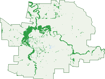
Green: 10 m cells where trees dominate, satellite 2021. Blue: water. The line is the suburb boundary.
| Canopy share, 1 m canopy height map, 2020 | 3.3% |
|---|---|
| Land with trees, 10 m satellite map, 2021 | 7.8% |
Demographics
Unemployment 5% · Labour-force participation 47%
Population by age in Kerang
| 0-4 | 201 |
|---|---|
| 5-14 | 454 |
| 15-19 | 179 |
| 20-24 | 174 |
| 25-34 | 346 |
| 35-44 | 381 |
| 45-54 | 434 |
| 55-64 | 580 |
| 65-74 | 612 |
| 75-84 | 401 |
| 85+ | 215 |
Dwelling types in Kerang
| House | 1,483 |
|---|---|
| Townhouse | 135 |
| Apartment | 0 |
| Other | 38 |
Households by weekly income in Kerang
| <$650 | 450 |
|---|---|
| $650-1,499 | 586 |
| $1,500-2,999 | 369 |
| $3,000+ | 117 |
Top ancestries in Kerang
| English | 1,802 |
|---|---|
| Australian | 1,714 |
| Scottish | 468 |
| Irish | 423 |
| Ancestry NS | 284 |
| German | 171 |
Housing tenure in Kerang
| Owned | 770 |
|---|---|
| Mortgage | 426 |
| Rented | 375 |
| Other | 31 |
Cars per household in Kerang
| 0 | 117 |
|---|---|
| 1 | 628 |
| 2 | 543 |
| 3 | 205 |
| 4+ | 115 |
Commute to work in Kerang
| Car | 1,060 |
|---|---|
| Train | 0 |
| Bus | 3 |
| Tram/ferry | 0 |
| Walked | 90 |
| Bicycle | 9 |
| Home | 114 |
Top countries of birth in Kerang
| England | 63 |
|---|---|
| Philippines | 25 |
| South Africa | 21 |
| India | 14 |
| New Zealand | 14 |
| Netherlands | 7 |
Languages used at home in Kerang
| Filipino | 11 |
|---|---|
| Greek | 9 |
| Punjabi | 8 |
| Thai | 8 |
| Tagalog | 7 |
| Serbian | 6 |
Birds & Wildlife Nearby
11,072 bird observations recorded near Kerang — most often seen:
- Grey Teal (566)
- Pacific Black Duck (503)
- Australian White Ibis (497)
- Crested Pigeon (487)
- Magpie-lark (481)
- Common Starling (463)
- House Sparrow (463)
- Australian Shelduck (458)
- Red-rumped Parrot (443)
- Superb Fairy-wren (428)
- Noisy Miner (409)
- Welcome Swallow (402)
- Whistling Kite (402)
Show all 30 birds recorded near Kerang
- Straw-necked Ibis (393)
- Australian Magpie (377)
- Masked Lapwing (363)
- White-plumed Honeyeater (348)
- Galah (341)
- Willie Wagtail (310)
- Eastern Rosella (306)
- Black Swan (305)
- White-faced Heron (302)
- Australian Pelican (299)
- Silver Gull (297)
- Black Kite (266)
- Eurasian Coot (256)
- Little Raven (246)
- Australasian Purple Swamphen (223)
- Royal Spoonbill (223)
- Brown Treecreeper (215)
Sightings reported by observers, not a survey, so the counts show what people record rather than what lives here. Source: Atlas of Living Australia.
Nearby Suburbs
The closest suburbs to Kerang:
- Wandella (7.3 km)
- Reedy Lake (9.6 km)
- Kerang East (10.4 km)
- Westby (10.5 km)
- Fairley (10.7 km)
- Dingwall (11.1 km)
- Koroop (13.1 km)
- Tragowel (13.9 km)
Embed this suburb
Add this free Kerang stat card to your own site — just copy the code:
Preview:
Cite this page
Quoting these figures? Copy the credit line:
Keep an eye on Kerang
One email when this data meaningfully changes — new census figures, prices, rankings. No spam, unsubscribe anytime.
Streets
- Adams Court (12)
- Airport Road (25)
- Albert Street (48)
- Alexandra Avenue (19)
- Andrew Street (31)
- Angle Road (1)
- Angus Close (2)
- Bendigo Road (54)
- Boort-kerang Road (3)
- Borough Drive (40)
- Boundary Street (165)
- Brolga Street (3)
- Burgoyne Street (21)
- Burke Street (17)
- Canonsgate Avenue (7)
- Carbine Street (39)
- Cedar Lane (1)
- Cleeland Place (20)
- Collins Road (19)
- Coronation Street (16)
- Coughlan Court (7)
- Croton Street (15)
- Cullen Street (19)
- Dunlop Street (26)
- Dunstan Road (3)
- East Street (17)
- Fitzroy Street (94)
- Franke Road (5)
- Gale Lane (3)
- Garvey Road (11)
- Hall Street (8)
- Harridge Street (5)
- Hastie Court (13)
- Hawthorne Court (18)
- Hayes Lane (1)
- Hayes Road (1)
- Hayman Lane (5)
- House Lane (1)
- Jane Road (7)
- Keats Street (21)
- Keefe Street (11)
- Kenny Road (6)
- Kerang-koondrook Road (22)
- Kerang-murrabit Road (12)
- Kerang-quambatook Road (5)
- King Street (5)
- Koroop Road (1)
- Leng Street (12)
- Lilac Avenue (43)
- Lindsay Road (2)
- Lloyd Close (9)
- Lloyd Street (12)
- Loddon Crescent (5)
- Loddon Road (1)
- Loddon Valley Highway (4)
- Lower Loddon Road (18)
- Lyall Avenue (43)
- Major Road (1)
- Markets Road (5)
- Marne Street (76)
- Maxwell Street (35)
- Mccann Crescent (41)
- Mccoll Street (5)
- Mckenzie Street (15)
- Mibus Street (5)
- Mill Street (11)
- Mitchell Street (24)
- Mokana Street (4)
- Mourilyan Street (14)
- Muir Avenue (40)
- Murphy Street (3)
- Murrabit Road (1)
- Murrabit Street (24)
- Murray Street (99)
- Murray Valley Highway (30)
- Museum Drive (4)
- Narrow Street (2)
- Ninth Street (39)
- Nolan Street (87)
- North Street (17)
- Nugget Street (42)
- Old Echuca Road (1)
- Old Kerang Road (6)
- Orwell Street (3)
- Park Road (40)
- Patchell Street (7)
- Pay Road (3)
- Pay Street (41)
- Peacock Road (1)
- Peerman Road (3)
- Pyramid Crescent (10)
- Rattray Street (1)
- Redgum Drive (26)
- Richardson Street (19)
- Riverwood Drive (12)
- Rosella Court (4)
- Rundle Street (9)
- Scoresby Street (79)
- Shadforth Street (90)
- Shannon Road (3)
- Sherwood Drive (18)
- Sleepy Lane (1)
- Steuart Court (5)
- Swan Street (15)
- Tate Drive (55)
- Taverner Court (10)
- Taverner Road (5)
- Trafalgar Street (14)
- Tuck Road (4)
- Vaughan Street (31)
- Victoria Street (179)
- Wandella Road (2)
- Wattle Avenue (15)
- Webb Avenue (1)
- Weir Road (1)
- Wellington Street (85)
- West Road (5)
- Westblade Avenue (64)
- White Lane (3)
- William Street (14)
- Wills Street (2)
- Wilson Court (13)
- Wise Road (2)
- Wise Street (11)
- Wyndham Street (29)
- Yeo Street (7)
- Yeoburn Lane (1)