Heathmont VIC 3135
4,577 addresses · 144 streets
Deakin Electorate › Maroondah LGA › Heathmont · 25 km from Melbourne
📦 Thinking of moving here? Read the Heathmont moving guide

Living Here
Heathmont is a suburb of Victoria, home to about 9,933 people, with a median age of 41. The typical household earns around $2,140 a week, with median rent near $400 a week. Most homes are houses. About 81% of households own their home and 18% rent. Most workers drive to work. Common community backgrounds include English, Australian, Irish. On the ABS socio-economic scale it sits in decile 9 of 10 nationally — a relatively advantaged area. The median house sells for about $1,035,000.
Over time — Census 2001 → 2021
Dashed line: district figures for the Ringwood East statistical area (SA2), the smallest area the ABS published before 2011. Solid line: Heathmont itself.
Getting Around & Local Services
31 childcare & kindergartens
- Heathmont Kindergarten
- Grow Early Education - Heathmont
- Community Kids Heathmont Early Education Centre
- Choklits Child Care
- Greenwood Park Kindergarten
- Knaith Road Child Care Centre & Kindergarten
- Tarralla Kindergarten
- Ringwood Uniting Kindergarten
- Mayfield Early Education
- Birch Street Children and Family Centre
Getting around. Train station: Heathmont, 200 m north-east · Bus interchange: Ringwood Station/Maroondah Hwy, 2 km north-west · Airport: Moorabbin Airport, 20.8 km south-west.
Sport & Recreation
3 facilities recorded in Heathmont.
- HE Parker Reserve Australian Rules Football, BMX, Cricket, Netball, Tennis (Outdoor)
- Heathmont Bowls Club Lawn Bowls
- Heathmont Reserve Australian Rules Football, Baseball, Cricket, Tennis (Outdoor)
Socio-economic Standing
Deciles from 1 (lowest) to 10 (highest), against all Australian suburbs. The overall figure weighs advantage and disadvantage together; economic resources counts income and housing, and education & jobs counts qualifications and occupation. They often differ. Source: ABS SEIFA 2021.
Median Sale Prices
Median of recorded sales in the period, not a valuation. Source: Victorian Property Sales Report, Land Use Victoria.
Tree cover
🌳 Tree canopy: 26.6% share of land under canopy · satellite map, 2020
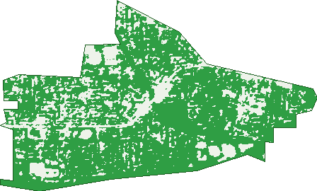
Green: 10 m cells where trees dominate, satellite 2021. Blue: water. The line is the suburb boundary.
| Canopy share, 1 m canopy height map, 2020 | 26.6% |
|---|---|
| Land with trees, 10 m satellite map, 2021 | 83.2% |
Demographics
Unemployment 3.5% · Labour-force participation 66.2%
Population by age in Heathmont
| 0-4 | 578 |
|---|---|
| 5-14 | 1,341 |
| 15-19 | 626 |
| 20-24 | 498 |
| 25-34 | 1,017 |
| 35-44 | 1,493 |
| 45-54 | 1,471 |
| 55-64 | 1,131 |
| 65-74 | 942 |
| 75-84 | 602 |
| 85+ | 222 |
Dwelling types in Heathmont
| House | 3,330 |
|---|---|
| Townhouse | 212 |
| Apartment | 11 |
| Other | 0 |
Households by weekly income in Heathmont
| <$650 | 415 |
|---|---|
| $650-1,499 | 801 |
| $1,500-2,999 | 1,010 |
| $3,000+ | 1,156 |
Top ancestries in Heathmont
| English | 3,833 |
|---|---|
| Australian | 3,390 |
| Irish | 1,196 |
| Scottish | 1,151 |
| Other | 1,008 |
| Chinese | 757 |
Housing tenure in Heathmont
| Owned | 1,362 |
|---|---|
| Mortgage | 1,504 |
| Rented | 639 |
| Other | 21 |
Cars per household in Heathmont
| 0 | 107 |
|---|---|
| 1 | 1,159 |
| 2 | 1,594 |
| 3 | 446 |
| 4+ | 226 |
Commute to work in Heathmont
| Car | 2,402 |
|---|---|
| Train | 102 |
| Bus | 11 |
| Tram/ferry | 0 |
| Walked | 45 |
| Bicycle | 16 |
| Home | 1,700 |
Top countries of birth in Heathmont
| England | 338 |
|---|---|
| China | 282 |
| India | 247 |
| Malaysia | 105 |
| New Zealand | 96 |
| Myanmar | 72 |
Languages used at home in Heathmont
| Mandarin | 383 |
|---|---|
| Cantonese | 164 |
| Hindi | 70 |
| Korean | 66 |
| Greek | 53 |
| Spanish | 52 |
Birds & Wildlife Nearby
102,067 bird observations recorded near Heathmont — most often seen:
- Little Raven (6,384)
- Common Myna (5,946)
- Rainbow Lorikeet (5,879)
- Noisy Miner (5,631)
- Australian Magpie (5,564)
- Pacific Black Duck (4,908)
- Red Wattlebird (4,488)
- Spotted Turtle-dove (4,162)
- Eurasian Blackbird (3,747)
- Grey Butcherbird (3,743)
- Australian Wood Duck (3,692)
- Pied Currawong (3,376)
- Magpie-lark (3,366)
Show all 30 birds recorded near Heathmont
- Brown Thornbill (3,313)
- Southern Victoria Australian Magpie (3,064)
- Dusky Moorhen (3,008)
- Sulphur-crested Cockatoo (2,964)
- Laughing Kookaburra (2,735)
- Crimson Rosella (2,534)
- Galah (2,516)
- Eastern Rosella (2,410)
- Welcome Swallow (2,326)
- Eastern Rainbow Lorikeet (2,269)
- Australian White Ibis (2,198)
- Chestnut Teal (2,037)
- Eastern Red Wattlebird (2,034)
- Southern Noisy Miner (1,973)
- Grey Fantail (1,956)
- Superb Fairy-wren (1,936)
- Common Bronzewing (1,908)
Sightings reported by observers, not a survey, so the counts show what people record rather than what lives here. Source: Atlas of Living Australia.
Nearby Suburbs
The closest suburbs to Heathmont:
- Ringwood East (2.1 km)
- Ringwood (2.2 km)
- Bayswater (2.6 km)
- Wantirna (2.8 km)
- Bayswater North (3.4 km)
- Croydon South (3.4 km)
- Vermont (4 km)
- Ringwood North (4 km)
Embed this suburb
Add this free Heathmont stat card to your own site — just copy the code:
Preview:
Cite this page
Quoting these figures? Copy the credit line:
Keep an eye on Heathmont
One email when this data meaningfully changes — new census figures, prices, rankings. No spam, unsubscribe anytime.
Streets
- Adrian Court (19)
- Alkira Court (19)
- Allens Road (71)
- Alvena Crescent (48)
- Anne Court (10)
- Aringa Court (11)
- Armstrong Road (67)
- Atunga Court (17)
- Aumann Street (9)
- Balfour Avenue (78)
- Bangor Court (15)
- Banksia Court (33)
- Barbara Court (8)
- Barnic Road (26)
- Barrow Drive (56)
- Bass Court (10)
- Bayley Close (7)
- Beard Court (9)
- Bedford Court (39)
- Bedford Road (92)
- Bellbird Court (7)
- Bennett Avenue (29)
- Beverley Court (9)
- Blenheim Street (19)
- Bligh Court (4)
- Bromley Close (8)
- Bronaldi Street (11)
- Bungalook Road W (13)
- Campbell Street (154)
- Canterbury Road (542)
- Carbery Place (8)
- Carruthers Court (8)
- Christine Court (8)
- Coleman Street (24)
- Cormack Court (16)
- Coven Avenue (66)
- Craig Court (19)
- Culverlands Road (18)
- Cumming Street (10)
- Cuthbert Street (111)
- Daisy Street (62)
- Danielle Crescent (45)
- Dawsons Glen (8)
- Devon Avenue (28)
- Dickasons Road (76)
- Dirkala Avenue (57)
- Doulton Avenue (29)
- Dresden Avenue (23)
- Eden Avenue (44)
- Edith Street (6)
- Edna Street (50)
- Erica Court (19)
- Erica Crescent (33)
- Eton Court (6)
- Fairbank Avenue (22)
- Frances Street (41)
- Fremont Street (30)
- Great Ryrie Street (83)
- Hardeep Place (11)
- Hardy Crescent (30)
- Harriet Street (23)
- Headline Court (17)
- Heath Court (7)
- Heathmont Road (125)
- Ilford Road (11)
- Janet Court (8)
- Jarma Road (65)
- Joan Court (9)
- Joel Court (31)
- Karen Court (4)
- Karista Avenue (11)
- Kenbry Road (18)
- Leawarra Drive (15)
- Lee Court (26)
- Lena Grove (3)
- Leoni Avenue (21)
- Lisgoold Street (13)
- Locksley Close (6)
- Lorienne Street (41)
- Louis Street (30)
- Lowen Avenue (7)
- Lucinda Close (8)
- Madigan Court (14)
- Marden Place (19)
- Markhill Place (9)
- Marlborough Road (83)
- Martin Street (13)
- Miller Road (36)
- Milton Street (26)
- Mont Court (13)
- Mountain View Road (16)
- Muller Court (9)
- Myrtle Avenue (81)
- Neil Street (18)
- Orchard Grove (42)
- Orchid Street (37)
- Parkhaven Drive (17)
- Pett Court (4)
- Philip Street (27)
- Piper Place (6)
- Pleasant Drive (28)
- Portsmouth Street (30)
- Possum Lane (32)
- Poulton Close (21)
- Pump Street (7)
- Reilly Street (2)
- Reumah Court (25)
- Ross Crescent (38)
- Royal Avenue (64)
- Salisbury Court (29)
- Scott Street (1)
- Sharps Court (7)
- Sheridan Court (21)
- Simla Court (8)
- Simpsons Court (8)
- Skyline Place (38)
- Stoda Street (61)
- Sunset Drive (45)
- Swain Court (16)
- Tagell Road (56)
- The Boulevard (54)
- The Greenway (61)
- The Outlook (13)
- Treetop Court (17)
- Tudor Court (18)
- Valdale Court (5)
- Vale Street (29)
- Valerie Court (21)
- View Court (5)
- Viviani Crescent (113)
- Wainui Avenue (16)
- Wallis Court (4)
- Wantirna Road (1)
- Washusen Road (37)
- Waterloo Street (82)
- Waters Grove (25)
- Wayne Court (14)
- Wendy Court (7)
- Westmore Drive (23)
- Wollahra Place (24)
- Woodlands Road (41)
- Yallamba Place (10)
- Yarang Court (15)
- York Court (5)