Heathcote VIC 3523
2,416 addresses · 149 streets
Bendigo Electorate › Greater Bendigo LGA › Heathcote · 102 km from Melbourne
📦 Thinking of moving here? Read the Heathcote moving guide

Living Here
Heathcote is a suburb of Victoria, home to about 2,962 people, with a median age of 57. The typical household earns around $946 a week, with median rent near $255 a week. Most homes are houses. About 84% of households own their home and 15% rent. Most workers drive to work. Common community backgrounds include English, Australian, Irish. On the ABS socio-economic scale it sits in decile 2 of 10 nationally — a more disadvantaged area. The median house sells for about $502,500.
Over time — Census 2001 → 2021
Dashed line: district figures for the Heathcote statistical area (SA2), the smallest area the ABS published before 2011. Solid line: Heathcote itself.
Getting Around & Local Services
1 supermarket
1 pharmacy
1 medical clinic
1 dentist
1 optometrist
1 hospital
2 childcare & kindergartens
1 library
2 post offices
3 gyms & sports centres
1 golf club
1 playground
1 butcher
1 hardware store
1 hairdresser
2 mechanics
Getting around. Airport: Bendigo Airport, 40.3 km north-west.
Sport & Recreation
7 facilities recorded in Heathcote.
- Barrack Reserve Australian Rules Football, Cricket
- Heathcote Bowling Club Lawn Bowls
- Heathcote Golf Course Golf
- Heathcote Showgrounds Cricket
- Heathcote Skate Park BMX, Skating
- Heathcote Swimming Pool Swimming
- Heathcote Tennis Club Tennis (Outdoor)
Socio-economic Standing
Deciles from 1 (lowest) to 10 (highest), against all Australian suburbs. The overall figure weighs advantage and disadvantage together; economic resources counts income and housing, and education & jobs counts qualifications and occupation. They often differ. Source: ABS SEIFA 2021.
Median Sale Prices
Median of recorded sales in the period, not a valuation. Source: Victorian Property Sales Report, Land Use Victoria.
Tree cover
🌳 Tree canopy: 37.3% share of land under canopy · satellite map, 2020
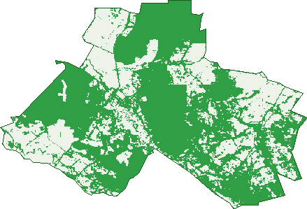
Green: 10 m cells where trees dominate, satellite 2021. Blue: water. The line is the suburb boundary.
| Canopy share, 1 m canopy height map, 2020 | 37.3% |
|---|---|
| Land with trees, 10 m satellite map, 2021 | 62.7% |
Demographics
Unemployment 5.1% · Labour-force participation 40.1%
Population by age in Heathcote
| 0-4 | 95 |
|---|---|
| 5-14 | 239 |
| 15-19 | 99 |
| 20-24 | 86 |
| 25-34 | 205 |
| 35-44 | 255 |
| 45-54 | 390 |
| 55-64 | 539 |
| 65-74 | 552 |
| 75-84 | 371 |
| 85+ | 120 |
Dwelling types in Heathcote
| House | 1,191 |
|---|---|
| Townhouse | 30 |
| Apartment | 6 |
| Other | 23 |
Households by weekly income in Heathcote
| <$650 | 356 |
|---|---|
| $650-1,499 | 449 |
| $1,500-2,999 | 249 |
| $3,000+ | 92 |
Top ancestries in Heathcote
| English | 1,208 |
|---|---|
| Australian | 1,061 |
| Irish | 408 |
| Ancestry NS | 359 |
| Scottish | 335 |
| German | 122 |
Housing tenure in Heathcote
| Owned | 642 |
|---|---|
| Mortgage | 373 |
| Rented | 176 |
| Other | 20 |
Cars per household in Heathcote
| 0 | 37 |
|---|---|
| 1 | 440 |
| 2 | 466 |
| 3 | 167 |
| 4+ | 105 |
Commute to work in Heathcote
| Car | 664 |
|---|---|
| Train | 3 |
| Bus | 0 |
| Tram/ferry | 0 |
| Walked | 23 |
| Bicycle | 0 |
| Home | 152 |
Top countries of birth in Heathcote
| England | 119 |
|---|---|
| New Zealand | 42 |
| Germany | 23 |
| Italy | 16 |
| Netherlands | 15 |
| Philippines | 14 |
Languages used at home in Heathcote
| Italian | 15 |
|---|---|
| German | 8 |
| Tagalog | 7 |
| Cantonese | 6 |
| Mandarin | 6 |
| Turkish | 6 |
Birds & Wildlife Nearby
49,483 bird observations recorded near Heathcote — most often seen:
- Red Wattlebird (2,653)
- Little Raven (2,518)
- Galah (2,342)
- Sulphur-crested Cockatoo (2,317)
- Australian Magpie (2,194)
- Superb Fairy-wren (2,160)
- Grey Shrike-thrush (1,931)
- Rainbow Lorikeet (1,915)
- Silvereye (1,778)
- Weebill (1,764)
- Yellow Thornbill (1,762)
- Coastal Spotted Pardalote (1,739)
- Eurasian Blackbird (1,723)
Show all 30 birds recorded near Heathcote
- New Holland Honeyeater (1,672)
- Welcome Swallow (1,656)
- Yellow-faced Honeyeater (1,549)
- Pied Currawong (1,505)
- House Sparrow (1,486)
- Southern Masked Lapwing (1,469)
- Yellow-rumped Thornbill (1,416)
- Western Striated Pardalote (1,372)
- Common Myna (1,343)
- Australian Wood Duck (1,250)
- Rufous Whistler (1,244)
- South-eastern Grey Fantail (1,241)
- Laughing Kookaburra (1,130)
- Long-billed Corella (1,125)
- Fuscous Honeyeater (1,114)
- Eastern Rosella (1,072)
- Brown-headed Honeyeater (1,043)
Sightings reported by observers, not a survey, so the counts show what people record rather than what lives here. Source: Atlas of Living Australia.
Nearby Suburbs
The closest suburbs to Heathcote:
- Argyle (3.2 km)
- Costerfield (8.7 km)
- Heathcote South (8.8 km)
- Derrinal (10.6 km)
- Ladys Pass (10.6 km)
- Mia Mia (12.3 km)
- Mount Camel (12.3 km)
- Knowsley (14.8 km)
Embed this suburb
Add this free Heathcote stat card to your own site — just copy the code:
Preview:
Cite this page
Quoting these figures? Copy the credit line:
Keep an eye on Heathcote
One email when this data meaningfully changes — new census figures, prices, rankings. No spam, unsubscribe anytime.
Streets
- Adairs Lane (4)
- Ambers Drive (7)
- Anderson Court (9)
- Armstrong Street (7)
- Back Kyneton Road (19)
- Barrack Street (10)
- Bates Court (13)
- Baynton Street (3)
- Beauchamp Street (44)
- Belfry Close (1)
- Bennett Street (22)
- Biggins Lane (7)
- Bonneys Lane (7)
- Boomerang Place (13)
- Boughyard Lane (6)
- Bradleys Lane (5)
- Brennan Road (9)
- Broodie Street (13)
- Buglers Lane (2)
- Burns Court (6)
- Caldwell Street (90)
- Camp Street (7)
- Campbells Lane (2)
- Carboon Lane (4)
- Chambers Lane (3)
- Chapmans Lane (5)
- Chauncey Street (36)
- Christie Street (4)
- Clouston Court (4)
- Codes Lane (8)
- Commins Lane (3)
- Commissioners Flat Lane (3)
- Common Dam Track (1)
- Connell Court (1)
- Cook Court (5)
- Coppermine Road (2)
- Craven Crescent (11)
- Creek Drive (3)
- Depot Road (5)
- Doolan Crescent (27)
- Drummonds Lane (6)
- Ebden Street (93)
- Etheridge Court (6)
- Fairy Dell Court (24)
- Farley Road (5)
- Field Road (6)
- Five Gums Lane (5)
- Flea Street (8)
- Forest Drive (3)
- Golden Gully Road (4)
- Golf Links Lane (20)
- Greens Lane (2)
- Hakea Court (6)
- Hall Road (16)
- Hamilton Court (10)
- Harris Lane (2)
- Hassells Lane (4)
- Heathcote-nagambie Road (54)
- Heathcote-north Costerfield Road (34)
- Heathcote-redesdale Road (45)
- Heenans Lane (9)
- Herriot Street (28)
- High Street (304)
- Hirds Road (6)
- Hookes Lane (3)
- Horsburgh Court (7)
- Hospital Street (60)
- Hunter Place (9)
- Hylands Lane (35)
- Jackas Lane (6)
- Jennings Street (3)
- Jones Court (6)
- Kemps Lane (3)
- Kilmore Road (61)
- Kilroy Street (12)
- Last Street (7)
- Mandel Court (10)
- Marshall Crescent (12)
- Mccarthy Drive (22)
- Mcivor Highway (24)
- Mcivor Street (3)
- Mcmahon Street (20)
- Mcnutts Lane (11)
- Meadows Lane (21)
- Mears Lane (2)
- Mia Mia-derrinal Road (2)
- Milhaven Lane (9)
- Mitchell Street (33)
- Morrison Court (8)
- Mt Ida Lane (2)
- Newtons Lane (1)
- Nicholsons Lane (4)
- Northern Highway (40)
- Obrien Court (22)
- Old Railway Reserve Road (1)
- Olivia Court (4)
- Palling Road (11)
- Palm Court (10)
- Parkinson Court (9)
- Parrebin Drive (16)
- Patterson Street (30)
- Peels Lane (7)
- Perrys Lane (1)
- Pink Cliffs Road (27)
- Plantation Road (11)
- Playne Street (79)
- Pohlman Street (24)
- Railway Street (1)
- Redburns Lane (9)
- Redgum Court (10)
- Redleaf Close (9)
- Robinson Street (6)
- Romano Court (7)
- Ross Street (36)
- Routledge Street (18)
- Rowbothams Track (3)
- Rushall Road (5)
- Ryans Lane (7)
- Sailors Gully Court (6)
- Sangsters Lane (5)
- Scotts Crescent (10)
- Scullys Lane (35)
- Shakespere Street (39)
- Shannon Rise (2)
- Shurans Lane (3)
- Speed Street (13)
- Spring Flat Road (19)
- Stephenson Street (2)
- Stewart Street (5)
- Tehan Court (9)
- Thomas Street (19)
- Thompsons Lane (16)
- Tobins Lane (1)
- Tranter Street (1)
- Travers Lane (10)
- Trellis Drive (16)
- Tuscan Court (10)
- Valli Street (5)
- Vaughans Lane (11)
- Victoria Hill Road (14)
- Walker Road (5)
- Wappentake Lane (19)
- Warren Road (12)
- Warrowitue-forest Road (43)
- Wattle Drive (26)
- Wilson Road (20)
- Wright Street (88)
- Yemm Lane (10)
- Youngs Lane (12)