Healesville VIC 3777
4,691 addresses · 202 streets
Casey Electorate › Yarra Ranges LGA › Healesville · 52 km from Melbourne
📦 Thinking of moving here? Read the Healesville moving guide

Living Here
Healesville is a suburb of Victoria, home to about 7,589 people, with a median age of 46. The typical household earns around $1,472 a week, with median rent near $350 a week. Most homes are houses. About 81% of households own their home and 18% rent. Most workers drive to work. Common community backgrounds include English, Australian, Irish. On the ABS socio-economic scale it sits in decile 5 of 10 nationally — a mid-range area. The median house sells for about $775,000.
Over time — Census 2001 → 2021
Dashed line: district figures for the Healesville - Yarra Glen statistical area (SA2), the smallest area the ABS published before 2011. Solid line: Healesville itself.
Getting Around & Local Services
4 supermarkets
1 hospital
1 childcare centre
1 post office
3 gyms & sports centres
1 playground
Getting around. Airport: Moorabbin Airport, 51.5 km south-west.
Sport & Recreation
5 facilities recorded in Healesville.
- Don Road Sporting Complex Australian Rules Football, Cricket, Soccer, Tennis (Outdoor)
- Don Road Sports Complex Equestrian
- Healsville Bowls Club Lawn Bowls
- Healsville Golf Club Golf
- Queens Park Australian Rules Football, Cricket, Soccer, Swimming, Tennis (Outdoor)
Socio-economic Standing
Deciles from 1 (lowest) to 10 (highest), against all Australian suburbs. The overall figure weighs advantage and disadvantage together; economic resources counts income and housing, and education & jobs counts qualifications and occupation. They often differ. Source: ABS SEIFA 2021.
Median Sale Prices
Median of recorded sales in the period, not a valuation. Source: Victorian Property Sales Report, Land Use Victoria.
Tree cover
🌳 Tree canopy: 66.6% share of land under canopy · satellite map, 2020
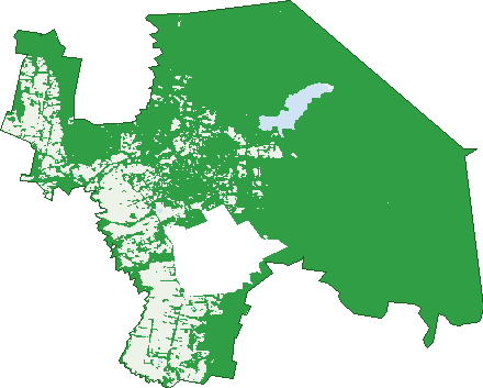
Green: 10 m cells where trees dominate, satellite 2021. Blue: water. The line is the suburb boundary.
| Canopy share, 1 m canopy height map, 2020 | 66.6% |
|---|---|
| Land with trees, 10 m satellite map, 2021 | 83.7% |
Demographics
Unemployment 3.5% · Labour-force participation 56.9%
Population by age in Healesville
| 0-4 | 386 |
|---|---|
| 5-14 | 864 |
| 15-19 | 423 |
| 20-24 | 338 |
| 25-34 | 773 |
| 35-44 | 877 |
| 45-54 | 1,003 |
| 55-64 | 1,131 |
| 65-74 | 906 |
| 75-84 | 634 |
| 85+ | 259 |
Dwelling types in Healesville
| House | 2,580 |
|---|---|
| Townhouse | 288 |
| Apartment | 11 |
| Other | 0 |
Households by weekly income in Healesville
| <$650 | 546 |
|---|---|
| $650-1,499 | 816 |
| $1,500-2,999 | 854 |
| $3,000+ | 481 |
Top ancestries in Healesville
| English | 3,493 |
|---|---|
| Australian | 2,880 |
| Irish | 1,037 |
| Scottish | 977 |
| Other | 445 |
| Ancestry NS | 433 |
Housing tenure in Healesville
| Owned | 1,161 |
|---|---|
| Mortgage | 1,152 |
| Rented | 499 |
| Other | 39 |
Cars per household in Healesville
| 0 | 100 |
|---|---|
| 1 | 948 |
| 2 | 1,103 |
| 3 | 404 |
| 4+ | 299 |
Commute to work in Healesville
| Car | 2,008 |
|---|---|
| Train | 3 |
| Bus | 8 |
| Tram/ferry | 0 |
| Walked | 104 |
| Bicycle | 15 |
| Home | 716 |
Top countries of birth in Healesville
| England | 408 |
|---|---|
| New Zealand | 126 |
| Netherlands | 70 |
| Germany | 60 |
| Scotland | 58 |
| Italy | 36 |
Languages used at home in Healesville
| German | 52 |
|---|---|
| Italian | 43 |
| Mandarin | 24 |
| Thai | 19 |
| French | 18 |
| Greek | 18 |
Birds & Wildlife Nearby
32,428 bird observations recorded near Healesville — most often seen:
- Australian White Ibis (1,884)
- Superb Fairy-wren (1,646)
- Australian Magpie (1,603)
- Crimson Rosella (1,469)
- Sulphur-crested Cockatoo (1,449)
- Red Wattlebird (1,420)
- Eurasian Blackbird (1,347)
- Common Bronzewing (1,338)
- Laughing Kookaburra (1,309)
- Galah (1,251)
- Grey Fantail (1,185)
- Pacific Black Duck (1,149)
- Australian King-parrot (1,078)
Show all 30 birds recorded near Healesville
- Rainbow Lorikeet (1,078)
- Eastern Spinebill (1,047)
- Brown Thornbill (1,036)
- Pied Currawong (1,028)
- Australian Wood Duck (944)
- Australasian Purple Swamphen (939)
- Dusky Moorhen (928)
- Common Myna (927)
- Yellow-faced Honeyeater (901)
- Little Raven (868)
- White-browed Scrubwren (843)
- Eastern Yellow Robin (730)
- Red-browed Finch (702)
- White-naped Honeyeater (640)
- Grey Shrike-thrush (566)
- Spotted Pardalote (563)
- Magpie-lark (560)
Sightings reported by observers, not a survey, so the counts show what people record rather than what lives here. Source: Atlas of Living Australia.
Nearby Suburbs
The closest suburbs to Healesville:
- Badger Creek (3.6 km)
- Chum Creek (4.5 km)
- Tarrawarra (6.9 km)
- Mount Toolebewong (8.2 km)
- Gruyere (10.8 km)
- Dixons Creek (10.8 km)
- Don Valley (11.6 km)
- Yarra Glen (12.8 km)
Embed this suburb
Add this free Healesville stat card to your own site — just copy the code:
Preview:
Cite this page
Quoting these figures? Copy the credit line:
Keep an eye on Healesville
One email when this data meaningfully changes — new census figures, prices, rankings. No spam, unsubscribe anytime.
Streets
- Adelia Close (7)
- Airlie Road (25)
- Albert Road (24)
- Amelia Avenue (4)
- Anderson Road (24)
- Andrea Court (14)
- Ardill Street (6)
- Argoon Road (5)
- Auburn Road (71)
- Ayres Road (60)
- Baden Powell Drive (27)
- Badger Creek Road (119)
- Badger Weir Road (1)
- Barak Lane (6)
- Barra Close (5)
- Bella Vista Crescent (11)
- Benton Road (34)
- Beverley Drive (28)
- Birdwood Avenue (33)
- Blannin Street (34)
- Bona Avenue (20)
- Bonnies View (1)
- Bradshaw Drive (13)
- Bridges Road (6)
- Brumfield Road (23)
- Caladenia Close (6)
- Camerons Road (35)
- Campbell Road (12)
- Casey Street (5)
- Centre Grove (36)
- Cherley Rise (12)
- Christie Parade (11)
- Chum Creek Road (36)
- Church Street (9)
- Clifford Grove (14)
- Clive Avenue (20)
- Cornelius Crescent (28)
- Cornish Road (16)
- Cranbrook Place (10)
- Crisp Street (1)
- Crosley Street (12)
- Crowley Road (71)
- Currawong Road (17)
- Curzon Avenue (21)
- Daley Close (5)
- Dingley Dell Road (13)
- Don Road (168)
- Donna Buang Road (3)
- Donnellys Weir Road (14)
- Donovans Road (10)
- Dorothy Street (18)
- Dowd Road (17)
- Eadie Avenue (15)
- Edward Street (23)
- Elamo Road (103)
- Eleva Road (23)
- Eli Bates Court (6)
- Elliot Close (9)
- Elsie Grove (7)
- Evelyn Grove (24)
- Fantail Terrace (5)
- Farnham Road (86)
- Fernbank Road (11)
- Furmston Lane (1)
- George Road (15)
- Gibbs Road (25)
- Glenfern Avenue (1)
- Glenfern Road (2)
- Gloria Close (6)
- Goondah Lane (15)
- Graceburn Avenue (29)
- Graceburn Road (3)
- Grandview Crescent (11)
- Grant Crescent (12)
- Green Street (28)
- Haig Avenue (20)
- Hall Road (2)
- Harker Street (42)
- Hazel Crescent (11)
- Hazford Street (28)
- Healesville-kinglake Road (20)
- Healesville-koo Wee Rup Road (53)
- Healesville-yarra Glen Road (48)
- Henry Street (28)
- Heritage Lane (4)
- High Street (23)
- Highett Road (1)
- Hillcrest Grove (23)
- Hillview Court (8)
- Hit Or Miss Road (2)
- Holland Street (28)
- Hunter Road (36)
- Joffre Road (9)
- Juel Crescent (23)
- Juliet Avenue (19)
- Juliet Crescent (22)
- Kalamunda Terrace (20)
- Karinya Close (7)
- Lalors Lane (11)
- Lalors Road (61)
- Lawrence Court (7)
- Leitch Close (8)
- Lewis Road (4)
- Lilydale Road (16)
- Links Grove (5)
- Long Gully Road (28)
- Lowes Road (7)
- Manse Street (12)
- Margaret Road (10)
- Marna Street (56)
- Maroondah Highway (586)
- Maroondah Parade (18)
- Martin Lane (3)
- Mason Close (4)
- Mazeepa Street (1)
- Mcgregor Avenue (60)
- Mcgregor Avenue E (9)
- Mcgrettons Road (68)
- Mckenzie Avenue (9)
- Merrans Road (10)
- Merton Grove (15)
- Miller Road (5)
- Miller Street (2)
- Monda Avenue (15)
- Monda Parade (3)
- Montpellier Street (16)
- Mt Riddell Road (90)
- Mt Vue Road (20)
- Mustang Lane (7)
- Myers Creek Road (49)
- Nagoondie Lane (11)
- Newgrove Road (67)
- Norris Crescent (16)
- Oakridge Rise (17)
- Old Fernshaw Road (49)
- Old Healesville Road (10)
- Olive Grove (6)
- Pantons Spur Road (7)
- Parisi Close (6)
- Parkhaven Court (16)
- Pemberley Close (6)
- Penny Lane (9)
- Pierce Rise (15)
- Pilmer Road (8)
- Pine Avenue (1)
- Pockett Lane (11)
- Pockett Road (15)
- Pollard Parade (5)
- Preston Way (6)
- Prince Street (16)
- Railway Parade (3)
- Raymond Court (12)
- Rebecca Court (3)
- River Street (40)
- Riverflat Close (4)
- Robin Parade (20)
- Romeo Road (29)
- Ronde Court (9)
- Rosella Crescent (12)
- Rosemont Mews (8)
- Rowson Road (1)
- Ruby Close (5)
- Rutter Avenue (24)
- Ryans Road (39)
- Ryrie Street (28)
- Saxil Grove (9)
- Shirley Lane (8)
- Silverleaf Place (18)
- Sloss Road (7)
- Smith Street (105)
- Spencer Close (5)
- Spinebill Court (7)
- St Leonards Road (137)
- St Margarets Road (5)
- Stanley Road (8)
- Steel Street (56)
- Stephens Road (41)
- Syme Road (1)
- Symons Street (62)
- Taber Lane (1)
- Tevlin Place (5)
- The Sanctuary Close (4)
- Thomas Road (76)
- Thornbill Close (8)
- Trench Farm Road (5)
- Turners Lane (5)
- Valley Farm Road (9)
- View Street (14)
- Vimy Ridge (1)
- Vine Close (9)
- Walker Street (11)
- Walkers Lane (16)
- Wallace Parade (31)
- Wattlebird Way (10)
- Wattles Court (5)
- Weiss Road (2)
- Westmount Road (42)
- Whelans Road (8)
- White Street (18)
- Will Place (5)
- Wilson Street (3)
- Zoe Louise Drive (27)