Hastings VIC 3915
7,069 addresses · 231 streets
Flinders Electorate › Mornington Peninsula LGA › Hastings · 58 km from Melbourne
📦 Thinking of moving here? Read the Hastings moving guide

Living Here
Hastings is a suburb of Victoria, home to about 10,369 people, with a median age of 41. The typical household earns around $1,197 a week, with median rent near $320 a week. Most homes are houses. About 66% of households own their home and 32% rent. Most workers drive to work. Common community backgrounds include English, Australian, Scottish. On the ABS socio-economic scale it sits in decile 2 of 10 nationally — a more disadvantaged area. The median house sells for about $670,000.
Over time — Census 2001 → 2021
Dashed line: district figures for the Hastings - Somers statistical area (SA2), the smallest area the ABS published before 2011. Solid line: Hastings itself.
Getting Around & Local Services
3 supermarkets
1 Catholic church
1 medical clinic
1 childcare centre
1 library
1 post office
2 gyms & sports centres
1 playground
1 dog park
2 hardware stores
2 plumbers
1 place to stay
Getting around. Train station: Hastings, 250 m south-east · Airport: Moorabbin Airport, 36.9 km north.
Sport & Recreation
7 facilities recorded in Hastings.
- Contours Hastings Fitness / Gymnasium Workouts
- Hastings Community Hub (Fitness & Leisure Centre) Basketball
- Hastings Park Australian Rules Football, Cricket
- Hastings Yacht Club Sailing
- Hastings' Tennis & Bowls Club Lawn Bowls, Netball, Tennis (Outdoor)
- Pelican Park Recreation Centre Fitness / Gymnasium Workouts, Swimming
- Westernport Athletics Track Athletics
Socio-economic Standing
Deciles from 1 (lowest) to 10 (highest), against all Australian suburbs. The overall figure weighs advantage and disadvantage together; economic resources counts income and housing, and education & jobs counts qualifications and occupation. They often differ. Source: ABS SEIFA 2021.
Median Sale Prices
Median of recorded sales in the period, not a valuation. Source: Victorian Property Sales Report, Land Use Victoria.
Tree cover
🌳 Tree canopy: 15.5% share of land under canopy · satellite map, 2020
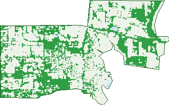
Green: 10 m cells where trees dominate, satellite 2021. Blue: water. The line is the suburb boundary.
| Canopy share, 1 m canopy height map, 2020 | 15.5% |
|---|---|
| Land with trees, 10 m satellite map, 2021 | 37.1% |
Demographics
Unemployment 4.5% · Labour-force participation 51.2%
Population by age in Hastings
| 0-4 | 601 |
|---|---|
| 5-14 | 1,300 |
| 15-19 | 567 |
| 20-24 | 492 |
| 25-34 | 1,351 |
| 35-44 | 1,214 |
| 45-54 | 1,177 |
| 55-64 | 1,202 |
| 65-74 | 1,276 |
| 75-84 | 895 |
| 85+ | 302 |
Dwelling types in Hastings
| House | 3,049 |
|---|---|
| Townhouse | 1,035 |
| Apartment | 58 |
| Other | 44 |
Households by weekly income in Hastings
| <$650 | 989 |
|---|---|
| $650-1,499 | 1,371 |
| $1,500-2,999 | 1,088 |
| $3,000+ | 417 |
Top ancestries in Hastings
| English | 4,602 |
|---|---|
| Australian | 4,302 |
| Scottish | 1,052 |
| Irish | 1,045 |
| Ancestry NS | 761 |
| Other | 540 |
Housing tenure in Hastings
| Owned | 1,354 |
|---|---|
| Mortgage | 1,365 |
| Rented | 1,290 |
| Other | 82 |
Cars per household in Hastings
| 0 | 274 |
|---|---|
| 1 | 1,742 |
| 2 | 1,431 |
| 3 | 427 |
| 4+ | 230 |
Commute to work in Hastings
| Car | 2,850 |
|---|---|
| Train | 4 |
| Bus | 8 |
| Tram/ferry | 0 |
| Walked | 91 |
| Bicycle | 20 |
| Home | 459 |
Top countries of birth in Hastings
| England | 662 |
|---|---|
| New Zealand | 174 |
| Philippines | 109 |
| Scotland | 94 |
| Netherlands | 60 |
| Germany | 58 |
Languages used at home in Hastings
| Tagalog | 48 |
|---|---|
| Thai | 42 |
| German | 32 |
| Filipino | 32 |
| Italian | 31 |
| Mandarin | 25 |
Birds & Wildlife Nearby
15,899 bird observations recorded near Hastings — most often seen:
- Australian White Ibis (947)
- Silver Gull (831)
- White-faced Heron (760)
- Common Starling (721)
- Noisy Miner (644)
- Eurasian Blackbird (635)
- Welcome Swallow (623)
- Common Myna (622)
- Little Raven (608)
- Australian Magpie (593)
- Magpie-lark (590)
- Black Swan (569)
- Masked Lapwing (550)
Show all 30 birds recorded near Hastings
- Red Wattlebird (550)
- Superb Fairy-wren (536)
- Spotted Turtle-dove (510)
- Rainbow Lorikeet (505)
- Australian Pelican (491)
- Pacific Gull (466)
- Grey Fantail (449)
- Eastern Rosella (444)
- Little Pied Cormorant (440)
- Brown Thornbill (427)
- Galah (405)
- Grey Butcherbird (392)
- Grey Shrike-thrush (360)
- Southern Victoria Australian Magpie (343)
- Sulphur-crested Cockatoo (306)
- Little Wattlebird (302)
- Great Egret (280)
Sightings reported by observers, not a survey, so the counts show what people record rather than what lives here. Source: Atlas of Living Australia.
Nearby Suburbs
The closest suburbs to Hastings:
- Bittern (4.1 km)
- Tyabb (4.8 km)
- Crib Point (5.8 km)
- Tuerong (6.6 km)
- Hmas Cerberus (7.4 km)
- Moorooduc (8.5 km)
- Somerville (8.5 km)
- Balnarring (8.8 km)
Embed this suburb
Add this free Hastings stat card to your own site — just copy the code:
Preview:
Cite this page
Quoting these figures? Copy the credit line:
Keep an eye on Hastings
One email when this data meaningfully changes — new census figures, prices, rankings. No spam, unsubscribe anytime.
Streets
- Aitape Court (8)
- Albert Street (32)
- Alexander Drive (13)
- Alexandro Grove (18)
- Alfred Street (17)
- Anastasi Place (6)
- Andrew Court (8)
- Annette Court (29)
- Ardent Court (25)
- Arthur Street (28)
- Arunta Avenue (34)
- Ash Court (16)
- Auburn Court (8)
- Autumn Court (23)
- Babington Close (22)
- Barbecue Court (5)
- Barbette Court (13)
- Barclay Crescent (13)
- Barcoo Street (26)
- Bataan Court (9)
- Bayview Road (23)
- Beach Drive (40)
- Beachcomber Way (26)
- Beilby Court (28)
- Bellbird Lane (7)
- Bilgola Street (26)
- Boes Road (13)
- Brandary Place (12)
- Bray Street (40)
- Brydon Court (21)
- Burke Street (61)
- Callanan Street (2)
- Carinya Court (13)
- Carpenters Lane (2)
- Carpenters Lane N (31)
- Carpenters Lane S (39)
- Cathy Clifford Court (9)
- Cedar Drive (37)
- Cemetery Road (17)
- Chloe Drive (25)
- Church Street (67)
- Claire Court (9)
- Constantine Way (21)
- Cool Store Road (73)
- Coolart Road (22)
- Coral Place (19)
- Cordelia Street (16)
- Creek Close (4)
- Curacoa Drive (41)
- Curlew Court (12)
- Cutwater Street (31)
- Cypress Close (5)
- Danaher Way (3)
- Dellwood Court (17)
- Denham Road (2)
- Derwent Court (16)
- Dolphin Street (11)
- Douglas Street (75)
- Drake Court (11)
- Duchess Court (19)
- Dylan Drive (23)
- Edward Court (12)
- Edward Street (83)
- Elisa Place (61)
- Elizabeth Street (82)
- Ellery Street (14)
- Elm Court (2)
- Eman Terrace (11)
- Emily Place (9)
- Floyd Court (6)
- Forbes Place (10)
- Foreshore Avenue (6)
- Frankston-flinders Road (436)
- Fusta Lane (10)
- Gascoyne Court (11)
- Gaskin Avenue (27)
- Georgia Way (36)
- Glendale Avenue (63)
- Gold Court (31)
- Graydens Road (29)
- Greythorn Road (13)
- Haddock Street (3)
- Harbour Drive (15)
- Hastings Foreshore (1)
- Haywood Lane (3)
- Hendersons Road (78)
- Herring Street (27)
- High Street (496)
- Highland Avenue (11)
- Hilltop Rise (35)
- Hodgins Road (122)
- Huon Close (4)
- Isis Place (23)
- Jacaranda Court (12)
- James Hird Drive (39)
- James Street (40)
- Jamie Court (20)
- Jarrod Drive (17)
- Jenola Court (11)
- Jeremiahs Road (2)
- Jetty Way (8)
- Jillian Place (10)
- Jo Jo Court (6)
- John Coleman Close (15)
- John Vear Close (11)
- Junee Court (21)
- Kanowna Street (14)
- Kaz Court (3)
- Killick Street (15)
- Kimbla Court (7)
- King Street (102)
- Kingfisher Court (26)
- Knox Court (5)
- Kuan Yin Place (16)
- Kurrajong Street (33)
- Lachlan Court (10)
- Ladava Court (9)
- Lady Nada Way (3)
- Lae Court (9)
- Lantons Way (37)
- Laurel Court (18)
- Lea Court (9)
- Lefroy Lane (18)
- Lewis Street (13)
- Lintel Court (18)
- Lomica Drive (79)
- Long Island Drive (6)
- Lyall Street (90)
- Madang Court (23)
- Marine Parade (299)
- Mariners Way (28)
- Martin Street (86)
- Mary Grove (18)
- Matthew Circuit (52)
- Maurandra Close (12)
- Mayne Avenue (29)
- Mccallum Street (62)
- Melaleuca Drive (49)
- Menai Court (11)
- Merlebah Court (16)
- Michelle Drive (39)
- Mikhail Grove (17)
- Mirabella Court (11)
- Moresby Court (8)
- Morrah Street (37)
- Mullet Street (12)
- Natalie Court (26)
- Nicholas Court (50)
- Oak Court (4)
- Olivia Way (61)
- Onslow Court (14)
- Otway Court (20)
- Outlook Avenue (24)
- Ovens Court (10)
- Pauls Lane (16)
- Pearl Court (3)
- Pelican Place (8)
- Penshurst Avenue (26)
- Perrott Court (6)
- Phillip Court (28)
- Picnic Avenue (11)
- Pier Court (12)
- Pineview Lane (8)
- Pinewood Drive (53)
- Plymouth Street (28)
- Portside Drive (14)
- Pound Road (11)
- Pynble Court (6)
- Quadrant Court (14)
- Quality Court (17)
- Queen Street (92)
- Quickmatch Street (15)
- Railway Crescent (12)
- Rankin Road (74)
- Reid Parade (76)
- Robertson Street (5)
- Rosemary Drive (37)
- Ross Street (16)
- Sail Drive (32)
- Salmon Street (208)
- Samuel Court (11)
- Sandstone Court (9)
- Seahaven Street (20)
- Seaspray Court (8)
- Sefton Court (7)
- Shakti Place (15)
- Shelly Place (23)
- Simon Street (42)
- Skinner Street (118)
- Slocombe Close (8)
- Sovereign Drive (25)
- Spring Street (100)
- Spruce Drive (43)
- Stalwart Avenue (25)
- Star Point Place (89)
- Station Street (11)
- Stephen Street (23)
- Stuart Court (4)
- Sunset Rise (20)
- Tambar Place (9)
- Tara Drive (20)
- Taven Street (14)
- Teal Court (10)
- The Sheedy Way (14)
- Thomas Place (9)
- Thornhill Street (10)
- Torrens Court (9)
- Tuerong Place (12)
- Vampire Court (15)
- Vendetta Street (25)
- Victor Drive (23)
- Victoria Street (278)
- Villawood Drive (44)
- Voyager Street (11)
- Wallaroo Place (7)
- Wallis Drive (33)
- Warramunga Drive (23)
- Warranqite Crescent (58)
- Warrego Court (10)
- Warren Crescent (16)
- Whiting Place (2)
- William Street (21)
- Wills Street (16)
- Windrest Place (21)
- Windsor Lane (8)
- Wingala Court (12)
- Wolverene Street (18)
- Wongala Way (8)
- Wright Street (10)
- Yacht Court (10)
- Zen Place (2)