Fraser Rise VIC 3336
10,295 addresses · 426 streets
Gorton Electorate › Melton LGA › Fraser Rise · 25 km from Melbourne
📦 Thinking of moving here? Read the Fraser Rise moving guide

Living Here
A brand-new outer-western Melbourne growth suburb, Fraser Rise is almost entirely new family estates. A young median age of 31 and large households of 3.2 people prevail; combined household income is high at $2,276 a week, with rent around $431.
Fraser Rise is a suburb of Victoria, home to about 9,097 people, with a median age of 31. The typical household earns around $2,276 a week, with median rent near $431 a week. Most homes are houses. About 83% of households own their home and 17% rent. Most workers drive to work. Common community backgrounds include Australian, Indian, English. On the ABS socio-economic scale it sits in decile 8 of 10 nationally — a relatively advantaged area. The median house sells for about $702,500.
Over time — Census 2001 → 2021
Dashed line: district figures for the Hillside statistical area (SA2), the smallest area the ABS published before 2011. Solid line: Fraser Rise itself.
Getting Around & Local Services
1 supermarket
2 doctors & medical clinics
2 physiotherapists
1 optometrist
2 libraries
1 post office
5 service stations
3 gyms & sports centres
2 golf clubs
1 dog park
2 butchers
2 hardware stores
2 hairdressers
3 beauty salons
1 electrician
Getting around. Train station: Watergardens, 5.2 km east · Bus interchange: Watergardens Station, 5.2 km east · Airport: Melbourne Airport, 10.8 km east.
Socio-economic Standing
Deciles from 1 (lowest) to 10 (highest), against all Australian suburbs. The overall figure weighs advantage and disadvantage together; economic resources counts income and housing, and education & jobs counts qualifications and occupation. They often differ. Source: ABS SEIFA 2021.
Median Sale Prices
Median of recorded sales in the period, not a valuation. Source: Victorian Property Sales Report, Land Use Victoria.
Tree cover
🌳 Tree canopy: 0.5% share of land under canopy · satellite map, 2020
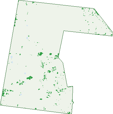
Green: 10 m cells where trees dominate, satellite 2021. Blue: water. The line is the suburb boundary.
| Canopy share, 1 m canopy height map, 2020 | 0.5% |
|---|---|
| Land with trees, 10 m satellite map, 2021 | 1.8% |
Demographics
Unemployment 4.5% · Labour-force participation 74.5%
Population by age in Fraser Rise
| 0-4 | 1,029 |
|---|---|
| 5-14 | 1,535 |
| 15-19 | 542 |
| 20-24 | 485 |
| 25-34 | 1,772 |
| 35-44 | 1,928 |
| 45-54 | 923 |
| 55-64 | 509 |
| 65-74 | 290 |
| 75-84 | 68 |
| 85+ | 11 |
Dwelling types in Fraser Rise
| House | 2,595 |
|---|---|
| Townhouse | 131 |
| Apartment | 0 |
| Other | 0 |
Households by weekly income in Fraser Rise
| <$650 | 165 |
|---|---|
| $650-1,499 | 482 |
| $1,500-2,999 | 1,173 |
| $3,000+ | 768 |
Top ancestries in Fraser Rise
| Other | 2,546 |
|---|---|
| Australian | 1,364 |
| Indian | 1,093 |
| English | 934 |
| Filipino | 776 |
| Italian | 761 |
Housing tenure in Fraser Rise
| Owned | 284 |
|---|---|
| Mortgage | 1,943 |
| Rented | 450 |
| Other | 14 |
Cars per household in Fraser Rise
| 0 | 26 |
|---|---|
| 1 | 675 |
| 2 | 1,412 |
| 3 | 439 |
| 4+ | 152 |
Commute to work in Fraser Rise
| Car | 2,738 |
|---|---|
| Train | 86 |
| Bus | 20 |
| Tram/ferry | 0 |
| Walked | 5 |
| Bicycle | 3 |
| Home | 1,070 |
Top countries of birth in Fraser Rise
| India | 1,042 |
|---|---|
| Philippines | 545 |
| Sri Lanka | 193 |
| New Zealand | 186 |
| Iraq | 128 |
| Vietnam | 112 |
Languages used at home in Fraser Rise
| Punjabi | 814 |
|---|---|
| Hindi | 316 |
| Tagalog | 309 |
| Arabic | 293 |
| Macedonian | 250 |
| Vietnamese | 223 |
Birds & Wildlife Nearby
9,320 bird observations recorded near Fraser Rise — most often seen:
- House Sparrow (807)
- Common Myna (782)
- Common Starling (544)
- Little Raven (542)
- Australian Magpie (401)
- Eurasian Blackbird (365)
- Rock Dove (350)
- Magpie-lark (349)
- Red Wattlebird (348)
- New Holland Honeyeater (340)
- Pacific Black Duck (323)
- Rainbow Lorikeet (316)
- Spotted Turtle-dove (300)
Show all 30 birds recorded near Fraser Rise
- Australasian Purple Swamphen (285)
- White-plumed Honeyeater (277)
- Dusky Moorhen (274)
- Southern Victoria Australian Magpie (257)
- Welcome Swallow (254)
- Eurasian Coot (250)
- Willie Wagtail (239)
- Black Swan (232)
- Crested Pigeon (222)
- Eastern Asian Spotted Dove (174)
- Little Pied Cormorant (174)
- Eastern New Holland Honeyeater (167)
- Masked Lapwing (153)
- White-faced Heron (153)
- Hoary-headed Grebe (149)
- Chestnut Teal (148)
- Hardhead (145)
Sightings reported by observers, not a survey, so the counts show what people record rather than what lives here. Source: Atlas of Living Australia.
Nearby Suburbs
The closest suburbs to Fraser Rise:
- Deanside (2.6 km)
- Bonnie Brook (2.8 km)
- Hillside (2.9 km)
- Taylors Hill (3.4 km)
- Caroline Springs (3.7 km)
- Aintree (4.4 km)
- Burnside Heights (4.5 km)
- Sydenham (4.5 km)
Embed this suburb
Add this free Fraser Rise stat card to your own site — just copy the code:
Preview:
Cite this page
Quoting these figures? Copy the credit line:
Keep an eye on Fraser Rise
One email when this data meaningfully changes — new census figures, prices, rankings. No spam, unsubscribe anytime.
Streets
- Acorn Way (8)
- Adams Drive (20)
- Adventure Avenue (20)
- Affluent Street (8)
- Aldgate Street (18)
- Aldred Street (20)
- Alicia Avenue (26)
- Alsace Way (4)
- Amalgam Avenue (4)
- Amazing Boulevard (36)
- Angelica Circuit (19)
- Anghor Drive (44)
- Anna Road (28)
- Annecy Boulevard (52)
- Aria Boulevard (25)
- Arid Close (3)
- Armstrong Walk (10)
- Asciano Lane (14)
- Aspire Boulevard (117)
- Assisi Street (20)
- Aubisque Close (48)
- Auburn Drive (41)
- Auden Lane (5)
- Avalon Street (27)
- Axe Way (5)
- Axis Avenue (13)
- Baker Terrace (6)
- Baldwin Road (34)
- Banjo Boulevard (73)
- Basalt Daisy Street (5)
- Basin Street (38)
- Bayest Walk (17)
- Beattys Road (77)
- Bellavista Crescent (46)
- Bianchi Close (4)
- Biodiversity Esplanade (12)
- Blade Circuit (32)
- Bleeker Way (9)
- Bliss Walk (7)
- Bobbin Street (9)
- Bohr Walk (9)
- Bonegilla Walk (15)
- Borcek Road (8)
- Boyd Lane (4)
- Bramley Place (9)
- Broad Road (23)
- Bulbine Lily Walk (8)
- Bullwheel Drive (11)
- Butterfly Walk (6)
- Cactus Street (25)
- Caleb Way (8)
- Canal Street (25)
- Canobie Street (6)
- Cantor Street (10)
- Caprise Road (18)
- Capulin View (9)
- Capulin Walk (9)
- Carlby Road (16)
- Caro Way (30)
- Carriage Drive (33)
- Cart Road (28)
- Casine Road (18)
- Catchment Drive (25)
- Cavesson Road (8)
- Cetona Street (40)
- Chalcot Circuit (48)
- Champion Walk (11)
- Chardonnay Rise (15)
- Cherish Street (53)
- Chiara Walk (4)
- Chiswell Avenue (28)
- Cinnamon Circuit (37)
- City Vista Court (136)
- Clapper Way (2)
- Climate Drive (1)
- Climate Street (26)
- Clipstone Crescent (62)
- Concorde Avenue (19)
- Cores Close (4)
- Corfu Street (22)
- Cottesmore Street (26)
- Counsel Road (9)
- Courtenay Promenade (93)
- Cowboy Walk (16)
- Crop Drive (24)
- Crown Drive (52)
- Dalveen Drive (21)
- Dash Street (25)
- Dauphine Way (2)
- Dawkins Avenue (29)
- Deanos Road (13)
- Debs Lane (9)
- Devonia Avenue (38)
- Dimitri Street (20)
- Dolcetto Way (9)
- Drill Street (14)
- Dunbar Street (15)
- Dunlop Way (9)
- Eaglecrest Avenue (22)
- Eastcastle Drive (23)
- Eastgate Street (29)
- Eclipse Avenue (27)
- Edison Street (15)
- Elm Drive (26)
- Emilia Circuit (28)
- Enchanted Road (18)
- English Road (8)
- Enterprise Circuit (94)
- Equestrian Street (18)
- Equinox Way (35)
- Erin Drive (38)
- Fairmont Crescent (46)
- Faith Walk (2)
- Falstaff Street (20)
- Farrier Boulevard (50)
- Ferro Street (3)
- Filly Walk (10)
- Flank Walk (9)
- Floresta Street (6)
- Florey Avenue (16)
- Florina Road (13)
- Florina Street (5)
- Foal Circuit (51)
- Forclaz Street (12)
- Forrester Grove (31)
- Fossicker Street (17)
- Fossil Way (16)
- Fox Street (8)
- Franca Avenue (37)
- Fredas Street (12)
- Freshwater Way (8)
- Friendship Place (13)
- Galibier Parade (24)
- Galveston Avenue (63)
- Gangur Way (29)
- Gathering Mews (3)
- Gec Boulevard (75)
- Gelding Street (12)
- Gerbei Way (1)
- Ginkgo Street (24)
- Glorious Walk (4)
- Gold Star Road (38)
- Gold Star Way (22)
- Goldrush Parade (11)
- Goldsworthy Drive (32)
- Gordes Street (18)
- Goulding Drive (30)
- Grandness Street (30)
- Granite Crescent (25)
- Grassbird Parade (18)
- Grassy Drive (5)
- Grassy Place (5)
- Greenback Lane (10)
- Greenback Way (10)
- Greenheart Street (20)
- Grimsby Avenue (18)
- Gumtree Way (7)
- Hampi Drive (23)
- Harmonica Walk (11)
- Hawking Crescent (93)
- Hector Street (12)
- Hem Parkway (27)
- Herd Lane (9)
- Higgins Street (60)
- Hillgate Grove (18)
- Holberry Street (14)
- Holyberry Street (14)
- Homage Avenue (50)
- Homebush Esplanade (32)
- Horseshoe Parade (53)
- Hume Drive (36)
- Hybrid Close (4)
- Hydra Way (4)
- Icanthus Street (5)
- Indulgence Avenue (47)
- Infinity Drive (60)
- Isthmus Link (9)
- Ivan Way (26)
- Ivanhoe Avenue (12)
- Jackpot Street (33)
- Jantar Way (15)
- Jardine Drive (31)
- Jermyn Street (12)
- Jermyn Terrace (10)
- Journey Drive (65)
- Joust Way (17)
- Jump Road (22)
- Kea Street (12)
- Keats Way (12)
- Kennedy Drive (51)
- Keynes Circuit (44)
- Kibris Avenue (8)
- Kibris Boulevard (7)
- Kippford Street (26)
- Kirkwood Avenue (18)
- Krateron Street (59)
- Kyah Street (33)
- Lando Street (23)
- Latigo Street (22)
- Lavant Road (36)
- Lavish Walk (6)
- Lavoro Street (10)
- Legrange Crescent (59)
- Lillypilly Street (24)
- Lilybloom Way (26)
- Linosa Road (1)
- Lockwood Court (24)
- Long Green Crescent (28)
- Lumberjack Drive (23)
- Lunar Way (38)
- Luxor Drive (37)
- Luxury Road (18)
- Magnificent Road (9)
- Mamaic Boulevard (5)
- Mamic Boulevard (125)
- Mandalay Parade (39)
- Mane Walk (9)
- Manhattan Road (30)
- Manresh Mews (10)
- March Road (9)
- Mare Walk (9)
- Marigold Drive (46)
- Maryanne Way (53)
- Mattone Drive (19)
- Mawson Way (5)
- Mayanne Way (4)
- Mckillop Way (18)
- Melton Highway (21)
- Merchant Drive (16)
- Mercury Avenue (36)
- Merlot Parade (16)
- Mesaros Drive (22)
- Messina Street (37)
- Milos Court (20)
- Milsom Avenue (27)
- Miro Way (18)
- Mishka Avenue (26)
- Modena Road (69)
- Monte Street (34)
- Monticiano Road (28)
- Moonflower Drive (14)
- Moonstone Walk (10)
- Moore Drive (31)
- Morion Street (6)
- Mortaio Boulevard (4)
- Mortaio Way (4)
- Naples Street (13)
- Nebula Court (25)
- Newton Way (19)
- Nightingale Street (11)
- Nitre Street (6)
- Nopal Boulevard (18)
- Norwich Path (18)
- Nostalgia Street (1)
- Oberon Court (4)
- Olive Tree Grove (17)
- Optimism Street (12)
- Opulence Avenue (28)
- Orange Drive (26)
- Orbis Avenue (86)
- Organic Street (6)
- Osprey Drive (21)
- Pace Drive (18)
- Packington Grove (12)
- Padma Boulevard (34)
- Palazzo Road (30)
- Paskas Drive (75)
- Patera Grove (20)
- Pear Parade (62)
- Peatland Road (22)
- Petronas Drive (16)
- Petronas Street (16)
- Petros Street (22)
- Petunia Way (23)
- Phoenix Grove (31)
- Piana Road (35)
- Piccolo Street (1)
- Pienza Road (80)
- Pine Cone Lane (36)
- Pine Cone Walk (36)
- Pinnacle Way (26)
- Pisa Street (22)
- Platinum Way (26)
- Plumpton Road (51)
- Pony Road (15)
- Portobello Close (39)
- Portobello Way (28)
- Portofino Crescent (22)
- Portofino Way (22)
- Praire Lane (4)
- Praise Street (28)
- Pretty Walk (19)
- Progress Drive (47)
- Prosecco Vista (13)
- Prunus Crescent (36)
- Pulp Close (2)
- Pulsar Way (21)
- Purple Road (13)
- Quadrant Drive (25)
- Quaint Lane (1)