Foster VIC 3960
1,835 addresses · 114 streets
Monash Electorate › South Gippsland LGA › Foster · 143 km from Melbourne
📦 Thinking of moving here? Read the Foster moving guide

Living Here
Foster is a suburb of Victoria, home to about 2,044 people, with a median age of 59. The typical household earns around $975 a week, with median rent near $240 a week. Most homes are houses. About 76% of households own their home and 20% rent. Most workers drive to work. Common community backgrounds include English, Australian, Irish. On the ABS socio-economic scale it sits in decile 3 of 10 nationally — a more disadvantaged area. The median house sells for about $567,500.
Over time — Census 2001 → 2021
Dashed line: district figures for the Foster statistical area (SA2), the smallest area the ABS published before 2011. Solid line: Foster itself.
Getting Around & Local Services
2 cafés & restaurants
2 supermarkets
1 pharmacy
1 dentist
1 hospital
1 library
1 post office
1 service station
1 golf club
2 bakeries
1 butcher
1 hairdresser
2 places to stay
Getting around. Airport: Latrobe Valley Airport, 54.8 km north-east.
Sport & Recreation
4 facilities recorded in Foster.
- Foster Bowls Club Lawn Bowls
- Foster Golf Club/ Cricket Club / Pool Cricket, Golf, Swimming
- Foster Showgrounds Reserve Australian Rules Football, Basketball, Cricket, Netball
- Foster Tennis Club Tennis (Outdoor)
Socio-economic Standing
Deciles from 1 (lowest) to 10 (highest), against all Australian suburbs. The overall figure weighs advantage and disadvantage together; economic resources counts income and housing, and education & jobs counts qualifications and occupation. They often differ. Source: ABS SEIFA 2021.
Median Sale Prices
Median of recorded sales in the period, not a valuation. Source: Victorian Property Sales Report, Land Use Victoria.
Tree cover
🌳 Tree canopy: 16.4% share of land under canopy · satellite map, 2020
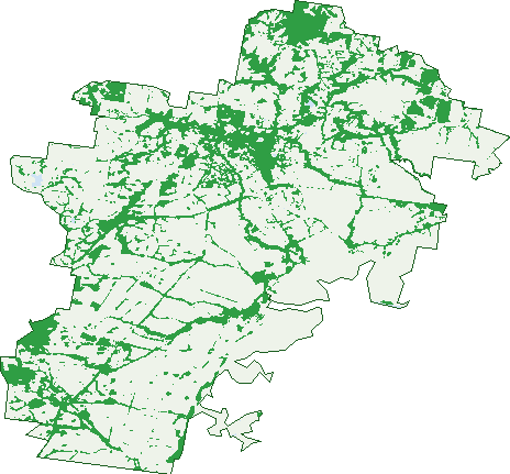
Green: 10 m cells where trees dominate, satellite 2021. Blue: water. The line is the suburb boundary.
| Canopy share, 1 m canopy height map, 2020 | 16.4% |
|---|---|
| Land with trees, 10 m satellite map, 2021 | 24.5% |
Demographics
Unemployment 3.6% · Labour-force participation 42.6%
Population by age in Foster
| 0-4 | 59 |
|---|---|
| 5-14 | 181 |
| 15-19 | 87 |
| 20-24 | 62 |
| 25-34 | 125 |
| 35-44 | 155 |
| 45-54 | 211 |
| 55-64 | 349 |
| 65-74 | 406 |
| 75-84 | 274 |
| 85+ | 132 |
Dwelling types in Foster
| House | 784 |
|---|---|
| Townhouse | 30 |
| Apartment | 61 |
| Other | 13 |
Households by weekly income in Foster
| <$650 | 270 |
|---|---|
| $650-1,499 | 287 |
| $1,500-2,999 | 187 |
| $3,000+ | 87 |
Top ancestries in Foster
| English | 861 |
|---|---|
| Australian | 786 |
| Irish | 267 |
| Scottish | 250 |
| Ancestry NS | 196 |
| Other | 88 |
Housing tenure in Foster
| Owned | 493 |
|---|---|
| Mortgage | 174 |
| Rented | 176 |
| Other | 29 |
Cars per household in Foster
| 0 | 47 |
|---|---|
| 1 | 373 |
| 2 | 284 |
| 3 | 101 |
| 4+ | 69 |
Commute to work in Foster
| Car | 448 |
|---|---|
| Train | 0 |
| Bus | 0 |
| Tram/ferry | 0 |
| Walked | 65 |
| Bicycle | 6 |
| Home | 111 |
Top countries of birth in Foster
| England | 87 |
|---|---|
| New Zealand | 22 |
| Italy | 17 |
| Philippines | 15 |
| Scotland | 15 |
| India | 12 |
Languages used at home in Foster
| Italian | 12 |
|---|---|
| Tagalog | 8 |
| Spanish | 8 |
| Punjabi | 7 |
| Mandarin | 5 |
| French | 5 |
Birds & Wildlife Nearby
6,566 bird observations recorded near Foster — most often seen:
- Eurasian Blackbird (429)
- Australian Magpie (415)
- Superb Fairy-wren (377)
- Grey Fantail (330)
- Common Starling (329)
- Red Wattlebird (278)
- Little Wattlebird (261)
- Grey Shrike-thrush (245)
- Little Raven (239)
- Crimson Rosella (227)
- Laughing Kookaburra (227)
- Welcome Swallow (225)
- Eastern Spinebill (222)
Show all 30 birds recorded near Foster
- Brown Thornbill (220)
- House Sparrow (213)
- Eastern Rosella (209)
- Common Myna (203)
- Magpie-lark (185)
- Australian Wood Duck (181)
- White-browed Scrubwren (181)
- Pied Currawong (153)
- Grey Butcherbird (150)
- Eastern Yellow Robin (143)
- Galah (139)
- Little Corella (139)
- Southern Victoria Australian Magpie (137)
- Striated Thornbill (135)
- Pacific Black Duck (132)
- White-faced Heron (130)
- Australian Raven (112)
Sightings reported by observers, not a survey, so the counts show what people record rather than what lives here. Source: Atlas of Living Australia.
Nearby Suburbs
The closest suburbs to Foster:
- Bennison (5.9 km)
- Foster North (5.9 km)
- Port Franklin (7.1 km)
- Woorarra West (7.4 km)
- Wonga (7.6 km)
- Boolarong (10.3 km)
- Toora (10.5 km)
- Mount Best (11.2 km)
Embed this suburb
Add this free Foster stat card to your own site — just copy the code:
Preview:
Cite this page
Quoting these figures? Copy the credit line:
Keep an eye on Foster
One email when this data meaningfully changes — new census figures, prices, rankings. No spam, unsubscribe anytime.
Streets
- Acacia Drive (3)
- Albert Court (6)
- Allan Court (4)
- Ameys Track (56)
- Ameys Track Road (1)
- Anderson Road (5)
- Apex Court (15)
- Arnups Road (6)
- Astburys Road (2)
- Banksia Rise (4)
- Beach Road (2)
- Berry Street (7)
- Black Swamp Road (8)
- Blackwood Drive (25)
- Blundens Road (3)
- Boolarra-foster Road (17)
- Boundary Road (7)
- Boyd Court (9)
- Bridge Street (8)
- Bruce Court (11)
- Byrnes Street (3)
- Campbells Road (1)
- Cargeegs Road (3)
- Cayzer Road (7)
- Charity Lane (6)
- Charles Street (6)
- Church Hill Road (13)
- Clement Court (14)
- Collis Street (25)
- Coopers Road (24)
- Court Street (9)
- Davis Road (16)
- Dessents Road (1)
- Devlin Road (38)
- Durston Road (3)
- Dyrings Road (3)
- Elphicks Road (9)
- Fish Creek-foster Road (67)
- Fleet Street (5)
- Fleming Road (2)
- Forest Rise (8)
- Foster Beach Road (5)
- Foster-mt Best Road (14)
- Foster-promontory Road (41)
- Frances Court (2)
- Fullers Road (66)
- Gardiners Road (40)
- Gibbs Street (19)
- Grevillea Crescent (9)
- Hall Road (24)
- Harmon Road (21)
- Heath Rise (8)
- Hobsons Road (7)
- Hoddle Road (28)
- Hyland Street (12)
- Jacksons Road (7)
- Jay Road (25)
- Jones Street (5)
- Kaffir Hill Road (11)
- Landing Road (9)
- Landy Road (25)
- Law Road (2)
- Lawrence Road (1)
- Lays Road (2)
- Leighton Road (2)
- Linton Court (43)
- Linton Road (12)
- Lower Franklin Road (52)
- Main Street (86)
- Maines Way (4)
- Mcclure Lane (4)
- Mcdonald Street (33)
- Mcdonald Street E (11)
- Mcdonalds Street E (1)
- Mcgleads Road (10)
- Mckenzie Place (20)
- Mcmaster Court (13)
- Mine Road (14)
- Nelson Street (45)
- Nippards Track (1)
- Oberon Vista (14)
- Oconnell Road (23)
- Odeas Lane (1)
- Ogradys Ridge Road (29)
- Old Hat Road (7)
- Oram Road (3)
- Parkside Crescent (28)
- Perkins Road (1)
- Pioneer Street (76)
- Port Franklin Road (2)
- Pound Road (6)
- Powells Road (13)
- Power Street (5)
- Reserve Street (10)
- Reservoir Road E (1)
- Reservoir Street (2)
- Rice Street (1)
- Richards Court (4)
- Sherry Street (8)
- Simpson Street (23)
- South Gippsland Highway (65)
- Sparkes Court (10)
- Stapleton Road (2)
- Station Road (118)
- Toora Road (26)
- Toto Court (4)
- Varney Road (25)
- Victory Avenue (60)
- Williams Drive (4)
- Wilson Road (4)
- Winchester Street (26)
- Wood Court (8)
- Wood Road (27)
- Yellow Brick Road (3)