Flamingo Beach VIC 3851
1,075 addresses · 48 streets
Gippsland Electorate › Wellington LGA › Flamingo Beach · 212 km from Melbourne
📦 Thinking of moving here? Read the Flamingo Beach moving guide

Getting Around & Local Services
1 beach
Getting around. Airport: West Sale Airport, 36.6 km north-west.
Tree cover
🌳 Tree canopy: 23.7% share of land under canopy · satellite map, 2020
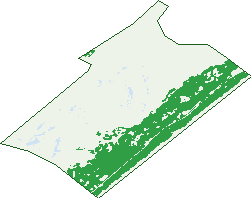
Green: 10 m cells where trees dominate, satellite 2021. Blue: water. The line is the suburb boundary.
| Canopy share, 1 m canopy height map, 2020 | 23.7% |
|---|---|
| Land with trees, 10 m satellite map, 2021 | 28.1% |
Birds & Wildlife Nearby
471 bird observations recorded near Flamingo Beach — most often seen:
- Superb Fairy-wren (32)
- Crimson Rosella (23)
- Red Wattlebird (23)
- Australian Magpie (21)
- Masked Lapwing (20)
- Black Swan (19)
- Little Raven (19)
- Little Wattlebird (19)
- Grey Fantail (18)
- Chestnut Teal (17)
- White-browed Scrubwren (17)
- Grey Teal (16)
- Silver Gull (16)
Show all 30 birds recorded near Flamingo Beach
- Australian Shelduck (15)
- White-faced Heron (15)
- Willie Wagtail (14)
- Brown Thornbill (13)
- Grey Currawong (13)
- Grey Shrike-thrush (13)
- Silvereye (13)
- Welcome Swallow (13)
- Eastern Yellow Robin (12)
- Magpie-lark (12)
- Pacific Black Duck (12)
- Pacific Gull (12)
- Common Bronzewing (11)
- Crested Tern (11)
- Eastern Rosella (11)
- Whistling Kite (11)
- Eurasian Coot (10)
Sightings reported by observers, not a survey, so the counts show what people record rather than what lives here. Source: Atlas of Living Australia.
Nearby Suburbs
The closest suburbs to Flamingo Beach:
- Glomar Beach (3 km)
- Golden Beach (6.6 km)
- Dutson Downs (11.1 km)
- The Honeysuckles (11.3 km)
- Paradise Beach (13.1 km)
- Dutson (14.8 km)
- Seaspray (15.5 km)
- Seacombe (19.8 km)
Embed this suburb
Add this free Flamingo Beach stat card to your own site — just copy the code:
Preview:
Cite this page
Quoting these figures? Copy the credit line:
Keep an eye on Flamingo Beach
One email when this data meaningfully changes — new census figures, prices, rankings. No spam, unsubscribe anytime.
Streets
- Amarillo Way (36)
- Amigo Court (11)
- Ascunsion Way (20)
- Avocado Avenue (14)
- Belmonte Way (13)
- Bogota Drive (26)
- Calama Court (5)
- Calao Court (9)
- Calio Court (11)
- Campania Way (26)
- Canastra Way (20)
- Caravellas Way (23)
- Catamarca Court (5)
- Cisco Way (3)
- Corsica Court (14)
- Flamingo Drive (106)
- Gallapogos Way (20)
- Lima Way (4)
- Mirrabella Drive (6)
- Palma Way (5)
- Quito Way (6)
- San Antonio Drive (21)
- San Domingo Avenue (21)
- San Fernando Way (16)
- San Flores Way (24)
- San Gemini Avenue (34)
- San Jose Drive (57)
- San Julian Way (24)
- San Luis Drive (11)
- San Michelle Avenue (25)
- San Montego Avenue (22)
- San Nicola Drive (18)
- San Paulo Crescent (34)
- San Pedro Way (14)
- San Porto Way (13)
- San Rafael Drive (24)
- San Real Avenue (18)
- San Remo Drive (15)
- San Salvadore Drive (15)
- Santa Cruz Avenue (24)
- Santa Maria Way (26)
- Santa Rosa Avenue (22)
- Santa Ventura Drive (26)
- Santiago Drive (30)
- Santos Way (12)
- Shoreline Drive (102)
- Talara Avenue (27)
- Valvida Way (17)