Donvale VIC 3111
6,010 addresses · 206 streets
Menzies Electorate › Manningham LGA › Donvale · 20 km from Melbourne
📦 Thinking of moving here? Read the Donvale moving guide

Living Here
Donvale is a suburb of Victoria, home to about 12,644 people, with a median age of 45. The typical household earns around $2,100 a week, with median rent near $450 a week. Most homes are houses. About 81% of households own their home and 16% rent. Most workers drive to work. Common community backgrounds include English, Australian, Chinese. On the ABS socio-economic scale it sits in decile 10 of 10 nationally — a relatively advantaged area. The median house sells for about $1,514,000.
Over time — Census 2001 → 2021
Dashed line: district figures for the Donvale - Park Orchards statistical area (SA2), the smallest area the ABS published before 2011. Solid line: Donvale itself.
Getting Around & Local Services
3 physiotherapists
3 bakeries
3 beauty salons
3 carpenters
Getting around. Train station: Mitcham, 3 km south · Railway halt: Box Hill, 6 km west · Bus interchange: Ringwood Station/Maroondah Hwy, 4.8 km south-east · Airport: Moorabbin Airport, 22.1 km south.
Sport & Recreation
4 facilities recorded in Donvale.
- Buck Reserve Equestrian
- Donvale Reserve Australian Rules Football, Basketball, Cricket, Netball, Soccer, Tennis (Outdoor)
- Hillcrest Tennis Club Tennis (Outdoor)
- Manningham Donvale Indoor Sports Centre Badminton, Basketball, Netball (Indoor), Table Tennis, Volleyball
Socio-economic Standing
Deciles from 1 (lowest) to 10 (highest), against all Australian suburbs. The overall figure weighs advantage and disadvantage together; economic resources counts income and housing, and education & jobs counts qualifications and occupation. They often differ. Source: ABS SEIFA 2021.
Median Sale Prices
Median of recorded sales in the period, not a valuation. Source: Victorian Property Sales Report, Land Use Victoria.
Tree cover
🌳 Tree canopy: 32.3% share of land under canopy · satellite map, 2020
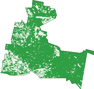
Green: 10 m cells where trees dominate, satellite 2021. Blue: water. The line is the suburb boundary.
| Canopy share, 1 m canopy height map, 2020 | 32.3% |
|---|---|
| Land with trees, 10 m satellite map, 2021 | 83.0% |
Demographics
Unemployment 4.9% · Labour-force participation 59.3%
Population by age in Donvale
| 0-4 | 527 |
|---|---|
| 5-14 | 1,552 |
| 15-19 | 805 |
| 20-24 | 728 |
| 25-34 | 1,059 |
| 35-44 | 1,526 |
| 45-54 | 1,816 |
| 55-64 | 1,648 |
| 65-74 | 1,357 |
| 75-84 | 1,040 |
| 85+ | 584 |
Dwelling types in Donvale
| House | 3,749 |
|---|---|
| Townhouse | 444 |
| Apartment | 128 |
| Other | 0 |
Households by weekly income in Donvale
| <$650 | 597 |
|---|---|
| $650-1,499 | 903 |
| $1,500-2,999 | 1,110 |
| $3,000+ | 1,441 |
Top ancestries in Donvale
| English | 3,105 |
|---|---|
| Australian | 2,757 |
| Chinese | 2,647 |
| Other | 1,693 |
| Italian | 1,130 |
| Irish | 904 |
Housing tenure in Donvale
| Owned | 1,881 |
|---|---|
| Mortgage | 1,581 |
| Rented | 666 |
| Other | 126 |
Cars per household in Donvale
| 0 | 141 |
|---|---|
| 1 | 1,220 |
| 2 | 1,850 |
| 3 | 651 |
| 4+ | 417 |
Commute to work in Donvale
| Car | 2,872 |
|---|---|
| Train | 46 |
| Bus | 57 |
| Tram/ferry | 0 |
| Walked | 22 |
| Bicycle | 6 |
| Home | 2,064 |
Top countries of birth in Donvale
| China | 951 |
|---|---|
| Hong Kong | 390 |
| Malaysia | 388 |
| England | 284 |
| Iran | 235 |
| India | 230 |
Languages used at home in Donvale
| Mandarin | 1,121 |
|---|---|
| Cantonese | 966 |
| Greek | 364 |
| Italian | 301 |
| Persian | 259 |
| Arabic | 205 |
Birds & Wildlife Nearby
118,836 bird observations recorded near Donvale — most often seen:
- Little Raven (6,968)
- Rainbow Lorikeet (6,684)
- Noisy Miner (6,260)
- Australian Magpie (6,188)
- Southern Victoria Australian Magpie (5,275)
- Pacific Black Duck (5,227)
- Red Wattlebird (5,148)
- Spotted Turtle-dove (4,800)
- Common Myna (4,614)
- Tawny Frogmouth (4,378)
- Laughing Kookaburra (4,182)
- Grey Butcherbird (4,132)
- Eastern Rainbow Lorikeet (4,016)
Show all 30 birds recorded near Donvale
- Pied Currawong (3,923)
- Dusky Moorhen (3,718)
- Brown Thornbill (3,641)
- Magpie-lark (3,448)
- Australian Wood Duck (3,430)
- Common Bronzewing (3,382)
- Superb Fairy-wren (3,090)
- Eastern Rosella (3,076)
- Eurasian Blackbird (3,038)
- Grey Fantail (2,656)
- Galah (2,614)
- Eastern Red Wattlebird (2,598)
- Southern Noisy Miner (2,569)
- Spotted Pardalote (2,538)
- Eurasian Coot (2,491)
- Chestnut Teal (2,386)
- White-browed Scrubwren (2,366)
Sightings reported by observers, not a survey, so the counts show what people record rather than what lives here. Source: Atlas of Living Australia.
Nearby Suburbs
The closest suburbs to Donvale:
- Doncaster East (2.2 km)
- Nunawading (3.1 km)
- Blackburn North (3.1 km)
- Park Orchards (3.1 km)
- Mitcham (3.2 km)
- Ringwood North (4.1 km)
- Blackburn (4.4 km)
- Ringwood (4.7 km)
Embed this suburb
Add this free Donvale stat card to your own site — just copy the code:
Preview:
Cite this page
Quoting these figures? Copy the credit line:
Keep an eye on Donvale
One email when this data meaningfully changes — new census figures, prices, rankings. No spam, unsubscribe anytime.
Streets
- Adelyn Avenue (22)
- Akoonah Close (19)
- Allara Court (12)
- Allinga Place (6)
- Amys Grove (16)
- Ananda Court (10)
- Anglemere Crescent (13)
- Aquarius Court (14)
- Aranga Crescent (55)
- Argyle Street (55)
- Arnold Drive (16)
- Ash Court (5)
- Astelot Drive (58)
- Balcombe Court (11)
- Baradine Terrace (24)
- Barwon Court (10)
- Bayles Court (9)
- Beckett Road (46)
- Bellevue Avenue (1)
- Belmont Court (10)
- Ben Court (9)
- Bernarra Court (9)
- Berrima Road (58)
- Braham Street (14)
- Brushtail Court (7)
- Bullock Court (16)
- Bursaria Rise (22)
- Cabena Street (14)
- Cameron Close (21)
- Carbine Street (75)
- Cat Jump Road (6)
- Cerberus Street (43)
- Chaim Court (16)
- Charlwood Court (5)
- Cherry Grove (49)
- Chippewa Avenue (154)
- Clarice Court (8)
- Clements Avenue (10)
- Clery Avenue (7)
- Colwyn Court (12)
- Conder Street (1)
- Conos Court (16)
- Conway Avenue (10)
- Craig Road (34)
- Craileen Street (19)
- Cresthaven Court (11)
- Creswick Street (9)
- Daniel Street (18)
- Darvall Street (92)
- Decontra Close (6)
- Dellview Court (20)
- Dempster Court (13)
- Doncaster Road (33)
- Douglas Avenue (8)
- Drewe Close (9)
- Drummond Close (8)
- Dwyer Court (18)
- Eastway Avenue (20)
- Edward Street (21)
- Elata Street (3)
- Eleanor Court (7)
- Elizabeth Court (15)
- Ellerton Court (16)
- Elliot Close (6)
- Empery Court (7)
- Epsom Court (6)
- Era Court (17)
- Eva Court (10)
- Exford Place (6)
- Fahey Place (7)
- Fink Court (5)
- Flora Road (14)
- Florence Avenue (69)
- Galovac Close (25)
- Garden Road (38)
- Glamis Street (1)
- Glenvale Road (86)
- Glenwood Close (10)
- Glika Street (32)
- Golden Wattle Ridge (8)
- Goodenia Loop (32)
- Greenview Close (14)
- Hamal Street (34)
- Harris Road (30)
- Heads Road (67)
- Hillcrest Court (21)
- Holly Green Close (10)
- Honybun Court (9)
- Hope Avenue (31)
- Huggins Road (8)
- Hunt Street (40)
- Huon Court (5)
- Ida Court (11)
- Illawong Drive (32)
- Jason Court (10)
- Jasper Place (13)
- Jilpanger Road (24)
- Jolen Court (21)
- Joy Street (2)
- Kalingur Court (10)
- Kern Place (2)
- Kevin Court (14)
- Kew Court (6)
- Knight Court (5)
- Kyreli Close (8)
- Langford Crescent (33)
- Larne Avenue (48)
- Leon Court (7)
- Leslie Street (177)
- Limassol Court (25)
- Linford Close (7)
- Lisbeth Avenue (103)
- Lookover Road (41)
- Lynne Street (60)
- Manna Bank View (11)
- Manor Court (11)
- Martha Street (54)
- Mcgowans Road (124)
- Melissa Street (86)
- Michellan Court (20)
- Miramar Court (16)
- Mitcham Road (483)
- Moana Place (6)
- Monterey Crescent (22)
- Mopoke Lane (7)
- Mozart Circle (12)
- Mullum Drive (11)
- Mulsanne Way (31)
- Murndal Drive (36)
- Niagara Road (29)
- Nightingale Close (20)
- Oban Road (46)
- Old Warrandyte Road (280)
- One Tree Hill (11)
- Opala Court (11)
- Oregon Drive (37)
- Pambara Court (7)
- Park Road (78)
- Parkhill Court (9)
- Parklands Close (25)
- Parkville Place (28)
- Pescara Place (9)
- Pictor Court (17)
- Pine Ridge (36)
- Pisces Court (17)
- Powers Street (50)
- Quamby Place (7)
- Rangeview Road (29)
- Remy Court (9)
- Reynolds Road (34)
- Rickson Place (7)
- Robdon Court (7)
- Robinson Court (4)
- Roslyn Court (3)
- Roy Street (91)
- Ruby Street (20)
- Ruth Street (13)
- Sanders Road (1)
- Sandra Court (11)
- Savaris Court (34)
- Selsdon Terrace (7)
- Serpells Terrace (45)
- Shirvington Place (21)
- Snow Gum Road (1)
- Solson Place (13)
- Sonia Street (56)
- Sowter Court (11)
- Springvale Road (323)
- Springwood Close (33)
- Standring Close (18)
- Stock Court (2)
- Stringers Rise (5)
- Sturdee Road (24)
- Sunray Court (20)
- Tadstan Place (12)
- Tallawarra Rise (8)
- Tandarook Crescent (22)
- The Elms (26)
- The Glen (34)
- Tindals Road (12)
- Trudi Court (5)
- Tunstall Road (150)
- Underwood Drive (22)
- Utrecht Court (6)
- Valepark Drive (75)
- Vasey Grove (19)
- Vaucluse Court (7)
- Vernon Street (5)
- Vistaway Court (21)
- Wallace Avenue (11)
- Warner Court (24)
- Warrock Avenue (10)
- Wattamolla Ridge (8)
- Wellwood Close (4)
- Wembley Gardens (52)
- White Lodge Court (21)
- Whitefriars Way (17)
- William Street (46)
- Wooddale Grove (55)
- Woodhall Wynd (28)
- Woodhouse Road (74)
- Woolerton Court (9)
- Wrendale Drive (27)
- Wright Avenue (9)
- Yileen Court (9)
- Young Street (12)