Creswick VIC 3363
2,316 addresses · 144 streets
Ballarat Electorate › Hepburn LGA › Creswick · 104 km from Melbourne
📦 Thinking of moving here? Read the Creswick moving guide

Living Here
Creswick is a suburb of Victoria, home to about 3,279 people, with a median age of 50. The typical household earns around $1,144 a week, with median rent near $275 a week. Most homes are houses. About 79% of households own their home and 19% rent. Most workers drive to work. Common community backgrounds include English, Australian, Irish. On the ABS socio-economic scale it sits in decile 3 of 10 nationally — a more disadvantaged area. The median house sells for about $515,000.
Over time — Census 2001 → 2021
Dashed line: district figures for the Creswick - Clunes statistical area (SA2), the smallest area the ABS published before 2011. Solid line: Creswick itself.
Getting Around & Local Services
5 cafés & restaurants
1 supermarket
1 Catholic church
1 post office
1 service station
2 gyms & sports centres
1 golf club
1 playground
1 butcher
1 carpenter
Getting around. Train station: Creswick, 250 m south-west.
Sport & Recreation
7 facilities recorded in Creswick.
- Calembeen Park Dive Tower Swimming
- Creswick Bowling Club Lawn Bowls
- Creswick Golf Club Golf
- Creswick Recreation Reserve Australian Rules Football, Cricket
- Creswick Skate Park Skating
- Doug Lindsay Recreation Reserve Australian Rules Football, Netball, Soccer
- Mount Prospect Tennis Tennis (Outdoor)
Socio-economic Standing
Deciles from 1 (lowest) to 10 (highest), against all Australian suburbs. The overall figure weighs advantage and disadvantage together; economic resources counts income and housing, and education & jobs counts qualifications and occupation. They often differ. Source: ABS SEIFA 2021.
Median Sale Prices
Median of recorded sales in the period, not a valuation. Source: Victorian Property Sales Report, Land Use Victoria.
Tree cover
🌳 Tree canopy: 49.6% share of land under canopy · satellite map, 2020
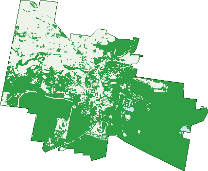
Green: 10 m cells where trees dominate, satellite 2021. Blue: water. The line is the suburb boundary.
| Canopy share, 1 m canopy height map, 2020 | 49.6% |
|---|---|
| Land with trees, 10 m satellite map, 2021 | 68.2% |
Demographics
Unemployment 4.8% · Labour-force participation 48.4%
Population by age in Creswick
| 0-4 | 166 |
|---|---|
| 5-14 | 340 |
| 15-19 | 154 |
| 20-24 | 114 |
| 25-34 | 288 |
| 35-44 | 332 |
| 45-54 | 440 |
| 55-64 | 491 |
| 65-74 | 514 |
| 75-84 | 302 |
| 85+ | 140 |
Dwelling types in Creswick
| House | 1,193 |
|---|---|
| Townhouse | 11 |
| Apartment | 89 |
| Other | 26 |
Households by weekly income in Creswick
| <$650 | 341 |
|---|---|
| $650-1,499 | 444 |
| $1,500-2,999 | 353 |
| $3,000+ | 111 |
Top ancestries in Creswick
| English | 1,385 |
|---|---|
| Australian | 1,260 |
| Irish | 490 |
| Scottish | 428 |
| Ancestry NS | 326 |
| German | 169 |
Housing tenure in Creswick
| Owned | 569 |
|---|---|
| Mortgage | 457 |
| Rented | 241 |
| Other | 32 |
Cars per household in Creswick
| 0 | 61 |
|---|---|
| 1 | 482 |
| 2 | 460 |
| 3 | 203 |
| 4+ | 99 |
Commute to work in Creswick
| Car | 851 |
|---|---|
| Train | 3 |
| Bus | 9 |
| Tram/ferry | 0 |
| Walked | 38 |
| Bicycle | 0 |
| Home | 173 |
Top countries of birth in Creswick
| England | 105 |
|---|---|
| Netherlands | 34 |
| New Zealand | 30 |
| Germany | 21 |
| Philippines | 12 |
| Ireland | 11 |
Languages used at home in Creswick
| Sinhalese | 10 |
|---|---|
| French | 9 |
| Italian | 8 |
| Tagalog | 8 |
| Serbian | 6 |
| German | 5 |
Birds & Wildlife Nearby
5,285 bird observations recorded near Creswick — most often seen:
- Eurasian Blackbird (287)
- Little Raven (273)
- Crimson Rosella (272)
- Australian Magpie (268)
- Superb Fairy-wren (264)
- Pacific Black Duck (244)
- Red Wattlebird (241)
- Grey Fantail (233)
- Australian Wood Duck (217)
- Brown Thornbill (208)
- Common Bronzewing (173)
- Yellow-faced Honeyeater (173)
- Little Pied Cormorant (168)
Show all 30 birds recorded near Creswick
- Laughing Kookaburra (163)
- Long-billed Corella (160)
- Galah (159)
- Southern Victoria Australian Magpie (151)
- Eurasian Coot (149)
- Grey Shrike-thrush (146)
- Common Starling (138)
- Grey Currawong (135)
- House Sparrow (128)
- White-naped Honeyeater (127)
- Sulphur-crested Cockatoo (124)
- White-throated Treecreeper (124)
- Striated Thornbill (120)
- White-browed Scrubwren (115)
- White-faced Heron (115)
- Magpie-lark (111)
- Northern Superb Fairy-wren (99)
Sightings reported by observers, not a survey, so the counts show what people record rather than what lives here. Source: Atlas of Living Australia.
Nearby Suburbs
The closest suburbs to Creswick:
- Smokeytown (3.6 km)
- Cabbage Tree (3.7 km)
- Springmount (4 km)
- Broomfield (4.3 km)
- Bald Hills (4.9 km)
- Creswick North (5.3 km)
- Sulky (5.6 km)
- Allendale (6.4 km)
Embed this suburb
Add this free Creswick stat card to your own site — just copy the code:
Preview:
Cite this page
Quoting these figures? Copy the credit line:
Keep an eye on Creswick
One email when this data meaningfully changes — new census figures, prices, rankings. No spam, unsubscribe anytime.
Streets
- Acacia Road (2)
- Albert Street (131)
- Alexander Court (6)
- Alfred Street (8)
- Amos Street (1)
- Andrew Street (6)
- Anne Street (5)
- Armstrong Street (32)
- Ascot-creswick Road (48)
- Augusta Drive (30)
- Australasia Drive (15)
- Ayres Street (50)
- Bald Hills Road (54)
- Ballarat Road (48)
- Barbys Road (12)
- Battery Crescent (4)
- Bell Street (20)
- Berry Mine Lane (6)
- Brawn Road (3)
- Brewing Lane (1)
- Bridge Street (24)
- Broomfield Road (11)
- Burke Street (13)
- Burnham Lane (2)
- Cabbage Tree Road (1)
- Caddy Drive (24)
- Cambridge Street (64)
- Camp Street (21)
- Carmody Drive (10)
- Carpenter Street (8)
- Cassels Lane (3)
- Castlemaine Road (16)
- Charles Street (6)
- Cheney Street (1)
- Church Street (27)
- Clifton Road (3)
- Clunes Road (144)
- Clunes-creswick Road (11)
- Condo Drive (2)
- Cooper Street (7)
- Creswick-bungaree Road (2)
- Creswick-dean Road (1)
- Creswick-newstead Road (6)
- Curtin Court (5)
- Curtis Street (7)
- Cushing Avenue (101)
- Davies Street (8)
- Davis Street (23)
- De Regt Drive (4)
- Deep Lead Lane (2)
- Drummond Street (26)
- Elizabeth Road (48)
- Ellis Road (4)
- Exchange Lane (12)
- Fisher Road (1)
- Fitzgerald Street (4)
- Ford Street (11)
- Forest Resort Midland Highway (7)
- Four Star Road (10)
- Frenchmans Road (4)
- Gardiner Street (24)
- Geddes Road (4)
- Gillies Road (22)
- Government Road (4)
- Haines Street (25)
- Hakea Street (2)
- Hall Street (9)
- Hammon Street (30)
- Harvey Street (16)
- Hepburn Court (14)
- Hickory Lane (16)
- Hickory Place (10)
- Hill Street (5)
- Hutchinson Street (10)
- Hyde Park Road (31)
- Johns Road (8)
- Jones Road (1)
- Jory Street (32)
- Kennedy Lane (3)
- King Street (30)
- Lakeside Drive (4)
- Lalor Lane (2)
- Lees Street (3)
- Lewers Street (18)
- Liddicoat Road (11)
- Lindsay Court (7)
- Lindsay Park Drive (4)
- Lionel Street (6)
- Little King Street (6)
- Luttet Street (64)
- Macs Street (30)
- Melbourne Road (64)
- Mendhams Dam Road (7)
- Midland Highway (50)
- Moore Street (54)
- Moores Road (1)
- Napier Street (52)
- North Parade (12)
- North Street (3)
- Nuggety Gully Road (5)
- Oaktree Lane (13)
- Orr Street (15)
- Oswin Drive (5)
- Parkes Road (2)
- Pasco Street (22)
- Pearman Street (1)
- Penny Lane (25)
- Phillip Street (22)
- Pollards Lane (14)
- Porter Street (1)
- Pound Lane (4)
- Prince Street (22)
- Quicks Lane (1)
- Raglan Street (24)
- Railway Parade (13)
- Red Streak Road (5)
- Reed Street (38)
- Richard Court (18)
- Rogers Street (14)
- Ryalls Street (1)
- Semmens Avenue (15)
- Short Street (3)
- Slaty Creek Road (2)
- South Street (11)
- Speargrass Crescent (14)
- Spittle Road (14)
- St Georges Lake Road (13)
- St Georges Street (3)
- Stevens Street (2)
- Tait Drive (17)
- Temple Road (1)
- The Board Walk (5)
- Townsend Road (8)
- Turner Street (3)
- Victoria Street (28)
- Voigts Street (3)
- Water Street (6)
- Webb Street (1)
- White Hills Road (11)
- White Street (4)
- Wild Orchid Road (4)
- Williams Street (8)
- Wills Street (2)
- Wright Court (13)