Cranbourne East VIC 3977
10,435 addresses · 432 streets
Holt Electorate › Casey LGA › Cranbourne East · 45 km from Melbourne
📦 Thinking of moving here? Read the Cranbourne East moving guide

Living Here
A fast-growing outer-south-eastern Melbourne suburb of new family estates, Cranbourne East has a young median age of 31 and large households of 3.3 people. Median household income is $1,912 a week, with rent around $400.
Cranbourne East is a suburb of Victoria, home to about 24,679 people, with a median age of 31. The typical household earns around $1,912 a week, with median rent near $400 a week. Most homes are houses. About 72% of households own their home and 24% rent. Most workers drive to work. Common community backgrounds include English, Australian, Indian. On the ABS socio-economic scale it sits in decile 5 of 10 nationally — a mid-range area. The median house sells for about $720,000.
Over time — Census 2001 → 2021
Dashed line: district figures for the Cranbourne East statistical area (SA2), the smallest area the ABS published before 2011. Solid line: Cranbourne East itself.
Getting Around & Local Services
29 schools
- Marnebek School New Holland Drive Campus
- Cranbourne East Primary School
- Casey Grammar School
- Cranbourne East Secondary College
- Casey Fields Primary School
- Marnebek School Corrigans Road Campus
- St Thomas the Apostle Catholic Primary School
- Cranbourne Primary School
- St Peter's College Clyde North Campus
- Wilandra Rise Primary School
1 physiotherapist
1 optometrist
1 library
2 post offices
1 playground
4 hardware stores
1 plumber
1 place to stay
Getting around. Train station: Cranbourne, 2.5 km north-west · Bus interchange: The Explorer, 3.5 km south-west · Airport: Moorabbin Airport, 23.3 km north-west.
Sport & Recreation
7 facilities recorded in Cranbourne East.
- Blue Hills Bowling Club Lawn Bowls
- Casey Fields Athletics, Australian Rules Football, Cricket, Cycling, Netball, Rugby League, Rugby Union, Tennis (Outdoor)
- Casey Fields Cycling
- Casey Indoor Leisure Centre AFL (Indoor), Basketball, Beach Volleyball, Netball, Soccer (Indoor Soccer / Futsal), Tennis (Indoor), Volleyball
- Casey Indoor Leisure Centre Basketball, Netball
- Casey Race Swimming
- Hunt Club Estate Australian Rules Football, Cricket
Socio-economic Standing
Deciles from 1 (lowest) to 10 (highest), against all Australian suburbs. The overall figure weighs advantage and disadvantage together; economic resources counts income and housing, and education & jobs counts qualifications and occupation. They often differ. Source: ABS SEIFA 2021.
Median Sale Prices
Median of recorded sales in the period, not a valuation. Source: Victorian Property Sales Report, Land Use Victoria.
Tree cover
🌳 Tree canopy: 6.5% share of land under canopy · satellite map, 2020
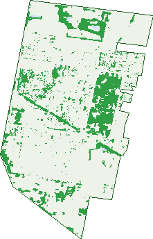
Green: 10 m cells where trees dominate, satellite 2021. Blue: water. The line is the suburb boundary.
| Canopy share, 1 m canopy height map, 2020 | 6.5% |
|---|---|
| Land with trees, 10 m satellite map, 2021 | 15.7% |
Demographics
Unemployment 5.6% · Labour-force participation 65.4%
Population by age in Cranbourne East
| 0-4 | 2,325 |
|---|---|
| 5-14 | 4,407 |
| 15-19 | 1,624 |
| 20-24 | 1,579 |
| 25-34 | 3,792 |
| 35-44 | 4,756 |
| 45-54 | 2,480 |
| 55-64 | 1,382 |
| 65-74 | 1,096 |
| 75-84 | 852 |
| 85+ | 390 |
Dwelling types in Cranbourne East
| House | 6,355 |
|---|---|
| Townhouse | 786 |
| Apartment | 29 |
| Other | 0 |
Households by weekly income in Cranbourne East
| <$650 | 712 |
|---|---|
| $650-1,499 | 1,750 |
| $1,500-2,999 | 3,024 |
| $3,000+ | 1,194 |
Top ancestries in Cranbourne East
| Other | 7,815 |
|---|---|
| English | 4,980 |
| Australian | 4,933 |
| Indian | 4,000 |
| Ancestry NS | 1,340 |
| Filipino | 1,208 |
Housing tenure in Cranbourne East
| Owned | 1,086 |
|---|---|
| Mortgage | 4,033 |
| Rented | 1,667 |
| Other | 280 |
Cars per household in Cranbourne East
| 0 | 195 |
|---|---|
| 1 | 2,163 |
| 2 | 3,301 |
| 3 | 985 |
| 4+ | 438 |
Commute to work in Cranbourne East
| Car | 7,507 |
|---|---|
| Train | 181 |
| Bus | 63 |
| Tram/ferry | 4 |
| Walked | 53 |
| Bicycle | 14 |
| Home | 1,599 |
Top countries of birth in Cranbourne East
| India | 4,094 |
|---|---|
| Philippines | 962 |
| Afghanistan | 961 |
| Sri Lanka | 729 |
| New Zealand | 719 |
| England | 535 |
Languages used at home in Cranbourne East
| Punjabi | 2,728 |
|---|---|
| Malayalam | 669 |
| Hindi | 657 |
| Sinhalese | 620 |
| Gujarati | 550 |
| Tamil | 449 |
Birds & Wildlife Nearby
89,225 bird observations recorded near Cranbourne East — most often seen:
- Superb Fairy-wren (5,892)
- Common Myna (4,728)
- Little Raven (4,692)
- Eurasian Blackbird (3,882)
- Pacific Black Duck (3,814)
- Common Bronzewing (3,597)
- White-browed Scrubwren (3,523)
- Northern Superb Fairy-wren (3,194)
- Red Wattlebird (3,095)
- New Holland Honeyeater (3,013)
- White-naped Honeyeater (2,857)
- Australasian Purple Swamphen (2,850)
- Tasmanian Grey Fantail (2,835)
Show all 30 birds recorded near Cranbourne East
- Eastern Red Wattlebird (2,681)
- Grey Fantail (2,642)
- Common Starling (2,623)
- South-eastern Brown Thornbill (2,614)
- Grey Shrike-thrush (2,584)
- Eurasian Coot (2,569)
- Eastern New Holland Honeyeater (2,565)
- Coastal Spotted Pardalote (2,518)
- Magpie-lark (2,373)
- South-eastern White-browed Scrubwren (2,368)
- South-eastern Yellow-faced Honeyeater (2,335)
- Brown Thornbill (2,297)
- Eastern Grey Shrike-thrush (2,258)
- Welcome Swallow (2,252)
- Spotted Pardalote (2,219)
- White-eared Honeyeater (2,189)
- South-eastern White-eared Honeyeater (2,166)
Sightings reported by observers, not a survey, so the counts show what people record rather than what lives here. Source: Atlas of Living Australia.
Nearby Suburbs
The closest suburbs to Cranbourne East:
- Cranbourne (2.6 km)
- Junction Village (2.8 km)
- Cranbourne North (3.9 km)
- Clyde (4.3 km)
- Botanic Ridge (4.5 km)
- Clyde North (4.7 km)
- Cranbourne West (4.8 km)
- Devon Meadows (5.6 km)
Embed this suburb
Add this free Cranbourne East stat card to your own site — just copy the code:
Preview:
Cite this page
Quoting these figures? Copy the credit line:
Keep an eye on Cranbourne East
One email when this data meaningfully changes — new census figures, prices, rankings. No spam, unsubscribe anytime.
Streets
- Aayana Street (58)
- Adrian Street (51)
- Affleck Street (40)
- Albion Park Drive (30)
- Alderstone Rise (15)
- All Spice Way (8)
- Almondbank Road (25)
- Andy Lane (8)
- Anice Street (6)
- Annabella Street (270)
- Annaleise Court (16)
- Aquitane Drive (15)
- Archers Field Drive (40)
- Ardent Crescent (46)
- Armoy Close (13)
- Armstrong Street (20)
- Arrow Road (27)
- Artemis Drive (66)
- Artfield Street (43)
- Aston Glade (7)
- Avalon Crescent (22)
- Aveley Place (7)
- Bales Road (33)
- Ballarto Road (33)
- Ballymena Crescent (23)
- Bandit Grove (6)
- Bankton Avenue (20)
- Baranello Avenue (22)
- Baranello Crescent (22)
- Barham Way (7)
- Barnby Grove (12)
- Barter Crescent (12)
- Basset Street (13)
- Bathgate Crescent (34)
- Beagle Street (31)
- Beatham Way (21)
- Beauchamp Way (10)
- Bellsquarry Avenue (20)
- Ben Hall Street (18)
- Benedetto Crescent (33)
- Berwick-cranbourne Road (65)
- Bichon Walk (9)
- Biferno Crescent (18)
- Bilongen Road (30)
- Birdwell Drive (14)
- Birmingham Road (41)
- Black Caesar Drive (19)
- Blackledge Drive (30)
- Bloodstone Way (17)
- Blue Bush Way (9)
- Blue Grass Court (16)
- Blue Hills Drive (31)
- Bolero Way (8)
- Bollington Road (4)
- Bonnell Grove (5)
- Boonwurrung Street (43)
- Bosc Street (19)
- Botany Way (54)
- Bourbon Road (89)
- Bowyer Avenue (18)
- Bradford Drive (73)
- Bradshaw Way (5)
- Briarcrest Drive (32)
- Brindalee Place (16)
- Briscola Street (4)
- Brittle Gum Road (40)
- Broad Oak Drive (51)
- Brockman Street (6)
- Buick Court (7)
- Burchill Avenue (37)
- Bushranger Boulevarde (30)
- Butterfield Place (18)
- Butterwick Terrace (13)
- Cadillac Street (27)
- Caliche Place (17)
- Camaro Drive (35)
- Cambridge Close (17)
- Cameron Street (223)
- Camilla Circuit (32)
- Canmore Street (35)
- Canopy Grove (21)
- Cardiff Grove (14)
- Carnavon Street (19)
- Cartwright Grove (17)
- Casey Fields Boulevard (64)
- Cedarbank Court (14)
- Celtic Drive (23)
- Challenger Circuit (60)
- Chamberlain Street (5)
- Chancery Lane (14)
- Chapelton Road (2)
- Charger Lane (5)
- Chatham Close (23)
- Cheddington Road (39)
- Chevrolet Road (31)
- Chief Court (7)
- Chorus Way (23)
- Cinnamon Drive (29)
- Clapton Court (7)
- Clarence Place (15)
- Clarkson Boulevard (55)
- Cloverbank Drive (16)
- Club House Crescent (14)
- Cobain Way (5)
- Cobalt Lane (4)
- Colachise Place (5)
- Collison Road (51)
- Comice Road (16)
- Connor Mews (11)
- Corgi Street (1)
- Cornwell Crescent (50)
- Corrigans Road (21)
- Cortula Road (47)
- Corvette Avenue (19)
- Coven Heath (7)
- Cranbourne Bypass (1)
- Criterion Way (52)
- Cromwell Lane (20)
- Cumin Way (8)
- Dalmatian Street (71)
- Dalton Way (15)
- Dan Morgan Drive (39)
- Dartmoor Drive (78)
- Dartnell Street (12)
- Dash Drive (33)
- Daws Street (10)
- Deegan Way (17)
- Detroit Avenue (20)
- Dewhurst Circuit (29)
- Diddley Close (13)
- Dodge Terrace (6)
- Donohue Street (46)
- Doriemus Street (16)
- Dream Avenue (31)
- Duce Street (39)
- Dunlavin Way (22)
- Dunstan Street (7)
- Easter Way (12)
- Eliburn Drive (65)
- Elmslie Drive (149)
- Emmer Green Retreat (27)
- Essex Court (11)
- Ethan Terrace (14)
- Evangeline Terrace (20)
- Explore Way (3)
- Ezra Street (50)
- Fable Way (36)
- Fairlane Court (11)
- Fernisky Drive (39)
- Fernside Close (3)
- Ferrari Drive (37)
- Fetlock Lane (23)
- Fiander Close (14)
- Fiorelli Boulevard (133)
- Firebird Street (18)
- Flash Dan Drive (35)
- Fluorite Street (13)
- Fouz Mews (10)
- Foxhound Grove (16)
- Foxwood Drive (33)
- Frankland Street (2)
- Fremantle Avenue (14)
- Gabitt Street (10)
- Gallop Close (10)
- Garden Street (14)
- Gareth Street (3)
- Gatehouse Parade (34)
- Gatwick Court (5)
- Gelding Close (11)
- Gemma Street (35)
- Genevieve Circuit (46)
- Godfrey Avenue (23)
- Goulburn Street (51)
- Grande Belmond Avenue (20)
- Granite Court (8)
- Greenaway Terrace (50)
- Greenglade Way (16)
- Greenock Crescent (23)
- Guineas Street (57)
- Gwenton Avenue (33)
- Haddington Way (5)
- Haflinger Avenue (28)
- Hailes Street (12)
- Haines Street (35)
- Hamer Way (5)
- Hammersmith Way (32)
- Hare Mews (9)
- Hargood Place (8)
- Haswell Street (15)
- Hateley Heath (10)
- Havlin Drive (9)
- Hawkeseye Way (17)
- Hawthorn Hedge Court (20)
- Headland Way (7)
- Heales Road (15)
- Heather Grove (33)
- Heathland Circuit (15)
- Hendrix Street (12)
- Hewitt Street (8)
- Hibernia Place (11)
- Hogan Street (10)
- Homebush Avenue (20)
- Horsham Drive (23)
- Houndsforth Street (15)
- Howden Street (11)
- Howe Way (17)
- Hunt Club Boulevard (43)
- Hutton Way (7)
- Hypnum Place (1)
- Ironstone Street (34)
- Ivanhoe Dene (4)
- Jagger Circuit (31)
- Jakara Street (6)
- Janice Terrace (4)
- Jeanetta Close (14)
- Jessfield Terrace (40)
- Jolly Street (28)
- Joplin Close (11)
- Josie Lane (5)
- Judith Place (4)
- Kells Close (16)
- Kelpie Street (14)
- Kemsley Green (8)
- Kennels Lane (7)
- Kinkade Close (13)
- Kirwan Drive (19)
- Lance Terrace (12)
- Langside Grove (20)
- Lanthorn Crescent (32)
- Launton Place (4)
- Leafy Circuit (26)
- Leak Avenue (3)
- Lehman Lane (2)
- Leni Street (6)
- Leongatha Court (5)
- Licodia Street (2)
- Limerick Road (10)
- Lineham Drive (124)
- Linsell Boulevard (106)
- Lockbank Place (4)
- Loddon Place (3)
- Louie Court (6)
- Macpherson Circuit (27)
- Maddie Court (16)
- Maddock Drive (28)
- Maeve Circuit (2)
- Maggie Street (15)
- Maiden Mews (10)
- Manor Court (15)
- Manuka Close (2)
- Mare Close (19)
- Marley Mews (9)
- Marngrook Avenue (2)
- Marrone Boulevard (34)
- Marshy Avenue (44)
- Masala Way (5)
- Maserati Way (10)
- Masterton Place (39)
- Mayfield Road (23)
- Mcallister Drive (32)
- Mccallum Drive (27)
- Mcewan Drive (63)
- Mcfarlan Way (5)
- Meadow Croft Court (11)
- Mercury Road (40)
- Meteorite Way (10)
- Midnight Rise (14)
- Monmouth Road (16)
- Moonlight Rise (6)
- Moonstone Crescent (16)
- Mopar Court (2)
- Morison Road (16)
- Mossbank Road (10)
- Mossey Crescent (53)
- Mossman Drive (27)
- Murrayfield Street (14)
- Napoleon Close (9)
- Narre Warren Road (22)
- Native Retreat (19)
- Navy Lane (4)
- Nebula Lane (14)
- Ned Street (13)
- Neilrex Court (13)
- Nellburn Terrace (11)
- Nelson Street (153)
- Nest Circuit (15)
- New Holland Drive (10)
- Newington Drive (15)
- Newmarket Street (15)
- Northumbria Street (22)
- Nugget Way (48)
- Oak Post Place (18)
- Ocean Street (10)
- Octagonal Street (36)
- Ogilvie Court (14)
- Ollie Place (29)
- Omeara Crescent (42)
- Otley Way (5)
- Otto Street (14)
- Pacific Drive (66)