Cowes VIC 3922
9,038 addresses · 288 streets
Monash Electorate › Bass Coast LGA › Cowes · 75 km from Melbourne
📦 Thinking of moving here? Read the Cowes moving guide

Living Here
The main town on Phillip Island, Cowes is a coastal holiday and retirement destination with an older, seasonal profile (median age 55). Households average 2.1 people. Median household income is $1,026 a week, with rent around $331.
Cowes is a suburb of Victoria, home to about 6,593 people, with a median age of 55. The typical household earns around $1,026 a week, with median rent near $331 a week. Most homes are houses. About 70% of households own their home and 27% rent. Most workers drive to work. Common community backgrounds include English, Australian, Scottish. On the ABS socio-economic scale it sits in decile 3 of 10 nationally — a more disadvantaged area. The median house sells for about $801,000.
Over time — Census 2001 → 2021
Dashed line: district figures for the Phillip Island statistical area (SA2), the smallest area the ABS published before 2011. Solid line: Cowes itself.
Getting Around & Local Services
4 supermarkets
1 Catholic church
2 pharmacies
1 medical clinic
1 physiotherapist
1 optometrist
1 hospital
1 vet
1 childcare centre
1 library
2 post offices
2 service stations
2 bakeries
1 butcher
2 hardware stores
4 hairdressers
2 beauty salons
1 plumber
Getting around. Train station: Stony Point, 9.2 km north · Ferry wharf: Cowes Jetty, 1.4 km north-east · Airport: Moorabbin Airport, 54.3 km north.
Sport & Recreation
9 facilities recorded in Cowes.
- Blue Gum Reserve Disk Golf
- Cowes Golf Club Golf
- Cowes Outdoor Pool Swimming
- Cowes Recreation Reserve Australian Rules Football, Cricket, Netball, Tennis (Outdoor)
- Cowes Skate Park Skating
- Cowes Yacht Club Sailing
- Phillip Island Bowling Club Lawn Bowls
- Phillip Island Croquet Club Croquet
- Phillip Island leisure Centre Basketball, Fitness / Gymnasium Workouts, Netball (Indoor), Squash / Racquetball
Socio-economic Standing
Deciles from 1 (lowest) to 10 (highest), against all Australian suburbs. The overall figure weighs advantage and disadvantage together; economic resources counts income and housing, and education & jobs counts qualifications and occupation. They often differ. Source: ABS SEIFA 2021.
Median Sale Prices
Median of recorded sales in the period, not a valuation. Source: Victorian Property Sales Report, Land Use Victoria.
Tree cover
🌳 Tree canopy: 14.9% share of land under canopy · satellite map, 2020
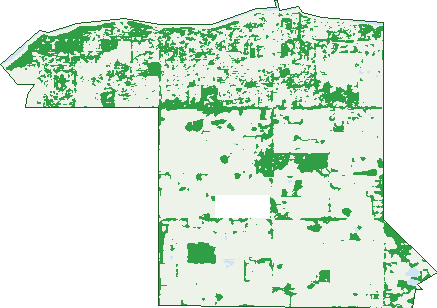
Green: 10 m cells where trees dominate, satellite 2021. Blue: water. The line is the suburb boundary.
| Canopy share, 1 m canopy height map, 2020 | 14.9% |
|---|---|
| Land with trees, 10 m satellite map, 2021 | 23.0% |
Demographics
Unemployment 4.4% · Labour-force participation 43.8%
Population by age in Cowes
| 0-4 | 275 |
|---|---|
| 5-14 | 659 |
| 15-19 | 237 |
| 20-24 | 182 |
| 25-34 | 529 |
| 35-44 | 630 |
| 45-54 | 732 |
| 55-64 | 1,036 |
| 65-74 | 1,305 |
| 75-84 | 710 |
| 85+ | 284 |
Dwelling types in Cowes
| House | 2,290 |
|---|---|
| Townhouse | 324 |
| Apartment | 111 |
| Other | 10 |
Households by weekly income in Cowes
| <$650 | 714 |
|---|---|
| $650-1,499 | 1,008 |
| $1,500-2,999 | 572 |
| $3,000+ | 254 |
Top ancestries in Cowes
| English | 2,868 |
|---|---|
| Australian | 2,347 |
| Scottish | 794 |
| Irish | 781 |
| Other | 420 |
| Ancestry NS | 407 |
Housing tenure in Cowes
| Owned | 1,272 |
|---|---|
| Mortgage | 606 |
| Rented | 727 |
| Other | 66 |
Cars per household in Cowes
| 0 | 155 |
|---|---|
| 1 | 1,207 |
| 2 | 981 |
| 3 | 242 |
| 4+ | 103 |
Commute to work in Cowes
| Car | 1,383 |
|---|---|
| Train | 0 |
| Bus | 5 |
| Tram/ferry | 0 |
| Walked | 113 |
| Bicycle | 31 |
| Home | 426 |
Top countries of birth in Cowes
| England | 425 |
|---|---|
| New Zealand | 108 |
| India | 77 |
| Italy | 61 |
| Scotland | 43 |
| Germany | 41 |
Languages used at home in Cowes
| Italian | 67 |
|---|---|
| Punjabi | 54 |
| Greek | 42 |
| Mandarin | 37 |
| Spanish | 34 |
| German | 26 |
Birds & Wildlife Nearby
46,731 bird observations recorded near Cowes — most often seen:
- Australasian Purple Swamphen (2,374)
- Australian White Ibis (2,249)
- Little Raven (2,244)
- Australian Magpie (2,181)
- Masked Lapwing (2,146)
- Red Wattlebird (2,096)
- Cape Barren Goose (2,004)
- Silver Gull (1,806)
- Eurasian Blackbird (1,791)
- Common Starling (1,714)
- Galah (1,616)
- Superb Fairy-wren (1,602)
- Black Swan (1,579)
Show all 30 birds recorded near Cowes
- Little Wattlebird (1,428)
- Australian Wood Duck (1,426)
- Rainbow Lorikeet (1,415)
- Laughing Kookaburra (1,408)
- Pacific Black Duck (1,390)
- Grey Fantail (1,387)
- Welcome Swallow (1,356)
- Brown Thornbill (1,254)
- Little Pied Cormorant (1,254)
- Eastern Rosella (1,235)
- Pacific Gull (1,187)
- Straw-necked Ibis (1,133)
- Grey Shrike-thrush (1,124)
- New Holland Honeyeater (1,090)
- Southern Victoria Australian Magpie (1,088)
- Willie Wagtail (1,080)
- Chestnut Teal (1,074)
Sightings reported by observers, not a survey, so the counts show what people record rather than what lives here. Source: Atlas of Living Australia.
Nearby Suburbs
The closest suburbs to Cowes:
- Wimbledon Heights (2.7 km)
- Silverleaves (3.1 km)
- Ventnor (4.4 km)
- Smiths Beach (5.4 km)
- Sunset Strip (5.4 km)
- Rhyll (6.2 km)
- Sunderland Bay (6.8 km)
- Surf Beach (7.8 km)
Embed this suburb
Add this free Cowes stat card to your own site — just copy the code:
Preview:
Cite this page
Quoting these figures? Copy the credit line:
Keep an eye on Cowes
One email when this data meaningfully changes — new census figures, prices, rankings. No spam, unsubscribe anytime.
Streets
- Abingdon Avenue (20)
- Acacia Close (6)
- Admiral Close (4)
- Albany Road (34)
- Albert Street (15)
- Alexander Avenue (44)
- Alpha Court (12)
- Amanda Close (7)
- Anderson Road (68)
- Angus Loop (49)
- Anthony Court (19)
- Appley Avenue (8)
- Atlantis Street (13)
- Austin Avenue (1)
- Back Beach Road (10)
- Baker Street (1)
- Bass Avenue (53)
- Bay Court (7)
- Bayliss Court (18)
- Bayview Drive (65)
- Beach Street (76)
- Bellavista Road (27)
- Benambra Court (11)
- Big Grey Mews (7)
- Birch Crescent (25)
- Birdwood Avenue (41)
- Blossom Road (14)
- Blue Gum Court (21)
- Blue Wren Place (3)
- Boardwalk Boulevard (42)
- Boobook Grove (31)
- Boonderabbi Way (30)
- Boronia Court (12)
- Bowerbird Crescent (17)
- Bradley Court (10)
- Broadwater Court (11)
- Bronzewing Drive (18)
- Broughton Avenue (32)
- Cadwell Street (2)
- Cape Barren Close (8)
- Carapooka Way (23)
- Carisbrooke Court (8)
- Caroline Avenue (18)
- Castle Combe Circuit (41)
- Casuarina Court (13)
- Chapel Street (261)
- Charissa Close (3)
- Charles Court (5)
- Charmandene Court (12)
- Chicory Avenue (12)
- Chillingworth Road (30)
- Chloe Close (10)
- Church Street (404)
- Churchill Drive (77)
- Clifton Crescent (25)
- Coastal Rise (4)
- Cockatoo Crescent (32)
- Coghlan Road (20)
- Coolalinga Court (4)
- Coramba Court (8)
- Cormorant Circuit (32)
- Cornwall Avenue (23)
- Cove Place (12)
- Cowes-rhyll Road (6)
- Crammond Road (6)
- Croft Close (1)
- Curlew Way (26)
- Currawong Close (17)
- Cuttlefish Place (3)
- Cypress Court (21)
- Dafydd Street (58)
- Darryl Court (11)
- Devon Avenue (20)
- Dianella Way (14)
- Dogwood Lane (2)
- Donington Circuit (1)
- Donington Way (1)
- Douglas Road (64)
- Driftwood Drive (31)
- Dunes Road (16)
- Dunsmore Road (82)
- Eagle Avenue (23)
- Echidna Grove (20)
- Egret Way (10)
- Elsford Close (8)
- Elvington Avenue (46)
- Emu Road (46)
- Endeavour Court (11)
- Eucalypt Close (9)
- Eva Lane (1)
- Everton Drive (52)
- Fairway Mews (5)
- Fields Court (1)
- Findlay Street (88)
- Firetail Grove (24)
- French Court (9)
- Gahnia Grove (7)
- Galah Street (14)
- Gap Road (14)
- Genesta Street (15)
- Glen Isla Court (16)
- Goodenia Place (6)
- Goodwood Drive (37)
- Goondiwindi Drive (21)
- Gordon Street (25)
- Grampian Boulevard (116)
- Grandview Grove (69)
- Grevilia Close (7)
- Hakea Court (10)
- Hana Court (6)
- Hanna Court (6)
- Hartley Street (29)
- Harvey Drive (19)
- Helen Street (20)
- Hereward Close (33)
- Highland Avenue (43)
- Hill Court (10)
- Hobsons Parade (63)
- Holiday Court (16)
- Hollydene Court (13)
- Homer Street (13)
- Hope Way (16)
- Hotham Close (19)
- Ibis Court (13)
- Ibsley Place (3)
- Industrial Way (28)
- Iona Court (13)
- Irving Road (33)
- Island Crescent (13)
- Ivy Leaf Close (4)
- James Street (7)
- Jenner Avenue (81)
- Jeury Court (24)
- Justice Road (93)
- Kangaroo Circuit (19)
- Kate Court (15)
- Katherine Circuit (75)
- Kauri Close (8)
- Kedah Road (30)
- Kembla Road (10)
- Kennon Court (3)
- Kenwyn Court (27)
- Kestrel Court (5)
- Killara Close (16)
- Kingfisher Way (13)
- Kirsten Close (3)
- Koala Street (41)
- Kookaburra Circuit (13)
- Kookaburra Way (12)
- Koonwarra Court (13)
- Langard Road (26)
- Lansell Road (38)
- Lapwing Street (26)
- Lawrence Avenue (19)
- Leeson Street (16)
- Leslie Avenue (69)
- Lions Court (111)
- Little Penguin Court (9)
- Lobelia Lane (5)
- Lomandra Drive (10)
- Longridge Street (8)
- Lorikeet Lane (10)
- Lynton Court (9)
- Malabar Court (6)
- Malay Street (11)
- Mallory Way (7)
- Manna Gum Drive (53)
- Market Close (19)
- Matthew Court (8)
- Maxwell Street (1)
- Mchaffie Drive (80)
- Mckenzie Road (136)
- Mclardy Court (15)
- Mcrae Avenue (32)
- Medina Road (17)
- Meldrum Court (8)
- Melissa Court (14)
- Millennium Way (5)
- Mitre Court (15)
- Monash Avenue (42)
- Monterey Avenue (17)
- Morgan Street (45)
- Nankeen Street (9)
- Norman Drive (57)
- Osbourne Avenue (63)
- Outlook Drive (35)
- Pardalote Place (8)
- Paringi Court (6)
- Park Street (32)
- Parkridge Close (6)
- Parrakoola Way (31)
- Parrot Street (22)
- Pasadena Drive (22)
- Pearl Court (15)
- Pembrey Circuit (56)
- Pembrey Loop (117)
- Penguin Avenue (11)
- Peninsula View (27)
- Perlis Avenue (13)
- Perry Avenue (6)
- Phillip Island Road (233)
- Phillip Street (16)
- Pine Avenue (37)
- Pinnacle Way (5)
- Platypus Crescent (20)
- Pleasant Road (12)
- Plover Street (60)
- Poa Place (8)
- Pobblebonk Place (6)
- Possum Place (5)
- Pyramid Rock Road (3)
- Raywood Avenue (33)
- Red Rocks Road (113)
- Redwood Drive (65)
- Rita Avenue (16)
- Robert Drive (27)
- Rockingham Close (3)
- Roderick Close (27)
- Rogan Close (12)
- Rose Avenue (43)
- Rosella Grove (21)
- Roy Court (17)
- Roydon Road (28)
- Rushmore Avenue (5)
- Ryan Court (7)
- Rylstone Road (10)
- Sanctuary Drive (25)
- Sandgate Rise (7)
- Sandpiper Circuit (21)
- Saraghi Place (12)
- Scenic Drive (112)
- Seacrest Drive (32)
- Seagrass Avenue (14)
- Seagrove Way (42)
- Seal Court (9)
- Seascape Avenue (35)
- Settlement Road (645)
- Seymour Place (6)
- Shamrock Avenue (39)
- Shelly Court (6)
- Shirley Court (6)
- Shoalhaven Road (22)
- Shorland Way (72)
- Signature Close (2)
- Silverstone Drive (12)
- Smiths Beach Road (22)
- Spaven Court (9)
- Spithead Street (1)
- St Georges Road (33)
- Steele Street (97)
- Stradbroke Avenue (43)
- Sunseeker Court (9)
- Sweet Bursaria Place (8)
- Talofa Avenue (19)
- Teddy Bear Lane (94)
- The Concourse (45)
- The Esplanade (192)
- The Gap Road (3)
- Thompson Avenue (328)
- Thruxton Street (18)
- Ti Tree Drive (33)
- Toscana Rise (10)
- Turnstone Place (4)
- Uringah Court (19)
- Vaughan Street (33)
- Ventnor Beach Road (7)
- Ventnor Road (61)
- Victoria Court (5)
- Von Mueller Way (1)
- Wagtail Way (28)
- Waldorf Road (14)
- Wallaby Grove (18)
- Walpole Street (28)
- Walton Street (131)
- Waratah Close (17)
- Warley Avenue (62)
- Watchorn Road (42)
- Water View Rise (21)
- Waterford Drive (19)
- Wattle Close (8)
- Wattlebird Close (4)
- West Court (15)
- Whimbrel Way (14)
- Wolfenden Street (1)
- Wonga Lane (20)
- Wren Loop (19)
- Wyndham Avenue (98)
- Yarramundi Way (31)