Cohuna VIC 3568
1,690 addresses · 90 streets
Mallee Electorate › Gannawarra LGA › Cohuna · 233 km from Melbourne
📦 Thinking of moving here? Read the Cohuna moving guide

Living Here
Cohuna is a suburb of Victoria, home to about 2,415 people, with a median age of 55. The typical household earns around $1,112 a week, with median rent near $185 a week. Most homes are houses. About 79% of households own their home and 18% rent. Most workers drive to work. Common community backgrounds include English, Australian, Irish. On the ABS socio-economic scale it sits in decile 2 of 10 nationally — a more disadvantaged area. The median house sells for about $350,000.
Over time — Census 2001 → 2021
Dashed line: district figures for the Gannawarra statistical area (SA2), the smallest area the ABS published before 2011. Solid line: Cohuna itself.
Getting Around & Local Services
1 supermarket
1 hospital
1 service station
1 golf club
1 mechanic
2 places to stay
Getting around. Airport: Kerang Airport, 25.8 km west.
Sport & Recreation
9 facilities recorded in Cohuna.
- Cohuna Bowls Club Lawn Bowls
- Cohuna Caravan Park Squash / Racquetball
- Cohuna Education Community Activity Centre Badminton, Basketball, Cricket (Indoor), Dancing, Gymnastics, Hockey, Soccer (Indoor Soccer / Futsal)
- Cohuna Golf & Bowls Club Golf, Lawn Bowls
- Cohuna Lawn Tennis Club Tennis (Outdoor)
- Cohuna Pony Club Reserve Equestrian
- Cohuna Recreation Reserve Athletics, Australian Rules Football, Cricket, Netball
- Cohuna Swimming Pool Swimming
- SSAA Cohuna Pistol Club Shooting Sports
Socio-economic Standing
Deciles from 1 (lowest) to 10 (highest), against all Australian suburbs. The overall figure weighs advantage and disadvantage together; economic resources counts income and housing, and education & jobs counts qualifications and occupation. They often differ. Source: ABS SEIFA 2021.
Median Sale Prices
Median of recorded sales in the period, not a valuation. Source: Victorian Property Sales Report, Land Use Victoria.
Tree cover
🌳 Tree canopy: 45% share of land under canopy · satellite map, 2020
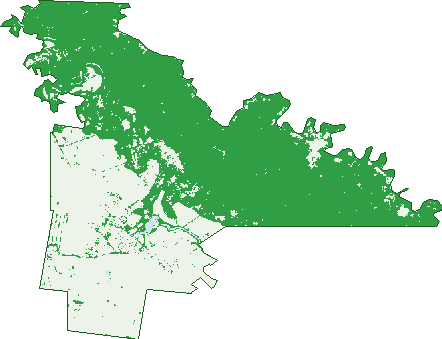
Green: 10 m cells where trees dominate, satellite 2021. Blue: water. The line is the suburb boundary.
| Canopy share, 1 m canopy height map, 2020 | 45.0% |
|---|---|
| Land with trees, 10 m satellite map, 2021 | 62.0% |
Demographics
Unemployment 2.6% · Labour-force participation 46.3%
Population by age in Cohuna
| 0-4 | 105 |
|---|---|
| 5-14 | 235 |
| 15-19 | 91 |
| 20-24 | 86 |
| 25-34 | 173 |
| 35-44 | 218 |
| 45-54 | 289 |
| 55-64 | 345 |
| 65-74 | 455 |
| 75-84 | 301 |
| 85+ | 132 |
Dwelling types in Cohuna
| House | 973 |
|---|---|
| Townhouse | 46 |
| Apartment | 4 |
| Other | 3 |
Households by weekly income in Cohuna
| <$650 | 253 |
|---|---|
| $650-1,499 | 362 |
| $1,500-2,999 | 246 |
| $3,000+ | 82 |
Top ancestries in Cohuna
| English | 1,090 |
|---|---|
| Australian | 1,024 |
| Irish | 270 |
| Scottish | 256 |
| Ancestry NS | 182 |
| German | 86 |
Housing tenure in Cohuna
| Owned | 553 |
|---|---|
| Mortgage | 250 |
| Rented | 184 |
| Other | 29 |
Cars per household in Cohuna
| 0 | 51 |
|---|---|
| 1 | 357 |
| 2 | 386 |
| 3 | 121 |
| 4+ | 90 |
Commute to work in Cohuna
| Car | 714 |
|---|---|
| Train | 0 |
| Bus | 0 |
| Tram/ferry | 0 |
| Walked | 43 |
| Bicycle | 13 |
| Home | 59 |
Top countries of birth in Cohuna
| England | 32 |
|---|---|
| India | 20 |
| Philippines | 14 |
| Netherlands | 13 |
| New Zealand | 8 |
| Canada | 7 |
Languages used at home in Cohuna
| Punjabi | 13 |
|---|---|
| Filipino | 13 |
| Malayalam | 9 |
| Arabic | 5 |
| Afrikaans | 4 |
| Australian Indigenous | 3 |
Birds & Wildlife Nearby
5,212 bird observations recorded near Cohuna — most often seen:
- Galah (264)
- Pacific Black Duck (262)
- Australian Magpie (226)
- Whistling Kite (214)
- Common Starling (212)
- Straw-necked Ibis (210)
- House Sparrow (205)
- Long-billed Corella (193)
- Welcome Swallow (192)
- Australasian Purple Swamphen (181)
- Magpie-lark (180)
- Superb Fairy-wren (180)
- Willie Wagtail (174)
Show all 30 birds recorded near Cohuna
- Grey Teal (171)
- Australian White Ibis (167)
- Black Swan (163)
- Little Raven (162)
- White-plumed Honeyeater (162)
- Crested Pigeon (156)
- Yellow Rosella (155)
- Eurasian Blackbird (151)
- Australian Wood Duck (150)
- Noisy Miner (150)
- White-faced Heron (146)
- Eurasian Coot (138)
- Sulphur-crested Cockatoo (134)
- Australian Shelduck (129)
- Little Pied Cormorant (129)
- Silver Gull (129)
- Dusky Moorhen (127)
Sightings reported by observers, not a survey, so the counts show what people record rather than what lives here. Source: Atlas of Living Australia.
Nearby Suburbs
The closest suburbs to Cohuna:
- Daltons Bridge (5.6 km)
- Cullen (6 km)
- Keely (6.2 km)
- Mcmillans (6.4 km)
- Horfield (8.8 km)
- Mead (9 km)
- Wee Wee Rup (9.1 km)
- Burkes Bridge (10 km)
Embed this suburb
Add this free Cohuna stat card to your own site — just copy the code:
Preview:
Cite this page
Quoting these figures? Copy the credit line:
Keep an eye on Cohuna
One email when this data meaningfully changes — new census figures, prices, rankings. No spam, unsubscribe anytime.
Streets
- Augustine Street (20)
- Bankhead Street (27)
- Barr Park Road (4)
- Barrhead Street (33)
- Barton Place (11)
- Barton Rise (11)
- Belmont Street (23)
- Bradys Road (3)
- Channel Street (158)
- Chuggs Road (8)
- Cohuna Estate School Road (3)
- Cohuna Island Road (33)
- Cohuna-koondrook Road (9)
- Cohuna-leitchville Road (13)
- Cohuna-mcmillans Road (51)
- Cullen Street (42)
- Danahers Road (5)
- Dicksons Road (9)
- Drovers Rest (14)
- Drovers Retreat (14)
- Dunn Street (15)
- Factory Road (3)
- Fairway Crescent (18)
- Farrant Court (12)
- Fehring Court (10)
- Fletchers Road (2)
- Garners Road (1)
- George Street (29)
- Gibbins Drive (23)
- Golf Road (2)
- Greens Road (3)
- Hall Street (36)
- Harrowers Road (2)
- Hay Street (33)
- Heils Road (15)
- Hester Avenue (3)
- Island Rise (17)
- Jacka Road (6)
- Jewell Street (9)
- Keelys Road (2)
- Kennedys Road (5)
- Kerang Road (2)
- Kervins Road (5)
- Kevin Street (13)
- King Edward Street (118)
- King George Street (130)
- Kirby Street (32)
- Leitchville Road (1)
- Livingstone Street (29)
- Lyons Road (13)
- Margaret Street (33)
- Market Street (82)
- Martin Place (13)
- Mathers Road (1)
- Mawsons Road (3)
- Mclennan Street (5)
- Mead Street (20)
- Mill Road (1)
- Mitchell Street (7)
- Murray Street (10)
- Murray Valley Highway (31)
- Nicol Street (7)
- Obriens Road (31)
- Orrland Court (16)
- Packenans Road (1)
- Park Lane (2)
- Pioneer Green (3)
- Railway Avenue (47)
- Redman Lane (2)
- Reids Road (14)
- Rifle Butt Road (2)
- Rosalind Street (28)
- Roviras Road (21)
- Sampson Street (36)
- Settlers Key (46)
- Shearer Place (9)
- Stanley Court (17)
- Stewart Street (2)
- T Mathers Road (1)
- Tennis Road (3)
- Tisdall Road (4)
- Tolls Lane (4)
- Trezises Road (3)
- Vallences Road (6)
- Waitings Road (1)
- Weinberg Street (10)
- Westbrook Street (2)
- Western Road (30)
- Weymouths Road (5)
- William Street (51)