Cockatoo VIC 3781
1,904 addresses · 107 streets
La Trobe Electorate › Cardinia LGA › Cockatoo · 49 km from Melbourne
📦 Thinking of moving here? Read the Cockatoo moving guide

Living Here
Cockatoo is a suburb of Victoria, home to about 4,408 people, with a median age of 36. The typical household earns around $1,991 a week, with median rent near $370 a week. Most homes are houses. About 91% of households own their home and 8% rent. Most workers drive to work. Common community backgrounds include Australian, English, Irish. On the ABS socio-economic scale it sits in decile 6 of 10 nationally — a mid-range area. The median house sells for about $737,500.
Over time — Census 2001 → 2021
Dashed line: district figures for the Emerald - Cockatoo statistical area (SA2), the smallest area the ABS published before 2011. Solid line: Cockatoo itself.
Getting Around & Local Services
1 café or restaurant
1 Catholic church
1 medical clinic
1 dentist
3 childcare & kindergartens
1 library
1 post office
1 service station
1 golf club
2 hardware stores
2 hairdressers
Getting around. Railway halt: Fielder, 1.5 km south-east · Airport: Moorabbin Airport, 35.1 km west.
Sport & Recreation
4 facilities recorded in Cockatoo.
- Cockatoo Bowls & Tennis Club BMX, Lawn Bowls, Skating, Tennis (Outdoor)
- Cockatoo Indoor Sports Complex Basketball
- Josie Bysouth Reserve Equestrian
- Mountain Rd Recreation Reserve Athletics, Australian Rules Football, Cricket, Netball
Socio-economic Standing
Deciles from 1 (lowest) to 10 (highest), against all Australian suburbs. The overall figure weighs advantage and disadvantage together; economic resources counts income and housing, and education & jobs counts qualifications and occupation. They often differ. Source: ABS SEIFA 2021.
Median Sale Prices
Median of recorded sales in the period, not a valuation. Source: Victorian Property Sales Report, Land Use Victoria.
Tree cover
🌳 Tree canopy: 45.1% share of land under canopy · satellite map, 2020
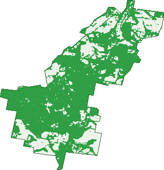
Green: 10 m cells where trees dominate, satellite 2021. Blue: water. The line is the suburb boundary.
| Canopy share, 1 m canopy height map, 2020 | 45.1% |
|---|---|
| Land with trees, 10 m satellite map, 2021 | 72.7% |
Demographics
Unemployment 3.4% · Labour-force participation 67.2%
Population by age in Cockatoo
| 0-4 | 339 |
|---|---|
| 5-14 | 659 |
| 15-19 | 281 |
| 20-24 | 209 |
| 25-34 | 597 |
| 35-44 | 644 |
| 45-54 | 626 |
| 55-64 | 578 |
| 65-74 | 336 |
| 75-84 | 100 |
| 85+ | 31 |
Dwelling types in Cockatoo
| House | 1,427 |
|---|---|
| Townhouse | 0 |
| Apartment | 0 |
| Other | 0 |
Households by weekly income in Cockatoo
| <$650 | 137 |
|---|---|
| $650-1,499 | 333 |
| $1,500-2,999 | 555 |
| $3,000+ | 273 |
Top ancestries in Cockatoo
| Australian | 1,923 |
|---|---|
| English | 1,773 |
| Irish | 475 |
| Scottish | 426 |
| Other | 352 |
| Ancestry NS | 346 |
Housing tenure in Cockatoo
| Owned | 346 |
|---|---|
| Mortgage | 939 |
| Rented | 108 |
| Other | 13 |
Cars per household in Cockatoo
| 0 | 17 |
|---|---|
| 1 | 298 |
| 2 | 616 |
| 3 | 269 |
| 4+ | 209 |
Commute to work in Cockatoo
| Car | 1,411 |
|---|---|
| Train | 0 |
| Bus | 0 |
| Tram/ferry | 0 |
| Walked | 22 |
| Bicycle | 0 |
| Home | 413 |
Top countries of birth in Cockatoo
| England | 179 |
|---|---|
| New Zealand | 59 |
| Netherlands | 24 |
| Scotland | 23 |
| Poland | 16 |
| United States | 16 |
Languages used at home in Cockatoo
| German | 16 |
|---|---|
| Spanish | 16 |
| Polish | 11 |
| Thai | 11 |
| Greek | 9 |
| Russian | 7 |
Birds & Wildlife Nearby
10,605 bird observations recorded near Cockatoo — most often seen:
- Crimson Rosella (676)
- Brown Thornbill (539)
- Helmeted Honeyeater (538)
- Laughing Kookaburra (527)
- Grey Fantail (461)
- Eurasian Blackbird (452)
- Eastern Yellow Robin (434)
- Sulphur-crested Cockatoo (409)
- Superb Fairy-wren (409)
- White-browed Scrubwren (379)
- White-throated Treecreeper (376)
- Australian Magpie (363)
- Australian Wood Duck (340)
Show all 30 birds recorded near Cockatoo
- Red Wattlebird (337)
- Australasian Purple Swamphen (325)
- Grey Shrike-thrush (322)
- Striated Thornbill (317)
- Pied Currawong (310)
- Eastern Spinebill (288)
- Spotted Pardalote (287)
- White-naped Honeyeater (284)
- Grey Butcherbird (277)
- Pacific Black Duck (272)
- Yellow-faced Honeyeater (263)
- Common Myna (260)
- Little Raven (251)
- Golden Whistler (249)
- Eurasian Coot (241)
- Australian King-parrot (218)
- Silvereye (201)
Sightings reported by observers, not a survey, so the counts show what people record rather than what lives here. Source: Atlas of Living Australia.
Nearby Suburbs
The closest suburbs to Cockatoo:
- Avonsleigh (2.6 km)
- Emerald (4.2 km)
- Mount Burnett (4.5 km)
- Gembrook (5.5 km)
- Dewhurst (5.6 km)
- Macclesfield (6 km)
- Clematis (6.6 km)
- Nangana (6.9 km)
Embed this suburb
Add this free Cockatoo stat card to your own site — just copy the code:
Preview:
Cite this page
Quoting these figures? Copy the credit line:
Keep an eye on Cockatoo
One email when this data meaningfully changes — new census figures, prices, rankings. No spam, unsubscribe anytime.
Streets
- Aclare Road (8)
- Alexander Road (28)
- Allenby Avenue (14)
- Amphlett Avenue (19)
- Arthur Road (14)
- Avon Road (1)
- Bailey Road (43)
- Baker Street (40)
- Beatty Parade (16)
- Bedford Road (12)
- Belgrave Avenue (29)
- Belgrave-gembrook Road (62)
- Bell Street (4)
- Bilocla Avenue (18)
- Birdwood Avenue (16)
- Bluebird Avenue (6)
- Boronia Crescent (23)
- Brisbanes Road (13)
- Calder Road (2)
- Carawa Street (29)
- Carcoola Street (3)
- Caroline Avenue (54)
- Church Crescent (8)
- Cockatoo Avenue (9)
- Colin Avenue (10)
- Cullen Place (5)
- Devon Avenue (51)
- Doonaha Road (11)
- Dorchester Road (1)
- Edmunds Road (32)
- Evans Road (38)
- Fairbridge Lane (2)
- Fell Road (6)
- Fern Gully Road (20)
- Fielder Road (11)
- First Avenue (79)
- Flora Close (6)
- Francis Street (8)
- Galah Street (4)
- Garden Street (22)
- George Road (1)
- George Street (1)
- Glen Road (24)
- Goldsack Close (4)
- Gum Street (5)
- Halcyon Grove (10)
- Harold Street (1)
- Haven Court (5)
- Haylock Avenue (22)
- Hazel Street (32)
- Hillcrest Court (11)
- Hillside Road (13)
- Isaac Street (7)
- Ivy Street (9)
- Jeanne Street (22)
- Joffre Parade (38)
- Kilbaha Road (1)
- Kirk Road (11)
- Kitchener Parade (32)
- Lisheen Road (29)
- Lowen Road (3)
- Mackenzie Street (19)
- Maillard Street (12)
- Marcelle Street (5)
- Marion Avenue (4)
- Maurice Street (24)
- Mcbride Street (63)
- Meyer Street (8)
- Moola Road (8)
- Mountain Road (40)
- Nangana Street (13)
- Naughton Street (23)
- Neville Street (44)
- Nioka Close (4)
- Old Gembrook Road (9)
- Old Soldier Road (1)
- Oonah Street (6)
- Osier Place (2)
- Pakenham Road (44)
- Paternoster Road (46)
- Phillip Road (2)
- Railway Parade (1)
- Rainy Hill Road (28)
- Ravenhill Close (1)
- Rouen Road (6)
- Salisbury Avenue (14)
- Seaview Road (36)
- Second Avenue (55)
- Simmons Close (4)
- Sixth Avenue (1)
- Springs Street (41)
- Station Road (2)
- Steane Street (28)
- Stringybark Road (10)
- Suffolk Avenue (13)
- Tarrana Street (5)
- Taylor Road (4)
- Terara Street (10)
- Third Avenue (3)
- Tymon Road (6)
- Ure Road (5)
- View Hill Road (50)
- Vincent Street (7)
- Waratah Way (21)
- Woodlands Avenue (4)
- Woodrow Court (5)
- Woori Yallock Road (109)