Christmas Hills VIC 3775
253 addresses · 25 streets
McEwen Electorate › Nillumbik LGA › Christmas Hills · 35 km from Melbourne

Living Here
Christmas Hills is a suburb of Victoria, home to about 365 people, with a median age of 46. The typical household earns around $2,285 a week, with median rent near $353 a week. Most homes are houses. About 91% of households own their home and 9% rent. Most workers drive to work. Common community backgrounds include English, Australian, Irish. On the ABS socio-economic scale it sits in decile 10 of 10 nationally — a relatively advantaged area.
Over time — Census 2001 → 2021
Dashed line: district figures for the Panton Hill - St Andrews statistical area (SA2), the smallest area the ABS published before 2011. Solid line: Christmas Hills itself.
Getting Around & Local Services
1 school
1 park
1 library
Getting around. Train station: Lilydale, 11.4 km south · Airport: Essendon Fields Airport, 37 km west.
Sport & Recreation
1 facility recorded in Christmas Hills.
- Sugarloaf Sailing Club Sailing
Socio-economic Standing
Deciles from 1 (lowest) to 10 (highest), against all Australian suburbs. The overall figure weighs advantage and disadvantage together; economic resources counts income and housing, and education & jobs counts qualifications and occupation. They often differ. Source: ABS SEIFA 2021.
Tree cover
🌳 Tree canopy: 63.8% share of land under canopy · satellite map, 2020
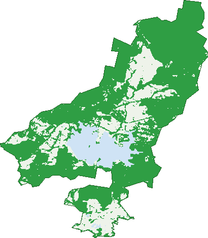
Green: 10 m cells where trees dominate, satellite 2021. Blue: water. The line is the suburb boundary.
| Canopy share, 1 m canopy height map, 2020 | 63.8% |
|---|---|
| Land with trees, 10 m satellite map, 2021 | 75.6% |
Demographics
Unemployment 0.9% · Labour-force participation 68.7%
Population by age in Christmas Hills
| 0-4 | 16 |
|---|---|
| 5-14 | 38 |
| 15-19 | 24 |
| 20-24 | 24 |
| 25-34 | 30 |
| 35-44 | 49 |
| 45-54 | 58 |
| 55-64 | 84 |
| 65-74 | 36 |
| 75-84 | 17 |
| 85+ | 4 |
Dwelling types in Christmas Hills
| House | 126 |
|---|---|
| Townhouse | 0 |
| Apartment | 0 |
| Other | 0 |
Households by weekly income in Christmas Hills
| <$650 | 10 |
|---|---|
| $650-1,499 | 27 |
| $1,500-2,999 | 32 |
| $3,000+ | 42 |
Top ancestries in Christmas Hills
| English | 168 |
|---|---|
| Australian | 137 |
| Irish | 50 |
| Scottish | 49 |
| Italian | 21 |
| German | 20 |
Housing tenure in Christmas Hills
| Owned | 50 |
|---|---|
| Mortgage | 63 |
| Rented | 11 |
| Other | 0 |
Cars per household in Christmas Hills
| 0 | 0 |
|---|---|
| 1 | 14 |
| 2 | 46 |
| 3 | 38 |
| 4+ | 32 |
Commute to work in Christmas Hills
| Car | 135 |
|---|---|
| Train | 0 |
| Bus | 0 |
| Tram/ferry | 0 |
| Walked | 0 |
| Bicycle | 0 |
| Home | 43 |
Top countries of birth in Christmas Hills
| England | 18 |
|---|---|
| China | 7 |
| Malta | 5 |
| New Zealand | 3 |
| Scotland | 3 |
| United States | 3 |
Languages used at home in Christmas Hills
| Mandarin | 5 |
|---|
Birds & Wildlife Nearby
34,076 bird observations recorded near Christmas Hills — most often seen:
- Superb Fairy-wren (1,743)
- Grey Fantail (1,738)
- Grey Shrike-thrush (1,616)
- Brown Thornbill (1,561)
- Australian Magpie (1,521)
- Crimson Rosella (1,420)
- Red Wattlebird (1,418)
- Laughing Kookaburra (1,340)
- Yellow-faced Honeyeater (1,282)
- Eastern Yellow Robin (1,272)
- White-throated Treecreeper (1,233)
- White-naped Honeyeater (1,220)
- Spotted Pardalote (1,214)
Show all 30 birds recorded near Christmas Hills
- Sulphur-crested Cockatoo (1,178)
- Little Raven (1,159)
- White-eared Honeyeater (1,101)
- Striated Thornbill (1,049)
- Pied Currawong (981)
- White-browed Scrubwren (970)
- Grey Butcherbird (956)
- Silvereye (918)
- Eurasian Blackbird (884)
- Eastern Spinebill (865)
- Rufous Whistler (844)
- Welcome Swallow (819)
- Striated Pardalote (776)
- Fan-tailed Cuckoo (764)
- White-winged Chough (748)
- Rainbow Lorikeet (745)
- Galah (741)
Sightings reported by observers, not a survey, so the counts show what people record rather than what lives here. Source: Atlas of Living Australia.
Nearby Suburbs
The closest suburbs to Christmas Hills:
- Smiths Gully (4.5 km)
- Watsons Creek (4.7 km)
- Bend Of Islands (5.4 km)
- Yarra Glen (5.6 km)
- Yering (6.3 km)
- Panton Hill (6.3 km)
- St Andrews (7.6 km)
- Kangaroo Ground (8 km)
Embed this suburb
Add this free Christmas Hills stat card to your own site — just copy the code:
Preview:
Cite this page
Quoting these figures? Copy the credit line:
Keep an eye on Christmas Hills
One email when this data meaningfully changes — new census figures, prices, rankings. No spam, unsubscribe anytime.
Streets
- Ashmore Road (3)
- Buttermans Track (18)
- Calwell Road (7)
- Dean Road (3)
- Eltham-yarra Glen Road (22)
- Henley Bridge Road (8)
- Henley Road (1)
- Marshalls Road (2)
- Mckinnon Terrace (12)
- Moorool Court (3)
- Muir Road (6)
- One Tree Hill Road (12)
- Osborne Road (5)
- Osheas Road (6)
- Reeves Road (10)
- Ridge Road (33)
- Scholz Road (3)
- School Lane (1)
- Simpson Road (3)
- Skyline Road (28)
- Sugarloaf Track (8)
- Tanderum Way (4)
- Wallace Road (15)
- Wendy Way (2)
- Westering Road (38)