Cairnlea VIC 3023
3,511 addresses · 168 streets
Fraser Electorate › Brimbank LGA › Cairnlea · 17 km from Melbourne
📦 Thinking of moving here? Read the Cairnlea moving guide

Living Here
Cairnlea is a suburb of Victoria, home to about 10,038 people, with a median age of 36. The typical household earns around $2,062 a week, with median rent near $400 a week. Most homes are houses. About 84% of households own their home and 15% rent. Most workers drive to work. Common community backgrounds include Vietnamese, Chinese, Australian. On the ABS socio-economic scale it sits in decile 4 of 10 nationally — a mid-range area. The median house sells for about $932,500.
Over time — Census 2001 → 2021
Dashed line: district figures for the Cairnlea statistical area (SA2), the smallest area the ABS published before 2011. Solid line: Cairnlea itself.
Getting Around & Local Services
55 schools
- Cairnlea Park Primary School
- Victoria University Secondary College Cairnlea Senior Campus
- Deer Park North Primary School
- University Park Primary School
- St Peter Chanel School
- Victoria University Secondary College Deer Park Campus
- Albanvale Primary School
- Victoria University Secondary College Brimbank Campus
- Holy Eucharist Primary School
- St Albans Secondary College
12 Catholic churches
1 physiotherapist
3 post offices
3 electricians
Getting around. Train station: St Albans, 2 km north-east · Bus interchange: St Albans Station/St Albans Road, 2 km north-east · Airport: Melbourne Airport, 10.6 km north.
Sport & Recreation
3 facilities recorded in Cairnlea.
- Cairnlea Park Australian Rules Football, Soccer
- Elford Court Green Basketball
- Kevin Flint Reserve Australian Rules Football, Cricket, Soccer
Socio-economic Standing
Deciles from 1 (lowest) to 10 (highest), against all Australian suburbs. The overall figure weighs advantage and disadvantage together; economic resources counts income and housing, and education & jobs counts qualifications and occupation. They often differ. Source: ABS SEIFA 2021.
Median Sale Prices
Median of recorded sales in the period, not a valuation. Source: Victorian Property Sales Report, Land Use Victoria.
Tree cover
🌳 Tree canopy: 3.4% share of land under canopy · satellite map, 2020
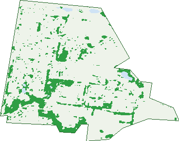
Green: 10 m cells where trees dominate, satellite 2021. Blue: water. The line is the suburb boundary.
| Canopy share, 1 m canopy height map, 2020 | 3.4% |
|---|---|
| Land with trees, 10 m satellite map, 2021 | 11.9% |
Demographics
Unemployment 6.6% · Labour-force participation 62.1%
Population by age in Cairnlea
| 0-4 | 507 |
|---|---|
| 5-14 | 1,422 |
| 15-19 | 780 |
| 20-24 | 764 |
| 25-34 | 1,319 |
| 35-44 | 1,431 |
| 45-54 | 1,558 |
| 55-64 | 1,222 |
| 65-74 | 718 |
| 75-84 | 221 |
| 85+ | 92 |
Dwelling types in Cairnlea
| House | 2,480 |
|---|---|
| Townhouse | 212 |
| Apartment | 106 |
| Other | 0 |
Households by weekly income in Cairnlea
| <$650 | 293 |
|---|---|
| $650-1,499 | 637 |
| $1,500-2,999 | 984 |
| $3,000+ | 703 |
Top ancestries in Cairnlea
| Vietnamese | 3,009 |
|---|---|
| Other | 2,136 |
| Chinese | 1,244 |
| Australian | 929 |
| Filipino | 696 |
| English | 644 |
Housing tenure in Cairnlea
| Owned | 920 |
|---|---|
| Mortgage | 1,381 |
| Rented | 420 |
| Other | 34 |
Cars per household in Cairnlea
| 0 | 78 |
|---|---|
| 1 | 619 |
| 2 | 1,191 |
| 3 | 561 |
| 4+ | 332 |
Commute to work in Cairnlea
| Car | 2,964 |
|---|---|
| Train | 94 |
| Bus | 15 |
| Tram/ferry | 0 |
| Walked | 28 |
| Bicycle | 0 |
| Home | 895 |
Top countries of birth in Cairnlea
| Vietnam | 2,107 |
|---|---|
| Philippines | 449 |
| India | 256 |
| North Macedonia | 174 |
| Bosnia & Herzegovina | 142 |
| China | 132 |
Languages used at home in Cairnlea
| Vietnamese | 3,145 |
|---|---|
| Cantonese | 406 |
| Tagalog | 255 |
| Macedonian | 248 |
| Punjabi | 172 |
| Arabic | 170 |
Birds & Wildlife Nearby
23,097 bird observations recorded near Cairnlea — most often seen:
- Little Raven (1,478)
- Common Myna (1,425)
- Common Starling (1,212)
- House Sparrow (1,157)
- Pacific Black Duck (1,083)
- Dusky Moorhen (1,005)
- Magpie-lark (945)
- Australian Magpie (943)
- Rainbow Lorikeet (925)
- Red Wattlebird (908)
- Rock Dove (868)
- Eurasian Blackbird (817)
- New Holland Honeyeater (816)
Show all 30 birds recorded near Cairnlea
- Eurasian Coot (797)
- White-plumed Honeyeater (790)
- Spotted Turtle-dove (760)
- Willie Wagtail (725)
- Australasian Purple Swamphen (718)
- Crested Pigeon (714)
- Welcome Swallow (647)
- Silver Gull (612)
- Little Pied Cormorant (520)
- Black Swan (514)
- Superb Fairy-wren (492)
- Australian Pelican (434)
- Australian White Ibis (424)
- White-faced Heron (365)
- Australian Wood Duck (351)
- Southern Victoria Australian Magpie (343)
- Chestnut Teal (309)
Sightings reported by observers, not a survey, so the counts show what people record rather than what lives here. Source: Atlas of Living Australia.
Nearby Suburbs
The closest suburbs to Cairnlea:
Embed this suburb
Add this free Cairnlea stat card to your own site — just copy the code:
Preview:
Cite this page
Quoting these figures? Copy the credit line:
Keep an eye on Cairnlea
One email when this data meaningfully changes — new census figures, prices, rankings. No spam, unsubscribe anytime.
Streets
- Alba Walk (14)
- Ambleside Place (6)
- Appletree Grove (10)
- Autumn Grove (9)
- Bannes Road (14)
- Barring Boulevard (14)
- Barrwang Street (16)
- Bill Carn Avenue (29)
- Billy Buttons Avenue (18)
- Blackwood Court (20)
- Braywood Terrace (21)
- Breadalbane Avenue (25)
- Brinkhill Court (8)
- Brookglen Boulevard (29)
- Cairnlea Drive (292)
- Carmody Drive (29)
- Cavanagh Close (9)
- Chesterfield Road (48)
- Chlosam Court (4)
- Chlosam Road (12)
- Clare Brennan Drive (25)
- Clarian Street (17)
- Cochrane Street (13)
- Coomgarie Terrace (25)
- Cormorant Drive (30)
- Cricklewood Lane (8)
- Delma Avenue (11)
- Delmar Walk (14)
- Dianella Street (6)
- Dighton Terrace (12)
- Drystone Crescent (45)
- Dunbarrim Avenue (57)
- Eaglehawk Circuit (16)
- Eden Valley Road (25)
- Edgewater Circuit (25)
- Edgewood Court (7)
- Egret Crescent (26)
- Elford Court (7)
- Elmsted Court (12)
- Faddie Street (13)
- Fairfield Walk (4)
- Farmington Road (18)
- Federation Walk (7)
- Flowerdale Road (25)
- Foxdale Place (12)
- Furlong Road (254)
- Gardenia Place (4)
- Gladstone Street (1)
- Glenbrook Avenue (36)
- Glenfield Close (5)
- Grassland Crescent (19)
- Grassy Point Road (21)
- Greenstead Way (23)
- Grovedale Circuit (44)
- Gumleaf Court (5)
- Gunuwarra Road (13)
- Gurnung Drive (53)
- Gurrin Road (8)
- Havenlea Lane (14)
- Heron Road (21)
- Heronswood Road (8)
- Hideaway Lane (8)
- Highcroft Place (19)
- Highfield Road (22)
- Homebush Road (43)
- Honeyeater Terrace (18)
- Ibis Grove (12)
- Inverness Court (12)
- Japonica Court (12)
- Jasmine Road (12)
- Jim Clay Avenue (11)
- Jonesfield Corner (10)
- Ken Jordan Road (23)
- Kiama Place (18)
- Kimberley Road (10)
- Kingsbridge Circuit (23)
- Lakefield Way (22)
- Lakewood Boulevard (31)
- Lansdowne Road (32)
- Lantern Court (8)
- Lavender Park Road (4)
- Lobelia Grove (8)
- Lomandra Way (6)
- Longwood Avenue (25)
- Lotus Crescent (24)
- Lynne Maree Avenue (35)
- Magazine Avenue (12)
- Mallebush Avenue (8)
- Mariem Road (19)
- Marsh Mays Road (14)
- Meadowview Way (18)
- Meehan Street (24)
- Millstream Circuit (22)
- Minuria Lane (1)
- Minvi Terrace (38)
- Mochrie Grove (20)
- Moorland Road (32)
- Mumil Court (2)
- Newhaven Way (14)
- Newland Walk (8)
- Ngami Road (16)
- Nobel Banks Drive (61)
- Oakford Place (8)
- Oatlands Lane (9)
- Pampas Lane (6)
- Pampas Walk (1)
- Parklea Avenue (22)
- Pawleena Circuit (33)
- Pembrey Road (20)
- Peppermint Grove (10)
- Pinewood Crescent (30)
- Pipers Walk (10)
- Playhouse Avenue (16)
- Primrose Court (16)
- Prospector Drive (35)
- Rangeview Street (22)
- Ravenswood Walk (9)
- Reg Chalke Crescent (29)
- River Gum Court (5)
- Roseberry Avenue (18)
- Rosewood Lane (8)
- Saltmarsh Place (11)
- Sandpiper Street (24)
- Sandygate Court (19)
- Sapling Terrace (13)
- Sedgefield Terrace (13)
- Settlers Way (19)
- Shearwater Court (9)
- Sheffield Court (9)
- Sheoke Grove (26)
- Shepperd Way (18)
- Silverdale Walk (15)
- Solomon Drive (16)
- Spearfelt Court (8)
- Spinifex Street (27)
- Squatters Track (1)
- Station Road (85)
- Stockton Drive (52)
- Stonewall Close (8)
- Sugargum Grove (20)
- Sullivan Road (31)
- Sunnybrae Circuit (33)
- Sunnyside Way (19)
- Teal Court (6)
- Thistledown Court (3)
- Tillbrook Grove (5)
- Tom Rigg Street (17)
- Treemont Court (10)
- Truesource Drive (21)
- Tunbridge Road (18)
- Tussock Grove (25)
- Verbena Court (9)
- Vince Stella Close (17)
- Walert Street (8)
- Warin Road (4)
- Washford Lane (9)
- Waterview Drive (26)
- Waterview Lane (14)
- Wattle Grove Road (11)
- Weaver Terrace (16)
- Westbrook Place (13)
- Westbury Street (14)
- Wildflower Lane (10)
- Winnunga Road (13)
- Woodburn Avenue (39)
- Woodsdale Court (16)
- Woolshed Avenue (24)
- Yirram Road (7)