Burnside Heights VIC 3023
1,949 addresses · 87 streets
Gorton Electorate › Melton LGA › Burnside Heights · 20 km from Melbourne
📦 Thinking of moving here? Read the Burnside Heights moving guide

Living Here
Burnside Heights is a suburb of Victoria, home to about 6,377 people, with a median age of 33. The typical household earns around $2,246 a week, with median rent near $411 a week. Most homes are houses. About 82% of households own their home and 18% rent. Most workers drive to work. Common community backgrounds include Indian, Australian, Vietnamese. On the ABS socio-economic scale it sits in decile 7 of 10 nationally — a mid-range area. The median house sells for about $749,000.
Over time — Census 2001 → 2021
Dashed line: district figures for the Caroline Springs statistical area (SA2), the smallest area the ABS published before 2011. Solid line: Burnside Heights itself.
Getting Around & Local Services
48 schools
- Kororoit Creek Primary School
- Gilson College
- Kings Park Primary School
- Copperfield College Kings Park Junior Campus
- Lakeview Senior College
- Australian International Academy Caroline Springs Campus
- Catholic Regional College Caroline Springs
- Burnside Primary School
- Creekside College
- Taylors Hill Primary School
7 supermarkets
3 physiotherapists
4 optometrists
2 post offices
9 service stations
4 hardware stores
1 electrician
3 plumbers
Getting around. Train station: Keilor Plains, 3.3 km east · Bus interchange: Watergardens Station, 3.7 km north-east · Airport: Melbourne Airport, 9.4 km north-east.
Sport & Recreation
2 facilities recorded in Burnside Heights.
- Burnside Heights Recreation Reserve Australian Rules Football, Cricket
- YMCA Kororoit Creek Swimming
Socio-economic Standing
Deciles from 1 (lowest) to 10 (highest), against all Australian suburbs. The overall figure weighs advantage and disadvantage together; economic resources counts income and housing, and education & jobs counts qualifications and occupation. They often differ. Source: ABS SEIFA 2021.
Median Sale Prices
Median of recorded sales in the period, not a valuation. Source: Victorian Property Sales Report, Land Use Victoria.
Tree cover
🌳 Tree canopy: 1.6% share of land under canopy · satellite map, 2020
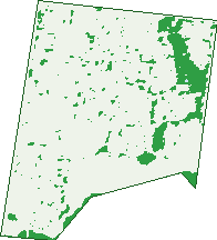
Green: 10 m cells where trees dominate, satellite 2021. Blue: water. The line is the suburb boundary.
| Canopy share, 1 m canopy height map, 2020 | 1.6% |
|---|---|
| Land with trees, 10 m satellite map, 2021 | 8.3% |
Demographics
Unemployment 6.8% · Labour-force participation 70.6%
Population by age in Burnside Heights
| 0-4 | 454 |
|---|---|
| 5-14 | 1,382 |
| 15-19 | 431 |
| 20-24 | 356 |
| 25-34 | 673 |
| 35-44 | 1,441 |
| 45-54 | 818 |
| 55-64 | 455 |
| 65-74 | 267 |
| 75-84 | 78 |
| 85+ | 11 |
Dwelling types in Burnside Heights
| House | 1,565 |
|---|---|
| Townhouse | 162 |
| Apartment | 0 |
| Other | 0 |
Households by weekly income in Burnside Heights
| <$650 | 122 |
|---|---|
| $650-1,499 | 344 |
| $1,500-2,999 | 639 |
| $3,000+ | 510 |
Top ancestries in Burnside Heights
| Other | 1,904 |
|---|---|
| Indian | 784 |
| Australian | 741 |
| Vietnamese | 600 |
| English | 525 |
| Filipino | 446 |
Housing tenure in Burnside Heights
| Owned | 316 |
|---|---|
| Mortgage | 1,064 |
| Rented | 309 |
| Other | 4 |
Cars per household in Burnside Heights
| 0 | 28 |
|---|---|
| 1 | 361 |
| 2 | 866 |
| 3 | 303 |
| 4+ | 145 |
Commute to work in Burnside Heights
| Car | 1,763 |
|---|---|
| Train | 43 |
| Bus | 14 |
| Tram/ferry | 0 |
| Walked | 16 |
| Bicycle | 3 |
| Home | 692 |
Top countries of birth in Burnside Heights
| India | 694 |
|---|---|
| Vietnam | 385 |
| Philippines | 296 |
| Pakistan | 143 |
| New Zealand | 99 |
| North Macedonia | 87 |
Languages used at home in Burnside Heights
| Vietnamese | 615 |
|---|---|
| Punjabi | 313 |
| Hindi | 238 |
| Arabic | 210 |
| Urdu | 199 |
| Macedonian | 197 |
Nearby Suburbs
The closest suburbs to Burnside Heights:
- Kings Park (1.4 km)
- Caroline Springs (1.6 km)
- Taylors Hill (1.8 km)
- Burnside (2 km)
- Albanvale (2 km)
- Delahey (2.1 km)
- Sydenham (3.6 km)
- Ravenhall (4.1 km)
Embed this suburb
Add this free Burnside Heights stat card to your own site — just copy the code:
Preview:
Cite this page
Quoting these figures? Copy the credit line:
Keep an eye on Burnside Heights
One email when this data meaningfully changes — new census figures, prices, rankings. No spam, unsubscribe anytime.
Streets
- Adderley Court (5)
- Albert Court (12)
- Appletree Grove (8)
- Arbour Boulevard (159)
- Ashridge Court (14)
- Atherton Avenue (29)
- Barton Road (7)
- Batman Street (40)
- Beechwood Grove (10)
- Belleville Close (40)
- Blaxland Street (33)
- Brookvale Avenue (4)
- Bruce Street (16)
- Bungaree Track (17)
- Burke Road (22)
- Catani Court (14)
- Centennial Place (10)
- Chelsea Court (19)
- Chifley Circuit (43)
- Como Avenue (28)
- Connor Drive (46)
- Cooma Place (17)
- Cunningham Chase (53)
- Deakin Grove (28)
- Domain Avenue (26)
- Easleys Place (4)
- Evatt Terrace (5)
- Florida Court (17)
- Forrest Street (11)
- Freelands Drive (40)
- Giverny Close (34)
- Green Court (14)
- Harrison Court (30)
- Harwood Court (16)
- Hovell Drive (24)
- Hughes Place (10)
- Hyde Close (16)
- Inglewood Drive (75)
- Inverell Street (19)
- Ironbark Grove (21)
- Jonathan Place (2)
- Katrina Drive (83)
- Ken James Place (12)
- Langbourne Way (13)
- Lawson Place (21)
- Lee Place (6)
- Leichhardt Avenue (42)
- Lyons Avenue (36)
- Manny Paul Circuit (56)
- Menzies Drive (42)
- Mikayla Court (3)
- Millport Drive (12)
- Mimosa Way (35)
- Muscat Avenue (19)
- Naomi Street (11)
- Pamela Place (5)
- Parkes Way (27)
- Peartree Grove (16)
- Priscilla Street (6)
- Redbox Crescent (25)
- Regent Close (16)
- Remington Street (9)
- Rokewood Street (11)
- Romina Court (4)
- Ryans Court (14)
- Saviour Road (3)
- Scales Lane (20)
- Scullin Road (11)
- St James Close (10)
- Stanthorp Street (27)
- Stephen Street (5)
- Stonehaven Drive (1)
- Syon Court (16)
- Taylors Road (4)
- Tenterfield Drive (107)
- Waterside Drive (13)
- Watervale Road (1)
- Wattletree Court (6)
- Wentworth Lane (3)
- West Highland Drive (19)
- Westwood Drive (1)
- Whernside Street (4)
- Wilkins Crescent (32)
- Wills Terrace (45)
- Winterton Court (18)
- Wylie Circuit (34)
- Yellowgum Street (7)