Brown Hill VIC 3350
2,759 addresses · 120 streets
Ballarat Electorate › Ballarat LGA › Brown Hill · 97 km from Melbourne
📦 Thinking of moving here? Read the Brown Hill moving guide

Living Here
Brown Hill is a suburb of Victoria, home to about 4,489 people, with a median age of 36. The typical household earns around $1,757 a week, with median rent near $290 a week. Most homes are houses. About 74% of households own their home and 25% rent. Most workers drive to work. Common community backgrounds include English, Australian, Irish. On the ABS socio-economic scale it sits in decile 7 of 10 nationally — a mid-range area. The median house sells for about $625,000.
Over time — Census 2001 → 2021
Dashed line: district figures for the Ballarat - North statistical area (SA2), the smallest area the ABS published before 2011. Solid line: Brown Hill itself.
Getting Around & Local Services
2 cafés & restaurants
1 supermarket
1 pharmacy
3 optometrists
1 childcare centre
5 service stations
1 dog park
3 hardware stores
1 hairdresser
1 mechanic
Getting around. Train station: Ballarat, 4.2 km west · Railway halt: Invermay Miniature Railway, 4.3 km north-west · Bus interchange: Ballarat Station, 4.3 km west.
Sport & Recreation
2 facilities recorded in Brown Hill.
- Brown Hill Recreation Reserve Athletics, Cricket, Soccer
- Brown Hill Swimming Pool Swimming
Socio-economic Standing
Deciles from 1 (lowest) to 10 (highest), against all Australian suburbs. The overall figure weighs advantage and disadvantage together; economic resources counts income and housing, and education & jobs counts qualifications and occupation. They often differ. Source: ABS SEIFA 2021.
Median Sale Prices
Median of recorded sales in the period, not a valuation. Source: Victorian Property Sales Report, Land Use Victoria.
Tree cover
🌳 Tree canopy: 27.9% share of land under canopy · satellite map, 2020
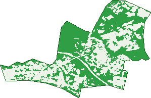
Green: 10 m cells where trees dominate, satellite 2021. Blue: water. The line is the suburb boundary.
| Canopy share, 1 m canopy height map, 2020 | 27.9% |
|---|---|
| Land with trees, 10 m satellite map, 2021 | 54.9% |
Demographics
Unemployment 3% · Labour-force participation 67.3%
Population by age in Brown Hill
| 0-4 | 382 |
|---|---|
| 5-14 | 580 |
| 15-19 | 194 |
| 20-24 | 225 |
| 25-34 | 709 |
| 35-44 | 672 |
| 45-54 | 507 |
| 55-64 | 540 |
| 65-74 | 434 |
| 75-84 | 190 |
| 85+ | 59 |
Dwelling types in Brown Hill
| House | 1,513 |
|---|---|
| Townhouse | 200 |
| Apartment | 6 |
| Other | 3 |
Households by weekly income in Brown Hill
| <$650 | 243 |
|---|---|
| $650-1,499 | 473 |
| $1,500-2,999 | 591 |
| $3,000+ | 336 |
Top ancestries in Brown Hill
| English | 1,901 |
|---|---|
| Australian | 1,869 |
| Irish | 783 |
| Scottish | 568 |
| Other | 234 |
| Italian | 196 |
Housing tenure in Brown Hill
| Owned | 509 |
|---|---|
| Mortgage | 763 |
| Rented | 425 |
| Other | 12 |
Cars per household in Brown Hill
| 0 | 64 |
|---|---|
| 1 | 546 |
| 2 | 757 |
| 3 | 212 |
| 4+ | 126 |
Commute to work in Brown Hill
| Car | 1,572 |
|---|---|
| Train | 5 |
| Bus | 18 |
| Tram/ferry | 0 |
| Walked | 18 |
| Bicycle | 12 |
| Home | 350 |
Top countries of birth in Brown Hill
| England | 106 |
|---|---|
| India | 33 |
| New Zealand | 27 |
| Scotland | 16 |
| Netherlands | 14 |
| Philippines | 14 |
Languages used at home in Brown Hill
| Punjabi | 15 |
|---|---|
| Italian | 15 |
| Mandarin | 11 |
| Greek | 10 |
| Japanese | 8 |
| Filipino | 8 |
Birds & Wildlife Nearby
20,585 bird observations recorded near Brown Hill — most often seen:
- Australian Magpie (1,486)
- Little Raven (1,321)
- Red Wattlebird (1,288)
- Crimson Rosella (1,264)
- Eurasian Blackbird (1,242)
- Rainbow Lorikeet (1,073)
- Galah (815)
- Brown Thornbill (727)
- Magpie-lark (717)
- Superb Fairy-wren (708)
- Pacific Black Duck (669)
- Grey Fantail (642)
- New Holland Honeyeater (640)
Show all 30 birds recorded near Brown Hill
- Common Bronzewing (596)
- House Sparrow (586)
- Common Starling (577)
- Australian Wood Duck (523)
- Grey Currawong (509)
- White-naped Honeyeater (494)
- Pied Currawong (473)
- Southern Victoria Australian Magpie (467)
- Laughing Kookaburra (465)
- White-browed Scrubwren (464)
- Yellow-faced Honeyeater (438)
- Spotted Pardalote (423)
- Eastern Yellow Robin (405)
- White-throated Treecreeper (402)
- Silvereye (396)
- Grey Shrike-thrush (388)
- Grey Butcherbird (387)
Sightings reported by observers, not a survey, so the counts show what people record rather than what lives here. Source: Atlas of Living Australia.
Nearby Suburbs
The closest suburbs to Brown Hill:
- Nerrina (1.8 km)
- Gong Gong (2.2 km)
- Eureka (2.6 km)
- Ballarat East (2.6 km)
- Warrenheip (2.7 km)
- Black Hill (3.2 km)
- Ballarat North (3.7 km)
- Bakery Hill (3.8 km)
Embed this suburb
Add this free Brown Hill stat card to your own site — just copy the code:
Preview:
Cite this page
Quoting these figures? Copy the credit line:
Keep an eye on Brown Hill
One email when this data meaningfully changes — new census figures, prices, rankings. No spam, unsubscribe anytime.
Streets
- Ada Rose Heights (10)
- Ainley Street (25)
- Ambience Place (18)
- Apple Orchard Drive (41)
- Appleford Court (9)
- Arkansaw Court (7)
- Bawden Street (22)
- Bells Lane (11)
- Benson Street (15)
- Bismark Court (7)
- Blanc Court (20)
- Bolero Court (7)
- Boundary Road (27)
- Bowlea Close (17)
- Bradbury Street (73)
- Braeburn Court (6)
- Brewery Tap Road (3)
- Brooklyn Court (13)
- Brophy Street (45)
- Burgadale Court (6)
- Caledonian Place (8)
- Canterbury Street (101)
- Catherine Court (20)
- Cherohne Court (7)
- Chiara Court (29)
- Cider Court (6)
- Cityscape Court (5)
- Cloudbreak Circuit (40)
- Coorabin Drive (10)
- Cypress Road (19)
- Dalma Court (6)
- Daylesford Road (84)
- Delmela Court (8)
- Ditchfield Lane (13)
- Ditchfield Road (10)
- Duggan Street (24)
- Finlay Street (64)
- Florence Court (13)
- Foynes Court (8)
- Gala Close (32)
- Galibier Road (10)
- Gallowburn Court (7)
- Glandon Court (7)
- Gong Gong Road (1)
- Gracefield Drive (17)
- Gracefield Road (68)
- Grolmen Court (5)
- Gum View Close (8)
- Haines Street (43)
- Hearn Road (11)
- Heron Ridge (13)
- Hill Top Road (23)
- Hillview Road (61)
- Holmsgarth Court (20)
- Home Valley Chase (15)
- Home Valley Court (19)
- Hugo Place (8)
- Humffray Street N (275)
- Illana Street (24)
- Janson Road (44)
- Jarvie Court (4)
- Joeys Place (17)
- Jonathan Court (21)
- Jones Street (4)
- Jordy Place (17)
- Kingfisher Court (3)
- Kirrily Chase (14)
- Kirrily Court (14)
- Lanah Place (9)
- Lane Street (36)
- Lautaret Road (16)
- Lawless Place (11)
- Locmor Drive (14)
- Longs Hill Road (4)
- Lookout Court (5)
- Lorbenik Court (4)
- Ludbrook Court (17)
- Madeleine Road (6)
- Malcolm Court (17)
- Mallee Rise (8)
- Mancev Court (7)
- Mcauley Drive (8)
- Melbourne Road (81)
- Middlin Street (22)
- Moneill Close (7)
- Morres Street (9)
- Ninox Court (7)
- Observation Court (15)
- Orchard Lane (15)
- Palentino Place (9)
- Pania Street (24)
- Pardalote Court (4)
- Provence Court (10)
- Raymond Crescent (14)
- Reid Court (1)
- Reid Street (44)
- Ritchie Street (34)
- Riverside Place (20)
- Rusty Rise (15)
- Ryan Street (81)
- Sawmill Close (9)
- Scott Parade (104)
- Sinclair Grove (5)
- Souter Court (6)
- Springs Road (64)
- Stawell Street N (9)
- Strickland Parade (21)
- Stringybark Drive (21)
- Summit Crescent (17)
- Susan Court (5)
- Swift Rise (18)
- Thompson Street (52)
- Thyanver Court (11)
- Triller Court (3)
- Water Street (97)
- Whistler Close (16)
- Willowbank Way (30)
- Wombat Place (5)
- Woodmans Rise (12)
- Woodrush Court (18)