Boronia VIC 3155
13,898 addresses · 307 streets
Aston Electorate › Knox LGA › Boronia · 29 km from Melbourne
📦 Thinking of moving here? Read the Boronia moving guide

Living Here
An outer-eastern Melbourne suburb near the Dandenong foothills, Boronia is affordable and family-oriented. Households average 2.4 people and the median age is 39. Median household income is $1,619 a week, with rent around $376.
Boronia is a suburb of Victoria, home to about 23,607 people, with a median age of 39. The typical household earns around $1,619 a week, with median rent near $376 a week. Most homes are houses. About 71% of households own their home and 28% rent. Most workers drive to work. Common community backgrounds include English, Australian, Irish. On the ABS socio-economic scale it sits in decile 6 of 10 nationally — a mid-range area. The median house sells for about $849,500.
Over time — Census 2001 → 2021
Dashed line: district figures for the Boronia - The Basin statistical area (SA2), the smallest area the ABS published before 2011. Solid line: Boronia itself.
Getting Around & Local Services
22 childcare & kindergartens
1 dog park
Getting around. Train station: Boronia, 350 m south-east · Bus interchange: Boronia Station, 250 m south-east · Airport: Moorabbin Airport, 21 km south-west.
Sport & Recreation
16 facilities recorded in Boronia, the first 10 below.
- AMF Boronia Ten Pin Bowling
- Batterham Reserve Australian Rules Football, Cricket, Tennis (Outdoor)
- Beach House Health & Fitness Boronia Aerobics, Fitness / Gymnasium Workouts
- Beaver Swim School Pty Ltd Swimming
- Boronia Bowls Club Lawn Bowls
- Boronia Busybodies Health & Fitness Centre Aerobics, Fitness / Gymnasium Workouts, Swimming
- Boronia Reserve Public Tennis Courts Tennis (Outdoor)
- Chandler Park Reserve Australian Rules Football, Cricket, Netball
- Colchester Reserve Cricket, Rugby League, Rugby Union, Soccer
- Coleman Road Reserve Tennis Courts Tennis (Outdoor)
Socio-economic Standing
Deciles from 1 (lowest) to 10 (highest), against all Australian suburbs. The overall figure weighs advantage and disadvantage together; economic resources counts income and housing, and education & jobs counts qualifications and occupation. They often differ. Source: ABS SEIFA 2021.
Median Sale Prices
Median of recorded sales in the period, not a valuation. Source: Victorian Property Sales Report, Land Use Victoria.
Tree cover
🌳 Tree canopy: 23.6% share of land under canopy · satellite map, 2020
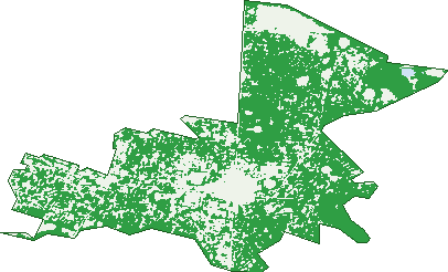
Green: 10 m cells where trees dominate, satellite 2021. Blue: water. The line is the suburb boundary.
| Canopy share, 1 m canopy height map, 2020 | 23.6% |
|---|---|
| Land with trees, 10 m satellite map, 2021 | 69.6% |
Demographics
Unemployment 4.3% · Labour-force participation 63.4%
Population by age in Boronia
| 0-4 | 1,441 |
|---|---|
| 5-14 | 2,595 |
| 15-19 | 1,111 |
| 20-24 | 1,278 |
| 25-34 | 3,733 |
| 35-44 | 3,602 |
| 45-54 | 2,970 |
| 55-64 | 2,644 |
| 65-74 | 2,357 |
| 75-84 | 1,370 |
| 85+ | 518 |
Dwelling types in Boronia
| House | 6,685 |
|---|---|
| Townhouse | 2,316 |
| Apartment | 319 |
| Other | 5 |
Households by weekly income in Boronia
| <$650 | 1,436 |
|---|---|
| $650-1,499 | 2,696 |
| $1,500-2,999 | 3,134 |
| $3,000+ | 1,560 |
Top ancestries in Boronia
| English | 8,320 |
|---|---|
| Australian | 7,627 |
| Other | 2,689 |
| Irish | 2,244 |
| Scottish | 2,160 |
| Chinese | 1,934 |
Housing tenure in Boronia
| Owned | 2,812 |
|---|---|
| Mortgage | 3,711 |
| Rented | 2,625 |
| Other | 79 |
Cars per household in Boronia
| 0 | 457 |
|---|---|
| 1 | 3,595 |
| 2 | 3,666 |
| 3 | 1,040 |
| 4+ | 461 |
Commute to work in Boronia
| Car | 6,795 |
|---|---|
| Train | 212 |
| Bus | 74 |
| Tram/ferry | 10 |
| Walked | 120 |
| Bicycle | 44 |
| Home | 2,889 |
Top countries of birth in Boronia
| England | 924 |
|---|---|
| China | 791 |
| India | 669 |
| Sri Lanka | 386 |
| Malaysia | 342 |
| New Zealand | 306 |
Languages used at home in Boronia
| Mandarin | 996 |
|---|---|
| Cantonese | 511 |
| Sinhalese | 322 |
| Gujarati | 186 |
| Hindi | 180 |
| Persian | 172 |
Birds & Wildlife Nearby
87,943 bird observations recorded near Boronia — most often seen:
- Little Raven (4,595)
- Australian Magpie (4,585)
- Rainbow Lorikeet (4,316)
- Noisy Miner (4,289)
- Sulphur-crested Cockatoo (4,223)
- Red Wattlebird (4,144)
- Crimson Rosella (3,811)
- Common Myna (3,614)
- Australian Wood Duck (3,406)
- Brown Thornbill (3,373)
- Laughing Kookaburra (3,341)
- Pacific Black Duck (3,223)
- Grey Butcherbird (3,195)
Show all 30 birds recorded near Boronia
- Eurasian Blackbird (3,108)
- Pied Currawong (3,024)
- Grey Fantail (2,729)
- Spotted Turtle-dove (2,668)
- Magpie-lark (2,658)
- Southern Victoria Australian Magpie (2,281)
- Welcome Swallow (2,236)
- Superb Fairy-wren (2,127)
- Eurasian Coot (2,121)
- Galah (1,995)
- Australasian Purple Swamphen (1,985)
- Eastern Rosella (1,938)
- Australian King-parrot (1,937)
- Dusky Moorhen (1,890)
- Spotted Pardalote (1,864)
- White-browed Scrubwren (1,637)
- Eastern Yellow Robin (1,630)
Sightings reported by observers, not a survey, so the counts show what people record rather than what lives here. Source: Atlas of Living Australia.
Nearby Suburbs
The closest suburbs to Boronia:
- Bayswater (2.1 km)
- The Basin (2.6 km)
- Ferntree Gully (2.8 km)
- Bayswater North (3.4 km)
- Kilsyth South (3.9 km)
- Knoxfield (4.5 km)
- Wantirna South (4.6 km)
- Heathmont (4.7 km)
Embed this suburb
Add this free Boronia stat card to your own site — just copy the code:
Preview:
Cite this page
Quoting these figures? Copy the credit line:
Keep an eye on Boronia
One email when this data meaningfully changes — new census figures, prices, rankings. No spam, unsubscribe anytime.
Streets
- Albert Avenue (351)
- Alchester Crescent (39)
- Alfred Street (13)
- Alison Avenue (23)
- Allandale Road (59)
- Allanfield Crescent (64)
- Annette Grove (7)
- Arcadia Avenue (1)
- Army Road (109)
- Aubrey Grove (103)
- Avington Crescent (53)
- Bailey Street (10)
- Baldwin Avenue (43)
- Bambil Court (7)
- Bambury Street (184)
- Barbara Avenue (16)
- Batavia Avenue (10)
- Battalion Court (13)
- Beech Court (7)
- Bellevue Court (17)
- Bellrise Court (5)
- Benbow Crescent (26)
- Bennett Street (32)
- Beresford Drive (85)
- Biscay Court (18)
- Blamey Court (9)
- Blythe Avenue (30)
- Bogan Court (6)
- Boronia Road (915)
- Bouganville Street (14)
- Bradley Place (6)
- Bradman Court (15)
- Briar Street (11)
- Brown Street (15)
- Browning Road (55)
- Buchanan Street (43)
- Buna Court (12)
- Burston Road (12)
- Bushview Glade (10)
- Cardiff Street (33)
- Castlewood Drive (19)
- Casuarina Avenue (36)
- Catesby Court (23)
- Catherine Street (51)
- Cedar Crescent (14)
- Central Avenue (197)
- Chandler Road (235)
- Charlotte Road (36)
- Clover Court (8)
- Cobbitty Court (23)
- Coleman Road (31)
- Conway Court (64)
- Coogee Street (24)
- Coppice Court (10)
- Coral Court (6)
- Cottesmore Court (5)
- Coull Close (9)
- Crotty Road (19)
- Currawa Drive (62)
- Cypress Avenue (137)
- Daffodil Road (101)
- Damar Avenue (18)
- Darwin Road (61)
- Davey Street (13)
- Dawn Street (16)
- Deborah Avenue (31)
- Debson Close (19)
- Denby Court (6)
- Derby Road (21)
- Devenish Road (143)
- Dinsdale Road (53)
- Dixon Court (130)
- Donald Court (27)
- Dorrigo Drive (22)
- Dorset Road (677)
- Dorset Square (71)
- Douglas Street (12)
- Duncan Avenue (79)
- Early Place (7)
- Elder Grove (15)
- Elliott Street (14)
- Elsie Street (143)
- Emerald Court (18)
- Enderby Court (9)
- Erica Avenue (29)
- Esther Court (19)
- Ethel Street (23)
- Eugenia Court (14)
- Falconer Road (64)
- Faraday Street (59)
- Fleur Court (8)
- Flinders Crescent (28)
- Floriston Road (87)
- Forest Road (141)
- Freedman Avenue (13)
- Garden Avenue (25)
- Gaynor Court (9)
- Genista Avenue (42)
- Gertonia Avenue (148)
- Gideon Close (7)
- Gilja Court (7)
- Girdwood Road (71)
- Glenann Court (17)
- Glenburn Road (4)
- Glenda Court (4)
- Glendale Court (12)
- Gordon Crescent (10)
- Green Street (22)
- Gregory Road (18)
- Grevillea Avenue (26)
- Gwyn Crescent (23)
- Haering Road (44)
- Hansen Road (37)
- Harcourt Road (63)
- Harewood Close (23)
- Harnett Street (25)
- Hastings Avenue (50)
- Hayles Street (19)
- Hazelwood Road (101)
- Helene Court (33)
- Henry Street (75)
- Herbert Street (63)
- Hilda Avenue (68)
- Hillside Avenue (25)
- Hovea Court (6)
- Icarus Court (15)
- Indigo Place (6)
- Interman Road (35)
- Iris Crescent (72)
- Isa Way (12)
- Jaffa Court (5)
- Jane Court (6)
- Janet Street (28)
- Janville Street (29)
- Jarrah Court (6)
- Jema Court (8)
- Jordan Court (22)
- Joyce Street (34)
- Judith Avenue (28)
- Jukes Road (8)
- Kalman Drive (72)
- Kanooka Road (98)
- Karri Court (4)
- Kay Court (14)
- Keats Court (7)
- Kleinert Road (51)
- Kokoda Court (14)
- Kristen Court (11)
- Krystal Glenn Gardens (13)
- Lachlan Road (18)
- Landscape Drive (79)
- Langwith Avenue (15)
- Laurel Avenue (103)
- Laurella Close (7)
- Lemal Avenue (23)
- Leslie Avenue (19)
- Lewis Road (4)
- Liverpool Road (3)
- Lockwoods Road (47)
- Lorikeet Court (16)
- Lorraine Street (17)
- Lucas Close (8)
- Lyell Road (20)
- Lyndon Road (20)
- Lynette Street (24)
- Lyrebird Court (17)
- Macquarie Place (119)
- Madge Street (8)
- Malcolm Street (11)
- Manuka Drive (18)
- Margaret Avenue (3)
- Marie Street (37)
- Market Street (32)
- Marland Road (54)
- Marong Court (10)
- Marville Court (20)
- Maryborough Road (75)
- Maryville Way (1)
- Matlock Road (30)
- Mcdonald Crescent (64)
- Medway Crescent (27)
- Melrose Court (17)
- Miller Road (9)
- Minton Close (9)
- Mitchell Avenue (27)
- Moncoe Street (62)
- Mont Albert Road (1)
- Montana Avenue (17)
- Montclaire Court (7)
- Morley Court (6)
- Moroney Street (69)
- Mount View Road (81)
- Mountain Highway (168)
- Murene Court (38)
- Narcissus Avenue (177)
- New Street (20)
- Nickols Court (21)
- Normleith Grove (23)
- Norwich Street (17)
- Nyora Avenue (6)
- Oak Avenue (114)
- Olive Grove (103)
- Orchid Avenue (57)
- Owen Street (62)
- Paisley Avenue (24)
- Paloma Court (7)
- Park Crescent (74)
- Parker Avenue (46)
- Pascoe Road (23)
- Paton Crescent (100)
- Patrick Court (16)
- Penrith Street (16)
- Peron Court (8)
- Petersfield Court (11)
- Philippa Road (13)
- Phipps Avenue (16)
- Phyllis Avenue (41)
- Pine Crescent (189)
- Pinevale Court (17)
- Pope Avenue (37)
- Power Road (60)
- Prospect Place (44)
- Queenstown Road (24)
- Rabaul Court (10)
- Ramona Court (14)
- Rangeview Road (42)
- Rankin Road (138)
- Rathmullen Road (98)
- Rawdon Court (17)
- Redfern Court (13)
- Reve Street (16)
- Rob Court (7)
- Robertson Crescent (56)
- Ronald Crescent (24)
- Rose Avenue (61)
- Rosella Avenue (115)
- Roselyn Crescent (27)
- Rothan Avenue (21)
- Rowan Avenue (18)
- Rowson Street (68)
- Roy Court (27)
- Royalden Close (37)
- Royston Court (18)
- Rubida Court (12)
- Russell Crescent (56)
- Rustic Drive (7)
- Salmon Road (17)
- Sandpiper Court (25)
- Sapphire Avenue (18)
- Sassafras Court (14)
- Sasses Avenue (1)
- Scoresby Road (360)
- Sedgwick Road (17)
- Shalimar Crescent (20)
- Shelly Avenue (10)
- Shirley Court (14)
- Short Street (39)
- Southern Aurora Place (11)
- Southey Road (53)
- Springfield Road (88)
- Stewart Street (145)
- Stonehaven Avenue (90)
- Stoneleigh Avenue (28)
- Stradbroke Road (62)
- Strahan Court (17)
- Summit Court (9)
- Sundew Avenue (60)
- Sutton Avenue (20)
- Sycamore Crescent (27)
- Tarakan Street (10)
- Taranto Court (11)
- Tarraleah Place (21)
- Tathra Court (6)
- Teak Court (15)
- Thanos Court (13)
- The Grove (20)
- Thelma Avenue (21)
- Timewell Crescent (41)
- Timor Court (7)
- Tolhurst Avenue (47)
- Tormore Road (63)
- Torrens Avenue (33)
- Torresdale Drive (81)
- Tulip Crescent (250)
- Tunstall Avenue (34)
- Unavale Crescent (21)
- Underwood Road (38)
- Valerie Street (70)
- Vivienne Avenue (24)
- Wadhurst Drive (89)
- Wadi Street (14)
- Warbler Court (34)
- Wattletree Road (17)
- Wayne Avenue (9)
- Wedmore Road (40)
- Wells Avenue (27)
- Western Road (117)
- Westmere Drive (17)
- Weyburn Road (17)
- Wilhelma Avenue (3)