Blackburn VIC 3130
8,810 addresses · 182 streets
Chisholm Electorate › Whitehorse LGA › Blackburn · 16 km from Melbourne
📦 Thinking of moving here? Read the Blackburn moving guide

Living Here
A leafy established eastern Melbourne suburb known for its lake and gardens, Blackburn is family-oriented. Households average 2.5 people and the median age is 41. Median household income is $2,065 a week, with rent around $411.
Blackburn is a suburb of Victoria, home to about 14,478 people, with a median age of 41. The typical household earns around $2,065 a week, with median rent near $411 a week. Most homes are houses. About 73% of households own their home and 26% rent. Most workers work from home. Common community backgrounds include English, Australian, Chinese. On the ABS socio-economic scale it sits in decile 10 of 10 nationally — a relatively advantaged area. The median house sells for about $1,517,000.
Over time — Census 2001 → 2021
Dashed line: district figures for the Blackburn statistical area (SA2), the smallest area the ABS published before 2011. Solid line: Blackburn itself.
Getting Around & Local Services
2 physiotherapists
1 dog park
Getting around. Train station: Blackburn, 50 m north-west · Tram stop: Stop 58: Box Hill Central, 2.5 km west · Railway halt: Box Hill, 3.8 km north-west · Bus interchange: Box Hill Station, 2.5 km west · Airport: Moorabbin Airport, 18.2 km south.
Sport & Recreation
5 facilities recorded in Blackburn.
- Blackburn Bowling Club Lawn Bowls
- Box Hill Futsal ( Box Hill High School) Soccer (Indoor Soccer / Futsal)
- Curves Blackburn Fitness / Gymnasium Workouts
- Kalang Park Australian Rules Football, Cricket
- Morton Park Australian Rules Football, Cricket, Tennis (Outdoor)
Socio-economic Standing
Deciles from 1 (lowest) to 10 (highest), against all Australian suburbs. The overall figure weighs advantage and disadvantage together; economic resources counts income and housing, and education & jobs counts qualifications and occupation. They often differ. Source: ABS SEIFA 2021.
Median Sale Prices
Median of recorded sales in the period, not a valuation. Source: Victorian Property Sales Report, Land Use Victoria.
Tree cover
🌳 Tree canopy: 25.4% share of land under canopy · satellite map, 2020
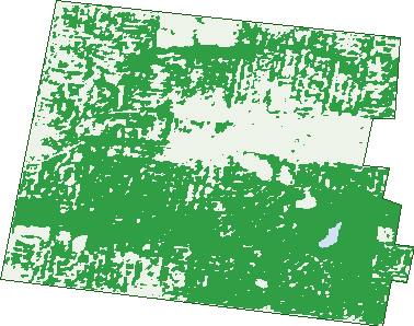
Green: 10 m cells where trees dominate, satellite 2021. Blue: water. The line is the suburb boundary.
| Canopy share, 1 m canopy height map, 2020 | 25.4% |
|---|---|
| Land with trees, 10 m satellite map, 2021 | 68.7% |
Demographics
Unemployment 4.5% · Labour-force participation 64.8%
Population by age in Blackburn
| 0-4 | 569 |
|---|---|
| 5-14 | 1,724 |
| 15-19 | 917 |
| 20-24 | 1,007 |
| 25-34 | 1,759 |
| 35-44 | 1,958 |
| 45-54 | 2,062 |
| 55-64 | 1,798 |
| 65-74 | 1,298 |
| 75-84 | 850 |
| 85+ | 535 |
Dwelling types in Blackburn
| House | 3,668 |
|---|---|
| Townhouse | 1,184 |
| Apartment | 704 |
| Other | 0 |
Households by weekly income in Blackburn
| <$650 | 752 |
|---|---|
| $650-1,499 | 1,238 |
| $1,500-2,999 | 1,518 |
| $3,000+ | 1,765 |
Top ancestries in Blackburn
| English | 4,536 |
|---|---|
| Australian | 3,930 |
| Chinese | 2,564 |
| Irish | 1,703 |
| Other | 1,478 |
| Scottish | 1,443 |
Housing tenure in Blackburn
| Owned | 2,195 |
|---|---|
| Mortgage | 1,806 |
| Rented | 1,440 |
| Other | 65 |
Cars per household in Blackburn
| 0 | 354 |
|---|---|
| 1 | 2,417 |
| 2 | 2,017 |
| 3 | 465 |
| 4+ | 257 |
Commute to work in Blackburn
| Car | 2,817 |
|---|---|
| Train | 289 |
| Bus | 40 |
| Tram/ferry | 3 |
| Walked | 121 |
| Bicycle | 45 |
| Home | 3,066 |
Top countries of birth in Blackburn
| China | 1,181 |
|---|---|
| India | 617 |
| England | 420 |
| Malaysia | 366 |
| New Zealand | 161 |
| Vietnam | 134 |
Languages used at home in Blackburn
| Mandarin | 1,499 |
|---|---|
| Cantonese | 470 |
| Hindi | 186 |
| Punjabi | 160 |
| Greek | 146 |
| Vietnamese | 117 |
Birds & Wildlife Nearby
217,935 bird observations recorded near Blackburn — most often seen:
- Little Raven (16,690)
- Southern Victoria Australian Magpie (11,881)
- Eastern Rainbow Lorikeet (11,030)
- Pacific Black Duck (10,867)
- Noisy Miner (10,620)
- Southern Noisy Miner (10,578)
- Rainbow Lorikeet (10,425)
- Common Myna (10,299)
- Australian Magpie (10,275)
- Eastern Asian Spotted Dove (8,532)
- Spotted Turtle-dove (8,073)
- Red Wattlebird (7,269)
- South-eastern Grey Butcherbird (7,018)
Show all 30 birds recorded near Blackburn
- Grey Butcherbird (6,618)
- Pied Currawong (6,523)
- Eastern Red Wattlebird (6,361)
- Magpie-lark (5,466)
- Tawny Frogmouth (5,416)
- Dusky Moorhen (5,287)
- Eurasian Blackbird (5,174)
- Australian Wood Duck (5,045)
- Chestnut Teal (5,021)
- Southern Magpie-lark (5,020)
- Laughing Kookaburra (4,347)
- Brown Thornbill (4,312)
- Eastern Crested Pigeon (4,193)
- Eastern Rosella (4,082)
- South-eastern Musk Lorikeet (4,060)
- Australasian Purple Swamphen (3,890)
- Crested Pigeon (3,563)
Sightings reported by observers, not a survey, so the counts show what people record rather than what lives here. Source: Atlas of Living Australia.
Nearby Suburbs
The closest suburbs to Blackburn:
- Blackburn North (1.6 km)
- Blackburn South (2.1 km)
- Nunawading (2.3 km)
- Box Hill North (2.4 km)
- Box Hill (2.5 km)
- Forest Hill (2.7 km)
- Box Hill South (3.1 km)
- Burwood East (3.6 km)
Embed this suburb
Add this free Blackburn stat card to your own site — just copy the code:
Preview:
Cite this page
Quoting these figures? Copy the credit line:
Keep an eye on Blackburn
One email when this data meaningfully changes — new census figures, prices, rankings. No spam, unsubscribe anytime.
Streets
- Acacia Avenue (19)
- Alandale Court (6)
- Alandale Road (51)
- Albert Street (55)
- Alfred Street (41)
- Almer Avenue (12)
- Almondsbury Court (8)
- Amery Avenue (42)
- Anjaya Court (16)
- Apollo Court (22)
- Arna Street (13)
- Ashburn Place (11)
- Ashlar Crescent (35)
- Athol Court (20)
- Attunga Street (10)
- Badenoch Street (25)
- Baldwin Road (98)
- Banksia Street (28)
- Beatrice Court (7)
- Beck Street (2)
- Bell Street (1)
- Bent Street (4)
- Beverley Crescent (34)
- Blackburn Road (250)
- Boongarry Avenue (19)
- Bordeaux Avenue (29)
- Boulton Road (10)
- Broomhill Avenue (28)
- Canterbury Road (191)
- Carey Court (3)
- Central Road (66)
- Chapel Street (24)
- Clare Street (28)
- Clarke Street (10)
- Clifton Street (35)
- Cloverlea Court (6)
- Cootamundra Crescent (56)
- Cottage Street (36)
- Cromwell Court (23)
- Derby Street (21)
- Dewrang Crescent (42)
- Dickens Street (35)
- Diggers Way (1)
- Dixon Grove (32)
- Doogan Street (3)
- Dora Avenue (17)
- Doulton Road (34)
- Downing Street (27)
- Duckham Street (27)
- Dwyer Street (17)
- Elder Street (60)
- Ellison Street (22)
- Elm Street (23)
- Elmhurst Road (91)
- Erli Court (9)
- Ernest Street (21)
- Esdale Street (59)
- Eustace Street (26)
- Fir Street (14)
- Florence Street (27)
- Forest Road (18)
- Francis Street (54)
- Frankcom Street (73)
- Frederick Street (4)
- Fuchsia Street (43)
- Fulview Court (5)
- Furness Street (8)
- Game Street (18)
- Gardenia Street (103)
- Garie Street (11)
- George Street (31)
- Gerald Street (44)
- Glen Ebor Avenue (111)
- Goodwin Street (84)
- Gordon Crescent (26)
- Gresham Place (5)
- Gwenda Avenue (13)
- Halley Street (52)
- Hamilton Avenue (40)
- Handel Court (10)
- Harold Street (43)
- Harry Street (2)
- Hartigan Street (22)
- Haydn Street (14)
- Heath Street (14)
- Hill Street (8)
- Hillside Crescent (42)
- Hindon Street (23)
- Hirst Street (37)
- Janet Street (8)
- Jeffery Street (52)
- John Holland Court (25)
- John Street (92)
- Jubilee Street (11)
- Justina Street (20)
- Kalang Street (11)
- Kalka Street (14)
- Kerr Street (68)
- Kerrylyn Court (7)
- Kevin Avenue (28)
- King Street (11)
- Kinkora Road (35)
- Laburnum Street (231)
- Lagoona Court (7)
- Lake Road (73)
- Lalwa Street (22)
- Langtree Court (15)
- Larch Street (46)
- Laurel Grove N (46)
- Laurel Grove S (37)
- Lawson Street (15)
- Leons Court (12)
- Linden Street (52)
- Linum Street (34)
- Lithgow Avenue (54)
- Loris Street (3)
- Luke Avenue (8)
- Main Street (255)
- Malabar Road (49)
- Malcolm Street (43)
- Maple Street (74)
- Marian Court (16)
- Mary Street (22)
- Masons Road (38)
- Mckinnon Street (3)
- Meyer Close (15)
- Middleborough Road (364)
- Minna Street (36)
- Molleton Street (31)
- Musk Street (19)
- Myrtle Grove (57)
- Naughton Grove (47)
- Norris Court (12)
- Norvel Street (14)
- Norway Avenue (34)
- Ohara Street (58)
- Oliver Avenue (22)
- Orana Street (15)
- Ottawa Avenue (10)
- Pakenham Street (117)
- Park Street (11)
- Parkside Street (22)
- Patricia Road (33)
- Peacedale Grove (13)
- Peak Court (8)
- Pope Road (54)
- Queen Street (529)
- Railway Road (222)
- Rhubane Court (6)
- Ronley Street (24)
- Rosalind Crescent (50)
- Salisbury Avenue (96)
- Selwyn Street (23)
- Sergeant Street (129)
- Service Road (79)
- Sheehans Road (43)
- Solwood Lane (4)
- South Parade (115)
- Springfield Road (242)
- Stanley Grove (86)
- Station Street (109)
- Steel Lane (1)
- Suffolk Street (14)
- Surrey Road (194)
- Tara Avenue (23)
- Terra Cotta Drive (28)
- The Avenue (57)
- The Ridge (47)
- The Terrace (8)
- Thiele Court (18)
- Tyrrell Avenue (78)
- Vine Street (64)
- Walsham Road (24)
- Waratah Crescent (2)
- Wellington Avenue (51)
- Whitehorse Road (786)
- Williams Road (74)
- Windermere Court (15)
- Wirreanda Court (11)
- Wolseley Crescent (64)
- Woorrwarren Lane (6)
- Wright Street (19)