Berwick VIC 3806
24,071 addresses · 952 streets
La Trobe Electorate › Casey LGA › Berwick · 42 km from Melbourne
📦 Thinking of moving here? Read the Berwick moving guide

Living Here
Berwick is an established outer-south-eastern suburb with a village centre and leafy family estates. Households average 2.9 people and the median age is 38. Combined household income is strong at $2,113 a week, with rent about $400.
Berwick is a suburb of Victoria, home to about 50,298 people, with a median age of 38. The typical household earns around $2,113 a week, with median rent near $400 a week. Most homes are houses. About 76% of households own their home and 22% rent. Most workers drive to work. Common community backgrounds include English, Australian, Irish. On the ABS socio-economic scale it sits in decile 9 of 10 nationally — a relatively advantaged area. The median house sells for about $870,000.
Over time — Census 2001 → 2021
Dashed line: district figures for the Berwick - North statistical area (SA2), the smallest area the ABS published before 2011. Solid line: Berwick itself.
Getting Around & Local Services
2 Catholic churches
2 optometrists
10 childcare & kindergartens
1 plumber
Getting around. Train station: Berwick, 550 m north · Bus interchange: Fountain Gate SC, 4.5 km north-west · Airport: Moorabbin Airport, 22.6 km west.
Sport & Recreation
11 facilities recorded in Berwick, the first 10 below.
- Arch Brown Reserve Australian Rules Football, Cricket, Tennis (Outdoor)
- Aspire Health Fitness / Gymnasium Workouts
- Berwick Fields Primary School Australian Rules Football, Cricket
- Berwick Fields Recreation Reserve Australian Rules Football, Cricket
- Berwick Leisure Centre Badminton, Fitness / Gymnasium Workouts
- Berwick Secondary College Hockey
- Cyril Molyneaux Reserve Baseball
- Edwin Flack Recreation Reserve Athletics, Australian Rules Football, Cricket, Hockey, Lawn Bowls, Netball
- Fit Gym Fitness / Gymnasium Workouts
- Kambrya College Australian Rules Football, Cricket
Socio-economic Standing
Deciles from 1 (lowest) to 10 (highest), against all Australian suburbs. The overall figure weighs advantage and disadvantage together; economic resources counts income and housing, and education & jobs counts qualifications and occupation. They often differ. Source: ABS SEIFA 2021.
Median Sale Prices
Median of recorded sales in the period, not a valuation. Source: Victorian Property Sales Report, Land Use Victoria.
Tree cover
🌳 Tree canopy: 13.3% share of land under canopy · satellite map, 2020
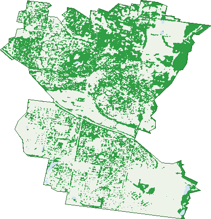
Green: 10 m cells where trees dominate, satellite 2021. Blue: water. The line is the suburb boundary.
| Canopy share, 1 m canopy height map, 2020 | 13.3% |
|---|---|
| Land with trees, 10 m satellite map, 2021 | 39.1% |
Demographics
Unemployment 4.9% · Labour-force participation 66.9%
Population by age in Berwick
| 0-4 | 2,789 |
|---|---|
| 5-14 | 7,639 |
| 15-19 | 3,623 |
| 20-24 | 3,105 |
| 25-34 | 5,441 |
| 35-44 | 7,651 |
| 45-54 | 7,449 |
| 55-64 | 5,480 |
| 65-74 | 3,735 |
| 75-84 | 2,398 |
| 85+ | 987 |
Dwelling types in Berwick
| House | 14,827 |
|---|---|
| Townhouse | 1,752 |
| Apartment | 52 |
| Other | 15 |
Households by weekly income in Berwick
| <$650 | 1,800 |
|---|---|
| $650-1,499 | 3,719 |
| $1,500-2,999 | 5,527 |
| $3,000+ | 4,629 |
Top ancestries in Berwick
| English | 14,630 |
|---|---|
| Australian | 13,520 |
| Other | 9,110 |
| Irish | 3,930 |
| Scottish | 3,909 |
| Indian | 3,738 |
Housing tenure in Berwick
| Owned | 4,754 |
|---|---|
| Mortgage | 7,688 |
| Rented | 3,658 |
| Other | 345 |
Cars per household in Berwick
| 0 | 476 |
|---|---|
| 1 | 4,733 |
| 2 | 7,374 |
| 3 | 2,474 |
| 4+ | 1,414 |
Commute to work in Berwick
| Car | 14,871 |
|---|---|
| Train | 331 |
| Bus | 46 |
| Tram/ferry | 10 |
| Walked | 159 |
| Bicycle | 33 |
| Home | 6,401 |
Top countries of birth in Berwick
| India | 3,052 |
|---|---|
| Sri Lanka | 1,961 |
| England | 1,866 |
| China | 1,459 |
| New Zealand | 858 |
| South Africa | 547 |
Languages used at home in Berwick
| Mandarin | 2,025 |
|---|---|
| Sinhalese | 1,888 |
| Hindi | 778 |
| Punjabi | 718 |
| Tamil | 716 |
| Malayalam | 586 |
Birds & Wildlife Nearby
51,324 bird observations recorded near Berwick — most often seen:
- Little Raven (2,748)
- Rainbow Lorikeet (2,669)
- Magpie-lark (2,541)
- Common Myna (2,461)
- Eurasian Blackbird (2,450)
- Noisy Miner (2,397)
- Red Wattlebird (2,392)
- Common Starling (2,273)
- Australian Magpie (2,171)
- Pacific Black Duck (1,875)
- Grey Butcherbird (1,836)
- Spotted Turtle-dove (1,731)
- Welcome Swallow (1,633)
Show all 30 birds recorded near Berwick
- Eurasian Coot (1,602)
- Galah (1,544)
- Australian Wood Duck (1,533)
- Australasian Purple Swamphen (1,532)
- Superb Fairy-wren (1,506)
- Eastern Rosella (1,463)
- Brown Thornbill (1,409)
- Sulphur-crested Cockatoo (1,384)
- Southern Victoria Australian Magpie (1,375)
- Grey Fantail (1,316)
- Dusky Moorhen (1,267)
- White-faced Heron (1,191)
- Little Pied Cormorant (1,071)
- Australian White Ibis (1,015)
- Little Wattlebird (999)
- Laughing Kookaburra (986)
- Straw-necked Ibis (954)
Sightings reported by observers, not a survey, so the counts show what people record rather than what lives here. Source: Atlas of Living Australia.
Nearby Suburbs
The closest suburbs to Berwick:
- Beaconsfield (3.1 km)
- Narre Warren South (3.9 km)
- Narre Warren (4.4 km)
- Harkaway (5.2 km)
- Cranbourne North (5.3 km)
- Guys Hill (5.4 km)
- Clyde North (6.3 km)
- Officer (6.4 km)
Embed this suburb
Add this free Berwick stat card to your own site — just copy the code:
Preview:
Cite this page
Quoting these figures? Copy the credit line:
Keep an eye on Berwick
One email when this data meaningfully changes — new census figures, prices, rankings. No spam, unsubscribe anytime.
Streets
- Farrer Place (8)
- Ferncroft Court (22)
- Fernwren Drive (18)
- Festival Terrace (27)
- Field Court (7)
- Fieldhouse Lane (29)
- Fiesta Lane (11)
- Filante Grove (10)
- Finch Street (6)
- Findon Way (7)
- Fisher Close (15)
- Fleer Way (8)
- Florence Avenue (52)
- Florida Court (12)
- Florio Close (5)
- Flotilla Place (8)
- Flowerfield Court (6)
- Foulds Court (16)
- Fritzlaff Court (18)
- Frognal Mews (3)
- Funston Street (17)
- Furness Court (10)
- Furphy Court (7)
- Fusco Terrace (6)
- Fyffe Street (5)
- Gair Close (2)
- Gamaret Place (8)
- Gamble Avenue (26)
- Ganaway Drive (22)
- Garden Court (11)
- Gardiner Street (90)
- Gargeney Court (5)
- Gavinton Place (18)
- Gaylard Court (5)
- Gellibrand Court (8)
- Georgina Place (12)
- Geranium Court (16)
- Gibb Street (18)
- Gifford Close (19)
- Gilbert Place (9)
- Gingham Place (12)
- Glade Court (11)
- Gladys Court (12)
- Glasshouse Court (9)
- Glen Moidart Drive (20)
- Glenbrae Court (13)
- Glendale Crescent (23)
- Glenisla Way (26)
- Glenmaggie Close (18)
- Glenn Erin Way (39)
- Glenside Walk (20)
- Glenview Rise (48)
- Gloucester Avenue (413)
- Glover Court (8)
- Golf Links Road (179)
- Gomery Court (18)
- Goodall Court (13)
- Gooseberry Mews (12)
- Grand Arch Way (49)
- Grand Manor Drive (23)
- Graneel Grove (23)
- Grant Close (41)
- Grantham Crescent (41)
- Grayden Drive (13)
- Greaves Road (1)
- Greenhaven Terrace (6)
- Greenlaw Crescent (23)
- Greenwich Drive (47)
- Grenville Court (22)
- Gretel Place (8)
- Greystoke Court (25)
- Grices Road (56)
- Grigg Street (16)
- Grove Gardens (22)
- Gumnut Court (20)
- Gwendoline Drive (21)
- Hackberry Place (6)
- Hagen Drive (12)
- Halifax Drive (17)
- Hall Court (7)
- Hamdon Green (4)
- Hanawa Place (12)
- Hancock Drive (52)
- Harbin Alley (12)
- Harcourt Way (14)
- Hardy Court (22)
- Harkaway Road (87)
- Harlem Way (34)
- Harley Court (8)
- Harmon Close (27)
- Hartsmere Drive (50)
- Hartville Place (7)
- Harwood Court (22)
- Hasken Court (6)
- Hatten Place (10)
- Havelock Place (1)
- Haverbrack Drive (19)
- Hawker Gardens (13)
- Hawkesbury Street (14)
- Hayman Street (16)
- Hazeldene Court (49)
- Hazelnut Boulevard (15)
- Heard Close (9)
- Hedgeley Drive (41)
- Heidi Way (14)
- Hepburn Court (7)
- Hereford Close (10)
- Hessell Road (8)
- Hewa Place (6)
- Hibberd Court (14)
- High Street (284)
- Highfielde Avenue (46)
- Highvale Crescent (44)
- Higinbotham Rise (6)
- Hilda Court (8)
- Hillandale Rise (12)
- Hillary Court (9)
- Hillgrove Crescent (48)
- Hillman Court (14)
- Hillsborough Crescent (22)
- Hillview Place (19)
- Hobart Avenue (33)
- Holder Place (9)
- Hollington Way (13)
- Hollydale Close (15)
- Hollyrood Drive (20)
- Hollywood Boulevard (9)
- Homestead Road (196)
- Honey Court (15)
- Hood Court (13)
- Howard Place (10)
- Howell Drive (47)
- Howitt Court (30)
- Hyland Court (15)
- Illes Court (8)
- Illowra Court (16)
- Imer Crescent (29)
- Indio Lane (4)
- Infantry Way (23)
- Inga Court (9)
- Inglis Road (66)
- Inkerman Street (26)
- Innes Court (70)
- Insignia Crescent (46)
- Intrepid Street (73)
- Irving Close (10)
- Jack William Way (35)
- Jacob Court (9)
- Jacqueline Court (11)
- Jamie Mews (7)
- Jamieson Way (52)
- Jancol Court (7)
- Jane Street (57)
- Janna Place (19)
- Jarryd Crescent (78)
- Jason Close (16)
- Jay Rise (6)
- Jembecca Drive (22)
- Jericho Court (31)
- Jerilderie Drive (99)
- Jessica Mews (16)
- Jeune Grove (7)
- Jianni Way (22)
- Jim Court (3)
- John Fisher Drive (49)
- Jomary Court (13)
- Juliet Way (25)
- Julius Court (6)
- Jumbuck Court (8)
- Kalanchoe Place (8)
- Kalari Close (6)
- Kalastaire Grove (18)
- Kalimna Avenue (5)
- Kangan Drive (284)
- Karwin Close (6)
- Kate Elizabeth Avenue (22)
- Kelburn Road (47)
- Kelly Mews (9)
- Kelso Place (6)
- Kempson Walk (4)
- Kenny Court (12)
- Kerferd Street (9)
- Kerry Close (15)
- Kiah Place (3)
- Kilkieran Place (11)
- Killarney Court (9)
- Kilvington Court (34)
- Kimbarra Drive (12)
- Kimberly Court (11)
- Kingsmere Drive (14)
- Kingsmill Terrace (11)
- Kinsale View (16)
- Kinta Close (7)
- Kirkfell Court (10)
- Kirkham Court (27)
- Kirrabilli Parade (18)
- Kirrilee Court (10)
- Knox Street (13)
- Konac Court (5)
- Koorang Place (7)
- Kramer Drive (48)
- Kruger Street (8)
- Kuranda Crescent (29)
- Kurnwill Place (9)
- Laburnum Street (11)
- Ladd Way (4)
- Lakeside Drive (25)
- Lakewood Place (17)
- Landra Court (10)
- Langmore Lane (157)
- Lango Court (7)
- Larne Close (6)
- Lauder Place (5)
- Lauradan Avenue (10)
- Lavender Place (7)
- Lawrence Drive (60)
- Lawton Grove (16)
- Leemak Crescent (34)
- Leichhardt Way (6)
- Leisurewood Drive (25)
- Lemongrove Way (21)
- Lena Court (6)
- Leonard Avenue (28)
- Lexcen Close (20)
- Lexington Parade (36)
- Lia Amie Place (15)
- Liara Boulevard (21)
- Liberty Avenue (12)
- Liege Close (4)
- Lightwood Court (17)
- Lilac Crescent (13)
- Lily Vale Close (8)
- Limestone Drive (59)
- Limousin Court (11)
- Lincoln Avenue (22)
- Lindeman Street (24)
- Linnet Place (3)
- Linton Court (9)
- Lisa Place (4)
- Lisburn Way (26)
- Lisson Court (8)
- Little Gem Way (10)
- Llano Circuit (47)
- Loders Way (11)
- Lodge Crescent (77)
- Logan Place (12)
- Lords Rise (3)
- Lorikeet Drive (37)
- Lorimer Street (24)
- Lorne Court (18)
- Loveridge Walk (9)
- Lowanna Street (10)
- Luke Place (1)
- Luscombe Court (11)
- Lyall Road (85)
- Lydia Mary Drive (43)
- Lynch Court (13)
- Lyndal Court (14)
- Lyrebird Gardens (9)
- Lysanne Crescent (48)
- Macreadie Drive (44)
- Madden Retreat (10)
- Magarra Crescent (17)
- Magdalena Place (16)
- Magnifica Close (7)
- Mahogany Avenue (14)
- Malanda Court (10)
- Malibu Circuit (10)
- Mallaig Rise (5)
- Mallard Street (21)
- Mallee Court (3)
- Maltby Court (9)
- Mandalay Court (6)
- Manders Street (29)
- Mandurah Chase (12)
- Manor Oak Place (14)
- Manorwood Way (15)
- Mansell Court (6)
- Mansfield Street (195)
- Manuka Road (93)
- Maralee Court (13)
- Marbelia Drive (18)
- Margaret Street (41)
- Margarita Close (7)
- Marida Court (15)
- Marija Crescent (44)
- Marina Court (20)
- Marisa Crescent (84)
- Marlborough Road (62)
- Marlesford Crescent (131)
- Marsh Grove (48)
- Martin Court (3)
- Mary Court (6)
- Marygate Place (2)
- Maryn Close (39)
- Mason Way (12)
- Masquerade Road (52)
- Matheson Court (17)
- Mathoura Court (21)
- Max Drive (3)